- Australia ▾
- Topographic
▾
- Australia AUSTopo 250k (2025)
- Australia 50k Geoscience maps
- Australia 100k Geoscience maps
- Australia 250k Geoscience maps
- Australia 1:1m Geoscience maps
- New Zealand 50k maps
- New Zealand 250k maps
- New South Wales 25k maps
- New South Wales 50k maps
- New South Wales 100k maps
- Queensland 10k maps
- Queensland 25k maps
- Queensland 50k maps
- Queensland 100k maps
- Western Australia 25k maps
- Western Australia 50k maps
- Western Australia 100k maps
- Compasses
- Software
- GPS Systems
- International ▾
- Wall Maps
▾
- World
- Australia & New Zealand
- Countries, Continents & Regions
- Historical
- Vintage National Geographic
- Australian Capital Territory
- New South Wales
- Northern Territory
- Queensland
- South Australia
- Tasmania
- Victoria
- Western Australia
- Celestial
- Children's
- Mining & Resources
- Wine Maps
- Healthcare
- Postcode Maps
- Electoral Maps
- Nautical ▾
- Flags
▾
- Australian Flag Sets & Banners
- Flag Bunting
- Handwavers
- Australian National Flags
- Aboriginal Flags
- Torres Strait Islander Flags
- International Flags
- Flagpoles & Accessories
- Australian Capital Territory Flags
- New South Wales Flags
- Northern Territory Flags
- Queensland Flags
- South Australia Flags
- Tasmania Flags
- Victoria Flags
- Western Australia Flags
- Gifts ▾
- Globes ▾
Dear valued customer. Please note that our checkout is not supported by old browsers. Please use a recent browser to access all checkout capabilities


Wollondily District Craigies Map
$14.95
Afterpay is only available for orders between $50.00 and $1000.00 More info
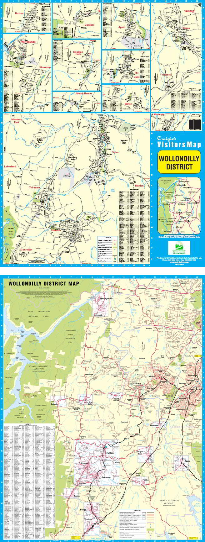
Wollondilly District Map – Craigies Maps
Explore the historic towns, rural villages, and natural beauty of Sydney’s great southwestern fringe
The Wollondilly District Map by Craigies is your trusted guide to one of New South Wales’ most historically rich and geographically diverse regions. From the heritage heart of Picton to the bushland serenity of Lake Burragorang, this map offers clear, reliable navigation for locals, visitors, and service providers alike.
Covering a broad area from Warragamba in the north to Yanderra in the south, extending westward to the edge of Lake Burragorang and eastward to Campbelltown, this detailed map combines regional and street-level data in one comprehensive resource.
📍 Map Coverage Includes
Regional Area:
-
Warragamba and Silverdale
-
Lake Burragorang
-
The Oaks, Oakdale, and Burragorang Valley
-
Campbelltown (western edge)
-
Yanderra and Bargo corridor
-
Appin and Douglas Park
Street-Level Mapping:
-
Picton – The administrative heart of Wollondilly Shire
-
Tahmoor – A growing residential and commercial centre
-
Thirlmere – Home of the NSW Rail Museum
-
Buxton, Wilton & The Oaks – Leafy villages with community charm
-
Appin, Bargo, Menangle – Historic towns along major travel routes
-
Belimbla Park, Oakdale, Mount Hunter – Semi-rural retreats with scenic views
-
Warragamba – Gateway to the dam and Blue Mountains access
🧭 Map Features
| Feature | Description |
|---|---|
| 🗺️ District Map Scale | 1:100,000 – Ideal for exploring the region’s broader landscape and road network |
| 🏘️ Street Map Scale | 1:30,000 – Detailed urban mapping for key towns and residential zones |
| 🌿 Geographic Features | National parks, state forests, and Lake Burragorang clearly marked |
| 🛣️ Road Networks | Includes highways, arterial roads, local streets, and rural tracks |
| 🏞️ Landmarks & Recreation | Lookouts, walking trails, picnic areas, and places of interest |
| 🧭 Navigation Support | Grid references, legible fonts, and logical layout for easy use |
📐 Specifications
| Specification | Detail |
|---|---|
| Publisher | Craigies Maps |
| Map Type | Folded district and street map |
| Map Title | Wollondilly District Map |
| Regional Scale | 1:100,000 |
| Street Scale | 1:30,000 |
| Coverage Area | Warragamba to Yanderra, Lake Burragorang to Campbelltown |
| Printed in | Australia |
🎯 Perfect For
-
🏡 Residents and local businesses navigating streets and suburbs
-
🚚 Service providers and logistics teams planning deliveries or maintenance routes
-
🧳 Tourists and day-trippers discovering Wollondilly’s villages and scenic drives
-
🚶 Hikers and nature lovers accessing bushwalks and lake viewpoints
-
🛍️ Real estate and planning professionals needing clear local boundaries and infrastructure
-
🏫 Teachers, students, and local history enthusiasts exploring cultural and geographic context
🌟 Why Choose Craigies?
With decades of experience in mapping Australian towns and regions, Craigies Maps offer unmatched clarity, accuracy, and practicality. This map is designed for real-world use — balancing visual detail with ease of navigation.
Whether you're heading to a local event, exploring backroads, or managing regional operations, the Wollondilly District Map puts the entire region in your hands.
From the rolling paddocks of The Oaks to the storied streets of Picton, explore the best of the Wollondilly region with the map trusted by locals and professionals alike.
Frequently Asked Questions
Where can I buy the Wollondily District Craigies Map?
The Wollondily District Craigies Map is available to buy online from Mapworld, Australia's largest map and geographic product retailer, with fast shipping Australia-wide.
Is the Wollondily District Craigies Map in stock at Mapworld?
Mapworld maintains extensive stock across its map range and aims for fast dispatch. Orders placed before 2pm AEST on business days are typically dispatched the same day, with standard and express Australia-wide delivery options available.
What is Mapworld's returns policy?
Mapworld accepts returns on undamaged items in original condition. Contact Mapworld within 90 days of purchase to arrange a return or exchange.
Does Mapworld ship the Wollondily District Craigies Map across Australia?
Yes, Mapworld ships Australia-wide. Standard shipping is a flat $7 rate, with free standard shipping on orders over $75. Express options are available at checkout. Most orders placed before 2pm AEST on weekdays are dispatched same day.
Related Items


© 2026 Mapworld. Website designed by Genie Media
X