- Australia ▾
- Topographic
▾
- Australia AUSTopo 250k (2025)
- Australia 50k Geoscience maps
- Australia 100k Geoscience maps
- Australia 250k Geoscience maps
- Australia 1:1m Geoscience maps
- New Zealand 50k maps
- New Zealand 250k maps
- New South Wales 25k maps
- New South Wales 50k maps
- New South Wales 100k maps
- Queensland 10k maps
- Queensland 25k maps
- Queensland 50k maps
- Queensland 100k maps
- Western Australia 25k maps
- Western Australia 50k maps
- Western Australia 100k maps
- Compasses
- Software
- GPS Systems
- International ▾
- Wall Maps
▾
- World
- Australia & New Zealand
- Countries, Continents & Regions
- Historical
- Vintage National Geographic
- Australian Capital Territory
- New South Wales
- Northern Territory
- Queensland
- South Australia
- Tasmania
- Victoria
- Western Australia
- Celestial
- Children's
- Mining & Resources
- Wine Maps
- Healthcare
- Postcode Maps
- Electoral Maps
- Nautical ▾
- Flags
▾
- Australian Flag Sets & Banners
- Flag Bunting
- Handwavers
- Australian National Flags
- Aboriginal Flags
- Torres Strait Islander Flags
- International Flags
- Flagpoles & Accessories
- Australian Capital Territory Flags
- New South Wales Flags
- Northern Territory Flags
- Queensland Flags
- South Australia Flags
- Tasmania Flags
- Victoria Flags
- Western Australia Flags
- Gifts ▾
- Globes ▾
Dear valued customer. Please note that our checkout is not supported by old browsers. Please use a recent browser to access all checkout capabilities


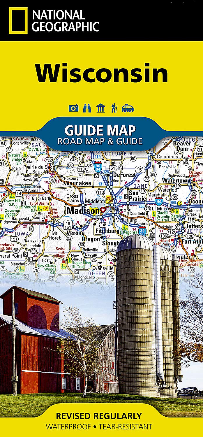

Wisconsin State National Geographic Folded Map
$29.95
Afterpay is only available for orders between $50.00 and $1000.00 More info
Wisconsin State – National Geographic Guide Map
Waterproof • Tear-Resistant • Travel Map
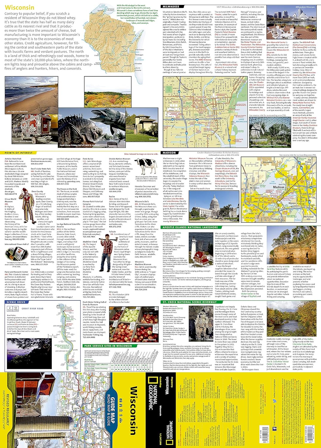
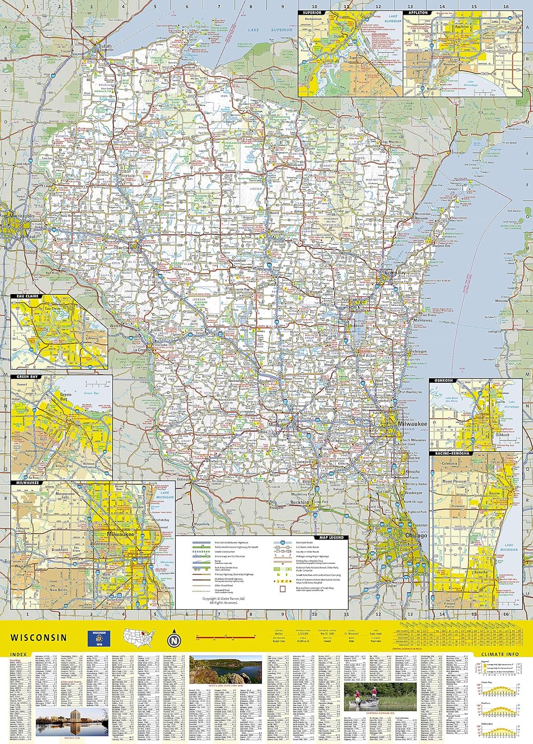
From the shores of Lake Superior and Lake Michigan to the rolling farmlands and vibrant cities, National Geographic’s Wisconsin State Guide Map is the ultimate companion for navigating the Badger State. Combining detailed cartography with expertly researched travel information, this map is perfect for road trips, outdoor adventures, and city exploration alike.
📍 Complete Statewide Coverage
-
Full Road Network – Interstates, U.S. and state highways, toll roads, scenic byways, and secondary routes clearly marked
-
Mileage Indicators – Distances in miles shown on major highways for easy trip planning
-
Key Travel Points – National and state parks, public campsites, visitor information centers, airports, ski areas, hospitals, and more
-
Recreational Data – Park service site chart and climate information to help plan outdoor activities
🗺 Insets & Special Features
-
City Insets – Madison, Milwaukee, Superior, Appleton, Oshkosh, Racine–Kenosha, Green Bay, and Eau Claire with detailed street layouts
-
Scenic Drive Highlight – Great River Road along Route 35, from La Crosse to Prairie du Chien, mapped with key stops
-
National Treasures – St. Croix National Scenic Riverway, Apostle Islands National Lakeshore, and other natural wonders marked with detailed visitor notes
📖 Travel-Friendly Design
-
User-Friendly Index – Quickly locate cities, towns, and landmarks
-
Durable Material – Waterproof and tear-resistant synthetic paper for long-lasting use
-
Compact Portability – Folds neatly for glove box, backpack, or jacket pocket storage
📐 Product Specifications
| Feature | Detail |
|---|---|
| Publisher | National Geographic Maps |
| Map Type | Folded State Guide Map |
| Material | Waterproof, tear-resistant synthetic paper |
| Format | Double-sided |
| Flat Size | 660 mm x 940 mm (26" x 37") |
| Folded Size | 102 mm x 229 mm (4" x 9") |
| Order Info | Order on Demand – Please allow 7–10 working days for delivery |
🎯 Perfect For
-
Road trippers exploring Wisconsin’s scenic byways and lake shores
-
Hikers & paddlers visiting national lakeshores, riverways, and forest trails
-
Families planning city and nature getaways in one trip
-
History & culture enthusiasts exploring heritage towns and landmarks
-
Educators & students seeking an accurate, detailed state map
With National Geographic’s Wisconsin State Guide Map, you have a reliable, rugged, and beautifully detailed travel companion—ready to guide you from the Apostle Islands to the Great River Road, and everywhere in between.
Frequently Asked Questions
What area does the Wisconsin State National Geographic Folded Map cover?
The Wisconsin State National Geographic Folded Map provides road coverage of the region named in the product title. The map covers major cities, highways, towns, and regional roads, with inset city maps for key urban centres where applicable.
Is the Wisconsin State National Geographic Folded Map up to date?
Yes, this is the current edition. Mapworld stocks the most current editions from all major publishers, updated to reflect new roads and infrastructure.
What size is this map when unfolded?
Folded maps from Mapworld's range are compact and portable. Most standard folded road or travel maps open to between A1 (594 × 841mm) and A0 (841 × 1189mm) when fully unfolded, and fold down to approximately A4 or smaller for easy storage in a glove box, bag, or backpack.
Is the Wisconsin State National Geographic Folded Map in stock at Mapworld?
Mapworld maintains extensive stock across its map range and aims for fast dispatch. Orders placed before 2pm AEST on business days are typically dispatched the same day, with standard and express Australia-wide delivery options available.
Does Mapworld ship the Wisconsin State National Geographic Folded Map across Australia?
Yes, Mapworld ships Australia-wide. Standard shipping is a flat $7 rate, with free standard shipping on orders over $75. Express options are available at checkout. Most orders placed before 2pm AEST on weekdays are dispatched same day.
Related Items


© 2026 Mapworld. Website designed by Genie Media
X