- Australia ▾
- Topographic
▾
- Australia AUSTopo 250k (2025)
- Australia 50k Geoscience maps
- Australia 100k Geoscience maps
- Australia 250k Geoscience maps
- Australia 1:1m Geoscience maps
- New Zealand 50k maps
- New Zealand 250k maps
- New South Wales 25k maps
- New South Wales 50k maps
- New South Wales 100k maps
- Queensland 10k maps
- Queensland 25k maps
- Queensland 50k maps
- Queensland 100k maps
- Western Australia 25k maps
- Western Australia 50k maps
- Western Australia 100k maps
- Compasses
- Software
- GPS Systems
- International ▾
- Wall Maps
▾
- World
- Australia & New Zealand
- Countries, Continents & Regions
- Historical
- Vintage National Geographic
- Australian Capital Territory
- New South Wales
- Northern Territory
- Queensland
- South Australia
- Tasmania
- Victoria
- Western Australia
- Celestial
- Children's
- Mining & Resources
- Wine Maps
- Healthcare
- Postcode Maps
- Electoral Maps
- Nautical ▾
- Flags
▾
- Australian Flag Sets & Banners
- Flag Bunting
- Handwavers
- Australian National Flags
- Aboriginal Flags
- Torres Strait Islander Flags
- International Flags
- Flagpoles & Accessories
- Australian Capital Territory Flags
- New South Wales Flags
- Northern Territory Flags
- Queensland Flags
- South Australia Flags
- Tasmania Flags
- Victoria Flags
- Western Australia Flags
- Gifts ▾
- Globes ▾
Dear valued customer. Please note that our checkout is not supported by old browsers. Please use a recent browser to access all checkout capabilities


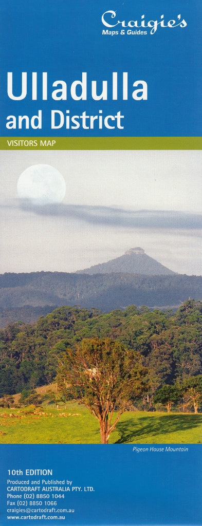
Ulladulla & District Craigies Map
$14.95
Afterpay is only available for orders between $50.00 and $1000.00 More info
Ulladulla & District Map – Craigies Maps
Your essential navigation companion for the South Coast’s seaside towns, national parks, and hinterland escapes
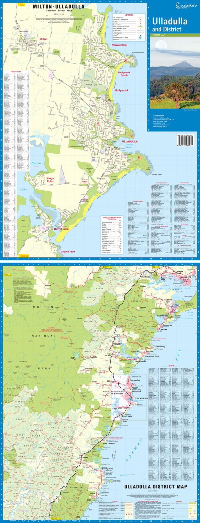
The Ulladulla & District Map by Craigies provides detailed, accurate coverage of one of New South Wales’ most scenic coastal regions. Whether you're a local resident, holidaymaker, property buyer, or road tripper, this map offers both regional context and street-level clarity across Ulladulla and its surrounding townships.
Stretching from Wandandian in the north to Merry Beach in the south, and reaching westward to the forested expanse of Morton National Park, this map is your ideal guide for exploring the sparkling shoreline, historic inland villages, and rich natural reserves of the South Coast.
📍 Map Coverage Includes
Regional Area:
-
Wandandian
-
Conjola National Park
-
Milton Hinterland
-
Morton National Park
-
Merry Beach & Kioloa Region
Street-Level Detail:
-
Ulladulla – The bustling harbour town and retail hub
-
Milton – Heritage village charm and arts scene
-
Mollymook – Popular beach and surf community
-
Narrawallee – Residential village with coastal serenity
-
Kings Point – Lakeside locale on Burrill Lake
-
Burrill Lake – Scenic waterway and peaceful retreat
🧭 Map Features
| Feature | Description |
|---|---|
| 🗺️ District Map Scale | 1:110,000 – Excellent for regional trip planning |
| 🏘️ Street Map Scale | 1:20,000 – Detailed mapping of town centres and residential areas |
| 🌿 Natural Features | National parks, state forests, and waterways clearly marked |
| 🛣️ Roads & Access | Major routes, local roads, and connectors between coastal and inland towns |
| 🏞️ Landmarks & Recreation | Lookouts, parks, reserves, beaches, and walking tracks included |
| 🧭 Navigation Aids | Clear cartographic design with labels, grids, and scale references |
📐 Specifications
| Specification | Detail |
|---|---|
| Publisher | Craigies Maps |
| Map Type | Folded street and district map |
| Map Title | Ulladulla & District |
| Regional Scale | 1:110,000 |
| Street Scale | 1:20,000 |
| Coverage | Ulladulla region, South Coast NSW |
| Printed in | Australia |
🎯 Perfect For
-
🏖️ Holidaymakers navigating South Coast beaches, towns, and accommodation
-
🚐 Caravaners and road trippers mapping scenic stops and fuel locations
-
🧭 Local residents and service providers seeking accurate street layouts
-
🌄 Bushwalkers and day trippers heading inland to Morton National Park
-
🛍️ Business operators planning deliveries, logistics, or service coverage in the region
-
📚 Teachers, schools, and visitor centres needing regional reference tools
🌟 Why Choose Craigies?
Craigies Maps are renowned for their clarity, accuracy, and local relevance. Designed and printed in Australia, each map is crafted with the needs of real travellers and residents in mind.
From vibrant village streets to quiet bushland roads, this map helps you see the bigger picture and the finer detail — all in one handy fold.
Explore the hidden coves, rolling pastures, and welcoming towns of Ulladulla and beyond — with the map trusted by locals and visitors alike.
Frequently Asked Questions
Where can I buy the Ulladulla & District Craigies Map?
The Ulladulla & District Craigies Map is available to buy online from Mapworld, Australia's largest map and geographic product retailer, with fast shipping Australia-wide.
Is the Ulladulla & District Craigies Map in stock at Mapworld?
Mapworld maintains extensive stock across its map range and aims for fast dispatch. Orders placed before 2pm AEST on business days are typically dispatched the same day, with standard and express Australia-wide delivery options available.
What is Mapworld's returns policy?
Mapworld accepts returns on undamaged items in original condition. Contact Mapworld within 90 days of purchase to arrange a return or exchange.
Does Mapworld ship the Ulladulla & District Craigies Map across Australia?
Yes, Mapworld ships Australia-wide. Standard shipping is a flat $7 rate, with free standard shipping on orders over $75. Express options are available at checkout. Most orders placed before 2pm AEST on weekdays are dispatched same day.
Related Items


© 2026 Mapworld. Website designed by Genie Media
X