- Australia ▾
- Topographic
▾
- Australia AUSTopo 250k (2024)
- Australia 50k Geoscience maps
- Australia 100k Geoscience maps
- Australia 250k Geoscience maps
- Australia 1.1m Geoscience maps
- New Zealand 50k maps
- New Zealand 250k maps
- New South Wales 25k maps
- New South Wales 50k maps
- New South Wales 100k maps
- Queensland 10k maps
- Queensland 25k maps
- Queensland 50k maps
- Queensland 100k maps
- Compasses
- Software
- GPS Systems
- Orienteering
- International ▾
- Wall Maps
▾
- World
- Australia & New Zealand
- Countries, Continents & Regions
- Historical
- Vintage National Geographic
- Australian Capital Territory
- New South Wales
- Northern Territory
- Queensland
- South Australia
- Tasmania
- Victoria
- Western Australia
- Celestial
- Children's
- Mining & Resources
- Wine Maps
- Healthcare
- Postcode Maps
- Electoral Maps
- Nautical ▾
- Flags
▾
- Australian Flag Sets & Banners
- Flag Bunting
- Handwavers
- Australian National Flags
- Aboriginal Flags
- Torres Strait Islander Flags
- International Flags
- Flagpoles & Accessories
- Australian Capital Territory Flags
- New South Wales Flags
- Northern Territory Flags
- Queensland Flags
- South Australia Flags
- Tasmania Flags
- Victoria Flags
- Western Australia Flags
- Gifts ▾
- Globes ▾
Dear valued customer. Please note that our checkout is not supported by old browsers. Please use a recent browser to access all checkout capabilities
UK & Ireland Topographic by Oxford Cartographers 594 x 841mm Wall Map
$69.95
or make 4 interest-free payments of
$17.49 AUD
fortnightly with
![]() More info
More info
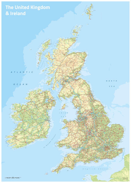
A vibrant and detailed portrait of the British Isles
This full-colour topographic wall map of the UK & Ireland, produced by Oxford Cartographers, one of Britain’s most respected map publishers, is an exceptional way to view the varied landscapes of the isles. Each land height is depicted in contrasting colours, from the low-lying green plains of East Anglia to the rugged peaks of the Scottish Highlands. It is both visually striking and geographically precise, making it one of our favourite maps of the British Isles.
Perfect for schools, universities, offices, or as a stunning decorative piece at home, this map blends cartographic accuracy with rich, colourful design.
🌟 Key Features
-
Topographic Clarity – Land heights shown in a full-colour spectrum for instant readability.
-
Complete Coverage – Includes England, Scotland, Wales, Ireland, Northern Ireland, and the surrounding islands.
-
Cartographic Authority – Created by Oxford Cartographers, renowned for world-class mapping.
-
Versatile Use – Ideal for education, planning, or home decor.
-
Size – 594 mm (w) × 841 mm (h) (A1 format).
-
Made in Australia – Printed to exacting standards using premium materials.
🖼️ Premium Format Options
📜 Paper Map (160 gsm Heavyweight)
-
Crisp, full-colour print.
-
Perfect for framing under glass.
✨ Laminated Map (80 Micron Gloss Encapsulation)
-
Encapsulated in two layers of laminate for strength.
-
Durable, waterproof, and easy to clean.
-
Great for classrooms and offices.
🖼️ Canvas Map (395 gsm Matte Canvas)
-
Printed on museum-grade canvas with pigment-based inks.
-
Rich, tactile finish with long-lasting fade resistance.
-
Transforms your map into a work of art as well as a reference tool.
🪵 Optional Wooden Hang Rails
-
Fitted top and bottom for secure, elegant display.
-
Supplied with a hanging cord for easy mounting.
-
Finished in natural lacquered timber.
⚒️ Please allow up to 10 working days for delivery of hang-railed maps, as they are custom-mounted by our professional framer.
📦 Delivery & Packaging
-
Paper & Laminated Maps – Supplied rolled in a protective map tube.
-
Canvas & Hang-Railed Maps – Carefully packaged and ready for display.
✅ Summary
-
Title: UK & Ireland Topographic Wall Map
-
Publisher: Oxford Cartographers
-
Style: Topographic (coloured land heights)
-
Size: 594 × 841 mm (A1)
-
Formats: Paper, Laminated, Canvas, Canvas/Laminated with Timber Hang Rails
-
Made in Australia
✨ Celebrate the dramatic landscapes and rich geography of the British Isles with this beautifully crafted wall map — perfect for study, teaching, planning, or simply admiring.


