- Australia ▾
- Topographic
▾
- Australia AUSTopo 250k (2025)
- Australia 50k Geoscience maps
- Australia 100k Geoscience maps
- Australia 250k Geoscience maps
- Australia 1:1m Geoscience maps
- New Zealand 50k maps
- New Zealand 250k maps
- New South Wales 25k maps
- New South Wales 50k maps
- New South Wales 100k maps
- Queensland 10k maps
- Queensland 25k maps
- Queensland 50k maps
- Queensland 100k maps
- Western Australia 25k maps
- Western Australia 50k maps
- Western Australia 100k maps
- Compasses
- Software
- GPS Systems
- International ▾
- Wall Maps
▾
- World
- Australia & New Zealand
- Countries, Continents & Regions
- Historical
- Vintage National Geographic
- Australian Capital Territory
- New South Wales
- Northern Territory
- Queensland
- South Australia
- Tasmania
- Victoria
- Western Australia
- Celestial
- Children's
- Mining & Resources
- Wine Maps
- Healthcare
- Postcode Maps
- Electoral Maps
- Nautical ▾
- Flags
▾
- Australian Flag Sets & Banners
- Flag Bunting
- Handwavers
- Australian National Flags
- Aboriginal Flags
- Torres Strait Islander Flags
- International Flags
- Flagpoles & Accessories
- Australian Capital Territory Flags
- New South Wales Flags
- Northern Territory Flags
- Queensland Flags
- South Australia Flags
- Tasmania Flags
- Victoria Flags
- Western Australia Flags
- Gifts ▾
- Globes ▾
Dear valued customer. Please note that our checkout is not supported by old browsers. Please use a recent browser to access all checkout capabilities


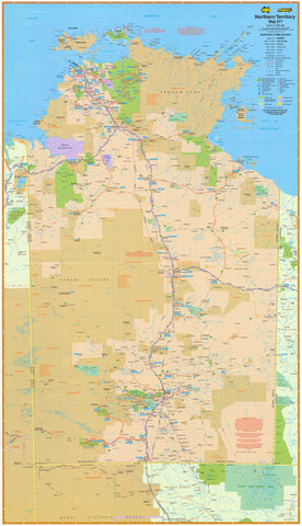
Northern Territory UBD 571 Map 850 x 1480mm Laminated Wall Map
$345.00
or make 4 interest-free payments of
$86.25 AUD
fortnightly with
![]() More info
More info
A Stunning and Functional Wall Map of the Northern Territory – Ideal for Travel, Education & Business Planning
The UBD Northern Territory State Map is a large-format, fully laminated wall map offering a comprehensive overview of Australia’s vast Top End. With a generous size of 850 mm x 1480 mm, this highly detailed map covers towns, cities, homesteads, road networks, and natural reserves, making it an indispensable reference for travellers, planners, educators, and professionals.
Whether you're mapping a journey through Kakadu, planning logistics across the Stuart Highway, or simply looking for a visually engaging representation of the NT, this map is both practical and aesthetically impressive.
🌟 Key Features
| ✅ Feature | 📝 Description |
|---|---|
| 📍 Full Territory Coverage | Covers all of the Northern Territory, from Alice Springs to Darwin, Arnhem Land, and the Barkly Tablelands |
| 🏙️ Detailed Urban & Rural Mapping | Includes towns, cities, homesteads, highways, dual carriageways, and key road routes |
| 🛣️ National Highways & Route Numbers | Clearly marked highways, national/state routes, and distances between centres |
| 🌿 Parks & Protected Areas | Identifies national parks, nature reserves, and Aboriginal land boundaries |
| 🧷 Index & Map Labels | Easy-to-read labels and comprehensive reference grid for practical use in planning or education |
🛡️ Laminated for Durability
Encapsulated in high-quality gloss laminate, this map is:
-
✏️ Dry-erasable – Use whiteboard markers to plan routes or highlight key areas
-
📍 Map-dot friendly – Apply stickers or markers without damaging the surface
-
💧 Tear-resistant & water-resistant – Built for long-term display in any setting
Perfect for classrooms, offices, tour businesses, or anyone needing a reliable and attractive NT reference.
📐 Specifications
| Specification | Details |
|---|---|
| Publisher | UBD Gregory’s |
| Edition | UBD Map 571 |
| Scale | 1:2,000,000 |
| Map Type | Single-sided, laminated wall map |
| Size | 850 mm (W) x 1480 mm (H) |
| Print Material | Printed on high-quality paper and fully laminated (80-micron gloss) |
| Orientation | Portrait |
| Made in | Australia |
🧭 Ideal For
| Use Case | Why It Works |
|---|---|
| 🏞️ Tourism Operators | Showcase routes and regions of the NT for customers |
| 📚 Educators & Students | Use as a large visual aid in geography or Australian studies |
| 🚛 Logistics & Business | Plan freight, travel, or sales zones in regional and remote NT |
| 🏠 Home or Office Decor | A beautiful statement piece for any NT enthusiast or professional |
This oversized wall map of the Northern Territory offers a stunning representation of Australia’s rugged and remote north—ideal for navigation, planning, or simply admiring the vast expanse of one of the world’s most captivating regions.
Frequently Asked Questions
What are the dimensions of the Northern Territory UBD 571 Map 850 x 1480mm Laminated Wall Map?
Mapworld wall maps range from standard 700×1000mm to large-format 1000×1430mm Supermaps. The exact dimensions for this map are shown in the product title. Where multiple sizes are available, select your preferred size when adding to cart.
Is this wall map available laminated?
Many Mapworld wall maps are available in paper, laminated, or framed finishes. Check the product options when adding to cart. Laminated maps are wipe-clean and more durable.
Is this the latest edition?
Mapworld stocks the most current editions available from all publishers. Edition year is shown in the product title where applicable. Mapworld updates its catalogue as new editions are released.
Can I write on or pin this wall map?
Laminated wall maps can be written on with whiteboard markers and wiped clean. Paper maps can be pinned on a corkboard. Choose a laminated option for a writeable surface.
Does Mapworld ship the Northern Territory UBD 571 Map 850 x 1480mm Laminated Wall Map across Australia?
Yes, Mapworld ships Australia-wide. Standard shipping is a flat $7 rate, with free standard shipping on orders over $75. Express options are available at checkout. Most orders placed before 2pm AEST on weekdays are dispatched same day.
Related Items


© 2026 Mapworld. Website designed by Genie Media
X