- Australia ▾
- Topographic
▾
- Australia AUSTopo 250k (2025)
- Australia 50k Geoscience maps
- Australia 100k Geoscience maps
- Australia 250k Geoscience maps
- Australia 1:1m Geoscience maps
- New Zealand 50k maps
- New Zealand 250k maps
- New South Wales 25k maps
- New South Wales 50k maps
- New South Wales 100k maps
- Queensland 10k maps
- Queensland 25k maps
- Queensland 50k maps
- Queensland 100k maps
- Western Australia 25k maps
- Western Australia 50k maps
- Western Australia 100k maps
- Compasses
- Software
- GPS Systems
- International ▾
- Wall Maps
▾
- World
- Australia & New Zealand
- Countries, Continents & Regions
- Historical
- Vintage National Geographic
- Australian Capital Territory
- New South Wales
- Northern Territory
- Queensland
- South Australia
- Tasmania
- Victoria
- Western Australia
- Celestial
- Children's
- Mining & Resources
- Wine Maps
- Healthcare
- Postcode Maps
- Electoral Maps
- Nautical ▾
- Flags
▾
- Australian Flag Sets & Banners
- Flag Bunting
- Handwavers
- Australian National Flags
- Aboriginal Flags
- Torres Strait Islander Flags
- International Flags
- Flagpoles & Accessories
- Australian Capital Territory Flags
- New South Wales Flags
- Northern Territory Flags
- Queensland Flags
- South Australia Flags
- Tasmania Flags
- Victoria Flags
- Western Australia Flags
- Gifts ▾
- Globes ▾
Dear valued customer. Please note that our checkout is not supported by old browsers. Please use a recent browser to access all checkout capabilities


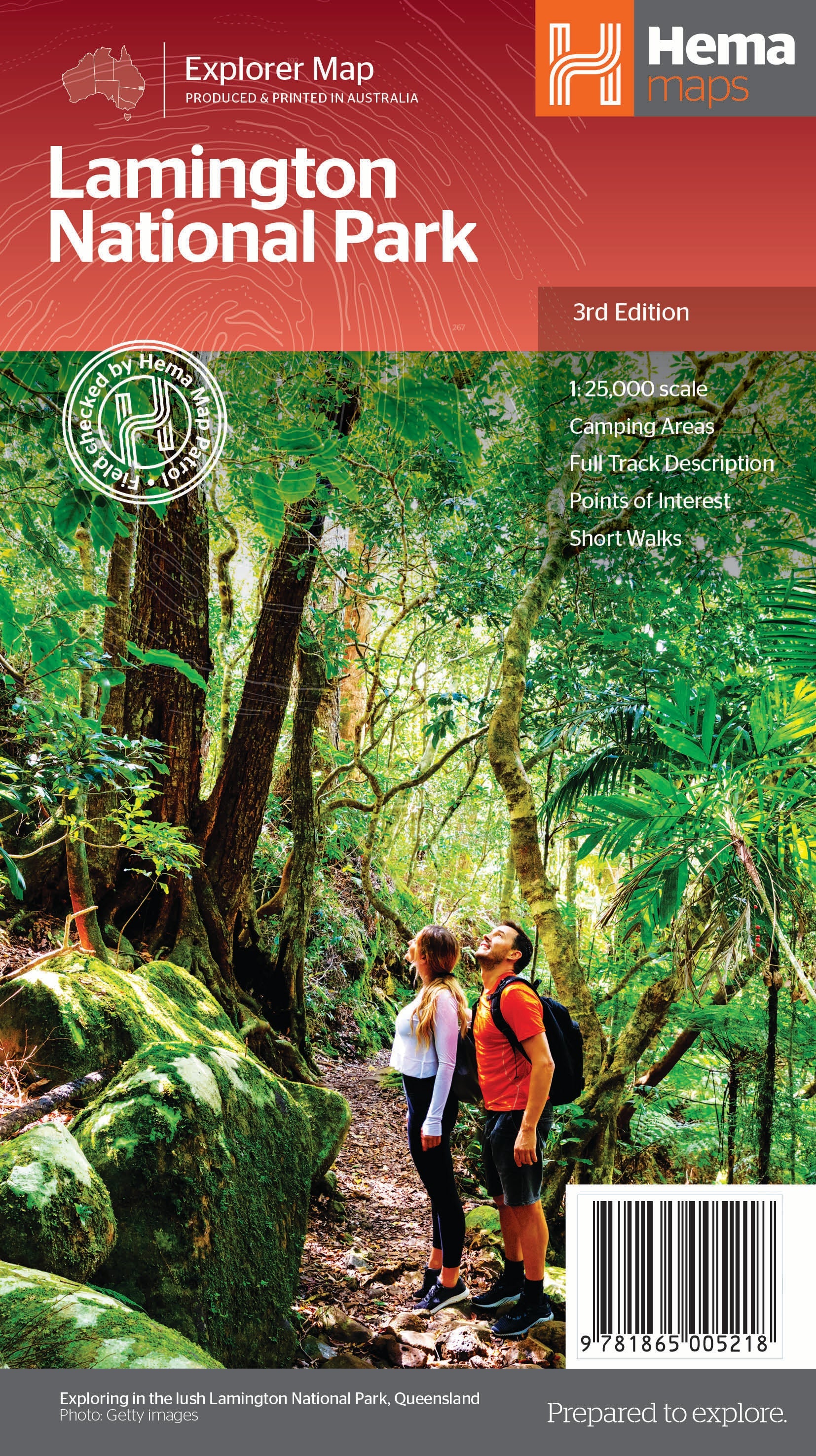
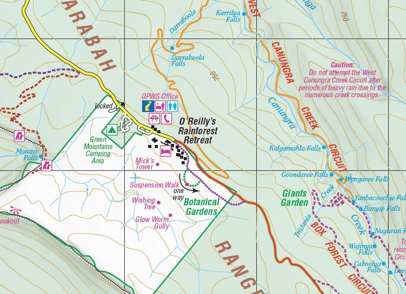
Lamington National Park map by Hema Maps
$14.95
Afterpay is only available for orders between $50.00 and $1000.00 More info
Walking Track Guide • Topographic Detail • Trail Descriptions Included
Covers: Binna Burra, Green Mountains, Border Track, Caves Circuit & More
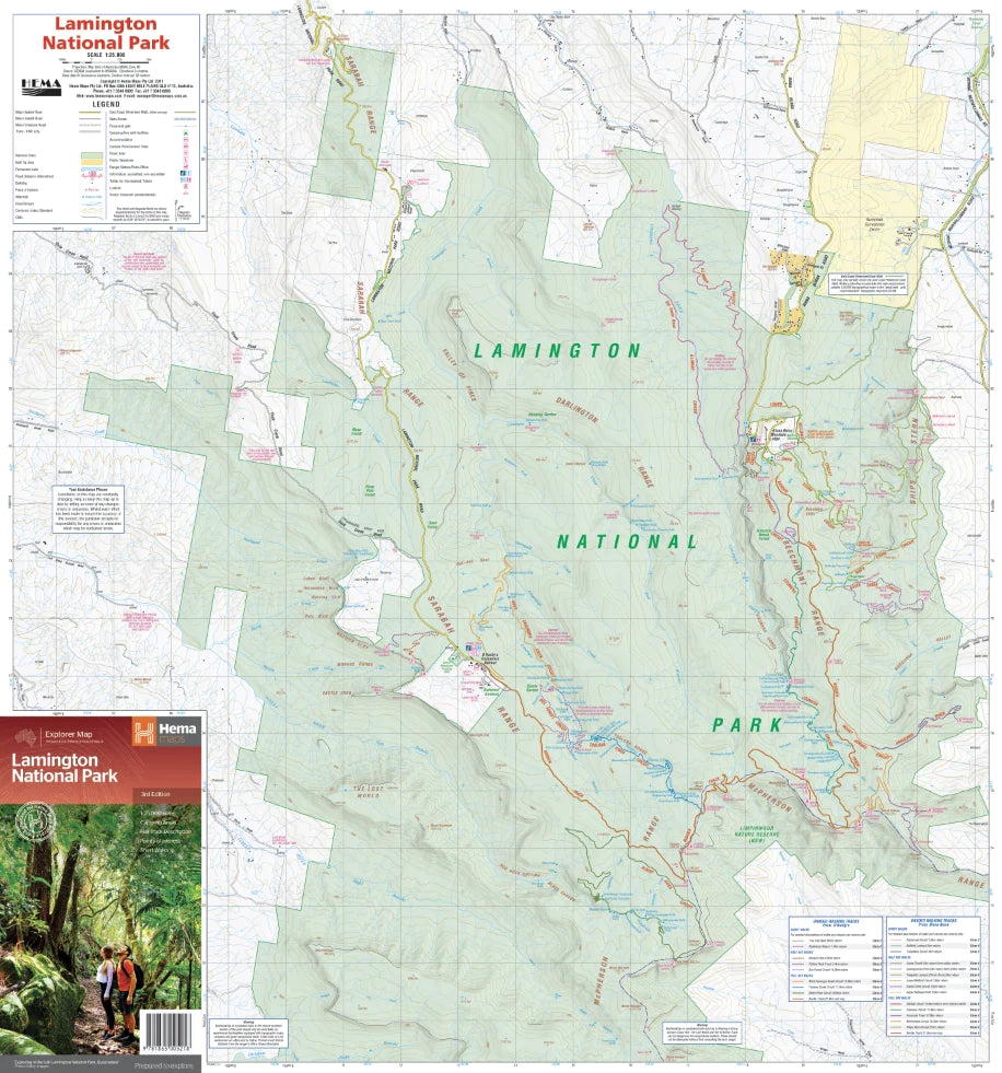
Scale: 1:25,000 | Size: 700 mm x 1000 mm | ISBN: 9781865005218
Step into the heart of Queensland’s rainforest wilderness with the Lamington National Park Map by Hema Maps, your trusted trail companion for exploring one of Australia’s most treasured natural landscapes. Located in southeast Queensland, Lamington National Park forms part of the UNESCO World Heritage-listed Gondwana Rainforests, home to ancient Antarctic beech trees, hidden waterfalls, and rare wildlife including the iconic Albert’s lyrebird.
Designed for walkers, campers, and nature lovers, this 14th Edition topographic map offers exceptional clarity, updated walking trail information, and in-depth descriptions of the park’s best hikes—ranging from relaxing short walks to challenging full-day treks.
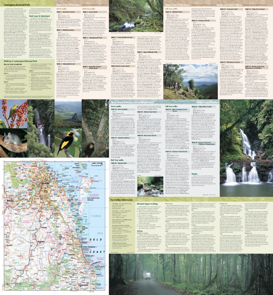
🥾 Track Every Trail – 24 Walks Described in Detail
This map includes expert descriptions of 24 walking tracks, grouped by duration and difficulty to help you plan your ideal experience:
🟢 Short Walks (up to 1 hour)
-
Easy-access trails for families and casual visitors
-
Examples: Rainforest Circuit, Centenary Track, Python Rock Lookout
🟡 Half-Day Hikes (1.5–4 hours)
-
Moderate walks with waterfalls, lookouts, and wildlife encounters
-
Examples: Moran’s Falls, Caves Circuit, Toolona Creek Circuit
🔴 Full-Day Adventures (5–7 hours)
-
For experienced hikers ready to explore the remote rainforest
-
Highlight: Border Track from Binna Burra to O’Reilly’s
Each track entry includes:
-
🚶♂️ Trail name and route overview
-
🕒 Time required to complete
-
📊 Classification of difficulty (easy/moderate/difficult)
-
📍 Notable features along the way (lookouts, creeks, flora/fauna)
🗺️ Map Features
| Feature | Description |
|---|---|
| 🥾 Track Descriptions | 24 walks with detailed time and difficulty info |
| 🗺️ Topographic Mapping | 1:25,000 scale for high-resolution terrain detail |
| 🌿 Area Coverage | Binna Burra, Green Mountains, Coomera Valley, Border Track & surrounds |
| 📌 Points of Interest | Includes campsites, creeks, picnic areas, waterfalls, scenic lookouts |
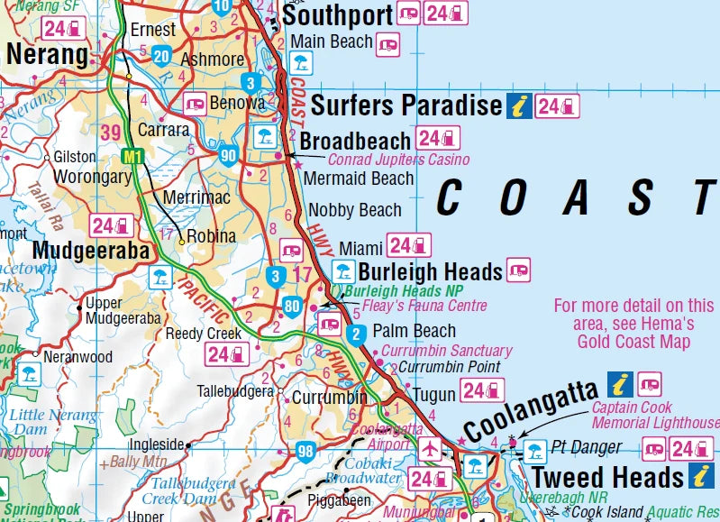
| 🚗 Regional Access Map | Shows road connections from Brisbane, Gold Coast, and Canungra |
| 🚻 Facilities & Services | Toilets, car parks, rest areas, ranger stations marked |
| 📞 Useful Contacts | Emergency and visitor centre phone numbers included |
| 📷 Regional Images | Features photos of Lamington’s landscapes to inspire your visit |
📐 Product Specifications
| Specification | Detail |
|---|---|
| Title | Lamington National Park Map |
| Publisher | Hema Maps |
| Edition | 14th Edition |
| Scale | 1:25,000 |
| Format | Folded topographic hiking map |
| Size | 700 mm (W) x 1000 mm (H) (unfolded) |
| ISBN | 9781865005218 |
| Full colour with shaded relief and contours |
🎯 Perfect For
-
🥾 Bushwalkers & hikers – from weekend warriors to experienced trekkers
-
📸 Wildlife watchers & photographers – find the best lookouts and birding spots
-
🏕️ Campers & caravaners – locate campsites, picnic areas, and facilities
-
🧭 Navigation learners – excellent tool for compass and map-reading skills
-
🌿 Eco-tourists & students – learn about this unique subtropical rainforest region
🛡️ Laminated & Canvas Versions Available
Want more durability for field use or wall display?
Waterproof, tear-resistant 80-micron gloss lamination
Reusable with whiteboard markers—perfect for wet-weather hikes or repeated use
💬 Why Choose Hema Maps?
With over 30 years of mapping expertise and a reputation for field-verified accuracy, Hema Maps are the gold standard for Australian adventurers. Their national park series is trusted by rangers, guides, and hikers alike for its clarity, dependability, and trail knowledge.
🛒 Explore the Trails of Lamington Today
From misty peaks and dense rainforest to tumbling waterfalls and scenic lookouts, Lamington National Park is one of Queensland’s most inspiring natural destinations. Don’t miss a thing—take the Hema Lamington National Park Map on your next escape and let the forest reveal its wonders.
📦 Add to cart now and prepare for your rainforest adventure.
Frequently Asked Questions
Where can I buy the Lamington National Park map by Hema Maps?
The Lamington National Park map by Hema Maps is available to buy online from Mapworld, Australia's largest map and geographic product retailer, with fast shipping Australia-wide.
Is the Lamington National Park map by Hema Maps in stock at Mapworld?
Mapworld maintains extensive stock across its map range and aims for fast dispatch. Orders placed before 2pm AEST on business days are typically dispatched the same day, with standard and express Australia-wide delivery options available.
What is Mapworld's returns policy?
Mapworld accepts returns on undamaged items in original condition. Contact Mapworld within 90 days of purchase to arrange a return or exchange.
Does Mapworld ship the Lamington National Park map by Hema Maps across Australia?
Yes, Mapworld ships Australia-wide. Standard shipping is a flat $7 rate, with free standard shipping on orders over $75. Express options are available at checkout. Most orders placed before 2pm AEST on weekdays are dispatched same day.
Related Items

© 2026 Mapworld. Website designed by Genie Media
X