- Australia ▾
- Topographic
▾
- Australia AUSTopo 250k (2025)
- Australia 50k Geoscience maps
- Australia 100k Geoscience maps
- Australia 250k Geoscience maps
- Australia 1:1m Geoscience maps
- New Zealand 50k maps
- New Zealand 250k maps
- New South Wales 25k maps
- New South Wales 50k maps
- New South Wales 100k maps
- Queensland 10k maps
- Queensland 25k maps
- Queensland 50k maps
- Queensland 100k maps
- Compasses
- Software
- GPS Systems
- Orienteering
- International ▾
- Wall Maps
▾
- World
- Australia & New Zealand
- Countries, Continents & Regions
- Historical
- Vintage National Geographic
- Australian Capital Territory
- New South Wales
- Northern Territory
- Queensland
- South Australia
- Tasmania
- Victoria
- Western Australia
- Celestial
- Children's
- Mining & Resources
- Wine Maps
- Healthcare
- Postcode Maps
- Electoral Maps
- Nautical ▾
- Flags
▾
- Australian Flag Sets & Banners
- Flag Bunting
- Handwavers
- Australian National Flags
- Aboriginal Flags
- Torres Strait Islander Flags
- International Flags
- Flagpoles & Accessories
- Australian Capital Territory Flags
- New South Wales Flags
- Northern Territory Flags
- Queensland Flags
- South Australia Flags
- Tasmania Flags
- Victoria Flags
- Western Australia Flags
- Gifts ▾
- Globes ▾
Dear valued customer. Please note that our checkout is not supported by old browsers. Please use a recent browser to access all checkout capabilities


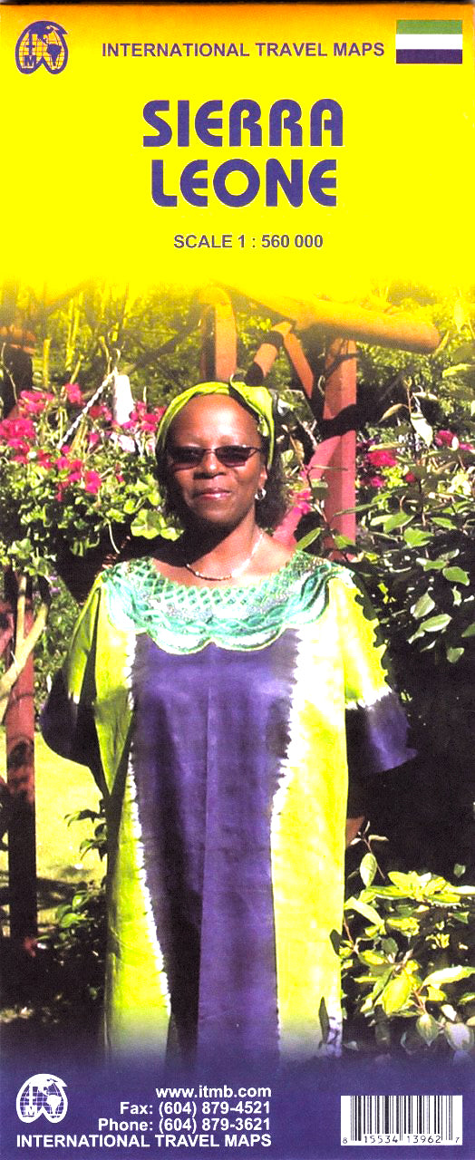
Sierra Leone ITMB Map
$24.95
Afterpay is only available for orders between $50.00 and $1000.00 More info
Scale 1:560,000 | Size 680 x 990 mm | Folded Paper or Laminated Wall Map
Explore West Africa’s Hidden Gem — Updated, Accurate, and Ready for Adventure
Immerse yourself in the landscapes, history, and roadways of Sierra Leone with this meticulously crafted travel map from International Travel Maps (ITMB). This single-sided, large-format map offers one of the most current and accurate portrayals of Sierra Leone available today — a country once called the “Athens of West Africa,” now re-emerging as a destination of cultural and ecological wonder.
This new edition was produced with on-the-ground input from the Sierra Leone Tourism Authority and features a comprehensive street map of the capital, Freetown, making it a valuable tool for independent travellers, researchers, aid workers, educators, and anyone fascinated by the geography and politics of West Africa.
🗺️ Map Features At a Glance
| Feature | Details |
|---|---|
| Scale | 1:560,000 — Ideal for regional travel and planning |
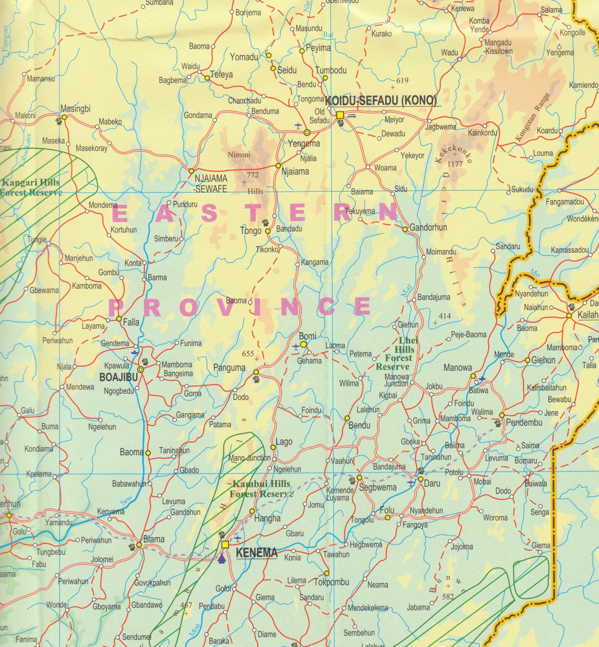
| Coverage | Full national coverage with regional detail |
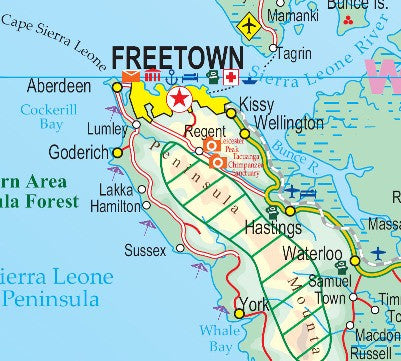
| Inset Map | Includes a detailed street map of Freetown |
| Transport Network | Main roads, secondary roads, tracks, ferry routes, airfields, railroads, and border crossings |
| Topography | Terrain shading, rivers, coastlines, and relief features |
| Cultural Sites | Points of interest, archaeological sites, parks, museums, ruins, mosques, churches, and beaches |
| Travel Services | Locations of gas stations, campsites, hospitals, hostels, and accommodation options |
| Political Boundaries | Clear display of international borders and key towns |
| Legend | Multilingual, with English prominently used throughout |
Formats & Finish Options
Choose the format that best suits your needs:
Folded Paper Map
A compact, portable version perfect for fieldwork, gloveboxes, backpacks, or planning on the go.
Laminated Wall Map
Professionally laminated with 80-micron gloss laminate on both sides, allowing you to:
-
Use whiteboard markers for notes and plotting routes
-
Apply map dots to track visits or research areas
-
Resist wear, stains, and water damage for long-term use
Note: Folded maps are flattened prior to lamination. Some subtle fold lines may remain.
Why This Map Matters
-
Trusted Cartography: Produced by ITMB, a world leader in mapping remote and under-represented regions
-
Updated Insights: Revised with current road and infrastructure data supplied directly by the Sierra Leone Tourism Authority
-
Practical & Political Relevance: A valuable tool for aid workers, researchers, journalists, and policy professionals
-
Educational Value: Helps contextualise Sierra Leone’s geography, post-conflict recovery, and growing tourism industry
-
Durable and Display-Worthy: Whether folded, laminated, or hang-railed — this map is built to last
🎯 Perfect For
-
Humanitarian and development professionals
-
Adventure travellers and overlanders
-
Academic institutions and libraries
-
African studies programs and NGOs
-
Cartographic enthusiasts and collectors
-
Gift buyers seeking meaningful, educational pieces
Specifications
| Attribute | Details |
|---|---|
| Publisher | International Travel Maps (ITMB) |
| Edition | Latest edition |
| Format | Folded, Laminated, or Laminated with Hang Rails |
| Size | 680 mm (W) x 990 mm (H) |
| Printed On | High-quality paper; laminated versions in 80-micron gloss laminate |
| Made | Printed in Canada, assembled in Australia |
Rediscover Sierra Leone — a land of vibrant traditions, rolling hills, unspoiled beaches, and resilient communities. This map doesn’t just guide you — it tells the story of a nation in transformation.
Add to cart now and choose the format that fits your journey.
Frequently Asked Questions
Where can I buy the Sierra Leone ITMB Map?
The Sierra Leone ITMB Map is available to buy online from Mapworld, Australia's largest map and geographic product retailer, with fast shipping Australia-wide.
Is the Sierra Leone ITMB Map in stock at Mapworld?
Mapworld maintains extensive stock across its map range and aims for fast dispatch. Orders placed before 2pm AEST on business days are typically dispatched the same day, with standard and express Australia-wide delivery options available.
What is Mapworld's returns policy?
Mapworld accepts returns on undamaged items in original condition. Contact Mapworld within 90 days of purchase to arrange a return or exchange.
Does Mapworld ship the Sierra Leone ITMB Map across Australia?
Yes, Mapworld ships Australia-wide. Standard shipping is a flat $7 rate, with free standard shipping on orders over $75. Express options are available at checkout. Most orders placed before 2pm AEST on weekdays are dispatched same day.
Related Items


© 2026 Mapworld. Website designed by Genie Media
X