- Australia ▾
- Topographic
▾
- Australia AUSTopo 250k (2025)
- Australia 50k Geoscience maps
- Australia 100k Geoscience maps
- Australia 250k Geoscience maps
- Australia 1:1m Geoscience maps
- New Zealand 50k maps
- New Zealand 250k maps
- New South Wales 25k maps
- New South Wales 50k maps
- New South Wales 100k maps
- Queensland 10k maps
- Queensland 25k maps
- Queensland 50k maps
- Queensland 100k maps
- Compasses
- Software
- GPS Systems
- Orienteering
- International ▾
- Wall Maps
▾
- World
- Australia & New Zealand
- Countries, Continents & Regions
- Historical
- Vintage National Geographic
- Australian Capital Territory
- New South Wales
- Northern Territory
- Queensland
- South Australia
- Tasmania
- Victoria
- Western Australia
- Celestial
- Children's
- Mining & Resources
- Wine Maps
- Healthcare
- Postcode Maps
- Electoral Maps
- Nautical ▾
- Flags
▾
- Australian Flag Sets & Banners
- Flag Bunting
- Handwavers
- Australian National Flags
- Aboriginal Flags
- Torres Strait Islander Flags
- International Flags
- Flagpoles & Accessories
- Australian Capital Territory Flags
- New South Wales Flags
- Northern Territory Flags
- Queensland Flags
- South Australia Flags
- Tasmania Flags
- Victoria Flags
- Western Australia Flags
- Gifts ▾
- Globes ▾
Dear valued customer. Please note that our checkout is not supported by old browsers. Please use a recent browser to access all checkout capabilities


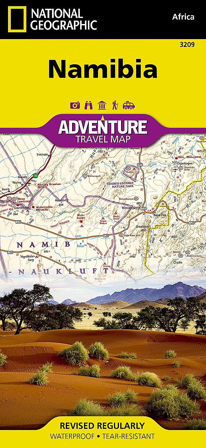
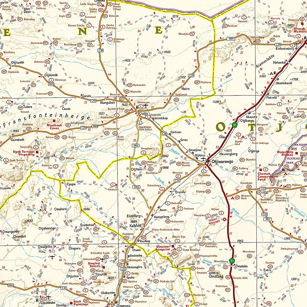
Namibia Adventure Travel Map by National Geographic
$27.95
Afterpay is only available for orders between $50.00 and $1000.00 More info
Map No.: 3209
Format: Folded Adventure Map
Map Scale: 1:1,100,000 (approx.)
Size (Unfolded): 965 x 660 mm
Size (Folded): 235 x 108 mm
Printed On: Waterproof & tear-resistant synthetic paper
🌍 Discover Namibia with Confidence
Designed for explorers who seek both detail and durability, National Geographic’s Namibia Adventure Travel Map offers an expertly crafted view of one of Africa’s most breathtaking and remote travel destinations. Whether you're crossing the windswept dunes of the Namib, tracking wildlife through Etosha, or navigating vast desert highways, this map is your ideal companion.
Printed on ultra-durable, waterproof, tear-resistant synthetic stock, it’s ready for the challenges of desert travel, rugged 4WD routes, and the unpredictable conditions of adventure touring.
🧭 Map Features & Highlights
-
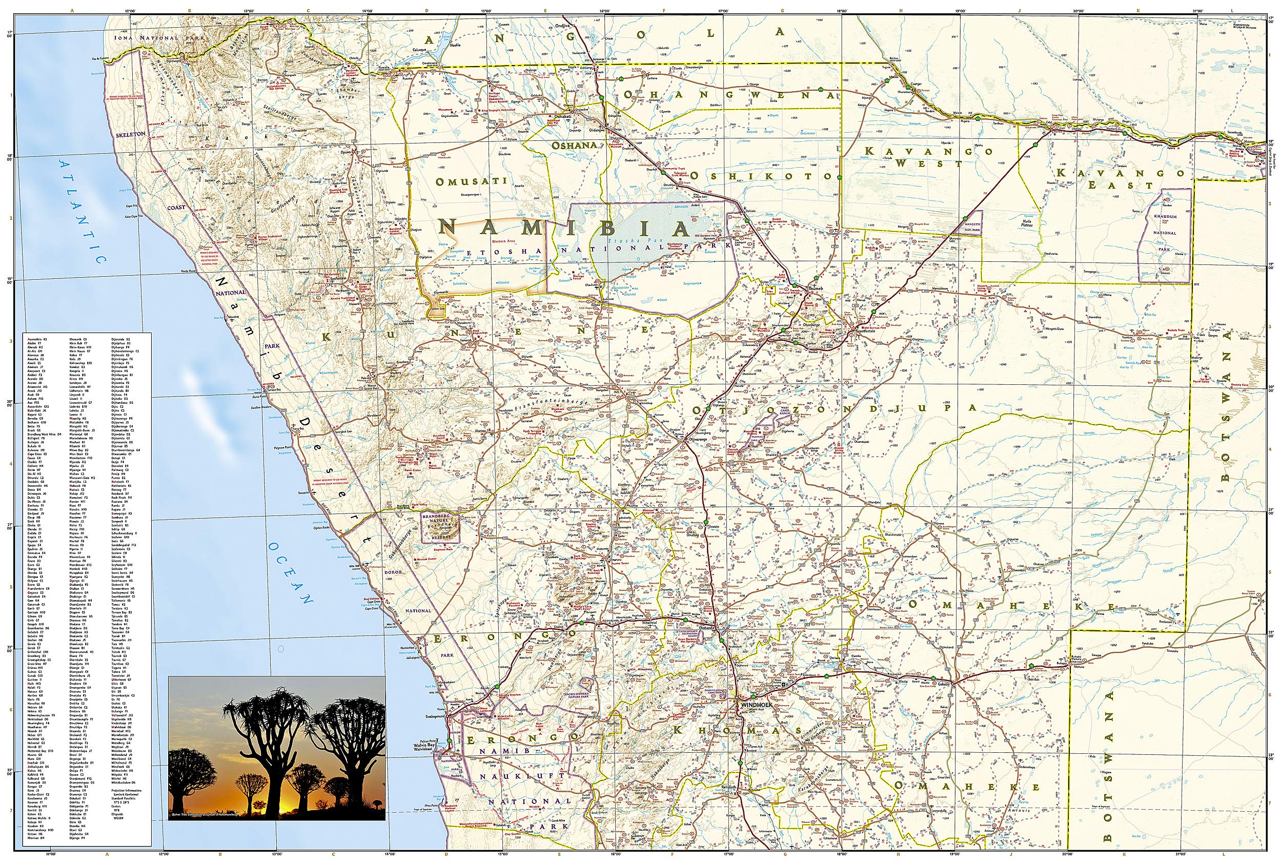
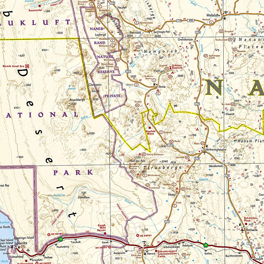
🛣️ Detailed Road Network
Includes highways, secondary roads, 4WD tracks, and remote access routes – all with clear road classifications and distances between points. -
🏕️ Accommodation & Campgrounds
Hundreds of private lodges, campsites, and government rest camps are clearly marked to assist with overnight planning. -
🐘 Tourist & Wildlife Destinations
Highlights include Etosha National Park, Skeleton Coast, Namib-Naukluft, Damaraland, and more – with icons denoting wildlife viewing, cultural sites, scenic viewpoints, and protected areas. -
🧳 Cities, Towns & Infrastructure
Includes all major towns and cities with a user-friendly place index, as well as airstrips, border posts, and key landmarks. -
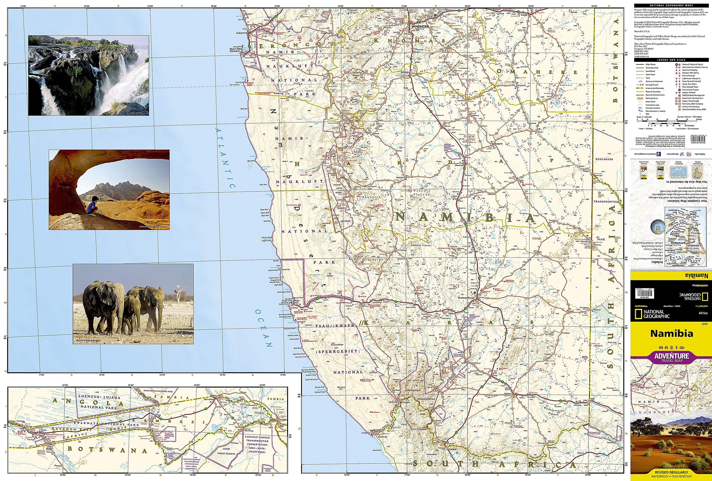
🗺️ Two-Sided Map Coverage
-
Front side: Northern Namibia, featuring Skeleton Coast National Park and overlaps to include Windhoek.
-
Back side: Southern Namibia, including the Namib-Naukluft National Park, Tsau//Khaeb (Sperrgebiet), and the border with South Africa.
-
🌐 Why Choose a National Geographic Adventure Map?
Unlike traditional road maps, Adventure Maps are designed for cultural immersion and off-grid discovery. These maps offer:
-
🌱 Ecological detail – national parks, biospheres, desert zones, and riverbeds
-
🗿 Cultural and historic sites – petroglyphs, mission ruins, shipwrecks, and more
-
🚩 Adventure-focused content – for hiking, wildlife watching, camping, and overlanding
Whether you're a self-drive explorer, overlander, ecotourist, or guidebook-savvy traveller, this map is your practical tool and visual guide to the wild landscapes of Namibia.
📦 Product Summary
| Feature | Details |
|---|---|
| Publisher | National Geographic |
| Map Title | Namibia Adventure Travel Map |
| Map Number | 3209 |
| Scale | Approx. 1:1,100,000 |
| Size (Unfolded) | 965 mm x 660 mm |
| Size (Folded) | 235 mm x 108 mm |
| Format | Folded, double-sided |
| Material | Synthetic waterproof & tear-resistant paper |
| Index | Yes – Includes cities, towns, camps, and POIs |
| Tourist Info Included | Yes – Lodges, parks, cultural and historic sites |
🧭 Perfect For:
-
🚙 Overlanders & road trippers
-
🏞️ Wildlife and eco-tourists
-
🎒 Backpackers and solo travellers
-
🗺️ Map collectors and travel enthusiasts
-
📚 Tour guides and travel planners
Experience Namibia with the confidence and clarity of National Geographic cartography – trusted by travellers around the globe. Built to last and rich with information, this map is more than just a guide — it’s your gateway to one of the world’s last great wilderness frontiers.
Frequently Asked Questions
Where can I buy the Namibia Adventure Travel Map by National Geographic?
The Namibia Adventure Travel Map by National Geographic is available to buy online from Mapworld, Australia's largest map and geographic product retailer, with fast shipping Australia-wide.
Is the Namibia Adventure Travel Map by National Geographic in stock at Mapworld?
Mapworld maintains extensive stock across its map range and aims for fast dispatch. Orders placed before 2pm AEST on business days are typically dispatched the same day, with standard and express Australia-wide delivery options available.
What is Mapworld's returns policy?
Mapworld accepts returns on undamaged items in original condition. Contact Mapworld within 90 days of purchase to arrange a return or exchange.
Does Mapworld ship the Namibia Adventure Travel Map by National Geographic across Australia?
Yes, Mapworld ships Australia-wide. Standard shipping is a flat $7 rate, with free standard shipping on orders over $75. Express options are available at checkout. Most orders placed before 2pm AEST on weekdays are dispatched same day.
Related Items


© 2026 Mapworld. Website designed by Genie Media
X