- Australia ▾
- Topographic
▾
- Australia AUSTopo 250k (2025)
- Australia 50k Geoscience maps
- Australia 100k Geoscience maps
- Australia 250k Geoscience maps
- Australia 1:1m Geoscience maps
- New Zealand 50k maps
- New Zealand 250k maps
- New South Wales 25k maps
- New South Wales 50k maps
- New South Wales 100k maps
- Queensland 10k maps
- Queensland 25k maps
- Queensland 50k maps
- Queensland 100k maps
- Compasses
- Software
- GPS Systems
- Orienteering
- International ▾
- Wall Maps
▾
- World
- Australia & New Zealand
- Countries, Continents & Regions
- Historical
- Vintage National Geographic
- Australian Capital Territory
- New South Wales
- Northern Territory
- Queensland
- South Australia
- Tasmania
- Victoria
- Western Australia
- Celestial
- Children's
- Mining & Resources
- Wine Maps
- Healthcare
- Postcode Maps
- Electoral Maps
- Nautical ▾
- Flags
▾
- Australian Flag Sets & Banners
- Flag Bunting
- Handwavers
- Australian National Flags
- Aboriginal Flags
- Torres Strait Islander Flags
- International Flags
- Flagpoles & Accessories
- Australian Capital Territory Flags
- New South Wales Flags
- Northern Territory Flags
- Queensland Flags
- South Australia Flags
- Tasmania Flags
- Victoria Flags
- Western Australia Flags
- Gifts ▾
- Globes ▾
Dear valued customer. Please note that our checkout is not supported by old browsers. Please use a recent browser to access all checkout capabilities


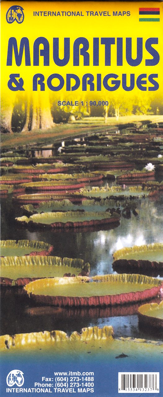
Mauritius & Rodrigues ITMB Map
$45.00
Afterpay is only available for orders between $50.00 and $1000.00 More info
🏝️ Mauritius & Rodrigues ITMB Travel Map
Scale: 1:90,000 (Mauritius) | Inset of Rodrigues
Size: 680 mm × 990 mm
Format: Folded Paper or Optional Laminated Finish
Publisher: ITMB (International Travel Maps)
Printed in Canada
🗺️ Explore the Islands of Paradise – Mauritius & Rodrigues
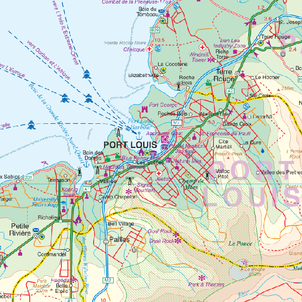
This beautifully designed Mauritius & Rodrigues map by ITMB is a practical and elegant navigation tool for anyone planning a journey to these captivating Indian Ocean islands. Whether you're preparing for a luxurious beach getaway, a nature-focused eco-tour, or simply want to understand the geography and culture of this tropical region, this map provides rich, accurate cartography with a warm visual style.
This is one of ITMB’s newest and most anticipated titles, and it highlights not just the major coastal resorts but also the internal road network, local villages, natural parks, and other cultural landmarks that make these islands so unique.
🌴 Map Features:
-
Full country coverage of Mauritius at 1:90,000
-
Inset map of Rodrigues Island, northeast of Mauritius
-
🛣️ Detailed road network, including coastal roads and rural routes
-
🏖️ All major beach resorts, points of interest, scenic attractions, and natural parks
-
🧭 Topographic elements like elevation shading and vegetation zones
-
🌐 Dual-language place names (French & English), reflecting local heritage
-
🏘️ Towns, villages, hotels, cultural sites, airports, and ferry connections included
Whether you're flying into Port Louis or planning to snorkel off the Rodrigues reef, this map offers everything you need for an enriching travel experience.
🛡️ Optional Laminated Version – Durable & Reusable
Upgrade to our laminated edition for extended durability and interactive use:
-
💧 Waterproof, tear-resistant, and stain-proof
-
✍️ Use whiteboard markers to chart travel routes or annotate plans
-
📍 Apply map dots or travel stickers without damaging the surface
-
🧳 Perfect for tour guides, travel agents, or repeat travelers
Laminated maps are prepared by flattening the original folded version and encapsulating it in premium 80-micron gloss laminate. Minor fold lines may still be visible.
📐 Specifications
| Feature | Details |
|---|---|
| Map Title | Mauritius & Rodrigues |
| Publisher | ITMB (International Travel Maps) |
| Scale | 1:90,000 (Mauritius) |
| Inset | Rodrigues Island |
| Size | 680 mm × 990 mm |
| Format | Folded Paper Map or Optional Laminate |
| Lamination | 80-micron gloss encapsulation |
| Printed In | Canada |
👤 Who Is This Map For?
-
✈️ Travelers and holidaymakers visiting Mauritius or Rodrigues
-
🧭 Island explorers who prefer self-guided discovery
-
🌴 Luxury resort guests who want to venture beyond the beachfront
-
📚 Educators, students, and researchers focused on Indian Ocean geography
-
🏖️ Tour planners or agents who need accurate, reusable reference tools
📦 Order on Demand
Please allow 7–10 business days for delivery of laminated editions.
Discover the full scope of island life—from coral reefs and lagoons to volcanic peaks and Creole culture—with this essential Mauritius & Rodrigues travel map from ITMB
Frequently Asked Questions
Where can I buy the Mauritius & Rodrigues ITMB Map?
The Mauritius & Rodrigues ITMB Map is available to buy online from Mapworld, Australia's largest map and geographic product retailer, with fast shipping Australia-wide.
Is the Mauritius & Rodrigues ITMB Map in stock at Mapworld?
Mapworld maintains extensive stock across its map range and aims for fast dispatch. Orders placed before 2pm AEST on business days are typically dispatched the same day, with standard and express Australia-wide delivery options available.
What is Mapworld's returns policy?
Mapworld accepts returns on undamaged items in original condition. Contact Mapworld within 90 days of purchase to arrange a return or exchange.
Does Mapworld ship the Mauritius & Rodrigues ITMB Map across Australia?
Yes, Mapworld ships Australia-wide. Standard shipping is a flat $7 rate, with free standard shipping on orders over $75. Express options are available at checkout. Most orders placed before 2pm AEST on weekdays are dispatched same day.
Related Items


© 2026 Mapworld. Website designed by Genie Media
X