- Australia ▾
- Topographic
▾
- Australia AUSTopo 250k (2024)
- Australia 50k Geoscience maps
- Australia 100k Geoscience maps
- Australia 250k Geoscience maps
- Australia 1.1m Geoscience maps
- New Zealand 50k maps
- New Zealand 250k maps
- New South Wales 25k maps
- New South Wales 50k maps
- New South Wales 100k maps
- Queensland 10k maps
- Queensland 25k maps
- Queensland 50k maps
- Queensland 100k maps
- Compasses
- Software
- GPS Systems
- Orienteering
- International ▾
- Wall Maps
▾
- World
- Australia & New Zealand
- Countries, Continents & Regions
- Historical
- Vintage National Geographic
- Australian Capital Territory
- New South Wales
- Northern Territory
- Queensland
- South Australia
- Tasmania
- Victoria
- Western Australia
- Celestial
- Children's
- Mining & Resources
- Wine Maps
- Healthcare
- Postcode Maps
- Electoral Maps
- Nautical ▾
- Flags
▾
- Australian Flag Sets & Banners
- Flag Bunting
- Handwavers
- Australian National Flags
- Aboriginal Flags
- Torres Strait Islander Flags
- International Flags
- Flagpoles & Accessories
- Australian Capital Territory Flags
- New South Wales Flags
- Northern Territory Flags
- Queensland Flags
- South Australia Flags
- Tasmania Flags
- Victoria Flags
- Western Australia Flags
- Gifts ▾
- Globes ▾
Dear valued customer. Please note that our checkout is not supported by old browsers. Please use a recent browser to access all checkout capabilities
Horn of Africa Atlas of the World, 11th Edition, National Geographic Wall Map
$69.95
or make 4 interest-free payments of
$17.49 AUD
fortnightly with
![]() More info
More info
National Geographic | Atlas of the World, 11th Edition
Available Sizes:
📏 Standard: 790 x 610 mm
🗺️ Supermap: 915 x 1197 mm
Where geography, politics, and precision converge—National Geographic brings the Horn of Africa into focus.
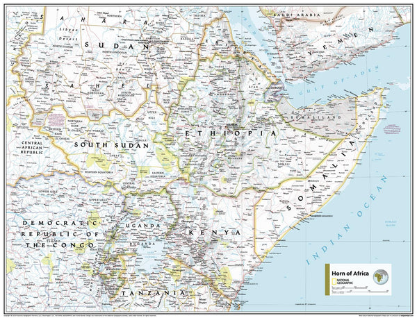
Explore the crossroads of Africa and the Middle East with this beautifully crafted Horn of Africa Wall Map, drawn from National Geographic’s 11th Edition Atlas of the World. This map combines stunning physical detail and clear political boundaries to offer a complete, easy-to-read view of one of the world’s most strategically important regions.
Whether you’re an educator, student, policy researcher, or curious traveller, this map offers both an insightful reference and an elegant display piece. It’s ideal for classrooms, libraries, offices, or homes—anywhere global awareness matters.
🧭 Map Features
-
🌍 Countries covered: Somalia, Ethiopia, Eritrea, Djibouti, Sudan, South Sudan, and parts of Kenya, Yemen, and the Red Sea
-
🏞️ Physical features: Mountains, rivers, deserts, highlands, coastlines, and shaded ocean relief
-
🗺️ Political detail: Country boundaries, capitals, major cities, and key infrastructure
-
🌊 Vibrant blue oceans and colour-coded terrain, presented in National Geographic’s signature style
-
📐 Projection: Transverse Mercator – ideal for nautical and regional accuracy
-
📚 Source: Taken directly from National Geographic's Atlas of the World, 11th Edition
Combines the clarity of a political map with the depth of a physical map—designed for understanding, learning, and exploration.
🎓 Perfect For:
-
Geography and global studies classrooms
-
Environmental science or regional history courses
-
International relations and policy discussions
-
Decorating a study, office, or research space
-
Anyone with interest in the Horn of Africa’s complex landscape
🖼️ Available in Three Premium Formats
| Format | Material & Finish | Best For |
|---|---|---|
| Paper | 160gsm heavyweight matte paper | For framing under glass in educational or home settings |
| Laminated | Fully encapsulated in 80-micron gloss laminate – waterproof, wipeable, and compatible with whiteboard markers | Ideal for classrooms, shared spaces, or frequent handling |
| Canvas | Printed on 395gsm HP Matte Artist’s Canvas using pigment-based inks | A durable, gallery-quality finish for office or library walls |
➕ Optional timber hang rails available for laminated and canvas formats.
🪵 Optional Timber Hang Rails – Display-Ready Presentation
Upgrade your laminated or canvas map with our handcrafted hang rails:
-
🪵 Natural timber rails, lacquered with a smooth satin finish
-
🧵 Corded top rail for effortless hanging
-
🖐️ Professionally assembled by our framing team
-
⏳ Please allow up to 10 working days for delivery of rail-mounted maps
Elevate your map to a polished educational or professional display.
📐 Specifications
| Feature | Details |
|---|---|
| Title | Horn of Africa Wall Map |
| Publisher | National Geographic |
| Edition | Atlas of the World, 11th Edition |
| Map Style | Political and Physical |
| Projection | Transverse Mercator |
| Standard Size | 790 x 610 mm |
| Supermap Size | 915 x 1197 mm |
| Published | 2019 |
| Optional Extras | Timber hang rails (Laminated & Canvas formats only) |
| Print Origin | Printed and finished in Australia |
💡 Why Choose This Map?
🧠 Informative & Easy to Read – Clear boundaries and topography help explain one of the world’s most geopolitically complex regions
📚 Classroom-Ready – A brilliant teaching aid for history, geography, environmental studies, or global affairs
🖼️ Refined Décor – Perfect for scholars, educators, and travellers who want both form and function
🎁 A Thoughtful Gift – For global citizens, researchers, and world explorers
🖨️ Exceptional Quality – Printed using archival pigment inks on professional-grade materials
Let the Horn of Africa Wall Map become your window to a region shaped by geography, culture, and change—rendered in the iconic clarity of National Geographic.
📦 Shipping & Handling
-
📄 Paper & Laminated formats: Ships in 1–2 business days
-
🖼️ Canvas or Timber Rail versions: Please allow 7–10 business days for custom finishing
🛒 Add to Cart – Explore the Horn of Africa in Detail
Bring home a premium-quality map that informs, inspires, and enhances any learning or professional space.


