- Australia ▾
- Topographic
▾
- Australia AUSTopo 250k (2024)
- Australia 50k Geoscience maps
- Australia 100k Geoscience maps
- Australia 250k Geoscience maps
- Australia 1.1m Geoscience maps
- New Zealand 50k maps
- New Zealand 250k maps
- New South Wales 25k maps
- New South Wales 50k maps
- New South Wales 100k maps
- Queensland 10k maps
- Queensland 25k maps
- Queensland 50k maps
- Queensland 100k maps
- Compasses
- Software
- GPS Systems
- Orienteering
- International ▾
- Wall Maps
▾
- World
- Australia & New Zealand
- Countries, Continents & Regions
- Historical
- Vintage National Geographic
- Australian Capital Territory
- New South Wales
- Northern Territory
- Queensland
- South Australia
- Tasmania
- Victoria
- Western Australia
- Celestial
- Children's
- Mining & Resources
- Wine Maps
- Healthcare
- Postcode Maps
- Electoral Maps
- Nautical ▾
- Flags
▾
- Australian Flag Sets & Banners
- Flag Bunting
- Handwavers
- Australian National Flags
- Aboriginal Flags
- Torres Strait Islander Flags
- International Flags
- Flagpoles & Accessories
- Australian Capital Territory Flags
- New South Wales Flags
- Northern Territory Flags
- Queensland Flags
- South Australia Flags
- Tasmania Flags
- Victoria Flags
- Western Australia Flags
- Gifts ▾
- Globes ▾
Dear valued customer. Please note that our checkout is not supported by old browsers. Please use a recent browser to access all checkout capabilities
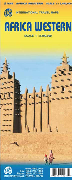
Africa Western ITMB Map
$24.95
Afterpay is only available for orders between $50.00 and $1000.00 More info
Cross-continental exploration starts here. The Western Africa ITMB Map is a modern, meticulously updated travel map covering the dynamic and diverse region from southern Spain and Morocco to the Bight of Benin and beyond. Whether you're planning a trans-African journey, studying regional geography, or simply fascinated by one of the world’s most complex and colourful regions, this is the essential map for your collection.
🧭 Map Coverage & Highlights
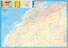
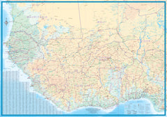
This double-sided map offers an expansive and highly detailed view of western Africa, showcasing:
-
Northern Coverage: Southern tip of Spain, Morocco, Western Sahara, and western Algeria
-
Western Reach: Mauritania, Senegal, Gambia, Guinea-Bissau, Guinea, Sierra Leone, Liberia
-
Central Extension: Côte d’Ivoire, Ghana, Togo, Benin, and western Nigeria
-
Unique Detail: The most detailed mapping available for Guinea, Guinea-Bissau, Sierra Leone, and Liberia
-
Travel-Friendly Features: Focuses on practical road quality over administrative road designations, supporting real-world navigation
🗺️ Cartographic Features
| Feature | Description |
|---|---|
| Scale | 1:3,400,000 – ideal for long-distance planning and cross-border overland travel |
| Projection | Conformal map projection for accurate country shape and size |
| Road Information | Distinguishes between paved and unpaved roads; includes ferry routes and border crossings |
| Tourism Icons | Highlights cultural sites, parks, UNESCO heritage zones, airports, and ports |
| Relief Shading | Light topographical shading for terrain awareness |
| Inset Maps | Includes key city insets for easier orientation and regional highlights |
| Language | Bilingual legend and place names (English & French where applicable) |
🧴 Optional Lamination Upgrade
We offer lamination for added durability and usability:
-
True gloss encapsulation using two layers of 80-micron laminate
-
Writable/Wipeable surface – use whiteboard markers or map dots
-
Resistant to tears, stains, and moisture
-
Ideal for fieldwork, overlanding, and education
Note: Laminated versions are created by carefully flattening and encapsulating a folded map—minor fold impressions may remain visible.
📏 Product Specifications
| Attribute | Details |
|---|---|
| Map Title | Africa Western ITMB Map |
| Publisher | International Travel Maps (ITMB) |
| Edition | Latest available |
| Scale | 1:3,400,000 |
| Size | Approx. 1000 mm x 690 mm |
| Print Format | Double-sided folded map |
| Material | Paper (standard) or Laminated |
| Language | Multilingual legend |
🌍 Perfect For
-
Overland travellers crossing West Africa
-
Humanitarian and development field teams
-
Educators and students of African geography
-
Travel agencies and global logistics planners
-
Collectors of rare and regional cartographic editions
🛒 Order Today
Explore Western Africa with clarity, confidence, and detail. Whether you're tracing the ancient trans-Saharan trade routes or following coastal highways through vibrant cities, this ITMB map delivers a reliable and richly informative perspective.
➡️ Optional lamination available—select your preferred finish before checkout.


