- Australia ▾
- Topographic
▾
- Australia AUSTopo 250k (2024)
- Australia 50k Geoscience maps
- Australia 100k Geoscience maps
- Australia 250k Geoscience maps
- Australia 1.1m Geoscience maps
- New Zealand 50k maps
- New Zealand 250k maps
- New South Wales 25k maps
- New South Wales 50k maps
- New South Wales 100k maps
- Queensland 10k maps
- Queensland 25k maps
- Queensland 50k maps
- Queensland 100k maps
- Compasses
- Software
- GPS Systems
- Orienteering
- International ▾
- Wall Maps
▾
- World
- Australia & New Zealand
- Countries, Continents & Regions
- Historical
- Vintage National Geographic
- Australian Capital Territory
- New South Wales
- Northern Territory
- Queensland
- South Australia
- Tasmania
- Victoria
- Western Australia
- Celestial
- Children's
- Mining & Resources
- Wine Maps
- Healthcare
- Postcode Maps
- Electoral Maps
- Nautical ▾
- Flags
▾
- Australian Flag Sets & Banners
- Flag Bunting
- Handwavers
- Australian National Flags
- Aboriginal Flags
- Torres Strait Islander Flags
- International Flags
- Flagpoles & Accessories
- Australian Capital Territory Flags
- New South Wales Flags
- Northern Territory Flags
- Queensland Flags
- South Australia Flags
- Tasmania Flags
- Victoria Flags
- Western Australia Flags
- Gifts ▾
- Globes ▾
Dear valued customer. Please note that our checkout is not supported by old browsers. Please use a recent browser to access all checkout capabilities
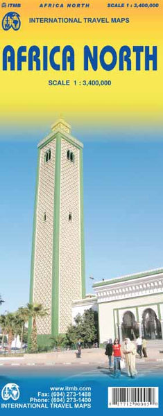
Africa North ITMB Map
$24.95
Afterpay is only available for orders between $50.00 and $1000.00 More info
Scale: 1:3,400,000 | Double-Sided | Size: 1000mm x 690mm
Publisher: ITMB (International Travel Maps)
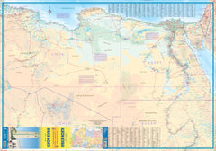
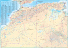
Explore the full sweep of North Africa with this newly enhanced regional map from ITMB, offering a rare and unified cartographic overview of the entire Mediterranean coastline of the African continent—from Morocco and Algeria to Tunisia, Libya, and Egypt.
This is one of ITMB’s first maps to adopt a newly improved scale and cartographic detail for regional African maps, providing greater clarity and precision for travellers, researchers, and educators. Whether you're studying ancient trade routes, planning overland journeys, or following the geography of modern headlines, this map offers a comprehensive visual reference of one of the world’s most geopolitically complex regions.
🗺️ Key Map Features:
-
Covers the full Mediterranean-facing regions of North Africa, including:
-
Morocco, Algeria, Tunisia, Libya, and Egypt
-
Mediterranean islands such as Djerba and coastal regions of the Sinai Peninsula
-
-
Double-sided format to accommodate detailed rendering of a vast region
-
Accurate road networks and national highways with distances marked
-
Topographic relief shading to show mountain ranges, deserts, and escarpments
-
Borders, major cities, and regional towns clearly labeled
-
Inset detail maps may include key urban centres or regions (subject to edition)
🔍 What Makes This Map Unique?
Unlike most other regional maps, this title attempts something no other publisher has done—presenting the entire North African Mediterranean coast as a contiguous, unified region. It's a fresh approach that invites broader geopolitical and historical understanding, whether for academic, travel planning, or contextual analysis purposes.
While political realities such as border closures (e.g. Morocco-Algeria) or unstable travel zones (e.g. Libya) make on-the-ground navigation challenging, this map serves as an important educational and logistical planning tool, especially for:
-
Aid agencies and NGOs
-
Journalists and researchers
-
Overlanders and expedition planners
-
Historical or cultural study
🧴 Lamination Option (Optional Upgrade)
We offer the option to encapsulate your map in durable 80-micron gloss laminate. Benefits include:
-
Wipe-clean surface – use whiteboard markers or removable map dots
-
UV protection – guards against fading
-
Tear and stain resistance – ideal for repeated handling or field use
Note: Laminated versions are flattened and then sealed. Slight original fold lines from the base map may remain visible.
📦 Format Options:
| Format | Description |
|---|---|
| Paper (Folded) | Standard lightweight map, folds to a compact size – perfect for on-the-go |
| Laminated (Flat) | Encapsulated with 2x 80-micron gloss laminate – durable, waterproof |
📌 Product Specifications:
| Feature | Details |
|---|---|
| Publisher | ITMB – International Travel Maps |
| Scale | 1:3,400,000 |
| Coverage | North Africa – Morocco to Egypt |
| Printed | Double-sided |
| Size (flat) | Approx. 1000mm x 690mm |
| Format | Paper (folded) or Laminated (flat) |
| Edition | Latest available |
🎯 Ideal For:
-
Overland travellers and route planners
-
International aid workers and logistics teams
-
Geopolitical researchers and educators
-
Students of African geography and history
-
Collectors of rare or ambitious regional maps
🛒 Add this groundbreaking North Africa map to your collection today—a powerful, panoramic look at the region beyond borders and headlines.


