- Australia ▾
- Topographic
▾
- Australia AUSTopo 250k (2025)
- Australia 50k Geoscience maps
- Australia 100k Geoscience maps
- Australia 250k Geoscience maps
- Australia 1:1m Geoscience maps
- New Zealand 50k maps
- New Zealand 250k maps
- New South Wales 25k maps
- New South Wales 50k maps
- New South Wales 100k maps
- Queensland 10k maps
- Queensland 25k maps
- Queensland 50k maps
- Queensland 100k maps
- Western Australia 25k maps
- Western Australia 50k maps
- Western Australia 100k maps
- Compasses
- Software
- GPS Systems
- International ▾
- Wall Maps
▾
- World
- Australia & New Zealand
- Countries, Continents & Regions
- Historical
- Vintage National Geographic
- Australian Capital Territory
- New South Wales
- Northern Territory
- Queensland
- South Australia
- Tasmania
- Victoria
- Western Australia
- Celestial
- Children's
- Mining & Resources
- Wine Maps
- Healthcare
- Postcode Maps
- Electoral Maps
- Nautical ▾
- Flags
▾
- Australian Flag Sets & Banners
- Flag Bunting
- Handwavers
- Australian National Flags
- Aboriginal Flags
- Torres Strait Islander Flags
- International Flags
- Flagpoles & Accessories
- Australian Capital Territory Flags
- New South Wales Flags
- Northern Territory Flags
- Queensland Flags
- South Australia Flags
- Tasmania Flags
- Victoria Flags
- Western Australia Flags
- Gifts ▾
- Globes ▾
Dear valued customer. Please note that our checkout is not supported by old browsers. Please use a recent browser to access all checkout capabilities


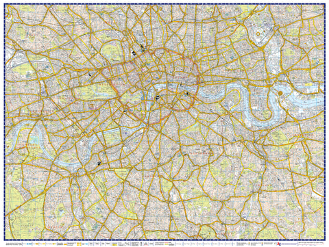
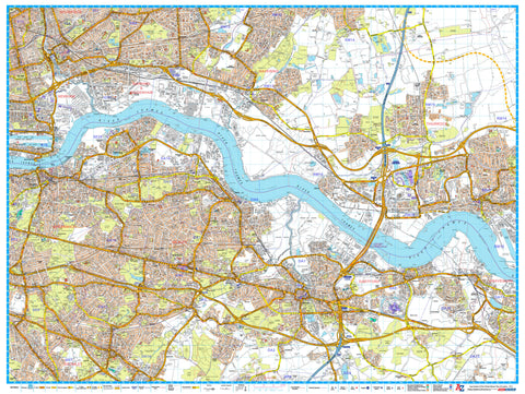
London Master Plan South A-Z 1015 x 763mm Wall Map
$69.95
or make 4 interest-free payments of
$17.49 AUD
fortnightly with
![]() More info
More info
Size: 1015 mm (W) x 763 mm (H)
Scale: 1:21,477
Published: 2019
Publisher: Geographers’ A-Z Map Company
🧭 Navigate South London with Iconic A-Z Accuracy
Unfold the full detail of South London with this London Master Plan South Wall Map by the renowned A-Z Mapping Company. Designed for professionals and enthusiasts alike, this detailed street-level map covers the southern boroughs of Greater London with exceptional clarity — making it the perfect reference for planning, education, logistics, or display.
Part of a 9-sheet Master Plan series, this map can be seamlessly joined with adjacent A-Z wall maps to form a continuous view of the entire London area. Whether used alone or as part of a larger layout, it features postcode district boundaries and local authority lines, providing essential data in a highly readable format.
🔍 Key Features
| ✅ | Feature |
|---|---|
| 🗺️ | Highly detailed street-level mapping |
| 🏘️ | Includes borough and district boundaries |
| 📮 | Clearly defined postcode districts |
| 🚇 | Shows railways, Underground stations |
| 🏞️ | Includes parks, rivers, civic features |
| 🧩 | Can be joined with adjacent Master Plans |
📍 Coverage Highlights
Covers the dynamic and diverse southern regions of the capital, including:
-
Clapham
-
Brixton
-
Streatham
-
Tooting
-
Wimbledon
-
Mitcham
-
Croydon
-
Crystal Palace
-
Dulwich
-
Peckham
Perfect for those working across multiple boroughs or studying South London's infrastructure, demographics, or geography.
📐 Specifications
| Attribute | Detail |
|---|---|
| Scale | 1:21,477 |
| Size | 1015 mm (wide) x 763 mm (high) |
| Publisher | Geographers’ A-Z Map Company |
| Edition | 2019 |
| Map Series | 1 of 9 in the A-Z Master Plan set |
| Base Mapping | Ordnance Survey / A-Z Street Data |
🖨️ Format Options
| 📄 Format | 📋 Description |
|---|---|
| Paper (160 gsm) | High-quality satin paper, ideal for framing or pinning |
| Laminated | Fully encapsulated in gloss laminate — waterproof, tear-resistant, and wipeable |
| Laminated with Hang Rails | Supplied ready-to-hang with elegant timber rails and cord |
| Canvas (395 gsm) | Museum-grade matte canvas with pigment-based archival inks for vibrant durability |
| Canvas with Hang Rails | Canvas mounted with wooden hang rails — a timeless and professional finish |
🎯 Who’s It For?
-
🏙️ Urban planners and architects needing a clear overview of boroughs
-
🚚 Delivery and logistics firms using postcode demarcations
-
🏫 Educators and students studying London’s geography and infrastructure
-
🏢 Corporate offices or council buildings needing informative wall décor
-
🖼️ Interior stylists creating sophisticated, location-themed spaces
Build your complete map wall of Greater London or showcase South London on its own with this authoritative, highly legible, and visually impressive cartographic piece.
Plan, explore, and display with confidence — London starts here.
Frequently Asked Questions
What are the dimensions of the London Master Plan South A-Z 1015 x 763mm Wall Map?
Mapworld wall maps range from standard 700×1000mm to large-format 1000×1430mm Supermaps. The exact dimensions for this map are shown in the product title. Where multiple sizes are available, select your preferred size when adding to cart.
Is this wall map available laminated?
Many Mapworld wall maps are available in paper, laminated, or framed finishes. Check the product options when adding to cart. Laminated maps are wipe-clean and more durable.
Is this the latest edition?
Mapworld stocks the most current editions available from all publishers. Edition year is shown in the product title where applicable. Mapworld updates its catalogue as new editions are released.
Can I write on or pin this wall map?
Laminated wall maps can be written on with whiteboard markers and wiped clean. Paper maps can be pinned on a corkboard. Choose a laminated option for a writeable surface.
Does Mapworld ship the London Master Plan South A-Z 1015 x 763mm Wall Map across Australia?
Yes, Mapworld ships Australia-wide. Standard shipping is a flat $7 rate, with free standard shipping on orders over $75. Express options are available at checkout. Most orders placed before 2pm AEST on weekdays are dispatched same day.
Related Items
© 2026 Mapworld. Website designed by Genie Media
X