- Australia ▾
- Topographic
▾
- Australia AUSTopo 250k (2025)
- Australia 50k Geoscience maps
- Australia 100k Geoscience maps
- Australia 250k Geoscience maps
- Australia 1:1m Geoscience maps
- New Zealand 50k maps
- New Zealand 250k maps
- New South Wales 25k maps
- New South Wales 50k maps
- New South Wales 100k maps
- Queensland 10k maps
- Queensland 25k maps
- Queensland 50k maps
- Queensland 100k maps
- Compasses
- Software
- GPS Systems
- Orienteering
- International ▾
- Wall Maps
▾
- World
- Australia & New Zealand
- Countries, Continents & Regions
- Historical
- Vintage National Geographic
- Australian Capital Territory
- New South Wales
- Northern Territory
- Queensland
- South Australia
- Tasmania
- Victoria
- Western Australia
- Celestial
- Children's
- Mining & Resources
- Wine Maps
- Healthcare
- Postcode Maps
- Electoral Maps
- Nautical ▾
- Flags
▾
- Australian Flag Sets & Banners
- Flag Bunting
- Handwavers
- Australian National Flags
- Aboriginal Flags
- Torres Strait Islander Flags
- International Flags
- Flagpoles & Accessories
- Australian Capital Territory Flags
- New South Wales Flags
- Northern Territory Flags
- Queensland Flags
- South Australia Flags
- Tasmania Flags
- Victoria Flags
- Western Australia Flags
- Gifts ▾
- Globes ▾
Dear valued customer. Please note that our checkout is not supported by old browsers. Please use a recent browser to access all checkout capabilities


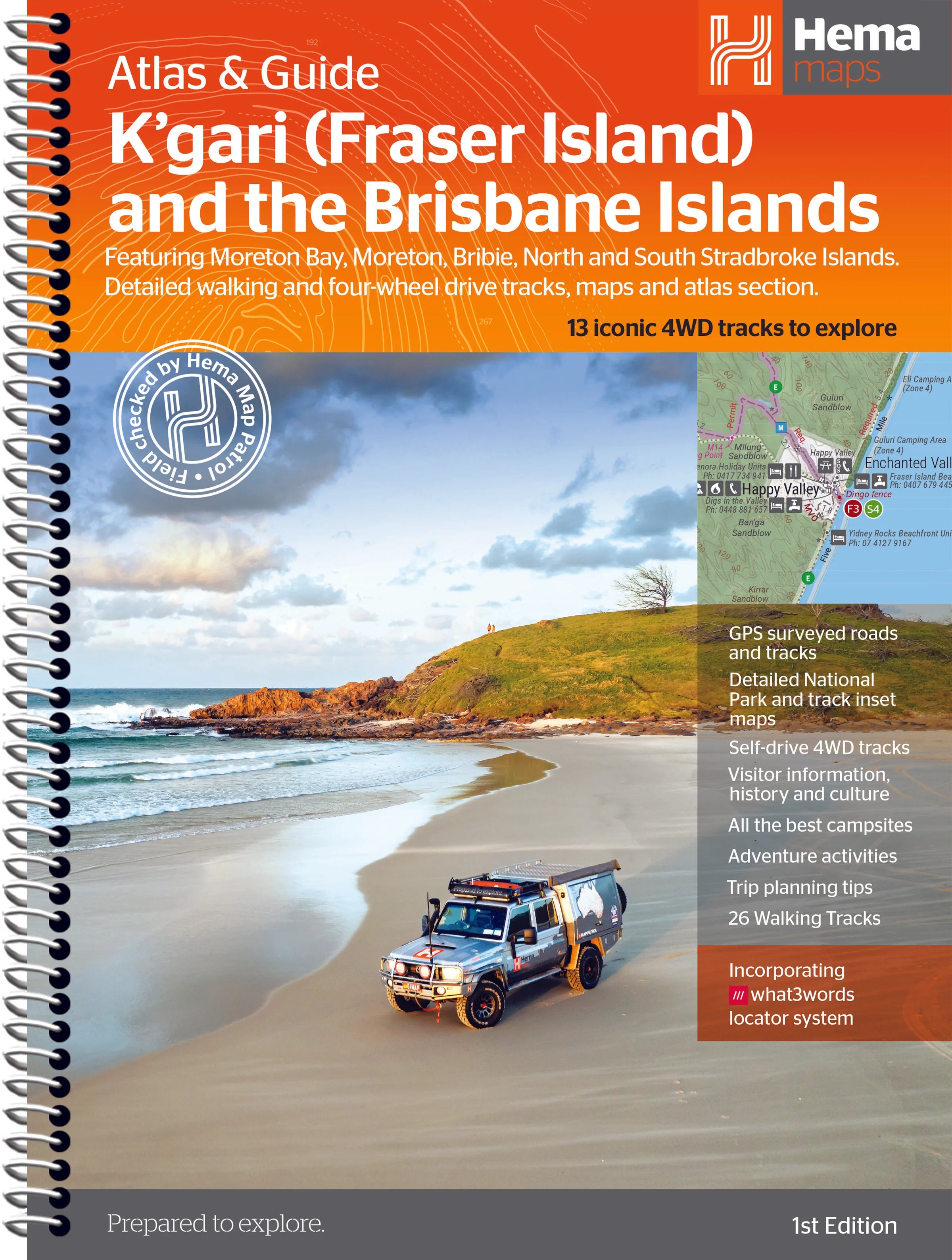
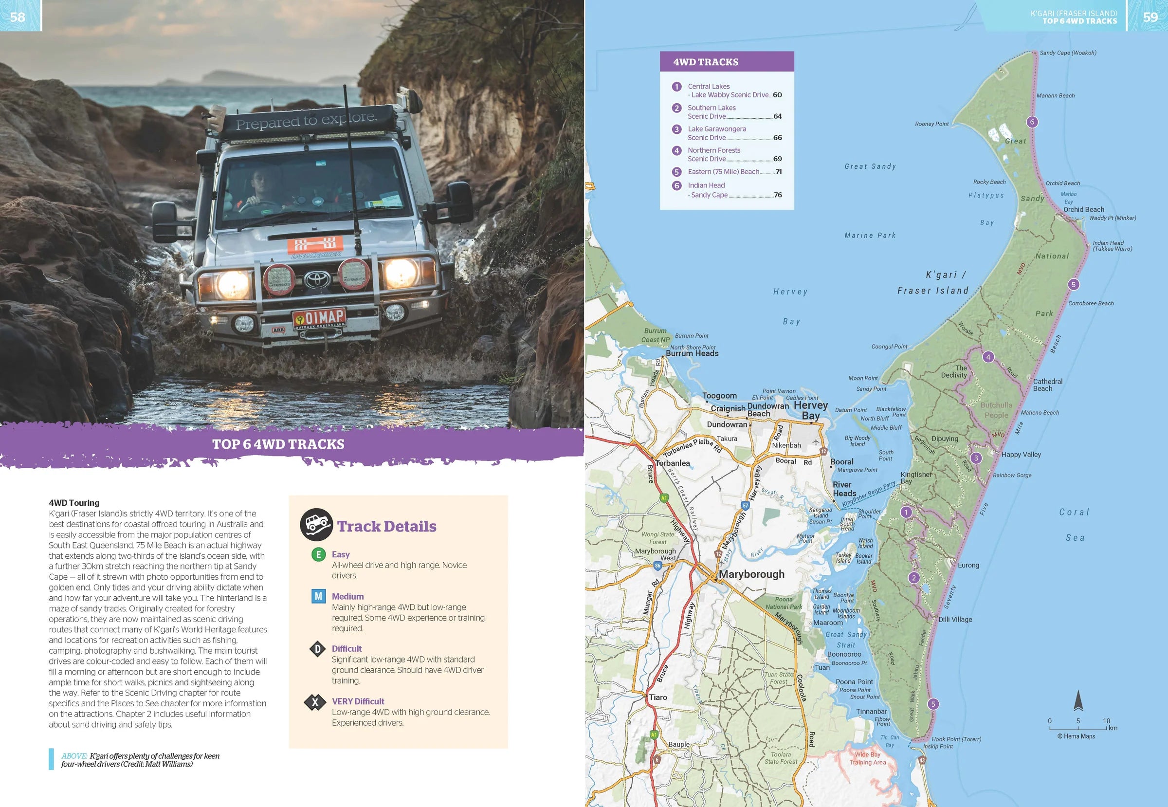
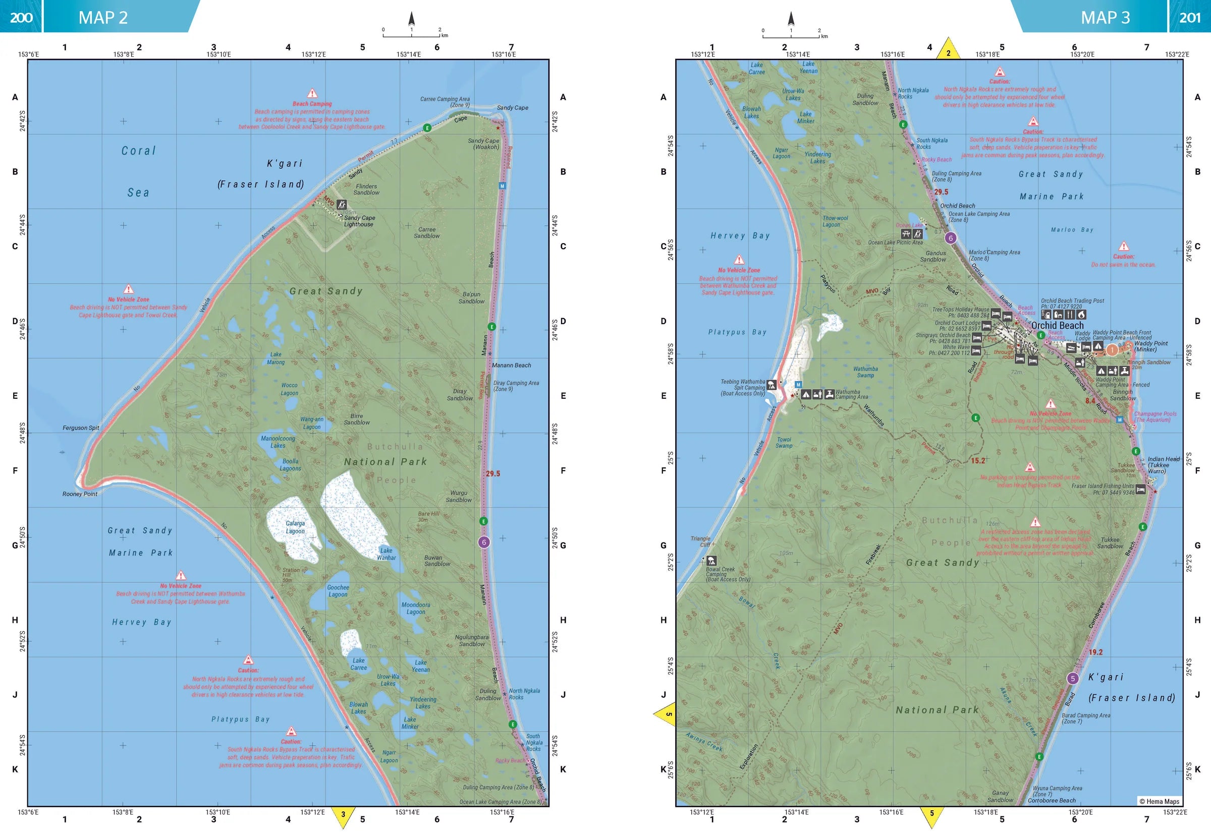
Fraser Island Atlas & Guide Hema
$49.95
Afterpay is only available for orders between $50.00 and $1000.00 More info
Your Essential Companion to Queensland’s Iconic Sand Islands
Explore the natural wonders, cultural heritage, and off-road adventures of Australia’s most celebrated sand islands with the K’gari (Fraser Island) & Brisbane Islands Atlas & Guide by Hema Maps. Whether you're a seasoned four-wheel driver, a curious bushwalker, or a coastal explorer, this beautifully crafted atlas is your ticket to discovering the full breadth of Queensland’s island jewels.
Authored by travel writer Chris Whitelaw and backed by Hema’s field-verified cartography, this guide combines expert local knowledge with unrivalled detail—perfect for both trip planning and on-the-ground navigation.
🏝️ Destinations Covered
This comprehensive guide explores:
-
K’gari (Fraser Island) – The world’s largest sand island, known for its crystal-clear lakes, rainforest trails, and dingo-populated beaches
-
Moreton Island – Home to the famous Tangalooma Wrecks and dramatic sand dunes
-
North Stradbroke Island (Minjerribah) – A cultural and scenic gem with pristine surf beaches and walking tracks
-
South Stradbroke Island – A peaceful retreat with rugged charm
-
Bribie Island – The closest island escape to Brisbane, with great 4WD beach access and calm waters
🗺️ Atlas & Mapping Highlights
-
Hema Maps’ trusted cartography — with clearly marked roads, 4WD tracks, topographic features, campsites, and facilities
-
Detailed 4WD track mapping and bushwalking trail coverage across all five islands
-
13 epic 4WD adventures mapped and described in detail, with grading, trip notes, and longest fuel-free distances
-
26 bushwalking tracks, each with trail notes and natural highlights
-
Comprehensive road atlas section of each island for easy reference and trip planning
📚 What You’ll Learn and Discover
| Feature | Details |
|---|---|
| 🌿 Nature & Ecosystems | Learn about island biodiversity, unique geology, dune systems, and coastal habitats |
| 📖 Cultural Heritage | Insight into Indigenous stories and historical landmarks across the islands |
| 🛠️ Practical Planning Tools | Campsite info, permits, facilities, access points, picnic areas, and safety advice |
| 📍 Must-See Attractions | Lakes, lookouts, shipwrecks, walking tracks, and secret spots you won’t want to miss |
🚗 Who This Guide is For
-
4WD enthusiasts seeking off-grid tracks and iconic routes like Sandy Cape, Lake McKenzie, and more
-
Bushwalkers and hikers exploring rainforest trails and coastal cliffs
-
Family travellers planning camping trips with reliable facility and access info
-
Eco-tourists and heritage seekers looking for meaningful connection with land and culture
-
Photographers and nature lovers chasing the golden hour across dunes and inland lakes
📘 Key Specifications
| Specification | Detail |
|---|---|
| Format | Softcover atlas & guide |
| Pages | Full-colour throughout, packed with maps, images, and informative text |
| Mapping | Hema Maps’ award-winning field-checked cartography |
| Size | Large-format for easy readability in-vehicle or at the campsite |
| Edition | Latest available edition by Hema Maps |
🌊 Why Choose This Guide
✅ All-in-one – navigation, history, culture, and track notes
✅ Field-verified – Hema’s Map Patrol has driven and walked the routes
✅ Beautifully illustrated – full-colour maps, images, and layout
✅ Essential for planning, exploring, and preserving the magic of these islands
Whether you're standing atop the dunes of Moreton, floating in the waters of Eli Creek, or following ancient pathways through the forests of K’gari, this guide will be your trusted companion—before, during, and after your journey.
Unfold the magic of Queensland’s coastal wilderness. Let the adventure begin.
Frequently Asked Questions
What does the Fraser Island Atlas & Guide Hema cover?
This atlas covers the geographic region indicated in the product title, including roads, towns, distances, and key travel information. Mapworld stocks atlases for Australian states and territories, 4WD regions, and international destinations.
Is this the latest edition?
Yes, this is the latest edition. Mapworld stocks the most current editions available from publishers.
Is this atlas or guide spiral bound?
Spiral binding is indicated in the product title where applicable. Spiral-bound atlases and guides lay flat when open, making them ideal for use in vehicles or on a table without needing to hold pages open.
Is the Fraser Island Atlas & Guide Hema in stock at Mapworld?
Mapworld maintains extensive stock across its map range and aims for fast dispatch. Orders placed before 2pm AEST on business days are typically dispatched the same day, with standard and express Australia-wide delivery options available.
Does Mapworld ship the Fraser Island Atlas & Guide Hema across Australia?
Yes, Mapworld ships Australia-wide. Standard shipping is a flat $7 rate, with free standard shipping on orders over $75. Express options are available at checkout. Most orders placed before 2pm AEST on weekdays are dispatched same day.
Related Items
© 2026 Mapworld. Website designed by Genie Media
X