- Australia ▾
- Topographic
▾
- Australia AUSTopo 250k (2024)
- Australia 50k Geoscience maps
- Australia 100k Geoscience maps
- Australia 250k Geoscience maps
- Australia 1.1m Geoscience maps
- New Zealand 50k maps
- New Zealand 250k maps
- New South Wales 25k maps
- New South Wales 50k maps
- New South Wales 100k maps
- Queensland 10k maps
- Queensland 25k maps
- Queensland 50k maps
- Queensland 100k maps
- Compasses
- Software
- GPS Systems
- Orienteering
- International ▾
- Wall Maps
▾
- World
- Australia & New Zealand
- Countries, Continents & Regions
- Historical
- Vintage National Geographic
- Australian Capital Territory
- New South Wales
- Northern Territory
- Queensland
- South Australia
- Tasmania
- Victoria
- Western Australia
- Celestial
- Children's
- Mining & Resources
- Wine Maps
- Healthcare
- Postcode Maps
- Electoral Maps
- Nautical ▾
- Flags
▾
- Australian Flag Sets & Banners
- Flag Bunting
- Handwavers
- Australian National Flags
- Aboriginal Flags
- Torres Strait Islander Flags
- International Flags
- Flagpoles & Accessories
- Australian Capital Territory Flags
- New South Wales Flags
- Northern Territory Flags
- Queensland Flags
- South Australia Flags
- Tasmania Flags
- Victoria Flags
- Western Australia Flags
- Gifts ▾
- Globes ▾
Dear valued customer. Please note that our checkout is not supported by old browsers. Please use a recent browser to access all checkout capabilities


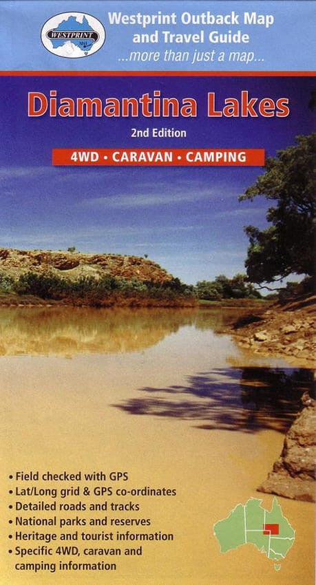
Diamantina Lakes Map Westprint
$13.95 $14.95
Afterpay is only available for orders between $50.00 and $1000.00 More info
Birdsville | Boulia | Winton | Longreach | Windorah | Outback Queensland | GPS-Checked | 4WD & Touring Map
Explore the legendary heart of Outback Queensland with the Diamantina Lakes Map by Westprint – a detailed, GPS-verified regional touring map that covers one of the most remote and fascinating areas of Australia. This easy-to-read yet richly informative map spans the region from Birdsville and Boulia, through Winton, Longreach, and Windorah, offering an unmatched resource for road trippers, 4WD enthusiasts, history buffs, and nature lovers.
Perfect for planning your journey across vast plains, ancient river systems, and rugged escarpments, this map is more than a navigation tool — it’s a gateway to the stories and natural beauty of Queensland’s far west.
🌟 Key Features:
-
🧭 Lat/Long Grid & GPS Coordinates
Accurate positioning for route planning and navigation, compatible with GPS and mapping devices. -
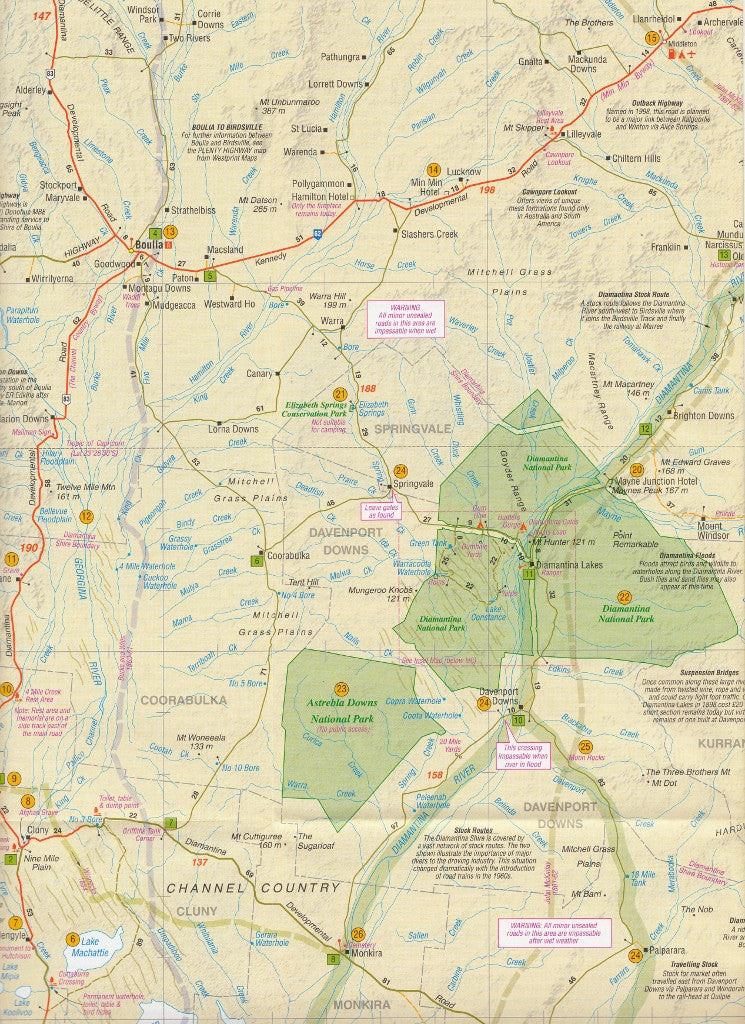
🛣️ Detailed Roads & Tracks
Includes sealed and unsealed roads, 4WD tracks, station access routes, and distances. -
🌳 National Parks & Reserves
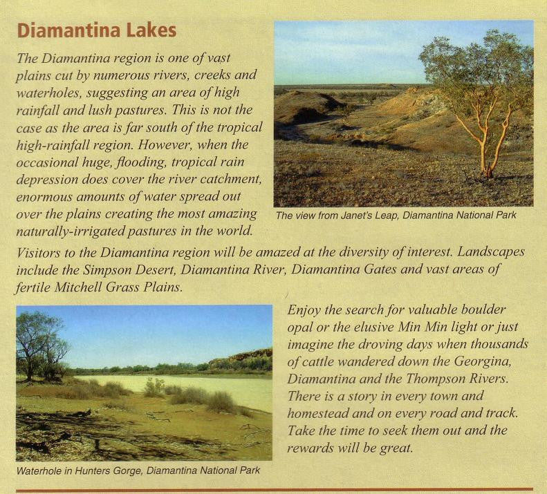
Highlights protected areas such as Diamantina National Park, with access points and key features marked. -
🐾 Flora, Fauna & Natural History
Points of ecological and environmental interest are cross-referenced with notes on the reverse side. -
📚 Heritage & Tourist Information
Learn about pastoral pioneers, Aboriginal history, and iconic outback stories woven into the landscape. -
🚐 4WD, Caravan & Camping Information
Includes locations of rest areas, bush camps, fuel stops, and essential services for overlanders and off-grid travellers.
🏞️ Area Coverage:
This map focuses on a large swathe of remote Queensland outback, including:
-
Birdsville – gateway to the Simpson Desert and home of the famous Birdsville Races
-
Boulia – known for Min Min lights and Channel Country heritage
-
Winton – the birthplace of "Waltzing Matilda" and dinosaur discovery hotspot
-
Longreach – with the iconic Stockman’s Hall of Fame and Qantas Founders Museum
-
Windorah – at the meeting of the Barcoo and Thomson rivers, forming the mighty Cooper Creek
🖼️ Bonus Content:
-
✔️ Reverse-Side Index – A comprehensive reference of marked features, flora and fauna, and historical points.
-
✔️ Historical Notes – Fascinating insights into the exploration, settlement, and natural history of the region.
-
✔️ Photography – Includes stunning full-colour images that bring the landscape to life.
📐 Map Specifications:
| Feature | Details |
|---|---|
| Publisher | Westprint Heritage Maps |
| Scale | 1:1,000,000 |
| Format | Folded Map (Double-Sided) |
| GPS-Checked | Yes |
| Printed Features | Topography, towns, rivers, roads, tracks, POIs |
| Map Size | Standard touring map size |
🛻 Ideal For:
-
4WD tourers and off-grid adventurers
-
Caravaners and long-distance travellers
-
Nature and wildlife enthusiasts
-
Students and educators in geography or history
-
Anyone with a passion for outback Australia
Follow the winding channels, traverse sunburnt plains, and discover the stories that live in the dust of the Diamantina. Whether you're navigating remote roads or dreaming of your next escape, this map is an essential companion for your outback journey.
📦 Order yours today and explore the Queensland outback with confidence and curiosity.