- Australia ▾
- Topographic
▾
- Australia AUSTopo 250k (2025)
- Australia 50k Geoscience maps
- Australia 100k Geoscience maps
- Australia 250k Geoscience maps
- Australia 1:1m Geoscience maps
- New Zealand 50k maps
- New Zealand 250k maps
- New South Wales 25k maps
- New South Wales 50k maps
- New South Wales 100k maps
- Queensland 10k maps
- Queensland 25k maps
- Queensland 50k maps
- Queensland 100k maps
- Western Australia 25k maps
- Western Australia 50k maps
- Western Australia 100k maps
- Compasses
- Software
- GPS Systems
- International ▾
- Wall Maps
▾
- World
- Australia & New Zealand
- Countries, Continents & Regions
- Historical
- Vintage National Geographic
- Australian Capital Territory
- New South Wales
- Northern Territory
- Queensland
- South Australia
- Tasmania
- Victoria
- Western Australia
- Celestial
- Children's
- Mining & Resources
- Wine Maps
- Healthcare
- Postcode Maps
- Electoral Maps
- Nautical ▾
- Flags
▾
- Australian Flag Sets & Banners
- Flag Bunting
- Handwavers
- Australian National Flags
- Aboriginal Flags
- Torres Strait Islander Flags
- International Flags
- Flagpoles & Accessories
- Australian Capital Territory Flags
- New South Wales Flags
- Northern Territory Flags
- Queensland Flags
- South Australia Flags
- Tasmania Flags
- Victoria Flags
- Western Australia Flags
- Gifts ▾
- Globes ▾
Dear valued customer. Please note that our checkout is not supported by old browsers. Please use a recent browser to access all checkout capabilities


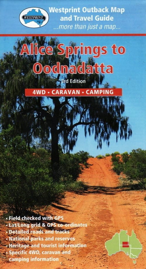
Alice Springs to Oodanatta Map Westprint
$14.95 $15.95
Afterpay is only available for orders between $50.00 and $1000.00 More info
Explore the Heart of Australia’s Red Centre with Confidence
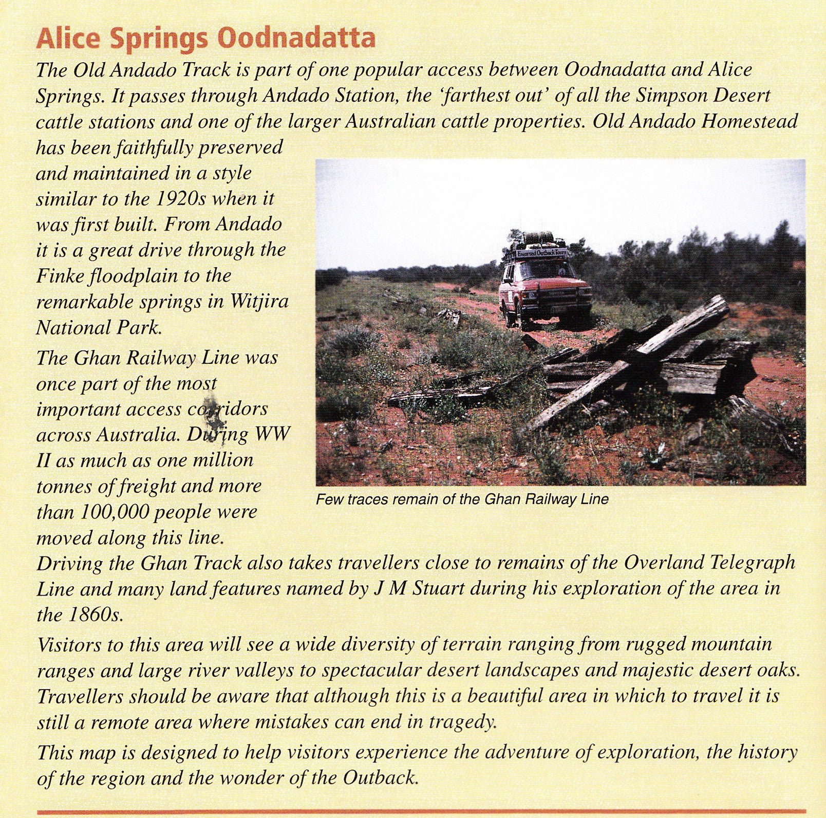
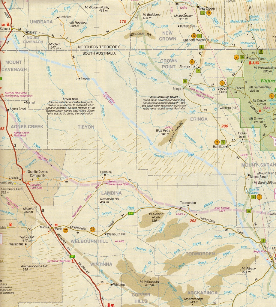
Embark on a true outback journey with the Westprint Alice Springs to Oodnadatta Map, your essential guide for navigating one of Australia’s most iconic and remote travel routes. Covering the vast and rugged terrain between Alice Springs and Oodnadatta, this detailed map is ideal for 4WD adventurers, caravaners, and anyone exploring the Red Centre’s dramatic desert landscapes and historical sites.
Designed for real-world use, this map offers a clear scale of 1:1,000,000, providing an ideal balance between detail and big-picture navigation.
🧭 Key Features:
-
✅ Covers the full route from Alice Springs to Oodnadatta
-
🛣️ Detailed road and track information – sealed, unsealed, 4WD-only and minor tracks
-
🏕️ Specific Caravan & Camping info – rest areas, fuel stops, campsites, and more
-
🏞️ National Parks & Reserves – including travel tips for remote park access
-
📍 Comprehensive GPS Waypoints (Lat/Long) for accurate off-grid navigation
-
🏛️ Heritage & Tourist Sites Marked – ruins, old sidings, Aboriginal landmarks
-
🗺️ Inset maps and notes for added regional context and clarity
🚙 Ideal For:
-
4WD travellers exploring the Oodnadatta Track or the Old Ghan Railway Route
-
Caravaners and campers needing reliable terrain and facilities info
-
History buffs keen to visit remote heritage towns and sites
-
Red Centre explorers heading to Chambers Pillar, Finke, Mount Dare, Dalhousie Springs, or the Simpson Desert
📘 Product Specifications
| Feature | Details |
|---|---|
| Title | Alice Springs to Oodnadatta |
| Publisher | Westprint |
| Scale | 1:1,000,000 |
| Format | Folded Map |
| GPS Waypoints | Included (Lat/Long format) |
| Coverage | Alice Springs, Finke, Mount Dare, Oodnadatta, and surrounds |
🛒 Take the guesswork out of your next desert expedition and travel prepared with the trusted detail of Westprint’s Alice Springs to Oodnadatta Map.
Perfect for planning, navigating, and discovering the unforgettable outback landscapes of Central Australia.
Frequently Asked Questions
What does the Alice Springs to Oodanatta Map Westprint cover?
The Alice Springs to Oodanatta Map Westprint covers 4WD tracks, camping areas, and travel routes for the region described in the product title. Most 4WD and camping guides in Mapworld's range include GPS coordinates, distance information, difficulty ratings, and notes on fuel stops and emergency contact points.
Is the Alice Springs to Oodanatta Map Westprint up to date?
Yes, this is the current edition. Mapworld stocks current editions from publishers including Hema Maps, Westprint, and others.
Is this product suitable for remote area travel?
Yes, 4WD maps and guides are designed for remote area navigation and trip planning. They include track conditions, fuel availability, camping spots, and safety information.
Does Mapworld ship the Alice Springs to Oodanatta Map Westprint across Australia?
Yes, Mapworld ships Australia-wide. Standard shipping is a flat $7 rate, with free standard shipping on orders over $75. Express options are available at checkout. Most orders placed before 2pm AEST on weekdays are dispatched same day.
Related Items


© 2026 Mapworld. Website designed by Genie Media
X