- Australia ▾
- Topographic
▾
- Australia AUSTopo 250k (2025)
- Australia 50k Geoscience maps
- Australia 100k Geoscience maps
- Australia 250k Geoscience maps
- Australia 1:1m Geoscience maps
- New Zealand 50k maps
- New Zealand 250k maps
- New South Wales 25k maps
- New South Wales 50k maps
- New South Wales 100k maps
- Queensland 10k maps
- Queensland 25k maps
- Queensland 50k maps
- Queensland 100k maps
- Western Australia 25k maps
- Western Australia 50k maps
- Western Australia 100k maps
- Compasses
- Software
- GPS Systems
- International ▾
- Wall Maps
▾
- World
- Australia & New Zealand
- Countries, Continents & Regions
- Historical
- Vintage National Geographic
- Australian Capital Territory
- New South Wales
- Northern Territory
- Queensland
- South Australia
- Tasmania
- Victoria
- Western Australia
- Celestial
- Children's
- Mining & Resources
- Wine Maps
- Healthcare
- Postcode Maps
- Electoral Maps
- Nautical ▾
- Flags
▾
- Australian Flag Sets & Banners
- Flag Bunting
- Handwavers
- Australian National Flags
- Aboriginal Flags
- Torres Strait Islander Flags
- International Flags
- Flagpoles & Accessories
- Australian Capital Territory Flags
- New South Wales Flags
- Northern Territory Flags
- Queensland Flags
- South Australia Flags
- Tasmania Flags
- Victoria Flags
- Western Australia Flags
- Gifts ▾
- Globes ▾
Dear valued customer. Please note that our checkout is not supported by old browsers. Please use a recent browser to access all checkout capabilities


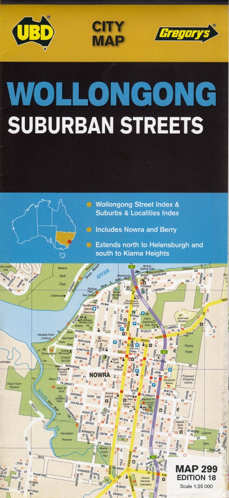
Wollongong Nowra & Berry UBD Map 299
Sold Out
Afterpay is only available for orders between $50.00 and $1000.00 More info
Scale: 1:25,000 | Suburban Street Map | Folded or Laminated Option Available
Navigate the South Coast with Precision and Clarity
Whether you're a local business owner, a house hunter, a delivery driver, or simply someone who wants to get to know the Illawarra region better, the UBD Gregory’s Wollongong, Nowra & Berry Suburban Streets Map is an invaluable tool for exploring the area with ease and confidence.
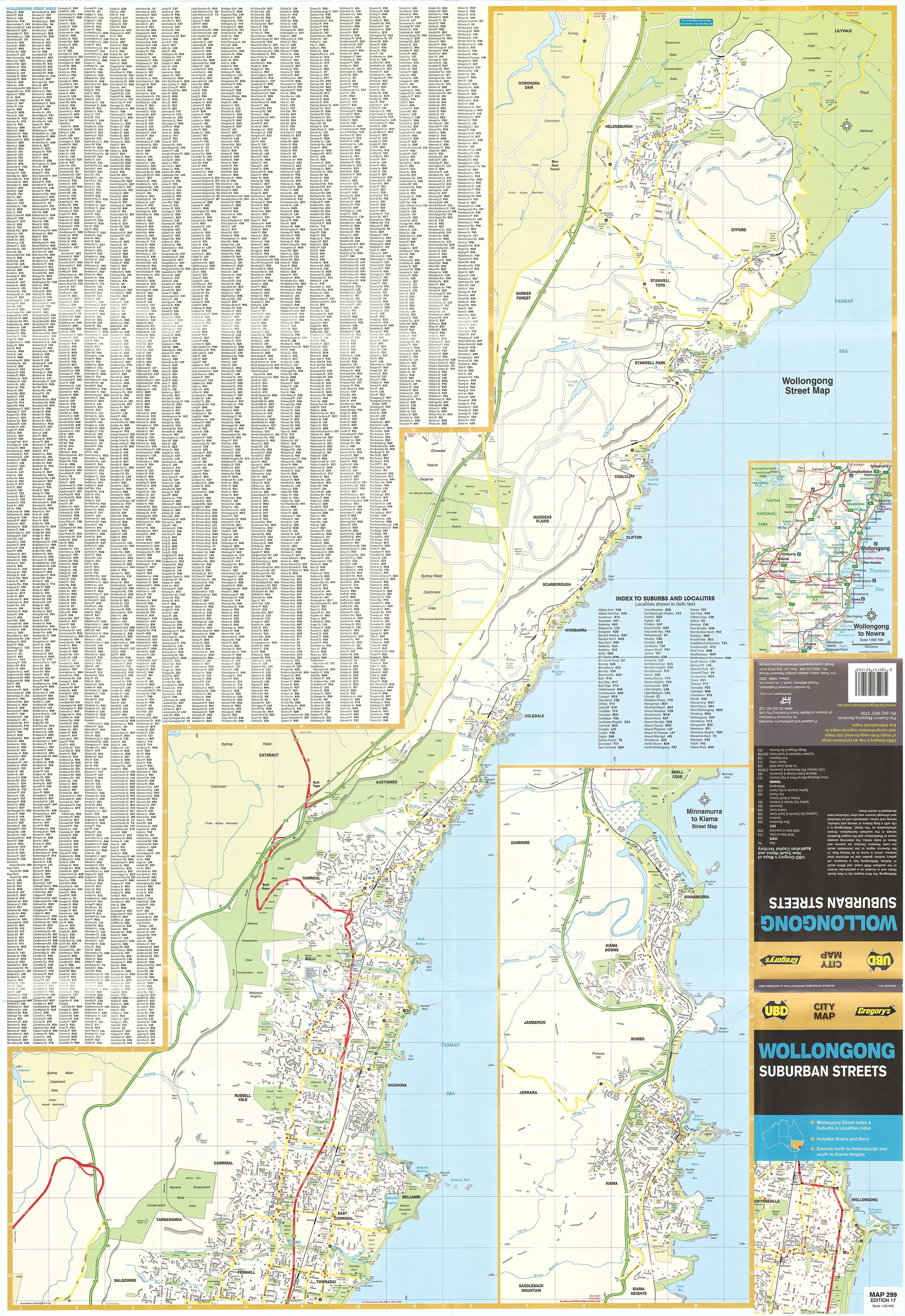
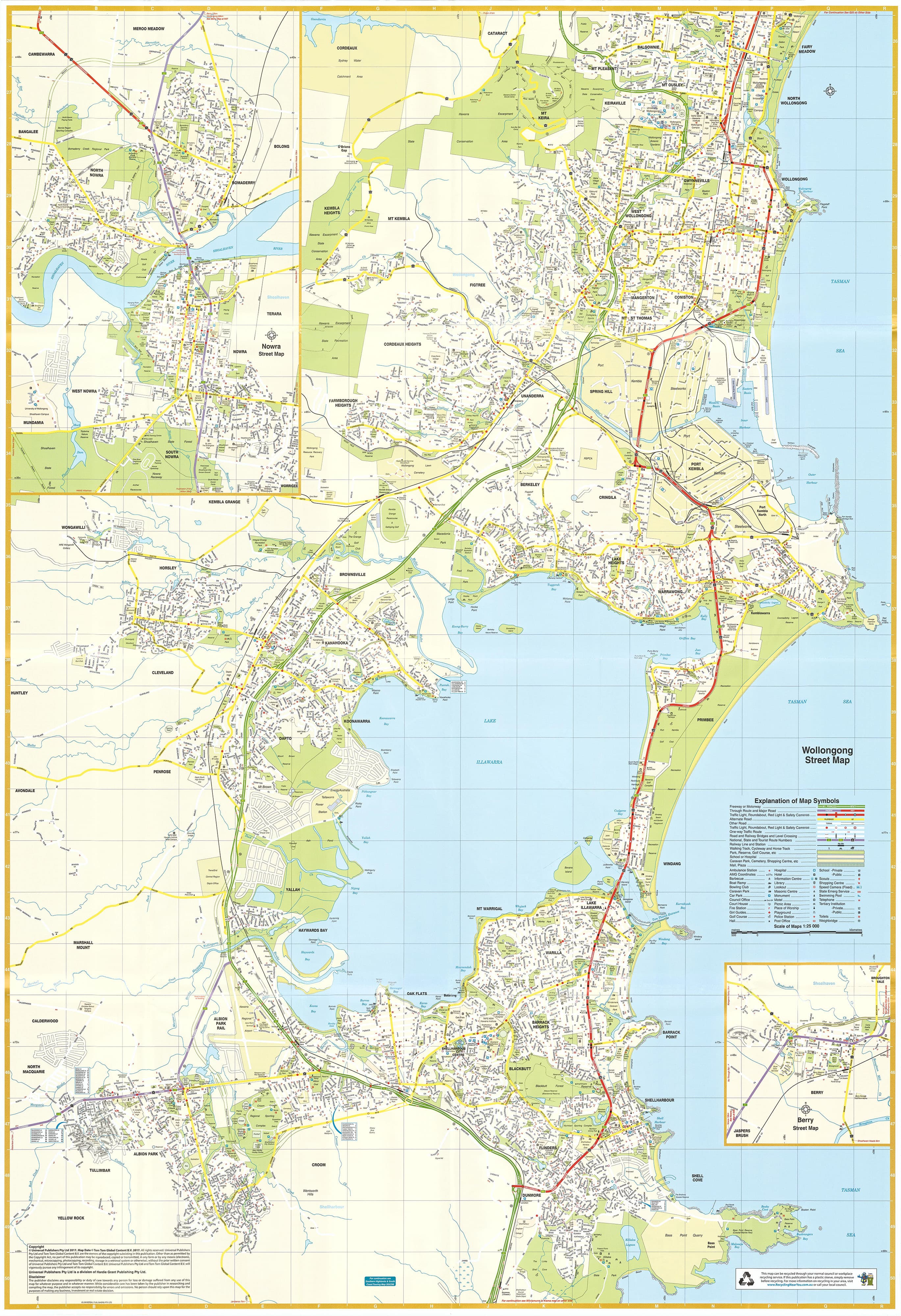
This highly detailed street-level map provides a clear view of Wollongong and surrounding suburbs, stretching north to Helensburgh and south to Kiama, and includes additional detailed town maps of Nowra and Berry — two of the South Coast’s most popular and picturesque communities.
Created by UBD Gregory's, a trusted name in Australian cartography, this map is ideal for anyone needing reliable navigation across the region — from homeowners and tradies to planners, educators, and tourists.
Coverage Area
-
Wollongong Metropolitan Region – from Helensburgh and Stanwell Tops in the north, through Thirroul, Fairy Meadow, and Port Kembla, down to Kiama in the south
-
Berry – heritage-rich town on the edge of the Shoalhaven
-
Nowra – key regional centre with river access, shopping, and community hubs
Map Features
-
🏘️ Full Suburb and Street Index – Quickly locate any address, street, or suburb with the user-friendly reference system
-
🏫 Community Landmarks – Schools, shopping centres, parks, playgrounds, police stations, libraries, and more clearly marked
-
🛣️ Detailed Road Network – All local roads, major arterials, cul-de-sacs, and public transport corridors shown with precision
-
🚸 Local Facilities – Hospitals, sports fields, aged care centres, places of worship, and other key civic features
-
🌿 Greenspace & Parks – Clearly defined recreational areas, bushland, walking trails, and coastline features
-
🧭 Orientation-Friendly Design – Designed for maximum clarity when navigating on foot, by car, or for urban planning purposes
Laminated Version Available
Want a version that stands up to heavy use? We offer this map fully laminated using high-quality 80-micron gloss laminate, creating a durable “write & wipe” surface ideal for:
-
Real estate agents marking listings
-
Local councils or planners charting boundaries
-
Business owners plotting delivery zones
-
Families or schools planning local outings
You can draw on it with a whiteboard marker or apply Map Dots to highlight key locations — and simply wipe clean when done.
🛠️ Please note: For laminated maps, we carefully flatten the folded version and encapsulate it. This means some light fold lines may still be visible, but the result is a strong, reusable and highly functional map for ongoing use.
📏 Product Details
| Feature | Details |
|---|---|
| Title | Wollongong, Nowra & Berry UBD Suburban Streets Map 299 |
| Coverage | Wollongong to Kiama, Helensburgh to Nowra & Berry |
| Map Type | Folded street map or laminated wall map |
| Scale | 1:25,000 |
| Map Size | Approx. 700mm x 1000mm (laminated version) |
| Publisher | UBD Gregory’s |
| Finish Options | Paper (folded), Laminated (flat, encapsulated) |
🧳 Who Is This Map For?
-
🏡 House Hunters & Local Residents – Explore suburbs, compare locations, or plan your next move
-
🛠️ Tradies, Couriers & Mobile Services – Identify service zones, travel times and key addresses
-
📦 Local Businesses & Planners – Ideal for delivery management, advertising zones, or service areas
-
🧭 Geography Enthusiasts & Students – Learn local geography or map out regional connections
🛒 Ready to Explore the Illawarra Region?
The UBD 299 Wollongong, Nowra & Berry Map is more than just a navigation aid — it’s a tool for discovery, planning, and connecting with your community. Order your copy today and bring the Illawarra into focus.
Frequently Asked Questions
Where can I buy the Wollongong Nowra & Berry UBD Map 299?
The Wollongong Nowra & Berry UBD Map 299 is available to buy online from Mapworld, Australia's largest map and geographic product retailer, with fast shipping Australia-wide.
Is the Wollongong Nowra & Berry UBD Map 299 in stock at Mapworld?
Mapworld maintains extensive stock across its map range and aims for fast dispatch. Orders placed before 2pm AEST on business days are typically dispatched the same day, with standard and express Australia-wide delivery options available.
What is Mapworld's returns policy?
Mapworld accepts returns on undamaged items in original condition. Contact Mapworld within 90 days of purchase to arrange a return or exchange.
Does Mapworld ship the Wollongong Nowra & Berry UBD Map 299 across Australia?
Yes, Mapworld ships Australia-wide. Standard shipping is a flat $7 rate, with free standard shipping on orders over $75. Express options are available at checkout. Most orders placed before 2pm AEST on weekdays are dispatched same day.
Related Items


© 2026 Mapworld. Website designed by Genie Media
X