- Australia ▾
- Topographic
▾
- Australia AUSTopo 250k (2025)
- Australia 50k Geoscience maps
- Australia 100k Geoscience maps
- Australia 250k Geoscience maps
- Australia 1:1m Geoscience maps
- New Zealand 50k maps
- New Zealand 250k maps
- New South Wales 25k maps
- New South Wales 50k maps
- New South Wales 100k maps
- Queensland 10k maps
- Queensland 25k maps
- Queensland 50k maps
- Queensland 100k maps
- Western Australia 25k maps
- Western Australia 50k maps
- Western Australia 100k maps
- Compasses
- Software
- GPS Systems
- International ▾
- Wall Maps
▾
- World
- Australia & New Zealand
- Countries, Continents & Regions
- Historical
- Vintage National Geographic
- Australian Capital Territory
- New South Wales
- Northern Territory
- Queensland
- South Australia
- Tasmania
- Victoria
- Western Australia
- Celestial
- Children's
- Mining & Resources
- Wine Maps
- Healthcare
- Postcode Maps
- Electoral Maps
- Nautical ▾
- Flags
▾
- Australian Flag Sets & Banners
- Flag Bunting
- Handwavers
- Australian National Flags
- Aboriginal Flags
- Torres Strait Islander Flags
- International Flags
- Flagpoles & Accessories
- Australian Capital Territory Flags
- New South Wales Flags
- Northern Territory Flags
- Queensland Flags
- South Australia Flags
- Tasmania Flags
- Victoria Flags
- Western Australia Flags
- Gifts ▾
- Globes ▾
Dear valued customer. Please note that our checkout is not supported by old browsers. Please use a recent browser to access all checkout capabilities


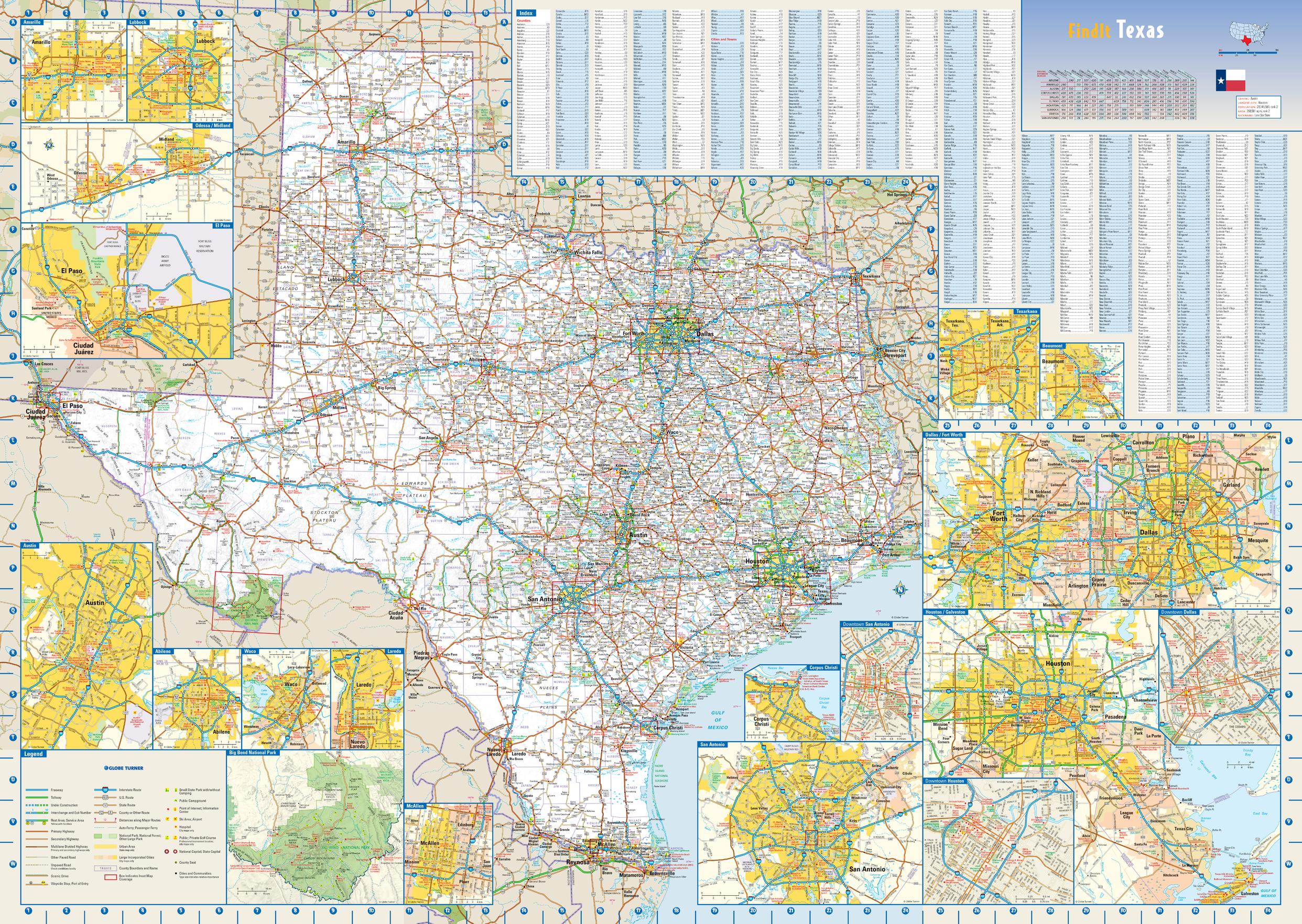
Texas State Wall Map
$69.95
or make 4 interest-free payments of
$17.49 AUD
fortnightly with
![]() More info
More info
Bold. Vast. Unmistakably Texan.
This stunning large-format wall map is your definitive visual companion to the Lone Star State. Whether you’re charting an ambitious road trip, planning business routes, teaching U.S. geography, or simply celebrating your love for Texas, this map combines precision cartography with rich, full-colour topography to create both a functional reference and a decorative centrepiece.
From the rugged Davis Mountains in the west to the wide-open plains of the Panhandle, from the shimmering waters of the Gulf Coast to the rolling Hill Country, this map showcases Texas in vivid clarity. Every highway, byway, city, and landmark is rendered with exceptional accuracy—making it just as valuable for navigation and planning as it is for display.
🌟 Key Features at a Glance
-
Comprehensive State Coverage – Every major thoroughfare, secondary road, and scenic route is clearly marked.
-
Inset City Maps – Zoomed-in detail for Abilene, Amarillo, Austin, Beaumont, Corpus Christi, Dallas / Fort Worth, El Paso, Houston / Galveston, Laredo, Lubbock, McAllen, Odessa / Midland, San Antonio, Texarkana, and Waco.
-
Downtown Insets – Special maps for Downtown Dallas, Downtown Houston, and Downtown San Antonio, perfect for pinpointing landmarks and street grids.
-
Special Interest Insets – Detailed view of Big Bend National Park, a Texas treasure for outdoor explorers.
-
Shaded Terrain Relief – Gives a 3D-like visual of Texas’ diverse geography.
-
Landmarks & Recreation Areas – National and state parks, historic sites, and major attractions clearly identified.
-
County & City Indices – Quickly locate even the smallest towns, with text size reflecting 2020 U.S. Census classifications.
📐 Specifications
| Feature | Detail |
|---|---|
| Map Type | State Wall Map – Texas |
| Dimensions | 1000mm (W) x 700 mm (H) |
| Scale | Statewide overview with detailed insets |
| Publication Year | Current Edition |
| Origin | Made in Australia |
| Finish Options | Paper, Laminated, Laminated with Hang Rails, Canvas, Canvas with Hang Rails |
🖌 Material & Finish Options
| Format | Description |
|---|---|
| Paper (160 gsm) | Heavyweight matte-coated paper – crisp detail, perfect for framing under glass. |
| Laminated | True encapsulation with two layers of 80-micron gloss laminate – waterproof, tear-resistant, and suitable for frequent handling. |
| Laminated with Hang Rails | Adds elegant natural timber rails and a hanging cord – ready for display in seconds. |
| Canvas (395 gsm) | Printed on HP Professional Matte Canvas with pigment-based archival inks – richly textured, fade-resistant, and built to last decades. |
| Canvas with Hang Rails | Combines premium canvas with classic timber rails for a timeless, gallery-style presentation. |
🪵 Wooden Hang Rails
Crafted from lacquered natural timber, our hang rails not only protect the map but also elevate its presentation. The top rail features a strong hanging cord, so installation is as simple as placing a hook on your wall.
Note: Please allow up to 10 working days for delivery of hang-railed maps, as each piece is professionally mounted by our framer.
🎯 Perfect For
-
Road Trip Planners – Visualise routes across Texas’ vast road network.
-
Businesses & Logistics – Plan delivery zones, sales territories, and regional coverage.
-
Educators – A valuable teaching aid for geography, history, and social studies.
-
Texans & Expats – Showcase state pride in a striking, detailed format.
-
Interior Design – Brings colour, character, and conversation to any room.
⭐ Why This Map Stands Out
The Texas State Wall Map is more than a piece of paper with lines and labels—it’s a statement of scale, pride, and purpose. Built for longevity and designed for clarity, it ensures that every name, road, and contour remains sharp and legible for years to come.
Whether it’s mounted in a boardroom, study, classroom, or living space, it will be as much a source of information as it is a symbol of admiration for the great state of Texas.
Frequently Asked Questions
What are the dimensions of the Texas State Wall Map?
Mapworld wall maps range from standard 700×1000mm to large-format 1000×1430mm Supermaps. The exact dimensions for this map are shown in the product title. Where multiple sizes are available, select your preferred size when adding to cart.
Is this wall map available laminated?
Many Mapworld wall maps are available in paper, laminated, or framed finishes. Check the product options when adding to cart. Laminated maps are wipe-clean and more durable.
Is this the latest edition?
Mapworld stocks the most current editions available from all publishers. Edition year is shown in the product title where applicable. Mapworld updates its catalogue as new editions are released.
Can I write on or pin this wall map?
Laminated wall maps can be written on with whiteboard markers and wiped clean. Paper maps can be pinned on a corkboard. Choose a laminated option for a writeable surface.
Does Mapworld ship the Texas State Wall Map across Australia?
Yes, Mapworld ships Australia-wide. Standard shipping is a flat $7 rate, with free standard shipping on orders over $75. Express options are available at checkout. Most orders placed before 2pm AEST on weekdays are dispatched same day.
Related Items


© 2026 Mapworld. Website designed by Genie Media
X