- Australia ▾
- Topographic
▾
- Australia AUSTopo 250k (2025)
- Australia 50k Geoscience maps
- Australia 100k Geoscience maps
- Australia 250k Geoscience maps
- Australia 1:1m Geoscience maps
- New Zealand 50k maps
- New Zealand 250k maps
- New South Wales 25k maps
- New South Wales 50k maps
- New South Wales 100k maps
- Queensland 10k maps
- Queensland 25k maps
- Queensland 50k maps
- Queensland 100k maps
- Western Australia 25k maps
- Western Australia 50k maps
- Western Australia 100k maps
- Compasses
- Software
- GPS Systems
- International ▾
- Wall Maps
▾
- World
- Australia & New Zealand
- Countries, Continents & Regions
- Historical
- Vintage National Geographic
- Australian Capital Territory
- New South Wales
- Northern Territory
- Queensland
- South Australia
- Tasmania
- Victoria
- Western Australia
- Celestial
- Children's
- Mining & Resources
- Wine Maps
- Healthcare
- Postcode Maps
- Electoral Maps
- Nautical ▾
- Flags
▾
- Australian Flag Sets & Banners
- Flag Bunting
- Handwavers
- Australian National Flags
- Aboriginal Flags
- Torres Strait Islander Flags
- International Flags
- Flagpoles & Accessories
- Australian Capital Territory Flags
- New South Wales Flags
- Northern Territory Flags
- Queensland Flags
- South Australia Flags
- Tasmania Flags
- Victoria Flags
- Western Australia Flags
- Gifts ▾
- Globes ▾
Dear valued customer. Please note that our checkout is not supported by old browsers. Please use a recent browser to access all checkout capabilities


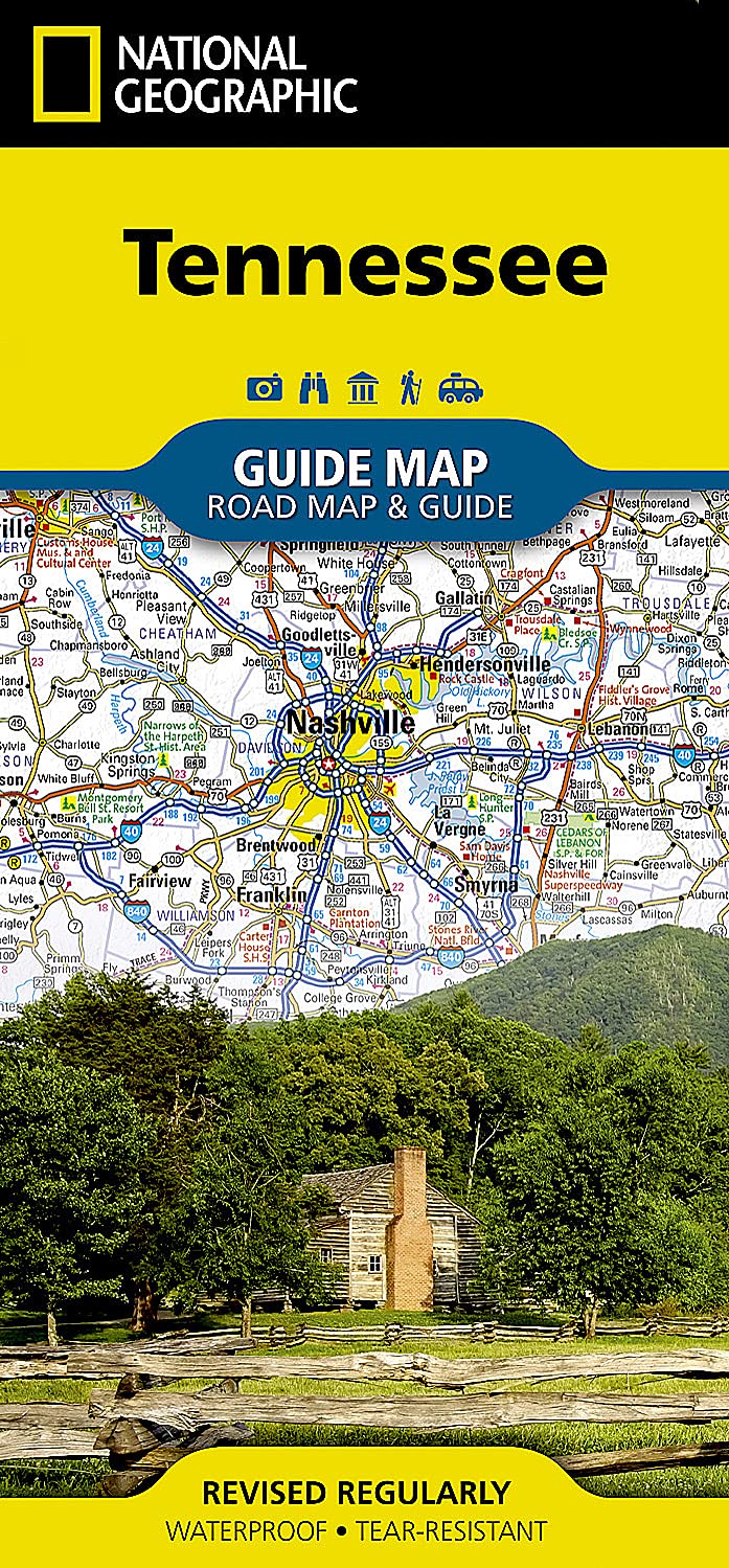


Tennessee National Geographic Folded Map
$29.95
Afterpay is only available for orders between $50.00 and $1000.00 More info
Tennessee – National Geographic State Guide Map
Waterproof • Tear-Resistant • Travel Map
From the lively streets of Nashville to the misty peaks of the Great Smoky Mountains, the National Geographic Tennessee Guide Map is your ultimate companion for exploring the Volunteer State. Blending expert cartography with a practical travel guide, it’s designed for both road trip adventurers and city explorers who want detail, accuracy, and durability in one easy-to-use resource.
📍 Comprehensive Statewide Coverage
-
Complete Tennessee Road Network – Includes interstates, toll roads, U.S. highways, state and county routes, and scenic byways
-
Road Surface Types – Clear designations for paved, unpaved, and toll routes
-
Mileage Indicators – Distances marked on major highways for precise trip planning
-
Scenic Route Markers – Highlighted drives with pinpointed wayside stops
-
Comprehensive Index – Cities, towns, and counties for quick reference
-
Driving Distance Chart – Handy mileage guide between major destinations
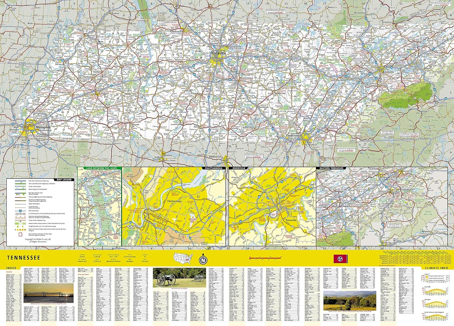
🗺 Detailed Inset Maps
-
Knoxville
-
Chattanooga
-
Nashville
-
Memphis
-
Land Between the Lakes Recreation Area
🌟 Featured Attractions & Scenic Highlights
-
Great Smoky Mountains National Park – Special coverage with detailed maps and visitor information
-
Natchez Trace Parkway Scenic Drive – Explore one of America’s most historic and picturesque routes
-
National & State Parks – Locations, facilities, and key features clearly marked
-
National Forests & Recreation Areas – Perfect for hiking, camping, and outdoor adventures
📖 Travel Guide Content
-
Event Calendar – Seasonal highlights and annual celebrations
-
Points of Interest Overview – Historical sites, cultural attractions, and natural wonders
-
National Park Service Facilities Chart – Amenities and services available at Tennessee’s parks
-
Visitor Resources – Contact details for parks, attractions, and travel services
📐 Product Specifications
| Feature | Detail |
|---|---|
| Publisher | National Geographic Maps |
| Map Type | Folded State Guide Map |
| Material | Waterproof, tear-resistant synthetic paper |
| Format | Double-sided |
| Flat Size | 660 mm x 940 mm (26" x 37") |
| Folded Size | 102 mm x 229 mm (4" x 9") |
| Order Info | Order on Demand – Please allow 7–10 working days for delivery |
🎯 Ideal For
-
Road trippers exploring Tennessee’s music cities and mountain landscapes
-
History enthusiasts tracing Civil War battlefields and heritage trails
-
Outdoor adventurers hiking in the Smokies or camping in state parks
-
Tour planners and educators needing accurate, high-quality reference material
With National Geographic’s Tennessee Guide Map, you’ll enjoy clear navigation, essential travel tips, and durable quality—making it the perfect tool for discovering every mile of Tennessee, from bustling city streets to serene backroads
Frequently Asked Questions
What area does the Tennessee National Geographic Folded Map cover?
The Tennessee National Geographic Folded Map provides road coverage of the region named in the product title. The map covers major cities, highways, towns, and regional roads, with inset city maps for key urban centres where applicable.
Is the Tennessee National Geographic Folded Map up to date?
Yes, this is the current edition. Mapworld stocks the most current editions from all major publishers, updated to reflect new roads and infrastructure.
What size is this map when unfolded?
Folded maps from Mapworld's range are compact and portable. Most standard folded road or travel maps open to between A1 (594 × 841mm) and A0 (841 × 1189mm) when fully unfolded, and fold down to approximately A4 or smaller for easy storage in a glove box, bag, or backpack.
Is the Tennessee National Geographic Folded Map in stock at Mapworld?
Mapworld maintains extensive stock across its map range and aims for fast dispatch. Orders placed before 2pm AEST on business days are typically dispatched the same day, with standard and express Australia-wide delivery options available.
Does Mapworld ship the Tennessee National Geographic Folded Map across Australia?
Yes, Mapworld ships Australia-wide. Standard shipping is a flat $7 rate, with free standard shipping on orders over $75. Express options are available at checkout. Most orders placed before 2pm AEST on weekdays are dispatched same day.
Related Items


© 2026 Mapworld. Website designed by Genie Media
X