- Australia ▾
- Topographic
▾
- Australia AUSTopo 250k (2025)
- Australia 50k Geoscience maps
- Australia 100k Geoscience maps
- Australia 250k Geoscience maps
- Australia 1:1m Geoscience maps
- New Zealand 50k maps
- New Zealand 250k maps
- New South Wales 25k maps
- New South Wales 50k maps
- New South Wales 100k maps
- Queensland 10k maps
- Queensland 25k maps
- Queensland 50k maps
- Queensland 100k maps
- Western Australia 25k maps
- Western Australia 50k maps
- Western Australia 100k maps
- Compasses
- Software
- GPS Systems
- International ▾
- Wall Maps
▾
- World
- Australia & New Zealand
- Countries, Continents & Regions
- Historical
- Vintage National Geographic
- Australian Capital Territory
- New South Wales
- Northern Territory
- Queensland
- South Australia
- Tasmania
- Victoria
- Western Australia
- Celestial
- Children's
- Mining & Resources
- Wine Maps
- Healthcare
- Postcode Maps
- Electoral Maps
- Nautical ▾
- Flags
▾
- Australian Flag Sets & Banners
- Flag Bunting
- Handwavers
- Australian National Flags
- Aboriginal Flags
- Torres Strait Islander Flags
- International Flags
- Flagpoles & Accessories
- Australian Capital Territory Flags
- New South Wales Flags
- Northern Territory Flags
- Queensland Flags
- South Australia Flags
- Tasmania Flags
- Victoria Flags
- Western Australia Flags
- Gifts ▾
- Globes ▾
Dear valued customer. Please note that our checkout is not supported by old browsers. Please use a recent browser to access all checkout capabilities




Oceania Wall Map Showing Economic Exclusion Zones (EEZ)
$79.95
or make 4 interest-free payments of
$19.99 AUD
fortnightly with
 More info
1000 x 700 mm | Maritime Boundaries of the Pacific | Premium Display Finishes
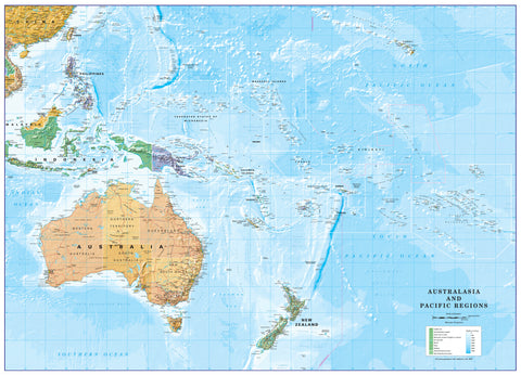
See Oceania the way it is increasingly understood today — not just as a scattering of islands, but as a vast and connected ocean region. This detailed Oceania Wall Map showing Economic Exclusion Zones (EEZs) offers a powerful visual overview of the maritime boundaries that define the modern Pacific.
Beautifully presented and highly informative, this map shows how the countries and territories of Oceania extend far beyond their coastlines through their rights over surrounding seas. It is an exceptional reference for anyone interested in Pacific geography, marine resources, international boundaries, fisheries, ocean governance, and the idea of the Blue Pacific Continent.
Whether displayed in a classroom, university, government office, marine organisation, or home study, this map makes an immediate impression. It is both an educational tool and a striking wall piece that changes the way people see the Pacific.
🌊 A Different Way to See Oceania
Most maps make the Pacific seem empty, with tiny islands separated by enormous stretches of water. This map tells a very different story.
By showing the Economic Exclusion Zones of the countries and territories across Oceania, it reveals the immense maritime reach of the region. These zones define where nations have exclusive rights to manage and benefit from marine resources, making them central to economic development, sovereignty, environmental protection, and regional identity.
This is what makes the map so compelling: it shows that Oceania is not only a region of islands, but one of vast ocean space.
🗺️ Why This Map Matters
Massive Ocean Coverage
The 22 Pacific Island Countries and Territories collectively manage around 20% of the world’s total EEZs. This map helps communicate that extraordinary fact in one clear visual statement.
Sovereign Rights at Sea
EEZs are not just lines on the map. They define where nations have exclusive rights to manage:
-
Living marine resources, such as fish stocks
-
Non-living marine resources, including oil, gas, and seabed minerals
-
Marine areas that are critical to long-term environmental and economic planning
The Blue Pacific Continent
This map vividly illustrates the idea of the Blue Pacific — the understanding that Pacific island nations are not small states isolated by ocean, but large ocean states connected by it.
Overlapping Zones and Maritime Boundaries
Because many islands and archipelagos lie relatively close together, some EEZs overlap. The map helps explain why treaties, negotiations, and international maritime law are so important across the region.
🌏 What the Map Shows
This wall map provides a clear and engaging visual overview of:
-
Economic Exclusion Zones across Oceania
-
Maritime boundaries of Pacific countries and territories
-
The broader regional geography of the Pacific Ocean
-
The relationship between islands, states, and surrounding ocean space
-
A valuable visual framework for understanding sovereignty, marine governance, and resource management
It is especially useful for anyone working or studying in:
-
Geography
-
Pacific studies
-
Marine science
-
Fisheries management
-
International relations
-
Environmental policy
-
Ocean governance
💡 Why You’ll Love This Map
Visually Distinctive
This is an eye-catching and thought-provoking map that immediately stands out on the wall. It is ideal for spaces where you want both beauty and substance.
Educational and Relevant
It is a map that sparks conversation and deepens understanding, making it highly suitable for teaching, presentations, and policy work.
A Unique Regional Perspective
Unlike conventional political maps, this one reveals the true scale of the Pacific and the significance of maritime space in Oceania.
Perfect for Display
At 1000 x 700 mm, it is large enough to make a real impression without overwhelming the wall, making it suitable for offices, classrooms, meeting rooms, and private collections.
✨ Available Finishes
Choose the finish that best suits your display style and how the map will be used:
| Format | Description |
|---|---|
| Paper | Printed on quality paper for a crisp, classic finish. Ideal for framing under glass and perfect for studies, offices, and home display. |
| Laminated | Fully encapsulated for added durability and easy cleaning. A practical choice for classrooms, shared spaces, and high-use environments. |
| Laminated with Hang Rails | Laminated map professionally mounted with natural timber hang rails top and bottom, complete with hanging cord for a ready-to-display finish. |
| Canvas | Printed on premium canvas for a textured, gallery-style presentation with strong visual warmth and presence. |
| Canvas with Hang Rails | A premium display option combining textured canvas with natural timber rails and hanging cord for an elegant, ready-to-hang statement piece. |
Please allow up to 10 working days for hang-railed maps, as each one is professionally mounted by our framer.
📐 Specifications
| Feature | Detail |
|---|---|
| Title | Oceania Wall Map Showing Economic Exclusion Zones (EEZ) |
| Dimensions | 1000 mm (W) x 700 mm (H) |
| Map Type | Political / Maritime Reference |
| Coverage | Oceania / Pacific Region |
| Focus | Economic Exclusion Zones and maritime boundaries |
| Finish Options | Paper, Laminated, Laminated with Hang Rails, Canvas, Canvas with Hang Rails |
🎁 Perfect For
This map is ideal for:
-
Schools and universities
-
Government departments and policy offices
-
Marine and fisheries organisations
-
Pacific studies programs
-
Environmental and conservation groups
-
Home offices and study spaces
-
Anyone with an interest in the Pacific and maritime geography
A Powerful Map of the Modern Pacific
This is more than a map of islands. It is a map of ocean rights, regional identity, and the true scale of Oceania.
By showing the Economic Exclusion Zones of the Pacific in one coherent view, it offers a deeper and more meaningful understanding of the region than a standard map ever could. Informative, distinctive, and highly displayable, it is an outstanding addition to any wall.
A unique and compelling wall map for anyone who wants to understand the Pacific in a broader, more powerful way.
Frequently Asked Questions
What are the dimensions of the Children's Oceania Wall Map by Collins 760 x 492mm?
Mapworld wall maps range from standard 700×1000mm to large-format 1000×1430mm Supermaps. The exact dimensions for this map are shown in the product title. Where multiple sizes are available, select your preferred size when adding to cart.
Is this wall map available laminated?
Many Mapworld wall maps are available in paper, laminated, or framed finishes. Check the product options when adding to cart. Laminated maps are wipe-clean and more durable.
Is this the latest edition?
Mapworld stocks the most current editions available from all publishers. Edition year is shown in the product title where applicable. Mapworld updates its catalogue as new editions are released.
Can I write on or pin this wall map?
Laminated wall maps can be written on with whiteboard markers and wiped clean. Paper maps can be pinned on a corkboard. Choose a laminated option for a writeable surface.
Does Mapworld ship the Children's Oceania Wall Map by Collins 760 x 492mm across Australia?
Yes, Mapworld ships Australia-wide. Standard shipping is a flat $7 rate, with free standard shipping on orders over $75. Express options are available at checkout. Most orders placed before 2pm AEST on weekdays are dispatched same day.
Related Items



© 2026 Mapworld. Website designed by Genie Media


X