- Australia ▾
- Topographic
▾
- Australia AUSTopo 250k (2025)
- Australia 50k Geoscience maps
- Australia 100k Geoscience maps
- Australia 250k Geoscience maps
- Australia 1:1m Geoscience maps
- New Zealand 50k maps
- New Zealand 250k maps
- New South Wales 25k maps
- New South Wales 50k maps
- New South Wales 100k maps
- Queensland 10k maps
- Queensland 25k maps
- Queensland 50k maps
- Queensland 100k maps
- Western Australia 25k maps
- Western Australia 50k maps
- Western Australia 100k maps
- Compasses
- Software
- GPS Systems
- International ▾
- Wall Maps
▾
- World
- Australia & New Zealand
- Countries, Continents & Regions
- Historical
- Vintage National Geographic
- Australian Capital Territory
- New South Wales
- Northern Territory
- Queensland
- South Australia
- Tasmania
- Victoria
- Western Australia
- Celestial
- Children's
- Mining & Resources
- Wine Maps
- Healthcare
- Postcode Maps
- Electoral Maps
- Nautical ▾
- Flags
▾
- Australian Flag Sets & Banners
- Flag Bunting
- Handwavers
- Australian National Flags
- Aboriginal Flags
- Torres Strait Islander Flags
- International Flags
- Flagpoles & Accessories
- Australian Capital Territory Flags
- New South Wales Flags
- Northern Territory Flags
- Queensland Flags
- South Australia Flags
- Tasmania Flags
- Victoria Flags
- Western Australia Flags
- Gifts ▾
- Globes ▾
Dear valued customer. Please note that our checkout is not supported by old browsers. Please use a recent browser to access all checkout capabilities


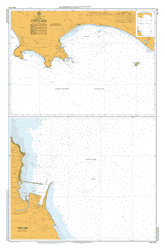
AUS 151 - Western Port (Entrance and North Arm) Nautical Chart
$49.95
Afterpay is only available for orders between $50.00 and $1000.00 More info
Frequently Asked Questions
What area does the AUS 151 - Western Port (Entrance and North Arm) Nautical Chart cover?
The AUS 151 - Western Port (Entrance and North Arm) Nautical Chart covers the waterway or coastal area described in the product title. Chart coverage area and scale are printed on the chart face. DPI charts are produced at standard nautical chart scales appropriate for safe navigation of Australian coastal and inland waterways.
Is this the most current edition of this chart?
Mapworld stocks the most current editions available. Marine charts are updated regularly — always supplement with current Notices to Mariners.
Is this chart suitable for coastal navigation?
Marine charts are essential tools for coastal passage planning. Always use alongside a GPS chartplotter, current Notices to Mariners, and appropriate navigation training.
Does Mapworld ship the AUS 151 - Western Port (Entrance and North Arm) Nautical Chart across Australia?
Yes, Mapworld ships Australia-wide. Standard shipping is a flat $7 rate, with free standard shipping on orders over $75. Express options are available at checkout. Most orders placed before 2pm AEST on weekdays are dispatched same day.
Related Items

© 2026 Mapworld. Website designed by Genie Media
X