- Australia ▾
- Topographic
▾
- Australia AUSTopo 250k (2025)
- Australia 50k Geoscience maps
- Australia 100k Geoscience maps
- Australia 250k Geoscience maps
- Australia 1:1m Geoscience maps
- New Zealand 50k maps
- New Zealand 250k maps
- New South Wales 25k maps
- New South Wales 50k maps
- New South Wales 100k maps
- Queensland 10k maps
- Queensland 25k maps
- Queensland 50k maps
- Queensland 100k maps
- Compasses
- Software
- GPS Systems
- Orienteering
- International ▾
- Wall Maps
▾
- World
- Australia & New Zealand
- Countries, Continents & Regions
- Historical
- Vintage National Geographic
- Australian Capital Territory
- New South Wales
- Northern Territory
- Queensland
- South Australia
- Tasmania
- Victoria
- Western Australia
- Celestial
- Children's
- Mining & Resources
- Wine Maps
- Healthcare
- Postcode Maps
- Electoral Maps
- Nautical ▾
- Flags
▾
- Australian Flag Sets & Banners
- Flag Bunting
- Handwavers
- Australian National Flags
- Aboriginal Flags
- Torres Strait Islander Flags
- International Flags
- Flagpoles & Accessories
- Australian Capital Territory Flags
- New South Wales Flags
- Northern Territory Flags
- Queensland Flags
- South Australia Flags
- Tasmania Flags
- Victoria Flags
- Western Australia Flags
- Gifts ▾
- Globes ▾
Dear valued customer. Please note that our checkout is not supported by old browsers. Please use a recent browser to access all checkout capabilities


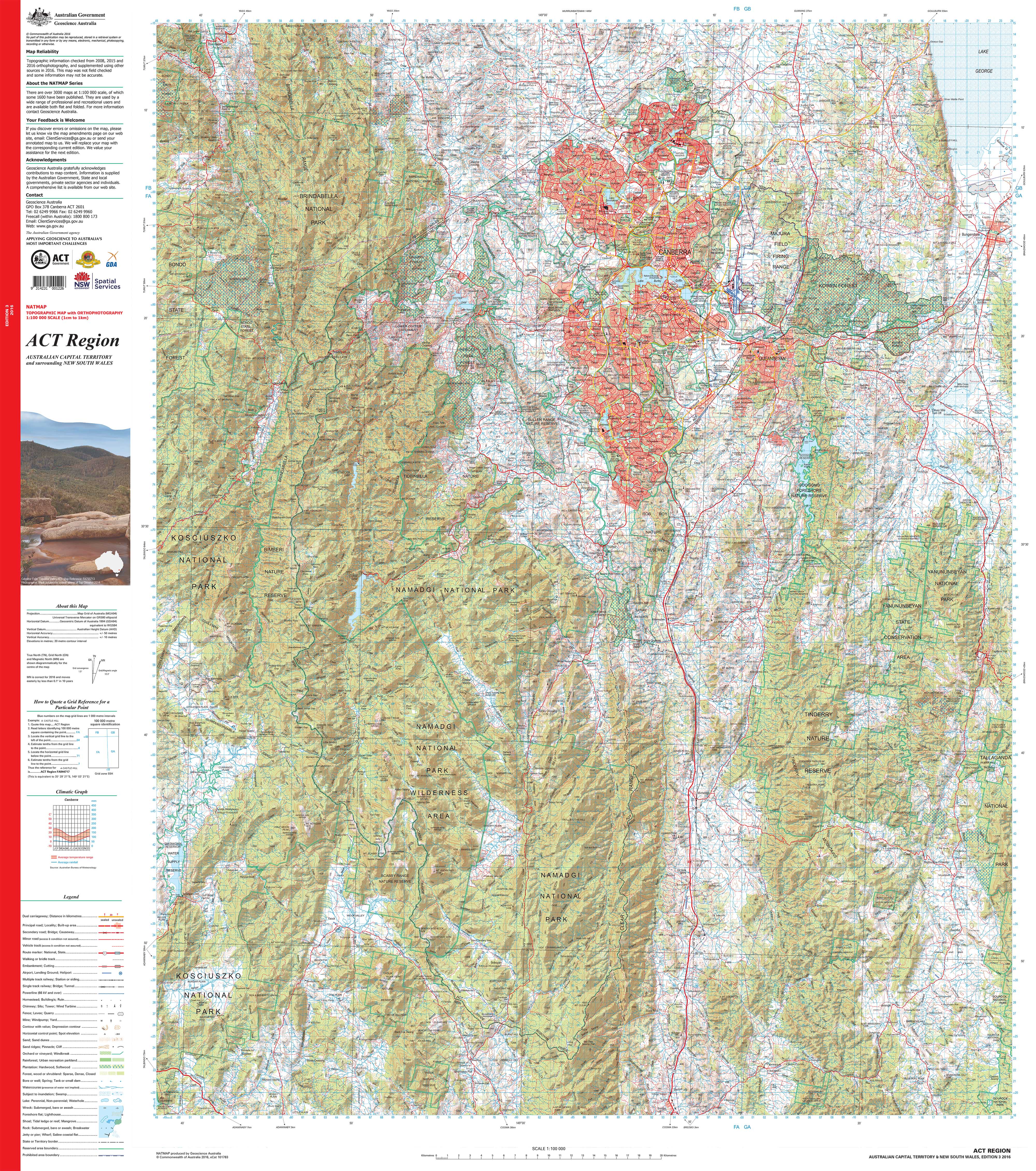
ACT Region Topographic 1:00k Wall Map
$69.95
or make 4 interest-free payments of
$17.49 AUD
fortnightly with
![]() More info
More info
ACT Region Topographic Wall Map — 1:100,000 Scale
Discover the Australian Capital Territory in striking clarity with this 1:100,000 topographic wall map — where 1 cm on the map equals 1 km on the ground. This professional-grade reference captures every contour, waterway, road, and landmark across the ACT, presenting the region in a way that is both practical and visually engaging.
Topographic maps remain one of the most trusted tools for understanding landscapes. This edition is no exception — used by 🚒 emergency services, 🌿 environmental managers, 🏗️ engineers, 🎓 educators, and outdoor enthusiasts alike. Whether you’re planning, teaching, exploring, or simply celebrating your connection to the Territory, this map is an invaluable and lasting resource.
Why it’s valued
-
Complete ACT coverage — Full regional detail at 1:100,000 scale.
-
Landscape clarity — Spot elevations, contour lines, rivers, creeks, and vegetation boundaries.
-
Human footprint — Roads, tracks, buildings, and administrative boundaries clearly marked.
-
Trusted reference — Used in emergency management, planning, engineering, and recreation.
-
Premium production — Printed on archival paper, laminated, or museum-grade canvas for a finish that lasts.
-
Australian made — Produced locally with pigment-based inks, colour-managed and hand-checked for accuracy.
Choose your finish
-
📄 Heavyweight Paper (160 gsm matte) — Archival quality; perfect for framing under glass in offices, classrooms, and homes.
-
💧 Laminated (True Encapsulation) — Encased in 2 × 80-micron gloss films; durable, wipe-clean, and built for everyday use.
-
🪵 Laminated + Timber Hang Rails — Lamination plus natural timber hang rails with top cord; ready to hang. Please allow up to 10 working days.
-
🎨 Archival Canvas (395 gsm HP Professional Matte) — Pigment-based, fade-resistant inks on museum-grade canvas for stunning clarity.
-
🪵 Canvas + Timber Hang Rails — Canvas finish with lacquered timber hang rails; a gallery-quality display. Please allow up to 10 working days.
Size (W × H)
-
920 mm × 1050 mm (36.2" × 41.3")
-
Orientation: Portrait
-
Aspect ratio: ~0.88 : 1
-
Framing tips: Mat windows should be cut 2–3 mm undersize for a snug fit; or float-mount with a ~3 mm reveal for a contemporary look.
-
Custom sizing: Available on request — contact us for tailored dimensions.
Specifications
| Attribute | Details |
|---|---|
| Title | ACT Region Topographic Wall Map |
| Scale | 1:100,000 (1 cm = 1 km) |
| Map Type | Topographic (Contours, hydrography, vegetation, boundaries, built features) |
| Print Size | 920 mm × 1050 mm |
| Available Finishes | Paper, Laminated, Laminated + Hang Rails, Canvas, Canvas + Hang Rails |
| Paper Weight | 160 gsm archival matte |
| Laminate | 2 × 80-micron gloss (true encapsulation) |
| Canvas Weight | 395 gsm HP Professional Matte |
| Inks | Pigment-based, fade-resistant |
| Optional Hang Rails | Natural timber, lacquered (allow up to 10 working days) |
| Origin | Printed in Australia |
Who it’s for
-
🚒 Emergency services & planners — Critical reference in operations and strategy.
-
🌿 Environmental & land managers — Track vegetation, waterways, and protected areas.
-
🏗️ Engineers & developers — Use accurate contours and features for infrastructure planning.
-
🎓 Educators & students — A teaching aid that makes geography real and tangible.
-
🥾 Outdoor enthusiasts — Hikers, campers, and locals who want to understand their landscape.
Our commitment
Every map is proudly 🇦🇺 printed in Australia using pigment-based, fade-resistant inks on premium materials. Each copy is colour-managed, hand-checked, and carefully packed to ensure it arrives in perfect condition.
🛒 Bring the ACT’s landscape into sharp relief with this professional-grade wall map — order today and enjoy a piece that’s as useful as it is beautiful.
Frequently Asked Questions
What are the dimensions of the ACT Region Topographic 1:00k Wall Map?
Mapworld wall maps range from standard 700×1000mm to large-format 1000×1430mm Supermaps. The exact dimensions for this map are shown in the product title. Where multiple sizes are available, select your preferred size when adding to cart.
Is this wall map available laminated?
Many Mapworld wall maps are available in paper, laminated, or framed finishes. Check the product options when adding to cart. Laminated maps are wipe-clean and more durable.
Is this the latest edition?
Mapworld stocks the most current editions available from all publishers. Edition year is shown in the product title where applicable. Mapworld updates its catalogue as new editions are released.
Can I write on or pin this wall map?
Laminated wall maps can be written on with whiteboard markers and wiped clean. Paper maps can be pinned on a corkboard. Choose a laminated option for a writeable surface.
Does Mapworld ship the ACT Region Topographic 1:00k Wall Map across Australia?
Yes, Mapworld ships Australia-wide. Standard shipping is a flat $7 rate, with free standard shipping on orders over $75. Express options are available at checkout. Most orders placed before 2pm AEST on weekdays are dispatched same day.
Related Items


© 2026 Mapworld. Website designed by Genie Media
X