- Australia ▾
- Topographic
▾
- Australia AUSTopo 250k (2025)
- Australia 50k Geoscience maps
- Australia 100k Geoscience maps
- Australia 250k Geoscience maps
- Australia 1:1m Geoscience maps
- New Zealand 50k maps
- New Zealand 250k maps
- New South Wales 25k maps
- New South Wales 50k maps
- New South Wales 100k maps
- Queensland 10k maps
- Queensland 25k maps
- Queensland 50k maps
- Queensland 100k maps
- Western Australia 25k maps
- Western Australia 50k maps
- Western Australia 100k maps
- Compasses
- Software
- GPS Systems
- International ▾
- Wall Maps
▾
- World
- Australia & New Zealand
- Countries, Continents & Regions
- Historical
- Vintage National Geographic
- Australian Capital Territory
- New South Wales
- Northern Territory
- Queensland
- South Australia
- Tasmania
- Victoria
- Western Australia
- Celestial
- Children's
- Mining & Resources
- Wine Maps
- Healthcare
- Postcode Maps
- Electoral Maps
- Nautical ▾
- Flags
▾
- Australian Flag Sets & Banners
- Flag Bunting
- Handwavers
- Australian National Flags
- Aboriginal Flags
- Torres Strait Islander Flags
- International Flags
- Flagpoles & Accessories
- Australian Capital Territory Flags
- New South Wales Flags
- Northern Territory Flags
- Queensland Flags
- South Australia Flags
- Tasmania Flags
- Victoria Flags
- Western Australia Flags
- Gifts ▾
- Globes ▾
Dear valued customer. Please note that our checkout is not supported by old browsers. Please use a recent browser to access all checkout capabilities



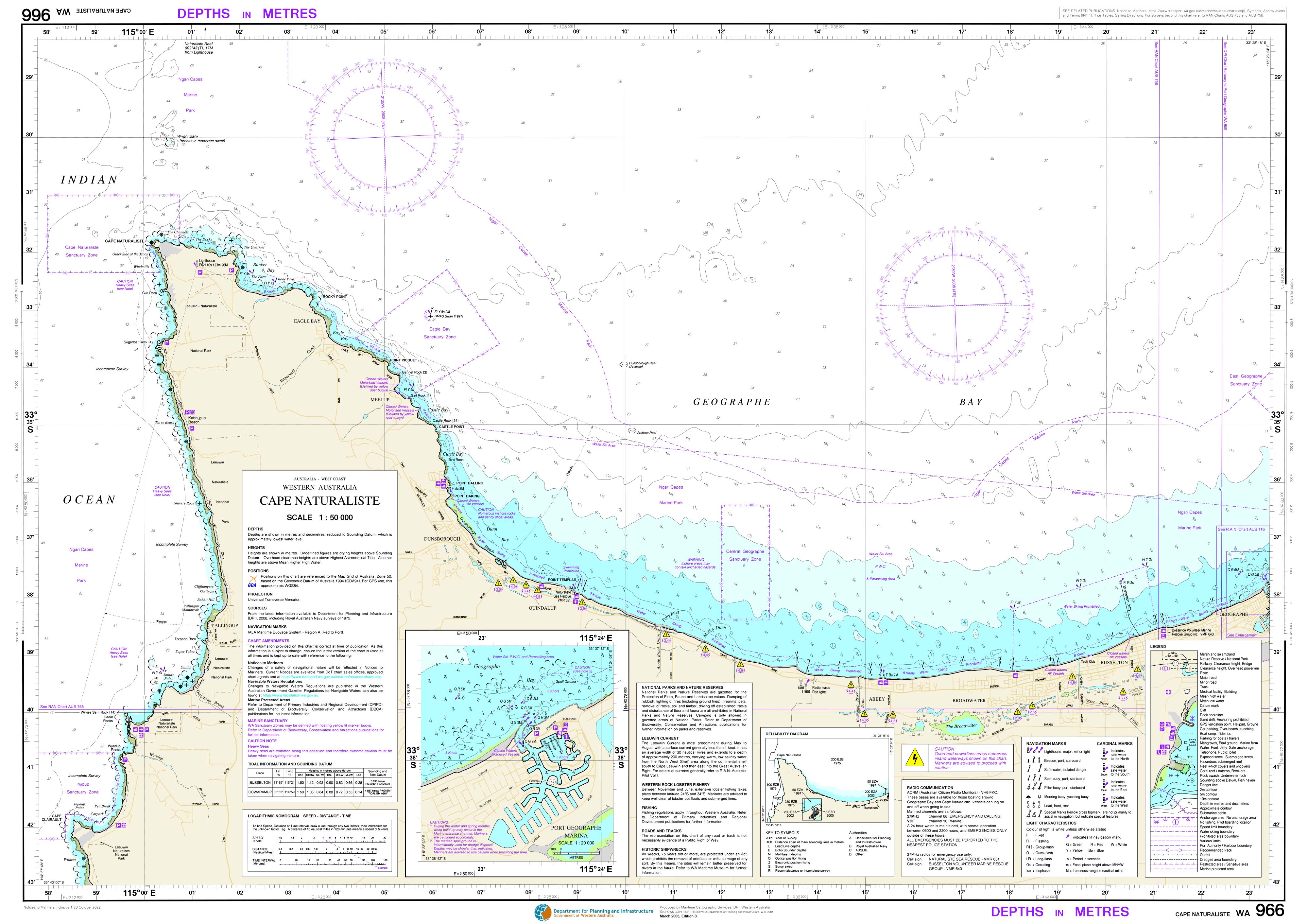
966 - Cape Naturaliste DPI Chart (2022)
$55.00
or make 4 interest-free payments of
$13.75 AUD
fortnightly with
 More info
966 — Cape Naturaliste (2022)
WA Department of Transport Nautical Chart
Essential coastal navigation for one of Western Australia’s most exposed and dynamic headlands.
🚤 Navigate Cape Naturaliste with Local Authority Confidence
Chart 966 — Cape Naturaliste (2022) is a detailed nautical chart published by the Western Australian Department of Transport to support safe recreational and local commercial boating along the Cape Naturaliste coastline.
Covering the waters surrounding Cape Naturaliste, this chart is designed for skippers operating in high-energy coastal conditions, where swell, current, reefs, and exposure combine to demand careful planning and precise navigation.
🧭 Why Skippers Rely on This Chart
-
⚓ Authoritative WA source — Published by the Department of Transport
-
🗺️ Coastal-scale clarity (1:50,000) — Ideal for near-shore and open-water navigation
-
🚦 Navigation aids clearly shown — Lights, beacons, piles & limits
-
🌊 Depth soundings & seabed detail — Critical near reefs and headlands
-
🚤 Hazard awareness — Supports safe passage in exposed waters
-
🇦🇺 Printed locally in Australia — Crisp colour and professional finish
The chart is compiled to specifications based on those of the International Hydrographic Organisation (IHO), ensuring professional cartographic standards and consistent presentation.
🧠 Why Cape Naturaliste Demands a Dedicated Chart
Cape Naturaliste sits at a junction of strong swell, shifting weather, and rugged seabed features. This chart helps skippers:
-
Plan safe coastal transits around an exposed headland
-
Identify reefs, shoals, and depth changes
-
Navigate confidently in open-water conditions
-
Understand nautical limits and navigation aids
-
Combine passage planning with on-water situational awareness
This is a working navigation tool, not a decorative map.
👥 Who This Chart Is For
-
🚤 Recreational skippers boating the South West coast
-
🎣 Fishers operating near reef edges and headlands
-
🛥️ Local commercial operators
-
🧭 Charter operators & boating clubs
-
🗂️ Marine planners and educators
-
🎁 A practical coastal gift for serious WA boaters
If your boating takes you past Cape Naturaliste, this chart should be on board.
🗺️ What You’ll See on the Chart
Clear, concise, and navigationally relevant information, including:
-
Accurate depth soundings
-
Coastal and seabed features
-
Navigation aids (lights, beacons, piles)
-
Marked nautical limits
-
Identified hazards and obstructions
-
Reference points for safe coastal passage planning
Mariners should keep charts current by regularly consulting relevant Notices to Mariners.
🖨️ Field-Ready Print Options
Choose the finish that suits how you boat:
📄 Paper (Standard)
-
Full-colour print on quality paper
-
Ideal for chart tables, planning, or protected use
💧 Waterproof DuPont™ Tyvek®
-
Tear-proof, water-resistant & foldable
-
Will not disintegrate when wet
-
Ideal for on-board coastal navigation
✍️ Laminated (Write-On / Wipe-Off)
-
True encapsulation for durability
-
Draw routes with whiteboard marker
-
Apply map dots without permanent marks
-
Resistant to tears, stains, and heavy handling
📐 Chart Specifications
| Detail | Information |
|---|---|
| Chart Number | 966 |
| Title | Cape Naturaliste |
| Edition | 2022 |
| Publisher | WA Department of Transport |
| Scale | 1:50,000 |
| Format | Single-sided sheet |
| Sheet Size | 840 mm × 590 mm |
| Colour | Full colour |
| Use | Recreational & local commercial boating |
| Production | Printed in Australia |
⚠️ Important Navigation Notice
These Department of Transport charts do not meet Australian or international chart carriage requirements, including SOLAS V.
For compliance-grade navigation, mariners must use official charts published by the Australian Hydrographic Service or UK Admiralty.
This chart is intended for planning, reference, and local navigation awareness, where detailed coastal knowledge is essential.
🇦🇺 Our Commitment
At Mapworld, we print charts locally in Australia using professional-grade materials and marine-ready finishes. Every chart is carefully handled and checked—ready for real boating use in exposed coastal conditions.
🧭 Ready to navigate Cape Naturaliste with confidence?
Select your preferred finish and add Chart 966 — Cape Naturaliste (2022) to your kit today.
Frequently Asked Questions
What area does the 966 - Cape Naturaliste DPI Chart (2022) cover?
The 966 - Cape Naturaliste DPI Chart (2022) covers the waterway or coastal area described in the product title. Chart coverage area and scale are printed on the chart face. DPI charts are produced at standard nautical chart scales appropriate for safe navigation of Australian coastal and inland waterways.
Is this the most current edition of this chart?
Mapworld stocks the most current editions available. Marine charts are updated regularly — always supplement with current Notices to Mariners.
Is this chart suitable for coastal navigation?
Marine charts are essential tools for coastal passage planning. Always use alongside a GPS chartplotter, current Notices to Mariners, and appropriate navigation training.
Does Mapworld ship the 966 - Cape Naturaliste DPI Chart (2022) across Australia?
Yes, Mapworld ships Australia-wide. Standard shipping is a flat $7 rate, with free standard shipping on orders over $75. Express options are available at checkout. Most orders placed before 2pm AEST on weekdays are dispatched same day.
Related Items



© 2026 Mapworld. Website designed by Genie Media


X