- Australia ▾
- Topographic
▾
- Australia AUSTopo 250k (2025)
- Australia 50k Geoscience maps
- Australia 100k Geoscience maps
- Australia 250k Geoscience maps
- Australia 1:1m Geoscience maps
- New Zealand 50k maps
- New Zealand 250k maps
- New South Wales 25k maps
- New South Wales 50k maps
- New South Wales 100k maps
- Queensland 10k maps
- Queensland 25k maps
- Queensland 50k maps
- Queensland 100k maps
- Compasses
- Software
- GPS Systems
- Orienteering
- International ▾
- Wall Maps
▾
- World
- Australia & New Zealand
- Countries, Continents & Regions
- Historical
- Vintage National Geographic
- Australian Capital Territory
- New South Wales
- Northern Territory
- Queensland
- South Australia
- Tasmania
- Victoria
- Western Australia
- Celestial
- Children's
- Mining & Resources
- Wine Maps
- Healthcare
- Postcode Maps
- Electoral Maps
- Nautical ▾
- Flags
▾
- Australian Flag Sets & Banners
- Flag Bunting
- Handwavers
- Australian National Flags
- Aboriginal Flags
- Torres Strait Islander Flags
- International Flags
- Flagpoles & Accessories
- Australian Capital Territory Flags
- New South Wales Flags
- Northern Territory Flags
- Queensland Flags
- South Australia Flags
- Tasmania Flags
- Victoria Flags
- Western Australia Flags
- Gifts ▾
- Globes ▾
Dear valued customer. Please note that our checkout is not supported by old browsers. Please use a recent browser to access all checkout capabilities


World Wall Maps
World wall maps offer a striking and informative way to see the entire globe at a glance—perfect for bringing perspective, colour, and context to any space. These maps showcase countries, continents, oceans, borders, cities, and key geographic features with clarity and style, making them ideal for everything from education and travel planning to business strategy and décor.
Our collection includes a wide range of styles—from detailed political and physical maps to minimalist modern designs and vintage-inspired classics—available in various sizes and finishes to suit your needs. Whether you're decorating a classroom, office, study, or living space, a world wall map provides a global view that’s both beautiful and practical.


About World Wall Maps
A world wall map is one of the most versatile pieces of cartography you can own — equal parts reference tool, decorative feature, conversation starter, and educational aid. Mapworld stocks over 200 world wall maps spanning every major publisher, every projection, every size from A2 to 2.3-metre Mega Maps, and every format from paper through laminated, mounted, framed and canvas.
World Map Types Explained
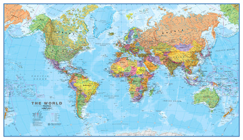
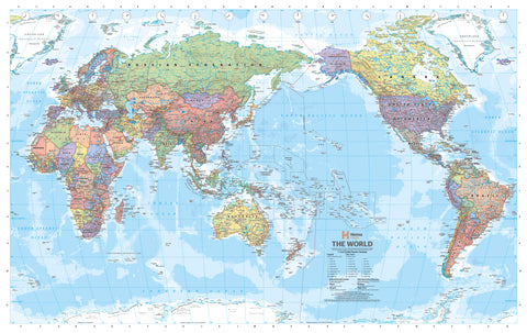
Political World Maps
The most common world wall map style — country borders shown in distinct colours, with capital cities, major cities, rivers, mountain ranges and other reference data. Best for offices, classrooms, sales-territory work, current-affairs reference, or anywhere borders and country names matter. Our top sellers in this category are the Cosmographics Political Supermap (1440 × 840mm), Cosmographics Political Mega Map (2150 × 1270mm), and the National Geographic World Classic.
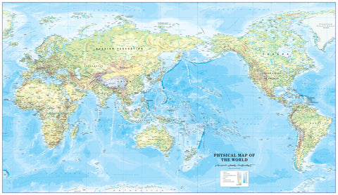
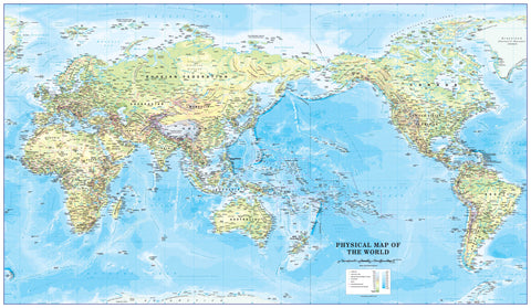
Physical World Maps
Terrain-focused maps using shaded relief to show mountains, ocean depths, deserts and physical features rather than political borders. Best for geography, earth science, classrooms, decorative use, and anyone who finds the planet's physical structure more interesting than its politics. Cosmographics Physical World Map and the National Geographic Physical Atlas of the World are the standards.
Pacific-Centred Maps
Standard world maps published overseas put Europe and Africa in the centre, splitting the Pacific Ocean down both edges. For Australian audiences this is upside-down (literally — Australia ends up at the bottom edge of the map). Pacific-centred maps put Australia and the Pacific Rim in the centre where they belong. Cosmographics is the Australian-publishing specialist for Pacific-centred maps, with Classic, Supermap, Mega Map and personal-size versions all available. Hema also publishes a strong Pacific-centred range.
Antique & Vintage Reproductions
Decorative reproductions of historical world maps for studies, libraries, restaurants, and feature walls. The standout pieces:
- Gleason's New Standard Map of the World (1892) — the famous "flat earth" projection map, intentionally historical
- Stanford's General Map of the World (1920) — classic British colonial-era cartography
- Captain Cook's World Map (1801) — period reproduction
- Monte's Planisphere (1587) — Renaissance-era flat earth map
- National Geographic 1960 — mid-century reference style
These are decorative pieces, intentionally historical — they don't reflect modern political boundaries.
Children's & Educational Maps
Designed specifically for kids' rooms, classrooms and primary education. The National Geographic World for Kids (914 × 610mm) is the standard, with illustrated content and animal locations. The Children's World Wall Map by Collins and the Children's Physical Map of the World are popular alternatives.
Scratch & Travel Tracking Maps
Foil-coated world maps where you scratch off countries you've visited to reveal coloured detail underneath — equal parts gift item and decoration. The World & Flags Deluxe Scratch Map and the standard World Scratch Map are the most popular.
Specialty & Themed World Maps
- Gall-Peters Equal Area — area-accurate projection where Africa appears at its true relative size
- Hema Upside-Down World Map — Australia on top, just because
- World Wall Map of Global Shipping Routes — for logistics and supply chain
- World Population Map — population-density visualisation
- Pacific-Centred World Wall Map — alternative projections
Format & Size Options
| Format | Best for |
|---|---|
| Paper | Classrooms, casual reference, lower price point. Ships rolled. |
| Laminated | Most office and home use. Whiteboard-marker compatible. Ships rolled in tube. |
| Laminated with hang rails | Permanent display where you want a polished, gallery-style finish without framing. |
| Canvas | Premium decorative pieces — feature walls, boardrooms, restaurants. |
| Framed | Ready to hang, premium decorative finish. Limited size options vs laminated. |
Size guide
- A2 / A1 (around 600 × 420mm to 840 × 600mm) — small offices, kids' rooms, study walls, boardroom side walls
- Standard wall map (around 1000 × 700mm) — most home offices, classrooms, average-sized meeting rooms
- Supermap / 1.4m (around 1440 × 840mm) — large home offices, generous wall sections, sales floors
- Mega Map / 2m+ (2150 × 1270mm and up) — boardrooms, large foyers, statement walls
Always measure the wall first and allow ~30cm of breathing room on each side.
Publishers — Who Makes What
- Cosmographics — Australian publisher, the standard for Pacific-centred political and physical wall maps. Top-revenue brand on Mapworld for world maps.
- Hema — Australian touring specialist, with a strong world wall map range including Pacific-centred classic, Supermap and Mega Map formats
- National Geographic — premium American cartography. Classic Political, Physical Atlas, Executive Mural, and the World for Kids range
- Maps International — UK publisher with high-quality political, physical and antique reproductions
- Stanfords — historic British map publisher, source for many of our antique reproductions
- Collins — British educational publisher, Children's World Wall Map
- Atlas of the World — UK educational range, Physical World Map
Why Buy World Wall Maps from Mapworld
- Largest world wall map range in Australia — over 200 in-stock world wall maps
- Pacific-centred specialists — comprehensive Cosmographics and Hema Pacific range, including the largest formats
- Current editions from Cosmographics (2024 and 2025), National Geographic, Hema and Maps International
- Free shipping over $75 Australia-wide, flat $7 below that. Same-day Perth dispatch on weekday orders before 2 pm AWST
- Custom mapping service — branded world maps, sales-territory overlays, supply chain visualisation
- Knowledgeable support — call 1300 795 697 if you need help choosing format, size or projection
Frequently Asked Questions
What size world wall map should I buy?
For most home offices and classrooms, the standard 1000 × 700mm size is right. For larger sales floors, generous home walls, or feature areas, the Cosmographics Supermap (1440 × 840mm) is the sweet spot — readable from across a large room. For boardrooms, foyers and statement walls, the Mega Map (2150 × 1270mm) is the largest format we stock. Always measure your wall first and allow 30cm of breathing room on each side.
What is a Pacific-centred world map?
Standard world maps put Europe and Africa in the centre and split the Pacific Ocean down both edges. Pacific-centred maps put Australia and the Pacific Rim in the centre — which makes much more sense for Australian audiences. Cosmographics is the Australian-publishing specialist for Pacific-centred maps; Hema also publishes a strong Pacific range.
Should I buy paper, laminated, mounted or framed?
Laminated is the most flexible — ships rolled, edges sealed, you can write on it with whiteboard marker, and it lasts decades. Framed is the easiest — arrives ready to hang and looks polished. Canvas is for premium decorative use. Paper is the lowest-price option, ideal for classrooms or casual reference. For most home and office buyers, laminated is the right starting point.
Are these the latest editions of world wall maps?
Yes for current-affairs maps. Cosmographics, National Geographic, Hema and Maps International all reissue their world maps every one to three years to reflect current borders and country names. Each product page lists the edition year. Antique and vintage reproductions are intentionally historical and do not reflect modern political boundaries.
Do you ship world wall maps Australia-wide?
Yes. Wall maps over A2 ship rolled in a sturdy tube via tracked courier. Smaller maps ship as standard parcel. Most Australian metro deliveries arrive in 2 to 5 business days. Free shipping on orders over $75; flat $7 below that. Express options at checkout.
Can I get a custom world wall map?
Yes. Mapworld runs a custom mapping service for businesses needing branded world maps with sales-territory overlays, supply chain routing, regional offices marked, customer distribution by country, or any other business-specific layer. Call 1300 795 697 to discuss your requirements.
© 2026 Mapworld. Website designed by Genie Media
X