- Australia ▾
- Topographic
▾
- Australia AUSTopo 250k (2025)
- Australia 50k Geoscience maps
- Australia 100k Geoscience maps
- Australia 250k Geoscience maps
- Australia 1:1m Geoscience maps
- New Zealand 50k maps
- New Zealand 250k maps
- New South Wales 25k maps
- New South Wales 50k maps
- New South Wales 100k maps
- Queensland 10k maps
- Queensland 25k maps
- Queensland 50k maps
- Queensland 100k maps
- Compasses
- Software
- GPS Systems
- Orienteering
- International ▾
- Wall Maps
▾
- World
- Australia & New Zealand
- Countries, Continents & Regions
- Historical
- Vintage National Geographic
- Australian Capital Territory
- New South Wales
- Northern Territory
- Queensland
- South Australia
- Tasmania
- Victoria
- Western Australia
- Celestial
- Children's
- Mining & Resources
- Wine Maps
- Healthcare
- Postcode Maps
- Electoral Maps
- Nautical ▾
- Flags
▾
- Australian Flag Sets & Banners
- Flag Bunting
- Handwavers
- Australian National Flags
- Aboriginal Flags
- Torres Strait Islander Flags
- International Flags
- Flagpoles & Accessories
- Australian Capital Territory Flags
- New South Wales Flags
- Northern Territory Flags
- Queensland Flags
- South Australia Flags
- Tasmania Flags
- Victoria Flags
- Western Australia Flags
- Gifts ▾
- Globes ▾
Dear valued customer. Please note that our checkout is not supported by old browsers. Please use a recent browser to access all checkout capabilities


Wall Maps
Browse Australia's largest range of wall maps — World, Australia, state, regional and themed — in laminated, framed, canvas, paper and scratch-off finishes. Whether you're outfitting a classroom, an office boardroom or marking off your travels at home, sizes range from A2 desk-prints up to 2-metre statement pieces. All wall maps ship from our Perth warehouse with free shipping on orders over $75.


Choosing the right wall map
The right wall map depends on three things: what it should show, where it'll hang, and how you want it finished.
For a classroom, boardroom or family room, a political world map at 1.2m × 0.9m is the most popular choice — readable across the room, fits a standard wall section. For an office or study, an Australia wall map at the same size keeps you focused on the local market. For travellers, a scratch-off world map turns the wall into a record of where you've been.
Browse by region
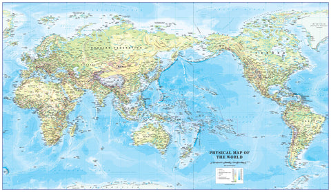
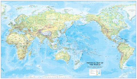
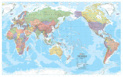
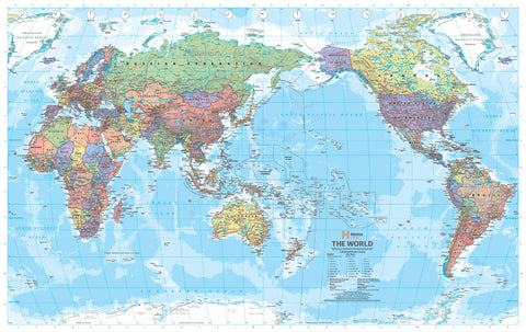
- World wall maps — political, physical, antique and Pacific-centred
- Australia & New Zealand wall maps — Hema, Cosmographics, UBD
- Countries, continents & regions — Europe, Asia, North America, Africa and more
Australian states & territories
- New South Wales
- Victoria
- Queensland
- South Australia
- Western Australia
- Tasmania
- Northern Territory
- Australian Capital Territory
Browse by theme
- Historical wall maps — antique-style cartography
- Vintage National Geographic — original NGS plates
- Celestial maps — star charts and constellation maps
- Children's wall maps — bright, durable, designed for learning
- Postcode maps — for sales territories and logistics
- Electoral maps — federal and state boundaries
- Wine region maps — for cellars, restaurants, bars
- Mining & resources — tenement and exploration maps
- Scratch-off maps — record where you've been
Browse by finish
- Paper — lightest, lowest-cost, best for short-term or pinning to corkboard
- Laminated — ships rolled, write on it with whiteboard marker, wipe clean, lasts decades
- Framed / canvas — ready-to-hang, gallery-style finish
- Hang rail — wood or metal rails top and bottom, classroom and shopfit standard
Featured publishers
- National Geographic — gold-standard cartography, executive map series and vintage editions
- Hema — Australian publisher, the standard for Australia road and 4WD wall maps
- Cosmographics — UK publisher specialising in tubed political and physical world maps
- UBD Gregory's — Australian state, postcode and electoral wall maps
Free shipping on orders over $75, $7 standard postage Australia-wide, and same-day dispatch from Perth before 2pm AWST.
Frequently asked questions
What size wall map should I buy?
For most living rooms, classrooms and offices, 1.2m × 0.9m is the sweet spot — readable from across the room, fits standard wall sections. Boardrooms and large halls suit 1.5m+. Studies, kids' rooms and corridors suit A1 or A2 (~84cm × 59cm). Measure your wall and allow 30cm of breathing room each side.
Should I buy a laminated or framed wall map?
Laminated is the most flexible — ships rolled, edges sealed, you can write on it with whiteboard marker, lasts decades. Framed is the easiest — arrives ready to hang, looks polished. If you'll mark places on the map (travel, sales territories, project sites), choose laminated. If purely decorative, choose framed.
Do you ship wall maps Australia-wide?
Yes. Wall maps over A2 ship rolled in a sturdy tube via tracked courier. Smaller maps ship as standard parcel. Most Australian metro deliveries arrive in 2–5 business days. Free shipping on orders over $75.
Are these maps current editions?
Yes. World and Australia wall maps from major publishers — National Geographic, Hema, Cosmographics, UBD Gregory's — are reissued every 1–3 years. Each product listing shows the current edition. Antique and vintage maps are intentionally historical.
Do you offer custom or branded wall maps?
Yes. Mapworld runs a custom mapping service for businesses needing branded, modified or reprojected wall maps — sales-territory overlays, postcode and electoral colouring, mining tenement layers, healthcare service-area maps. Get in touch.
Hema regional wall maps
Postcode and territory wall maps
For business and government use, our postcode wall map range covers every Australian state and major metro — ideal for sales territories, real estate boundaries, marketing analysis, and service catchments. Laminated for whiteboard markup.
For 4WD enthusiasts, caravan travellers, or anyone planning Australian outback adventures, Hema produces a dedicated range of laminated regional wall maps in standard, Supermap, and Megamap formats — Cape York, Kimberley, Pilbara, Flinders Ranges, the Victorian High Country, and more. Browse the full Hema Maps Australia range, or jump straight to the giant Hema laminated wall maps collection.
For world maps specifically, browse our dedicated World Wall Map range — Pacific-centred political and physical maps, antique reproductions, scratch maps and large-format Mega Maps from Cosmographics, Hema, National Geographic and Maps International.
© 2026 Mapworld. Website designed by Genie Media
X