

Physical & Political Detail | Guiana Shield & Coastline | Premium Finishes
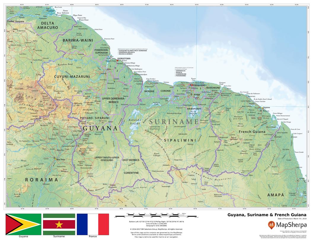
From the rainforest-draped Guiana Shield to the mangrove-edged Atlantic coast, this wall map brings Guyana, Suriname, and French Guiana into crisp focus. Elegant shaded relief and elevation tints reveal plateaus, uplands, and coastal lowlands, while clear political boundaries and labels make regional understanding effortless—perfect for classrooms, offices, and travel-inspired interiors.
🗺️ Map Features
-
Tri-Territory Coverage – Full depiction of Guyana, Suriname, and French Guiana with surrounding Venezuela and Brazil for geographic context.
-
Capitals & Major Cities – Georgetown, Paramaribo, and Cayenne plus key towns and settlements for easy orientation.
-
Relief Shading & Elevation Colours – Hypsometric tints highlight the Pakaraima and Tumuc-Humac ranges, interior plateaus, and river basins.
-
Rivers, Coasts & Wetlands – The Essequibo, Demerara, Berbice, Suriname, Maroni, and Oyapock rivers, deltas, and coastal features clearly shown.
-
Transport & Reference – Primary roads (where depicted), borders, protected areas, and a balanced label hierarchy for clarity without clutter at wall distance.
All features appear as depicted on the printed map.
✨ Available Finishes
| Format | Description |
|---|---|
| 📜 Paper (160 gsm) | Heavyweight matte-coated paper—ideal for framing under glass. |
| 🧼 Laminated (Encapsulated) | Fully sealed in 80-micron gloss laminate—durable, wipe-clean, classroom-ready. |
| 🪵 Laminated with Wooden Hang Rails | Laminated map mounted with lacquered natural timber rails (top & bottom) and a hanging cord—ready to display. |
| 🖼️ Canvas (395 gsm) | HP Professional Matte Canvas with archival pigment-based inks—rich texture, fade-resistant, gallery-grade. |
| 🪵 Canvas with Wooden Hang Rails | Canvas finished with lacquered timber rails and a hanging cord—timeless, frame-free presentation. |
🔨 Hang-railed maps are made to order—please allow up to 10 working days for professional mounting.
📐 Specifications
| Feature | Detail |
|---|---|
| Title | Guyana, Suriname & French Guiana Wall Map |
| Map Type | Physical / Political |
| Scale | 1:2,500,000 (≈ 1 cm = 25 km) |
| Dimensions | 1118 mm (W) × 864 mm (H) |
| Orientation | Landscape |
| Materials | Paper, Laminated, Canvas, With or Without Timber Rails |
| Printing | Archival pigment-based inks, fade-resistant |
💡 Why You’ll Love It
-
Rainforest-to-coast clarity—uplands, rivers, and shorelines rendered in refined shaded relief.
-
Clean political framing for teaching, planning, and presentations.
-
Five premium finishes to suit homes, offices, and classrooms.
-
Built to last—laminated and canvas options resist wear while keeping colours true.
🚚 Delivery
-
Paper, Laminated & Canvas (rolled): Usually ships within 1–2 business days.
-
Hang-railed versions: Made to order; allow up to 10 working days.
-
Packaging: Securely protected to arrive in pristine condition.
Celebrate the rich landscapes of the Guianas—where great rivers meet the Atlantic. Choose your finish, hang with ease, and enjoy a map that’s both beautiful and deeply useful.


