- Australia ▾
- Topographic
▾
- Australia AUSTopo 250k (2025)
- Australia 50k Geoscience maps
- Australia 100k Geoscience maps
- Australia 250k Geoscience maps
- Australia 1:1m Geoscience maps
- New Zealand 50k maps
- New Zealand 250k maps
- New South Wales 25k maps
- New South Wales 50k maps
- New South Wales 100k maps
- Queensland 10k maps
- Queensland 25k maps
- Queensland 50k maps
- Queensland 100k maps
- Western Australia 25k maps
- Western Australia 50k maps
- Western Australia 100k maps
- Compasses
- Software
- GPS Systems
- International ▾
- Wall Maps
▾
- World
- Australia & New Zealand
- Countries, Continents & Regions
- Historical
- Vintage National Geographic
- Australian Capital Territory
- New South Wales
- Northern Territory
- Queensland
- South Australia
- Tasmania
- Victoria
- Western Australia
- Celestial
- Children's
- Mining & Resources
- Wine Maps
- Healthcare
- Postcode Maps
- Electoral Maps
- Nautical ▾
- Flags
▾
- Australian Flag Sets & Banners
- Flag Bunting
- Handwavers
- Australian National Flags
- Aboriginal Flags
- Torres Strait Islander Flags
- International Flags
- Flagpoles & Accessories
- Australian Capital Territory Flags
- New South Wales Flags
- Northern Territory Flags
- Queensland Flags
- South Australia Flags
- Tasmania Flags
- Victoria Flags
- Western Australia Flags
- Gifts ▾
- Globes ▾
Dear valued customer. Please note that our checkout is not supported by old browsers. Please use a recent browser to access all checkout capabilities


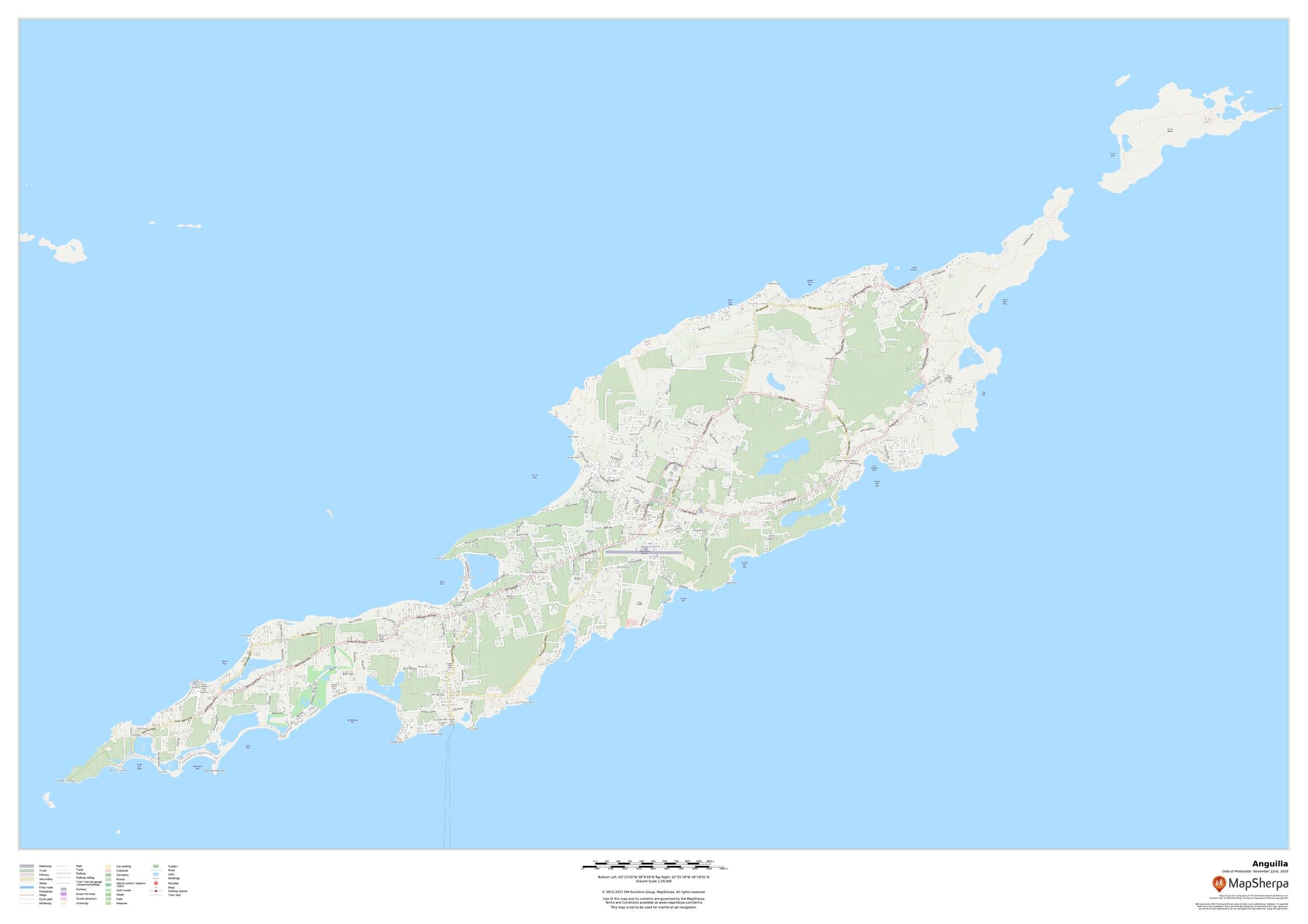
Anguilla Wall Map 1189 x 841mm
$79.95
or make 4 interest-free payments of
$19.99 AUD
fortnightly with
![]() More info
More info
1189 x 841mm | Detailed Road & Infrastructure Network | Premium Cartographic Design
This detailed map of Anguilla offers an in-depth view of the island, highlighting its road network, land use, points of interest, and key buildings. From the capital of The Valley to walking paths and infrastructure, this map serves as an invaluable resource for travellers or as a decorative wall piece for your home. With its meticulous detailing, this map is perfect for anyone interested in the island’s geography and local features.
🗺️ Key Features of the Anguilla Wall Map
🌍 Comprehensive Geographic Coverage
-
Full road network, including major roads and local streets.
-
The Valley—the capital of Anguilla, with key buildings and landmarks clearly identified.
-
Walking paths, parks, and points of interest like beaches, tourist attractions, and cultural landmarks.
-
Land use categories showing residential, commercial, and public spaces.
🌄 Detailed Infrastructure
-
Major infrastructure networks like airports, ferries, and marinas.
-
City planning features with details on public buildings and tourist destinations.
📌 Why You’ll Love This Map
-
✔️ Educational & Informative:
Perfect for tourists, residents, and anyone looking to explore Anguilla’s geography and infrastructure. -
✔️ Visually Stunning:
The clear road networks, elevations, and land use details create a map that is both informative and beautiful. -
✔️ Durable & Long-Lasting:
Choose from paper, laminated, or canvas finishes to suit your needs and ensure lasting quality. -
✔️ Ideal for Home & Office Decor:
Adds a sophisticated and functional touch to any office, home study, or living room.
🖼️ Premium Finishing Options
Choose the best finish to suit your style and requirements:
| Format | Description |
|---|---|
| 📜 Paper (160 gsm) | Printed on heavyweight matte-coated paper—ideal for framing under glass. Traditional and professional. |
| 🧼 Laminated (Encapsulated) | Fully sealed in 80-micron gloss laminate for durability and easy cleaning—perfect for active environments. |
| 🪵 Laminated with Wooden Hang Rails | Laminated version mounted with natural timber rails (top and bottom) and a sturdy hanging cord. Ready to hang immediately. |
| 🖼️ Canvas (395 gsm) | Printed on HP Professional Matte Canvas with pigment-based inks. Fade-resistant, richly textured, and archival quality for long-lasting beauty. |
| 🪵 Canvas with Wooden Hang Rails | Elegant canvas mounted with lacquered timber rails and hanging cord—perfect for a gallery-style display. |
🔨 Note: Please allow up to 10 working days for delivery of hang-railed maps, as each is professionally mounted by our expert framer.
📐 Specifications
| Feature | Detail |
|---|---|
| Title | Anguilla Wall Map – Road & Infrastructure Network |
| Map Type | Political / Road Network |
| Scale | 1:24,000 |
| Dimensions | 1189 mm (W) x 841 mm (H) |
| Material Options | Paper, Laminated, Canvas, With or Without Timber Rails |
| Made In | Australia |
🎁 A Unique Gift For…
-
🌍 Travel Enthusiasts: Perfect for those planning to visit or explore Anguilla.
-
🌍 Local Residents: An invaluable tool for Anguillans looking to navigate their island’s roads and landmarks.
-
🌍 Geography & Cartography Enthusiasts: Ideal for those interested in island geography and topographic features.
-
🌍 Home & Office Decor: Adds a touch of sophistication and functional beauty to your living room, office, or study.
🚚 Delivery & Framing Notes
-
Paper, Laminated, and Canvas (rolled) maps: Ships within 1–2 business days.
-
Hang-railed maps: Made to order—please allow up to 10 working days for production.
-
All maps are securely packaged in protective packaging to ensure safe delivery.
🌍 Explore Anguilla Like Never Before
This Anguilla Wall Map is a detailed, visually appealing reference to the island’s infrastructure, road networks, and land features. Perfect for tourists, residents, and those interested in exploring Anguilla’s rich geography and landmarks.
👉 Order yours today and start discovering the beauty and layout of Anguilla!
Frequently Asked Questions
What are the dimensions of the Anguilla Wall Map 1189 x 841mm?
Mapworld wall maps range from standard 700×1000mm to large-format 1000×1430mm Supermaps. The exact dimensions for this map are shown in the product title. Where multiple sizes are available, select your preferred size when adding to cart.
Is this wall map available laminated?
Many Mapworld wall maps are available in paper, laminated, or framed finishes. Check the product options when adding to cart. Laminated maps are wipe-clean and more durable.
Is this the latest edition?
Mapworld stocks the most current editions available from all publishers. Edition year is shown in the product title where applicable. Mapworld updates its catalogue as new editions are released.
Can I write on or pin this wall map?
Laminated wall maps can be written on with whiteboard markers and wiped clean. Paper maps can be pinned on a corkboard. Choose a laminated option for a writeable surface.
Does Mapworld ship the Anguilla Wall Map 1189 x 841mm across Australia?
Yes, Mapworld ships Australia-wide. Standard shipping is a flat $7 rate, with free standard shipping on orders over $75. Express options are available at checkout. Most orders placed before 2pm AEST on weekdays are dispatched same day.
Related Items


© 2026 Mapworld. Website designed by Genie Media
X