- Australia ▾
- Topographic
▾
- Australia AUSTopo 250k (2025)
- Australia 50k Geoscience maps
- Australia 100k Geoscience maps
- Australia 250k Geoscience maps
- Australia 1:1m Geoscience maps
- New Zealand 50k maps
- New Zealand 250k maps
- New South Wales 25k maps
- New South Wales 50k maps
- New South Wales 100k maps
- Queensland 10k maps
- Queensland 25k maps
- Queensland 50k maps
- Queensland 100k maps
- Western Australia 25k maps
- Western Australia 50k maps
- Western Australia 100k maps
- Compasses
- Software
- GPS Systems
- International ▾
- Wall Maps
▾
- World
- Australia & New Zealand
- Countries, Continents & Regions
- Historical
- Vintage National Geographic
- Australian Capital Territory
- New South Wales
- Northern Territory
- Queensland
- South Australia
- Tasmania
- Victoria
- Western Australia
- Celestial
- Children's
- Mining & Resources
- Wine Maps
- Healthcare
- Postcode Maps
- Electoral Maps
- Nautical ▾
- Flags
▾
- Australian Flag Sets & Banners
- Flag Bunting
- Handwavers
- Australian National Flags
- Aboriginal Flags
- Torres Strait Islander Flags
- International Flags
- Flagpoles & Accessories
- Australian Capital Territory Flags
- New South Wales Flags
- Northern Territory Flags
- Queensland Flags
- South Australia Flags
- Tasmania Flags
- Victoria Flags
- Western Australia Flags
- Gifts ▾
- Globes ▾
Dear valued customer. Please note that our checkout is not supported by old browsers. Please use a recent browser to access all checkout capabilities


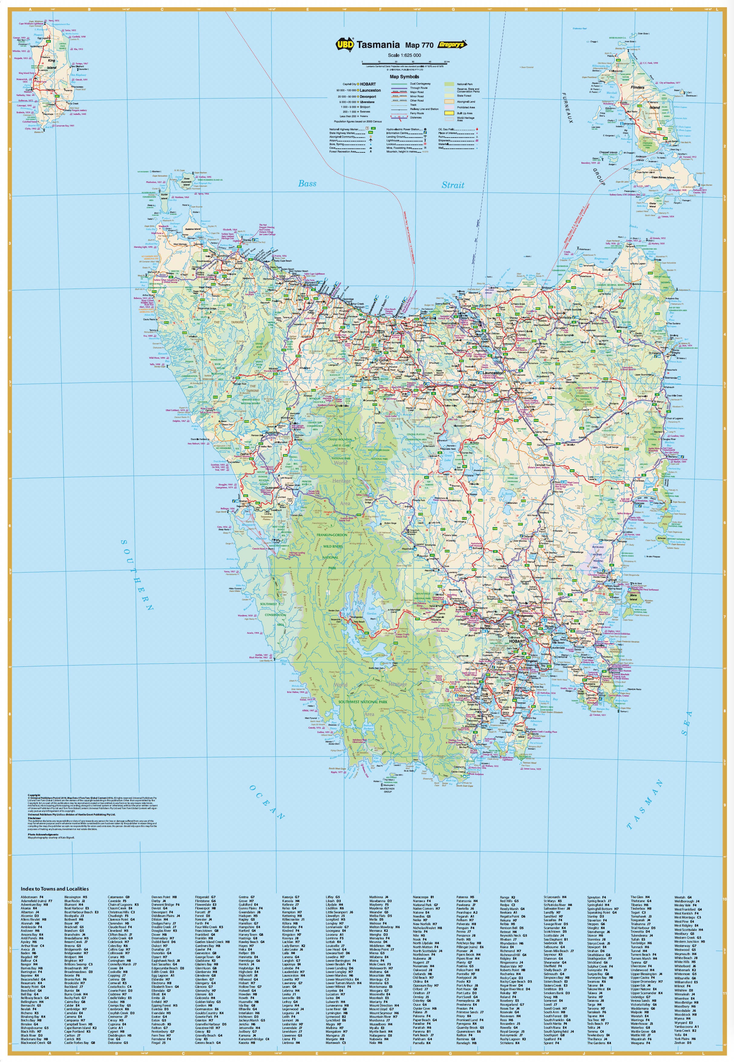
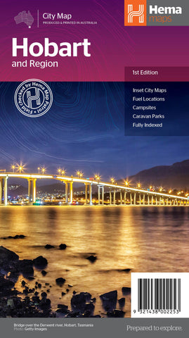
Tasmania State & Suburban Map 770 – UBD Gregory’s (29th Edition, 2023)
$13.95
Afterpay is only available for orders between $50.00 and $1000.00 More info
A comprehensive double-sided map of Tasmania, combining statewide coverage with detailed suburban mapping of Hobart – ideal for travel, planning, education, or display.
The UBD Gregory’s Tasmania State & Suburban Map 770 is a trusted, up-to-date reference tool for navigating both the rugged wilderness and the urban layout of Australia’s island state. Now in its 29th edition, this map provides two levels of mapping detail: a statewide overview and a suburban map of Hobart, making it perfect for travellers, educators, residents, and businesses alike.
With its large format, clear design, and practical extras—including indexed suburbs, road networks, and natural features—this is the go-to map for understanding Tasmania’s unique geography and infrastructure.
🗺️ Map Features
Side A – Tasmania State Map
Scale: 1:625,000
-
Covers the entire state of Tasmania, from King Island in the northwest to South East Cape
-
Clearly marked major and minor roads, highways, and ferry routes
-
Highlights towns, cities, national parks, state forests, and conservation areas
-
Includes localities and tourist routes
-
Indexed town and locality list for fast navigation
-
Labels major walking trails, scenic drives, regional attractions, and nature reserves
-
Features topographic relief shading to indicate elevation and terrain
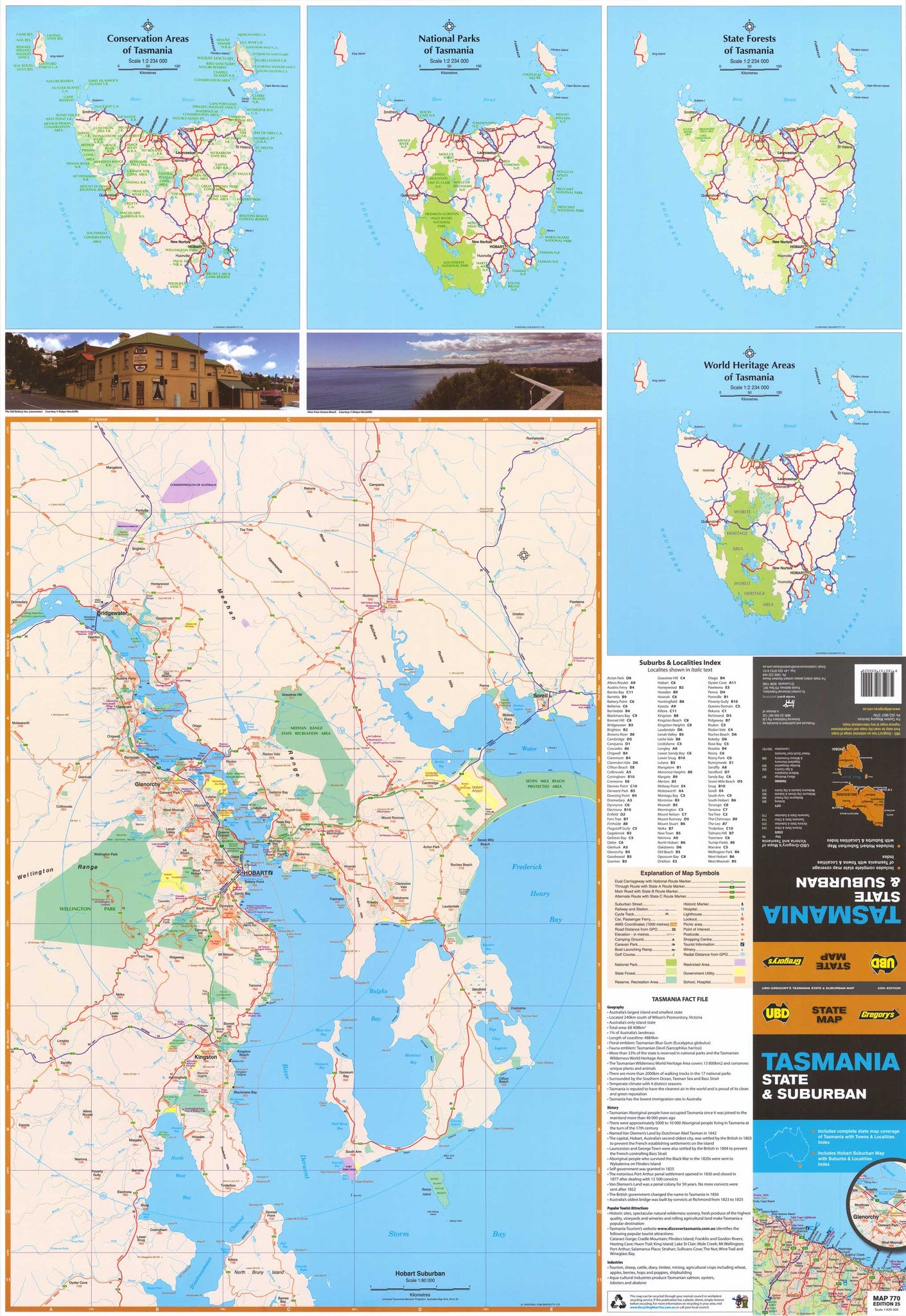
Side B – Greater Hobart Suburban Map
Scale: 1:80,000
-
Detailed mapping of Hobart and surrounding suburbs
-
Coverage extends:
-
North to Mangalore and Runnymede
-
South to Oyster Cove and South Arm
-
East to Sorell and Midway Point
-
West to Molesworth and Fern Tree
-
-
Includes:
-
Major roads, arterial routes, and local streets
-
Suburb names with postcode boundaries
-
Index of suburbs and localities for Hobart and surrounding districts
-
Location of parks, hospitals, shopping centres, and schools
-
National parks and nature reserves marked in green
-
🌿 Nature, Conservation & Travel Overlays
-
Shaded areas indicate Tasmania’s national parks, wilderness reserves, and World Heritage areas
-
Perfect for bushwalkers and nature lovers planning excursions to Cradle Mountain, Freycinet Peninsula, Mt Field, or the Southwest Wilderness
-
Identifies coastal access points and major tourism routes including the Great Eastern Drive and Heritage Highway
📐 Specifications
-
Edition: 29th
-
Published: 2023
-
Publisher: UBD Gregory’s (a division of Universal Publishers)
-
Flat Size: 1000 mm (W) × 690 mm (H)
-
Folded Size: Approx. 250 mm × 140 mm
-
Weight: ~85 grams
-
Print Format: Full colour, double-sided
-
Map Reference Code: UBD 770
🖨️ Available Formats
-
Folded Paper Map
-
Easy to carry and store
-
Ideal for on-the-road navigation or general use
-
-
Flat Laminated Map
-
Fully encapsulated in 80-micron gloss laminate
-
Durable and long-lasting
-
Great for wall mounting and classroom or office use
-
Write-on/wipe-off surface for planning trips or marking locations
-
Price: $99.00
-
-
Folded Laminated Map
-
Laminated version of the standard folded map
-
Slight crease lines visible but retains all the durability of lamination
-
Convenient and rugged enough for fieldwork
-
Price: $49.95
-
🎯 Perfect For
-
Travellers & road trippers exploring Tasmania’s towns, coastlines, and wild interiors
-
Local residents and real estate agents needing detailed suburb and postcode references
-
Government and infrastructure planners working across Hobart and regional areas
-
Schools and universities teaching geography, urban development, and ecology
-
Businesses and service providers planning logistics or coverage zones
-
Nature enthusiasts wanting to identify national parks, bushwalks, and reserves
🧭 Why Choose UBD Tasmania Map 770?
-
Published by UBD Gregory’s, Australia’s most trusted street mapping company
-
Features clear, accurate cartography designed for readability and real-world navigation
-
Regularly updated to reflect changing road networks, development zones, and local infrastructure
-
Combines statewide and suburban mapping in one practical resource
-
Available in durable laminated options perfect for professional or long-term use
Whether you’re navigating from Devonport to Hobart or planning a bushwalk in the highlands, the UBD Tasmania State & Suburban Map 770 is your complete visual reference to Tasmania’s roads, towns, and natural wonders—backed by the reliability of UBD Gregory’s mapping expertise.
Your essential Tasmanian map—ready to unfold, pin up, or take on the road.
Frequently Asked Questions
Where can I buy the Tasmania State & Suburban Map 770 – UBD Gregory’s (29th Edition, 2023)?
The Tasmania State & Suburban Map 770 – UBD Gregory’s (29th Edition, 2023) is available to buy online from Mapworld, Australia's largest map and geographic product retailer, with fast shipping Australia-wide.
Is the Tasmania State & Suburban Map 770 – UBD Gregory’s (29th Edition, 2023) in stock at Mapworld?
Mapworld maintains extensive stock across its map range and aims for fast dispatch. Orders placed before 2pm AEST on business days are typically dispatched the same day, with standard and express Australia-wide delivery options available.
What is Mapworld's returns policy?
Mapworld accepts returns on undamaged items in original condition. Contact Mapworld within 90 days of purchase to arrange a return or exchange.
Does Mapworld ship the Tasmania State & Suburban Map 770 – UBD Gregory’s (29th Edition, 2023) across Australia?
Yes, Mapworld ships Australia-wide. Standard shipping is a flat $7 rate, with free standard shipping on orders over $75. Express options are available at checkout. Most orders placed before 2pm AEST on weekdays are dispatched same day.
Related Items

© 2026 Mapworld. Website designed by Genie Media
X