- Australia ▾
- Topographic
▾
- Australia AUSTopo 250k (2025)
- Australia 50k Geoscience maps
- Australia 100k Geoscience maps
- Australia 250k Geoscience maps
- Australia 1:1m Geoscience maps
- New Zealand 50k maps
- New Zealand 250k maps
- New South Wales 25k maps
- New South Wales 50k maps
- New South Wales 100k maps
- Queensland 10k maps
- Queensland 25k maps
- Queensland 50k maps
- Queensland 100k maps
- Compasses
- Software
- GPS Systems
- Orienteering
- International ▾
- Wall Maps
▾
- World
- Australia & New Zealand
- Countries, Continents & Regions
- Historical
- Vintage National Geographic
- Australian Capital Territory
- New South Wales
- Northern Territory
- Queensland
- South Australia
- Tasmania
- Victoria
- Western Australia
- Celestial
- Children's
- Mining & Resources
- Wine Maps
- Healthcare
- Postcode Maps
- Electoral Maps
- Nautical ▾
- Flags
▾
- Australian Flag Sets & Banners
- Flag Bunting
- Handwavers
- Australian National Flags
- Aboriginal Flags
- Torres Strait Islander Flags
- International Flags
- Flagpoles & Accessories
- Australian Capital Territory Flags
- New South Wales Flags
- Northern Territory Flags
- Queensland Flags
- South Australia Flags
- Tasmania Flags
- Victoria Flags
- Western Australia Flags
- Gifts ▾
- Globes ▾
Dear valued customer. Please note that our checkout is not supported by old browsers. Please use a recent browser to access all checkout capabilities


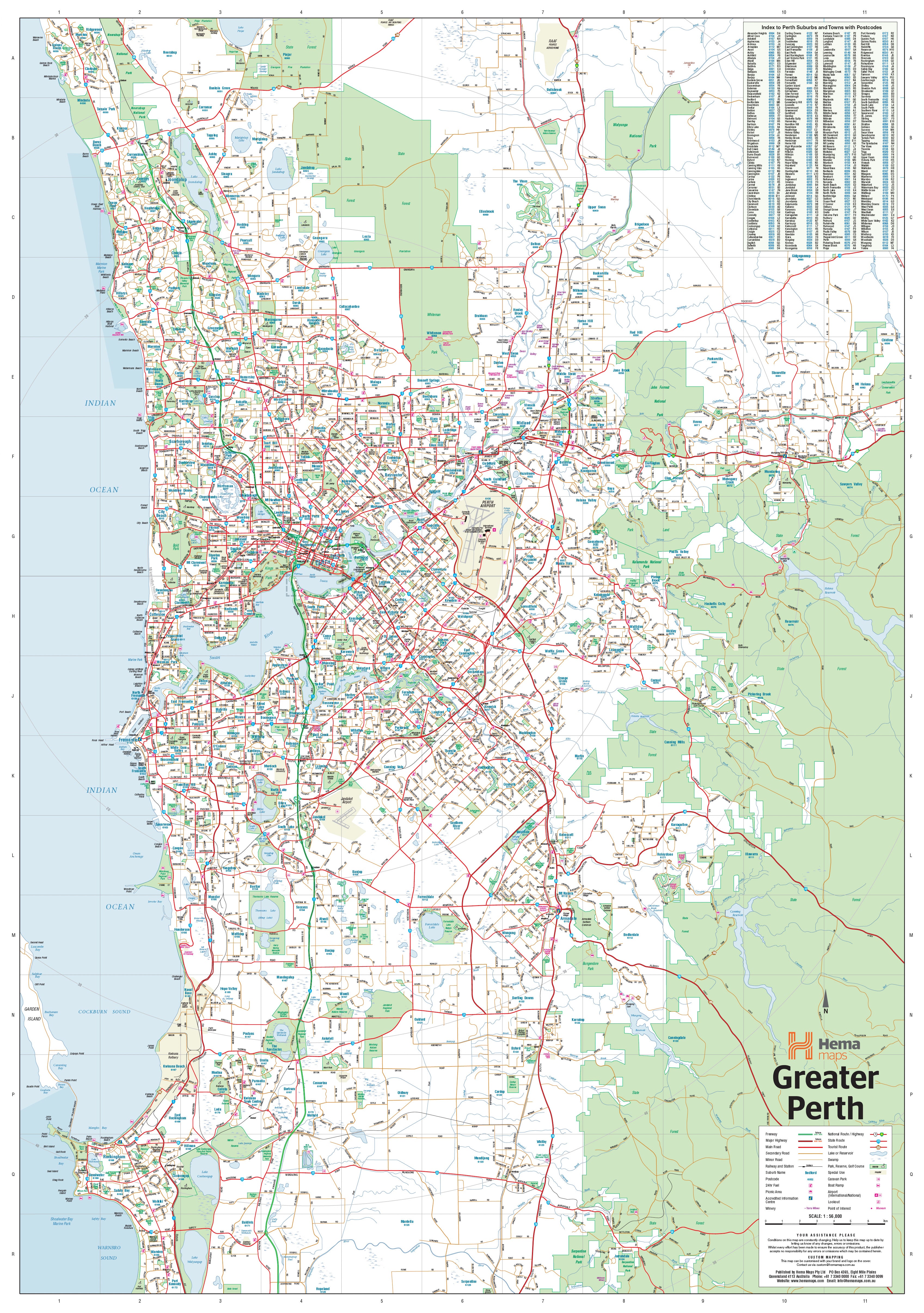

Perth & Region Hema 1400 x 2000mm Megamap Paper Wall Map
$299.95
or make 4 interest-free payments of
$74.99 AUD
fortnightly with
![]() More info
More info
Perth & Region — Hema Megamap (Paper Wall Map)
Size: 1400 mm (W) × 2000 mm (H)
Format: Megamap • Paper
Printed in Australia
The Perth & Region Hema Megamap is a commanding, large-format wall map designed to make Western Australia’s capital instantly understandable at a glance. Printed at an impressive 1400 × 2000 mm, this Megamap delivers exceptional clarity across Greater Perth, allowing suburbs, transport corridors, and regional connections to be read easily from across the room.
Covering the full Perth metropolitan area and surrounding regions, this map clearly shows major and secondary roads, state and national highways, and the structure of Perth’s expanding urban footprint. It’s ideal for offices, planning rooms, classrooms, operations spaces, and homes, where a big-picture understanding of Perth’s layout, growth corridors, and connections is essential.
Built on trusted Hema cartography, this Megamap balances detail and legibility, turning Perth’s sprawl into a clear, logical, and highly usable wall reference.
🗝️ Key Features
-
Comprehensive Perth & regional coverage — Metropolitan Perth and surrounding areas
-
Clear road hierarchy — Major & secondary roads shown with strong visual clarity
-
State & national highways — Easily trace long-distance and regional routes
-
Urban structure at scale — Understand suburbs, corridors, and connections at a glance
-
Megamap scale impact — Large-format design readable across shared spaces
-
Trusted Hema cartography — Renowned for accuracy, clarity, and clean design
🎨 Materials & Finish
-
Premium paper stock — Printed on high-quality matte paper, ideal for framing under glass
-
Low-glare surface — Matte finish reduces reflections in bright rooms
-
Fade-resistant printing — Pigment-based inks deliver crisp linework and stable colour
-
Megamap presentation — Designed to sit flat and remain readable for years
📐 Size & Orientation
-
1400 mm (w) × 2000 mm (h) (Megamap)
-
Orientation: Portrait
📊 Specifications
| Attribute | Details |
|---|---|
| Title | Perth & Region — Hema Megamap |
| Coverage | Perth metropolitan area & surrounding regions |
| Features | Major & secondary roads, state & national highways, suburbs and regional centres |
| Print Size | 1400 mm × 2000 mm |
| Format | FSC Paper (matte) |
| Inks | Pigment-based, fade-resistant |
| Origin | Printed in Australia |
🎯 Who it’s for
-
🏢 Businesses & offices — Metropolitan planning and regional overview
-
🚛 Transport & service operators — Understanding routes and coverage areas
-
🎓 Education & community spaces — Teaching Perth geography and urban growth
-
🏠 Homes & studios — A bold, informative Perth reference
-
🧭 Planning & operations rooms — Big-picture coordination and discussion
🤝 Our Commitment
Every Hema Megamap is printed locally in Australia using premium materials and fade-resistant inks. Each map is carefully checked and packed to ensure it arrives ready to deliver clarity, accuracy, and long-term usability.
🛒 Order your Perth & Region Hema Megamap today — a wall-filling, authoritative view of Greater Perth, designed for planning, learning, and seeing the city as a whole.
Frequently Asked Questions
What are the dimensions of the Perth & Region Hema 1400 x 2000mm Megamap Paper Wall Map?
Mapworld wall maps range from standard 700×1000mm to large-format 1000×1430mm Supermaps. The exact dimensions for this map are shown in the product title. Where multiple sizes are available, select your preferred size when adding to cart.
Is this wall map available laminated?
Many Mapworld wall maps are available in paper, laminated, or framed finishes. Check the product options when adding to cart. Laminated maps are wipe-clean and more durable.
Is this the latest edition?
Mapworld stocks the most current editions available from all publishers. Edition year is shown in the product title where applicable. Mapworld updates its catalogue as new editions are released.
Can I write on or pin this wall map?
Laminated wall maps can be written on with whiteboard markers and wiped clean. Paper maps can be pinned on a corkboard. Choose a laminated option for a writeable surface.
Does Mapworld ship the Perth & Region Hema 1400 x 2000mm Megamap Paper Wall Map across Australia?
Yes, Mapworld ships Australia-wide. Standard shipping is a flat $7 rate, with free standard shipping on orders over $75. Express options are available at checkout. Most orders placed before 2pm AEST on weekdays are dispatched same day.
Related Items
© 2026 Mapworld. Website designed by Genie Media
X