- Australia ▾
- Topographic
▾
- Australia AUSTopo 250k (2025)
- Australia 50k Geoscience maps
- Australia 100k Geoscience maps
- Australia 250k Geoscience maps
- Australia 1:1m Geoscience maps
- New Zealand 50k maps
- New Zealand 250k maps
- New South Wales 25k maps
- New South Wales 50k maps
- New South Wales 100k maps
- Queensland 10k maps
- Queensland 25k maps
- Queensland 50k maps
- Queensland 100k maps
- Western Australia 25k maps
- Western Australia 50k maps
- Western Australia 100k maps
- Compasses
- Software
- GPS Systems
- International ▾
- Wall Maps
▾
- World
- Australia & New Zealand
- Countries, Continents & Regions
- Historical
- Vintage National Geographic
- Australian Capital Territory
- New South Wales
- Northern Territory
- Queensland
- South Australia
- Tasmania
- Victoria
- Western Australia
- Celestial
- Children's
- Mining & Resources
- Wine Maps
- Healthcare
- Postcode Maps
- Electoral Maps
- Nautical ▾
- Flags
▾
- Australian Flag Sets & Banners
- Flag Bunting
- Handwavers
- Australian National Flags
- Aboriginal Flags
- Torres Strait Islander Flags
- International Flags
- Flagpoles & Accessories
- Australian Capital Territory Flags
- New South Wales Flags
- Northern Territory Flags
- Queensland Flags
- South Australia Flags
- Tasmania Flags
- Victoria Flags
- Western Australia Flags
- Gifts ▾
- Globes ▾
Dear valued customer. Please note that our checkout is not supported by old browsers. Please use a recent browser to access all checkout capabilities


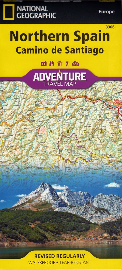
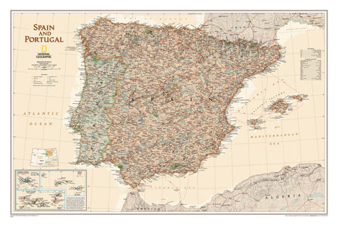
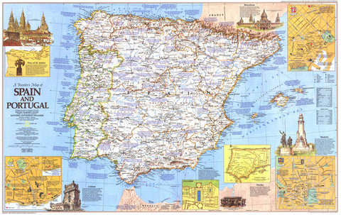
Northern Spain - Camino de Santiago - Way of St James National Geographic Folded Map
$27.95
Afterpay is only available for orders between $50.00 and $1000.00 More info
Featuring the Camino de Santiago / Way of St James Pilgrimage Routes
Scale: 1:375,000 | Folded Size: 235 x 108 mm | Unfolded Size: 965 x 660 mm
Format: Double-sided | Printed on waterproof, tear-resistant synthetic paper
🚶 Walk the Pilgrimage. Discover the Soul of Spain.
National Geographic’s Northern Spain Adventure Map is the ultimate companion for anyone exploring this diverse and culturally rich region — and an essential guide for modern pilgrims walking the Camino de Santiago, or Way of St James.
Whether you're setting out on foot, by bicycle, or by car, this beautifully rendered map captures the geography, road networks, and pilgrimage routes that crisscross the green northern expanse of Spain, from the Pyrenees to the Atlantic.
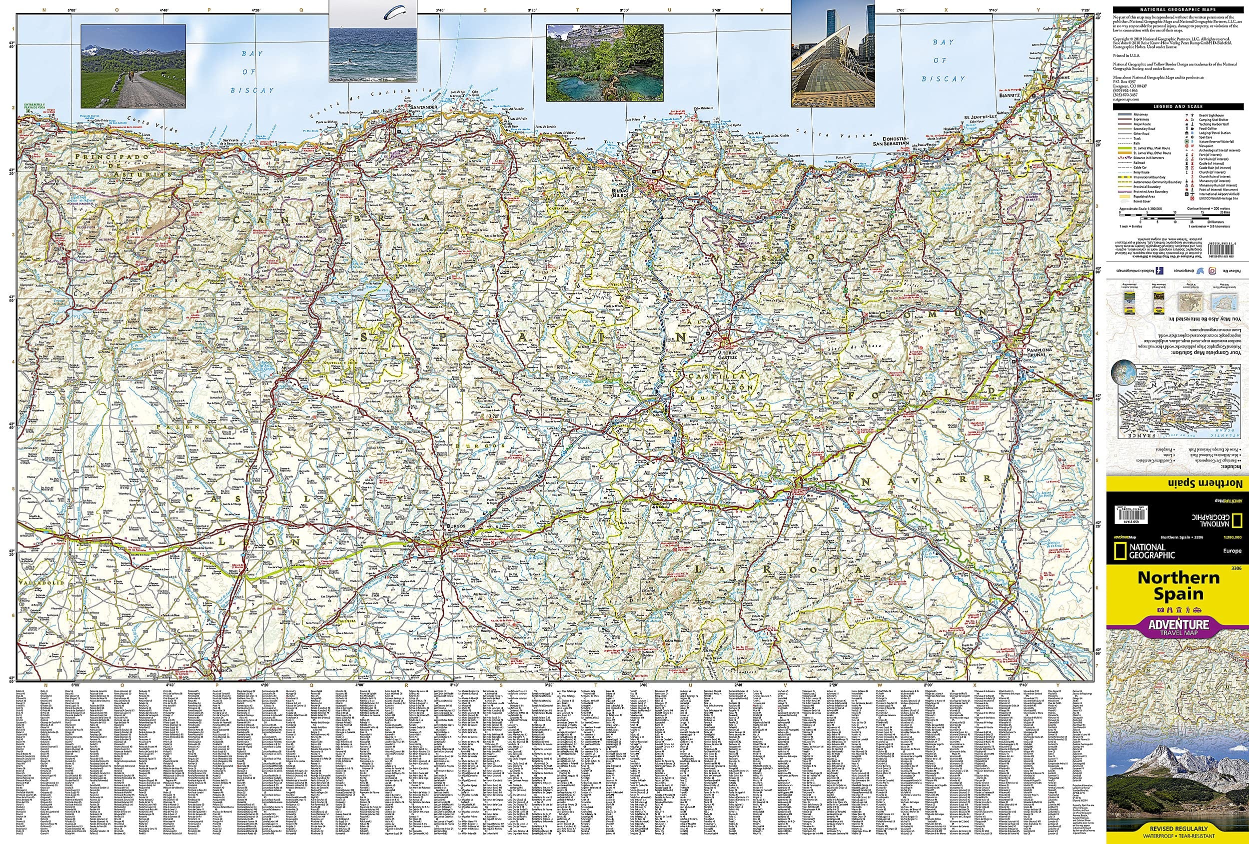
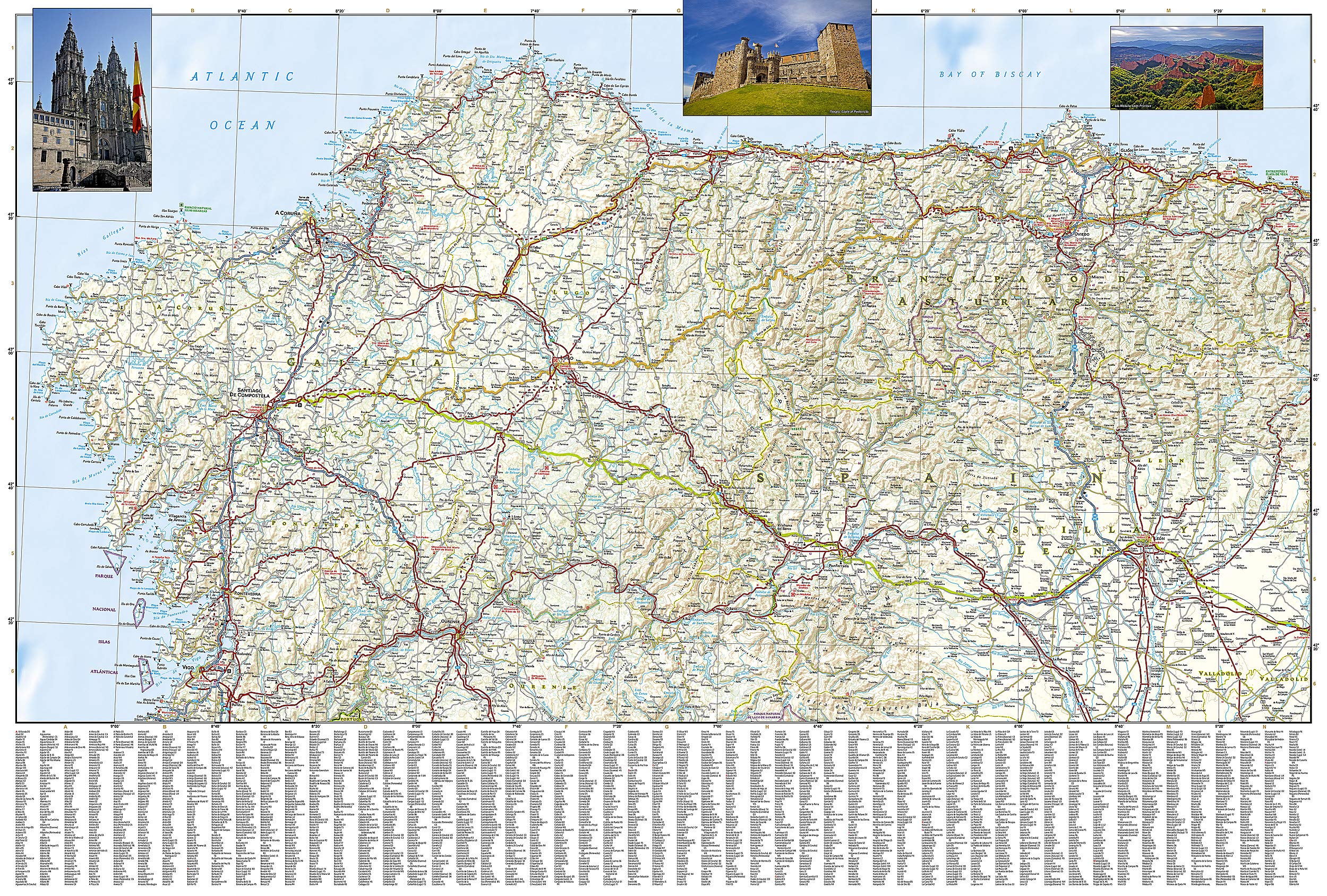
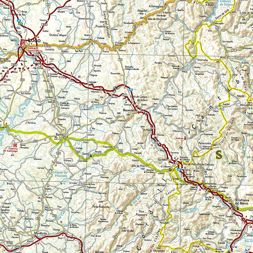
🗺️ Map Coverage & Features
| Section | Details |
|---|---|
| 🧭 Main Coverage | Northern Spain, including the Camino de Santiago pilgrimage network |
| 🚶♂️ Camino Routes | Shows the main route via Pamplona, Burgos & León, as well as alternative routes from Bayonne to Villaviciosa and onward to Santiago de Compostela |
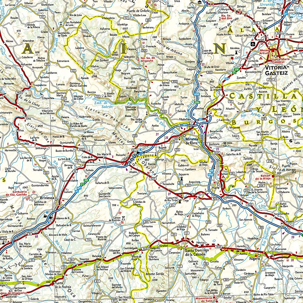
| 🏞️ Front Side | Eastern Northern Spain from the French border to Tudela in the south and west to Cangas de Onís and Palencia |
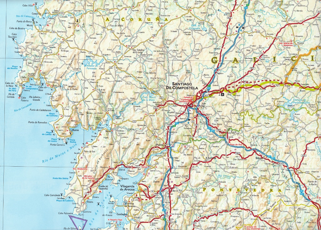
| 🌊 Reverse Side | Western half of the region, from Cangas de Onís and León to the Atlantic coast, including Galicia and Santiago de Compostela |
| 🛣️ Road Networks | Clearly marked highways, secondary roads, scenic routes, and trails — all with distance indicators |
| 🏙️ Towns & Cities | Hundreds of towns, villages, and cities with an easy-to-use index |
| 📍 Points of Interest | Includes natural parks, UNESCO World Heritage sites, historical landmarks, churches, and monasteries |
🌍 Adventure-Ready Materials
-
✅ Printed on synthetic waterproof paper – durable, flexible, and tear-resistant
-
✅ Two-sided folding design for efficient use of space and easy referencing on the trail
-
✅ Packable size – folds down to a compact 235 x 108 mm for backpacks, guidebook sleeves, or jacket pockets
-
✅ Built for the rigours of long-distance walking, cycling, or driving
🎯 Who This Map Is For
-
🚶♀️ Pilgrims walking the Camino de Santiago, including the French, Northern, and Primitive Routes
-
🧭 Adventure travellers exploring the mountains, coastlines, and countryside of northern Spain
-
🚗 Road-trippers navigating from the Pyrenees to Galicia
-
📚 Cultural and heritage travellers tracing the footsteps of history, faith, and tradition
-
🎒 Outdoor enthusiasts hiking or biking remote sections of Spain’s most iconic trails
📘 Product Summary
| Specification | Details |
|---|---|
| Publisher | National Geographic Maps |
| Title | Northern Spain – Camino de Santiago Adventure Map |
| Map Type | Double-sided folded map |
| Scale | 1:375,000 |
| Unfolded Size | 965 mm x 660 mm |
| Folded Size | 235 mm x 108 mm |
| Material | Waterproof, tear-resistant synthetic paper |
| Language | Multilingual legend including English, Spanish, French, and German |
✨ Walk with Purpose. Travel with Insight.
This map is more than a navigation tool — it’s an invitation. To tread the ancient roads of the Camino. To feel the wind in the Basque hills. To watch the sun rise over Galicia. And to arrive in Santiago not just having found a destination, but having discovered a deeper connection with the land and its stories.
🗝️ Begin your journey today with the most trusted map in your pack — National Geographic.
Frequently Asked Questions
What area does the Northern Spain - Camino de Santiago - Way of St James National Geograp cover?
The Northern Spain - Camino de Santiago - Way of St James National Geograp provides road coverage of the region named in the product title. The map covers major cities, highways, towns, and regional roads, with inset city maps for key urban centres where applicable.
Is the Northern Spain - Camino de Santiago - Way of St James National Geograp up to date?
Yes, this is the current edition. Mapworld stocks the most current editions from all major publishers, updated to reflect new roads and infrastructure.
What size is this map when unfolded?
Folded maps from Mapworld's range are compact and portable. Most standard folded road or travel maps open to between A1 (594 × 841mm) and A0 (841 × 1189mm) when fully unfolded, and fold down to approximately A4 or smaller for easy storage in a glove box, bag, or backpack.
Is the Northern Spain - Camino de Santiago - Way of St James National Geograp in stock at Mapworld?
Mapworld maintains extensive stock across its map range and aims for fast dispatch. Orders placed before 2pm AEST on business days are typically dispatched the same day, with standard and express Australia-wide delivery options available.
Does Mapworld ship the Northern Spain - Camino de Santiago - Way of St James National Geograp across Australia?
Yes, Mapworld ships Australia-wide. Standard shipping is a flat $7 rate, with free standard shipping on orders over $75. Express options are available at checkout. Most orders placed before 2pm AEST on weekdays are dispatched same day.
Related Items
© 2026 Mapworld. Website designed by Genie Media
X