- Australia ▾
- Topographic
▾
- Australia AUSTopo 250k (2025)
- Australia 50k Geoscience maps
- Australia 100k Geoscience maps
- Australia 250k Geoscience maps
- Australia 1:1m Geoscience maps
- New Zealand 50k maps
- New Zealand 250k maps
- New South Wales 25k maps
- New South Wales 50k maps
- New South Wales 100k maps
- Queensland 10k maps
- Queensland 25k maps
- Queensland 50k maps
- Queensland 100k maps
- Western Australia 25k maps
- Western Australia 50k maps
- Western Australia 100k maps
- Compasses
- Software
- GPS Systems
- International ▾
- Wall Maps
▾
- World
- Australia & New Zealand
- Countries, Continents & Regions
- Historical
- Vintage National Geographic
- Australian Capital Territory
- New South Wales
- Northern Territory
- Queensland
- South Australia
- Tasmania
- Victoria
- Western Australia
- Celestial
- Children's
- Mining & Resources
- Wine Maps
- Healthcare
- Postcode Maps
- Electoral Maps
- Nautical ▾
- Flags
▾
- Australian Flag Sets & Banners
- Flag Bunting
- Handwavers
- Australian National Flags
- Aboriginal Flags
- Torres Strait Islander Flags
- International Flags
- Flagpoles & Accessories
- Australian Capital Territory Flags
- New South Wales Flags
- Northern Territory Flags
- Queensland Flags
- South Australia Flags
- Tasmania Flags
- Victoria Flags
- Western Australia Flags
- Gifts ▾
- Globes ▾
Dear valued customer. Please note that our checkout is not supported by old browsers. Please use a recent browser to access all checkout capabilities


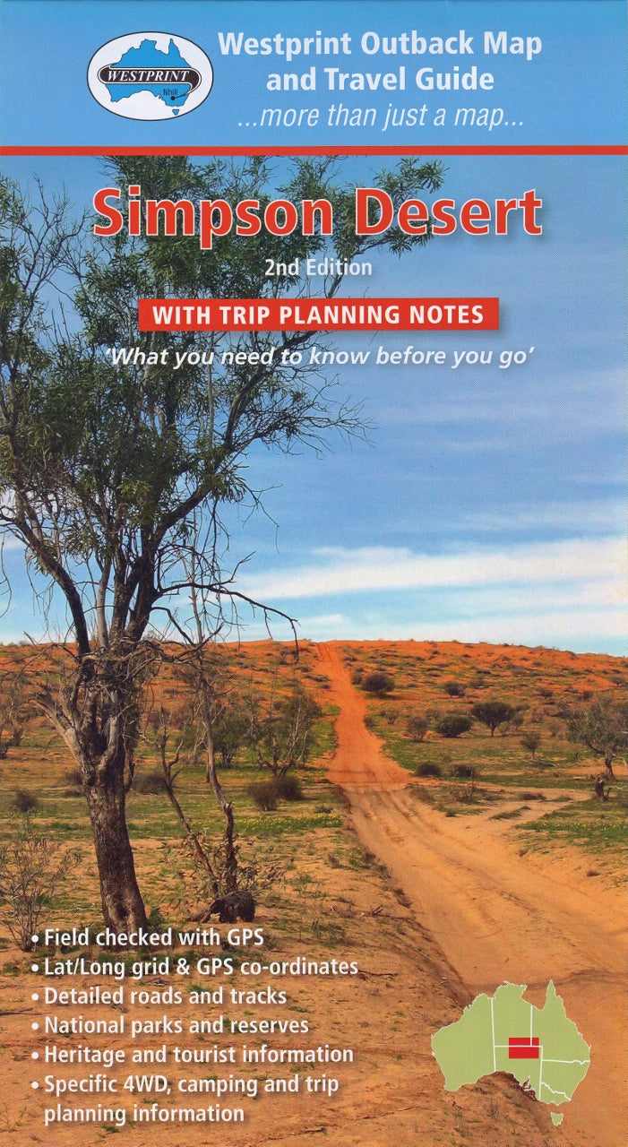
Simpson Desert Map Westprint
$14.95 $15.95
Afterpay is only available for orders between $50.00 and $1000.00 More info
🏜️ Simpson Desert Map – Westprint Heritage Series
The definitive map and trip-planning tool for navigating Australia’s most iconic desert crossing
🔍 Overview
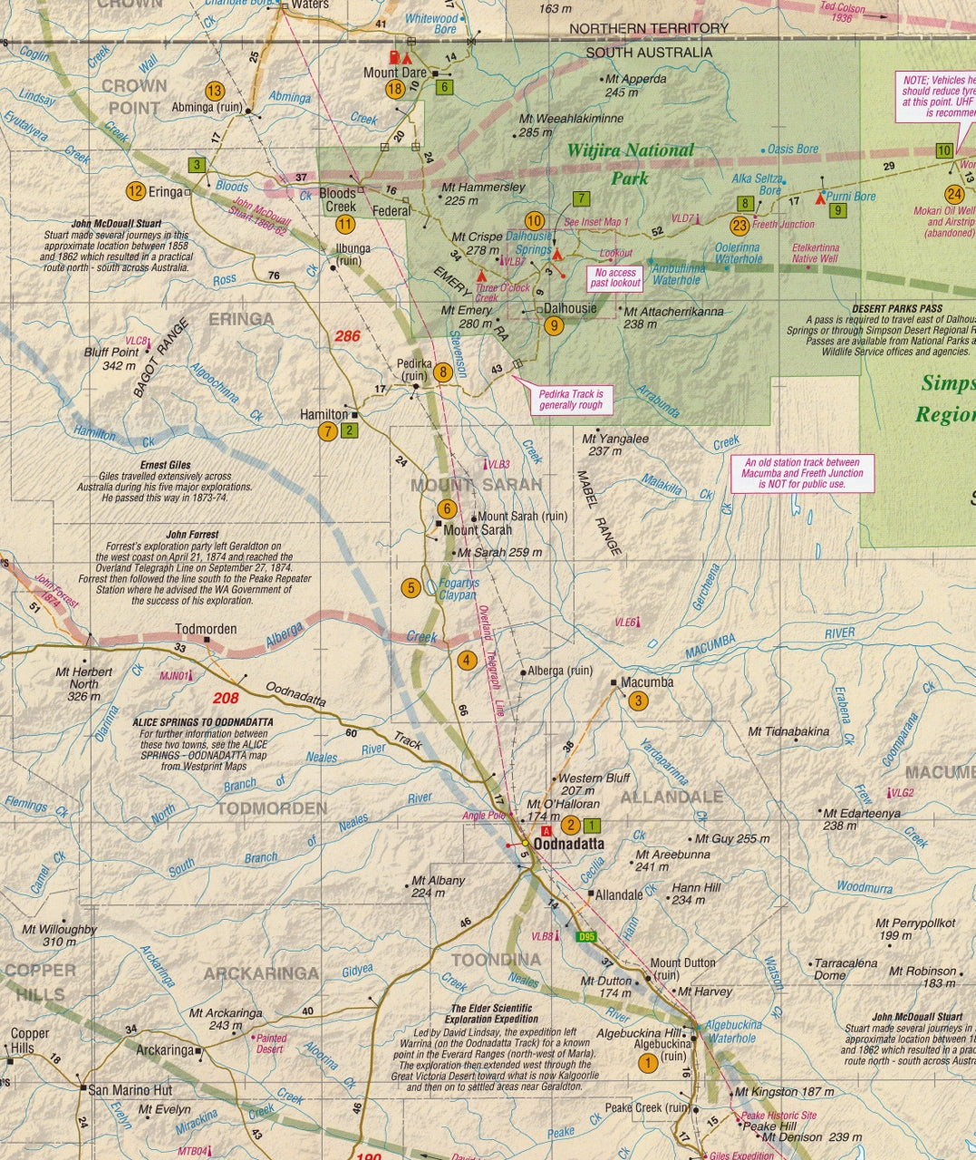
The Simpson Desert Map by Westprint is a purpose-built, richly detailed resource designed to help adventurers plan, navigate, and explore one of the most remote and awe-inspiring environments in the world — the Simpson Desert. Known for its towering red sand dunes, salt pans, and isolated beauty, the Simpson is a challenge even for experienced 4WD enthusiasts. This map provides the precision, context, and insights you need to travel safely and confidently through this spectacular region.
Whether you're preparing for a full desert crossing via the French Line, camping at Dalhousie Springs, or seeking out historic sites like Poeppel Corner, this two-sided map delivers both detailed topographic coverage and essential travel intelligence.
🗺️ Map Format & Features
Dual-Sided Design for Maximum Utility
Side A – Full Colour Topographic Map
-
Scale: 1:1,000,000 – ideal for wide-ranging route planning
-
Lat/Long Grid & GPS Coordinates throughout
-
Coverage includes:
-
French Line, Rig Road, WAA Line
-
Knolls Track, QAA Line, Hay River Track
-
Purni Bore, Dalhousie Springs, Poeppel Corner
-
Eyre Creek, Mt Dare, Birdsville
-
-
Marked fuel points, campgrounds, natural landmarks, and historic features
-
All major and minor 4WD tracks with intermediate distances clearly marked
-
Elevation shading and dune markings to help assess terrain and difficulty
Side B – Planning Guide & Track Notes
-
Detailed notes on over 60 points of interest, indexed to the map
-
Historical notes on early exploration, especially Burke & Wills and European surveying
-
Track classifications, suggested routes, and insider driving tips
-
Information on:
-
Vehicle prep
-
Fuel and water requirements
-
Safety and emergency guidelines
-
Weather and seasonal access
-
Camping etiquette and Leave No Trace principles
-
🧭 Coverage Highlights
| Region / Feature | Included? |
|---|---|
| Dalhousie Springs | ✅ |
| French Line | ✅ |
| QAA Line & Eyre Creek | ✅ |
| WAA Line & Rig Road | ✅ |
| Knolls Track | ✅ |
| Hay River Track (northern extension) | ✅ |
| Purni Bore | ✅ |
| Poeppel Corner | ✅ |
| Mt Dare, Birdsville, Oodnadatta Access Routes | ✅ |
🛠️ Practical Tools for Travellers
-
✅ GPS-ready – Ideal for use with satellite navigation devices
-
✅ Permit guidance – Clearly explains SA Desert Parks Pass requirements
-
✅ Emergency prep – Includes contacts, roadhouses, ranger stations
-
✅ Camping info – Official and bush campsites shown
-
✅ Fuel planning – Petrol & diesel availability, distances between refuels
-
✅ Trip advice – Tyre pressure, sand-driving techniques, and more
📏 Product Specifications
| Attribute | Detail |
|---|---|
| Map Title | Simpson Desert Trip Planning Map |
| Publisher | Westprint |
| Edition | Latest Revised Edition |
| Scale | 1:1,000,000 |
| Format | Folded paper map (single sheet, double-sided) |
| Flat Size | 1000 mm (W) x 700 mm (H) |
| Folded Size | Approx. 140 mm x 250 mm |
| Material | Heavy-duty paper or optional 80-micron gloss laminated version |
| Weight | Approx. 60 g |
| ISBN | 9781875608232 |
| Printed in | Australia |
💡 Note on Permits
A South Australia Desert Parks Pass is required to drive across the Simpson Desert and camp in conservation areas such as:
-
Witjira National Park
-
Simpson Desert Conservation Park
-
Simpson Desert Regional Reserve
Day-use permits for Dalhousie Springs only may be available on-site, subject to access and weather conditions.
Pro Tip: Apply for your permit online in advance, and carry both printed and digital copies.
🎯 Who Is This Map For?
-
🛻 4WD tourers crossing from Mt Dare to Birdsville
-
⛺ Bush campers setting up in remote desert sites
-
🧭 Overland travellers combining Simpson tracks with Oodnadatta or Hay River routes
-
🌵 Desert naturalists interested in flora, fauna, and conservation
-
📷 Photographers and explorers documenting Australia’s Red Centre
-
🧳 Tour operators guiding desert safaris or self-drive holidays
-
🧰 Outback prepper kits and emergency travel boxes
🧭 Why Choose a Westprint Map?
✅ Trusted Australian publisher specialising in heritage and outback maps
✅ Content-rich — more than just roads: learn about explorers, history, and Indigenous culture
✅ Field-tested accuracy — no armchair mapping here!
✅ Printed in Australia using high-quality stock
✅ Optional lamination makes it practically indestructible and suitable for whiteboard markers
🌄 Explore Australia’s Legendary Red Centre with Confidence
From Dalhousie’s thermal springs to the endless dunes of the French Line, every kilometre of the Simpson Desert presents a new challenge — and a new reward. The Westprint Simpson Desert Map is your trusted companion, helping you chart a course, learn the stories of the land, and return home safely.
🧭 Plan your desert crossing the right way – with Westprint by your side.
Frequently Asked Questions
Where can I buy the Simpson Desert Map Westprint?
The Simpson Desert Map Westprint is available to buy online from Mapworld, Australia's largest map and geographic product retailer, with fast shipping Australia-wide.
Is the Simpson Desert Map Westprint in stock at Mapworld?
Mapworld maintains extensive stock across its map range and aims for fast dispatch. Orders placed before 2pm AEST on business days are typically dispatched the same day, with standard and express Australia-wide delivery options available.
What is Mapworld's returns policy?
Mapworld accepts returns on undamaged items in original condition. Contact Mapworld within 90 days of purchase to arrange a return or exchange.
Does Mapworld ship the Simpson Desert Map Westprint across Australia?
Yes, Mapworld ships Australia-wide. Standard shipping is a flat $7 rate, with free standard shipping on orders over $75. Express options are available at checkout. Most orders placed before 2pm AEST on weekdays are dispatched same day.
Related Items

© 2026 Mapworld. Website designed by Genie Media
X