- Australia ▾
- Topographic
▾
- Australia AUSTopo 250k (2025)
- Australia 50k Geoscience maps
- Australia 100k Geoscience maps
- Australia 250k Geoscience maps
- Australia 1:1m Geoscience maps
- New Zealand 50k maps
- New Zealand 250k maps
- New South Wales 25k maps
- New South Wales 50k maps
- New South Wales 100k maps
- Queensland 10k maps
- Queensland 25k maps
- Queensland 50k maps
- Queensland 100k maps
- Western Australia 25k maps
- Western Australia 50k maps
- Western Australia 100k maps
- Compasses
- Software
- GPS Systems
- International ▾
- Wall Maps
▾
- World
- Australia & New Zealand
- Countries, Continents & Regions
- Historical
- Vintage National Geographic
- Australian Capital Territory
- New South Wales
- Northern Territory
- Queensland
- South Australia
- Tasmania
- Victoria
- Western Australia
- Celestial
- Children's
- Mining & Resources
- Wine Maps
- Healthcare
- Postcode Maps
- Electoral Maps
- Nautical ▾
- Flags
▾
- Australian Flag Sets & Banners
- Flag Bunting
- Handwavers
- Australian National Flags
- Aboriginal Flags
- Torres Strait Islander Flags
- International Flags
- Flagpoles & Accessories
- Australian Capital Territory Flags
- New South Wales Flags
- Northern Territory Flags
- Queensland Flags
- South Australia Flags
- Tasmania Flags
- Victoria Flags
- Western Australia Flags
- Gifts ▾
- Globes ▾
Dear valued customer. Please note that our checkout is not supported by old browsers. Please use a recent browser to access all checkout capabilities


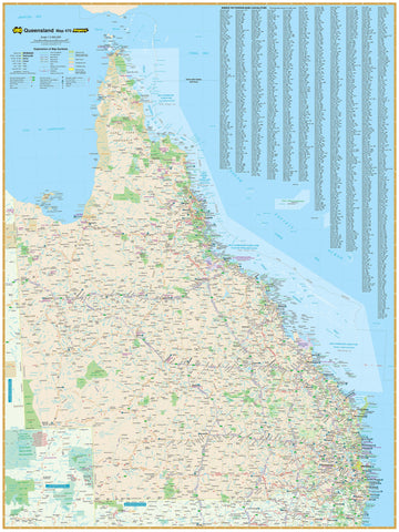
Carnarvon National Park Queensland Geoscience Map
$29.95 $34.95
Afterpay is only available for orders between $50.00 and $1000.00 More info
Queensland | Detailed Terrain & Landscape Features | Scale 1:250,000
Discover one of Queensland’s most iconic natural landscapes with the Carnarvon National Park Topographic Map by Geoscience Australia. Produced at a detailed scale of 1:250,000, this specialised map offers an in-depth overview of the park’s vast sandstone ranges, dramatic escarpments, winding gorges, and surrounding terrain.
Whether you’re an avid hiker, outdoor educator, geologist, or cartography enthusiast, this map provides precise topographic information to support exploration, environmental study, and trip planning.
🗺️ Map Features
| Feature | Description |
|---|---|
| 📏 Scale | 1:250,000 – ideal for regional overview and large-area navigation |
| 🗺️ Topographic Detail | Contour lines, elevation data, drainage networks, and terrain types |
| 🌄 Park Overview | Covers Carnarvon National Park and surrounding regions in Queensland |
| 📍 Natural Features | Rivers, cliffs, escarpments, access tracks, and key geographic landmarks |
| 📐 Official Government Map | Published by Geoscience Australia, trusted for scientific accuracy |
📐 Product Specifications
| Specification | Detail |
|---|---|
| Title | Carnarvon National Park Topographic Map |
| Publisher | Geoscience Australia |
| Coverage Area | Carnarvon National Park, Central Queensland |
| Scale | 1:250,000 |
| Format | Folded map |
| Full colour with terrain shading and contours |
🎯 Ideal For:
-
🥾 Bushwalkers & adventurers exploring the remote tracks and scenic ridges
-
🧭 Topographic map readers needing detailed terrain and navigation information
-
🧑🏫 Educators & students studying Queensland geography or landforms
-
🪨 Geologists & researchers referencing landscape and rock formations
-
📍 Visitors to Carnarvon Gorge & surrounds looking for a broad regional view
🛒 Plan Your Journey into Queensland’s Sandstone Country
From towering cliffs to ancient Aboriginal rock art sites, Carnarvon National Park is a breathtaking window into Australia’s natural history. Equip yourself with the Geoscience Australia Topographic Map and experience the region with clarity, confidence, and perspective.
📦 Add to cart now. For field durability, contact us about optional lamination.
Frequently Asked Questions
Where can I buy the Carnarvon National Park Queensland Geoscience Map?
The Carnarvon National Park Queensland Geoscience Map is available to buy online from Mapworld, Australia's largest map and geographic product retailer, with fast shipping Australia-wide.
Is the Carnarvon National Park Queensland Geoscience Map in stock at Mapworld?
Mapworld maintains extensive stock across its map range and aims for fast dispatch. Orders placed before 2pm AEST on business days are typically dispatched the same day, with standard and express Australia-wide delivery options available.
What is Mapworld's returns policy?
Mapworld accepts returns on undamaged items in original condition. Contact Mapworld within 90 days of purchase to arrange a return or exchange.
Does Mapworld ship the Carnarvon National Park Queensland Geoscience Map across Australia?
Yes, Mapworld ships Australia-wide. Standard shipping is a flat $7 rate, with free standard shipping on orders over $75. Express options are available at checkout. Most orders placed before 2pm AEST on weekdays are dispatched same day.
Related Items

© 2026 Mapworld. Website designed by Genie Media
X