- Australia ▾
- Topographic
▾
- Australia AUSTopo 250k (2025)
- Australia 50k Geoscience maps
- Australia 100k Geoscience maps
- Australia 250k Geoscience maps
- Australia 1:1m Geoscience maps
- New Zealand 50k maps
- New Zealand 250k maps
- New South Wales 25k maps
- New South Wales 50k maps
- New South Wales 100k maps
- Queensland 10k maps
- Queensland 25k maps
- Queensland 50k maps
- Queensland 100k maps
- Compasses
- Software
- GPS Systems
- Orienteering
- International ▾
- Wall Maps
▾
- World
- Australia & New Zealand
- Countries, Continents & Regions
- Historical
- Vintage National Geographic
- Australian Capital Territory
- New South Wales
- Northern Territory
- Queensland
- South Australia
- Tasmania
- Victoria
- Western Australia
- Celestial
- Children's
- Mining & Resources
- Wine Maps
- Healthcare
- Postcode Maps
- Electoral Maps
- Nautical ▾
- Flags
▾
- Australian Flag Sets & Banners
- Flag Bunting
- Handwavers
- Australian National Flags
- Aboriginal Flags
- Torres Strait Islander Flags
- International Flags
- Flagpoles & Accessories
- Australian Capital Territory Flags
- New South Wales Flags
- Northern Territory Flags
- Queensland Flags
- South Australia Flags
- Tasmania Flags
- Victoria Flags
- Western Australia Flags
- Gifts ▾
- Globes ▾
Dear valued customer. Please note that our checkout is not supported by old browsers. Please use a recent browser to access all checkout capabilities
Queensland Hema 700 x 1000mm State Laminated Wall Map
$99.95
or make 4 interest-free payments of
$24.99 AUD
fortnightly with
![]() More info
More info
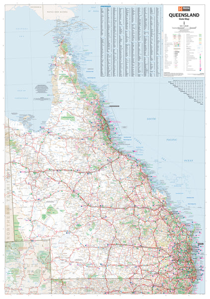
An exceptionally detailed and professionally finished state map of Queensland — ideal for planning, presentation, and display.
The Queensland State Map by Hema Maps is one of the most accurate and visually clear maps available for this vast and geographically diverse region. Covering everything from tropical Cape York to the Outback west, the Great Dividing Range, and the densely populated coastal strip, this map provides a true sense of Queensland’s scale, connectivity, and topography.
Whether you're managing a transport route, marking project areas, planning a road trip, or educating a classroom, this wall map is a dependable and informative reference that combines practical functionality with beautiful cartographic design.
🗺️ Coverage & Cartographic Detail
Designed by Hema’s trusted cartographers, the map shows:
-
Complete state-wide coverage, including remote regions, rural townships, and major population centres
-
All national highways, state and regional roads, and minor routes, with clear classification between sealed and unsealed roads
-
Clearly marked cities and towns, rail lines, state boundaries, airports, and port infrastructure
-
Detailed depiction of natural features, including:
-
Rivers and water bodies
-
National parks, reserves, and Indigenous protected areas
-
Elevation shading and topographical relief
-
-
Inset legends and clear labelling for easy readability from a distance
This is a state map designed for clarity, readability, and accuracy — ideal for professionals, educators, and travellers alike.
🖨️ Print & Laminate Quality
Printed using fade-resistant pigment-based inks from Hewlett-Packard, the Queensland State Map is produced to archival standards, ensuring vibrant colour and long-lasting detail.
-
Printed on 120 gsm FSC-certified matte-coated paper
-
Fully laminated between two 80-micron gloss sheets, making it:
-
Durable and resistant to wear and tear
-
Wipeable — use dry-erase markers for annotations
-
Ideal for repeated handling in office or classroom environments
-
-
Use with Mark-It-Dots (available separately) to highlight key locations without damaging the map
🌧️ Waterproof & Tearproof Tyvek Version (Optional)
For high-demand environments or outdoor use, this map is also available on synthetic Tyvek material, making it:
-
Completely waterproof and tearproof
-
Flexible, lightweight, and almost indestructible
-
Perfect for fieldwork, field stations, survey teams, and emergency services operating across the state
This version is particularly useful for resource management, infrastructure work, or remote area navigation where standard laminated maps may not withstand conditions.
📐 Specifications
-
Scale: 1:2,500,000 (1 cm ≈ 25 km)
-
Size: 700 mm (W) × 1000 mm (H)
-
Orientation: Portrait
-
Edition: Latest available from Hema Maps
-
Publisher: Hema Maps
-
Printed in: Australia
🛒 Purchase Options
-
Flat Laminated Map – $99.00
-
Supplied flat for immediate wall mounting or framing
-
Recommended for boardrooms, offices, schools, and professional settings
-
-
Tyvek Waterproof Version – $79.95
-
Ideal for field professionals and outdoor workspaces
-
Lightweight, foldable, and extremely durable
-
Optional: Add wooden hang rails for an elegant, ready-to-hang finish (please allow up to 10 business days for framing and dispatch).
🎯 Who This Map is For
-
Transport and logistics managers mapping out operational routes
-
Urban planners and regional development teams
-
Government departments and emergency response units
-
Travel agencies, tour operators, and tourism centres
-
Schools, TAFEs, and universities for geography and planning education
-
Home offices, caravanners, and road trip planners
-
Resource exploration, mining, and land management teams
✅ Why Choose the Hema Queensland State Wall Map?
-
Trusted accuracy from Australia’s leading map publisher
-
High-quality print and lamination for long-term usability
-
Easy to read from a distance — perfect for wall use
-
Fully Australian-made using local data, materials, and design
-
A combination of functional precision and presentation-quality aesthetics
From remote cattle stations to the tropical coast, the Queensland Hema State Map brings the entire state into focus.
Plan smarter, travel further, and manage operations more effectively — all with the reliability of Hema at your side.
Your wall, your work, your Queensland — mapped to perfection.


