- Australia ▾
- Topographic
▾
- Australia AUSTopo 250k (2025)
- Australia 50k Geoscience maps
- Australia 100k Geoscience maps
- Australia 250k Geoscience maps
- Australia 1:1m Geoscience maps
- New Zealand 50k maps
- New Zealand 250k maps
- New South Wales 25k maps
- New South Wales 50k maps
- New South Wales 100k maps
- Queensland 10k maps
- Queensland 25k maps
- Queensland 50k maps
- Queensland 100k maps
- Western Australia 25k maps
- Western Australia 50k maps
- Western Australia 100k maps
- Compasses
- Software
- GPS Systems
- International ▾
- Wall Maps
▾
- World
- Australia & New Zealand
- Countries, Continents & Regions
- Historical
- Vintage National Geographic
- Australian Capital Territory
- New South Wales
- Northern Territory
- Queensland
- South Australia
- Tasmania
- Victoria
- Western Australia
- Celestial
- Children's
- Mining & Resources
- Wine Maps
- Healthcare
- Postcode Maps
- Electoral Maps
- Nautical ▾
- Flags
▾
- Australian Flag Sets & Banners
- Flag Bunting
- Handwavers
- Australian National Flags
- Aboriginal Flags
- Torres Strait Islander Flags
- International Flags
- Flagpoles & Accessories
- Australian Capital Territory Flags
- New South Wales Flags
- Northern Territory Flags
- Queensland Flags
- South Australia Flags
- Tasmania Flags
- Victoria Flags
- Western Australia Flags
- Gifts ▾
- Globes ▾
Dear valued customer. Please note that our checkout is not supported by old browsers. Please use a recent browser to access all checkout capabilities


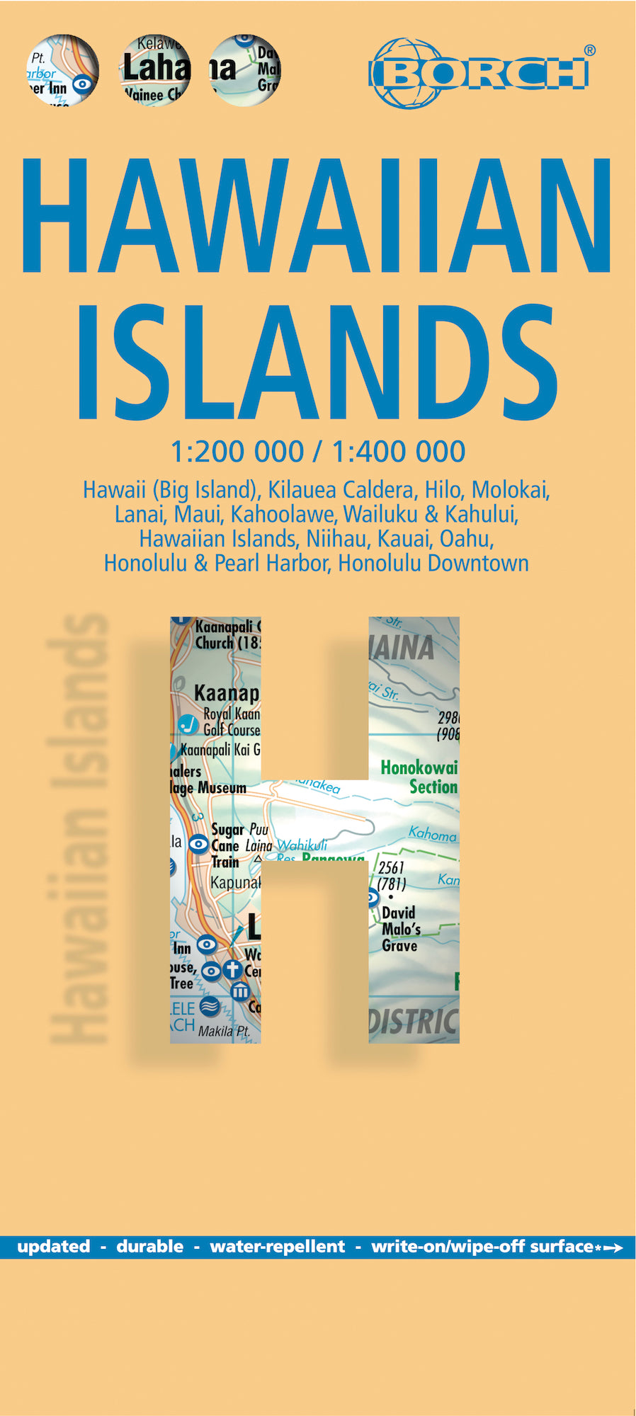
Hawaiian Islands Borch Folded Laminated Map
$21.95
Afterpay is only available for orders between $50.00 and $1000.00 More info
Durable, Water-Repellent | 13th Edition 2024 | Multiple Island & City Insets
Unfold paradise with the Hawaiian Islands Borch Folded Laminated Map—your essential travel companion to navigating America’s Pacific jewel. Designed for durability and ease of use, this map covers the entire Hawaiian Archipelago in exquisite detail, from the volcanic landscapes of the Big Island to the beaches of O‘ahu, the rainforests of Kaua‘i, and the valleys of Maui.
Whether you’re an island-hopping adventurer, a first-time visitor, or a lifelong resident seeking a premium reference map, this title combines precision cartography with cultural insight—ensuring you not only know where you are, but also understand what makes each place special.
🏝️ Detailed Map Coverage
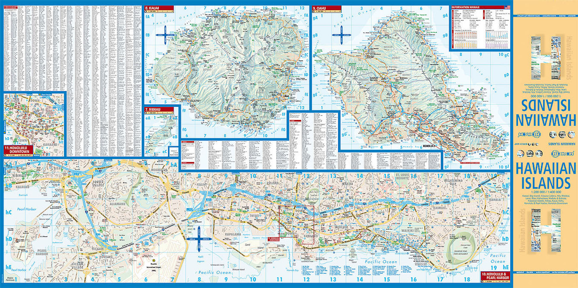
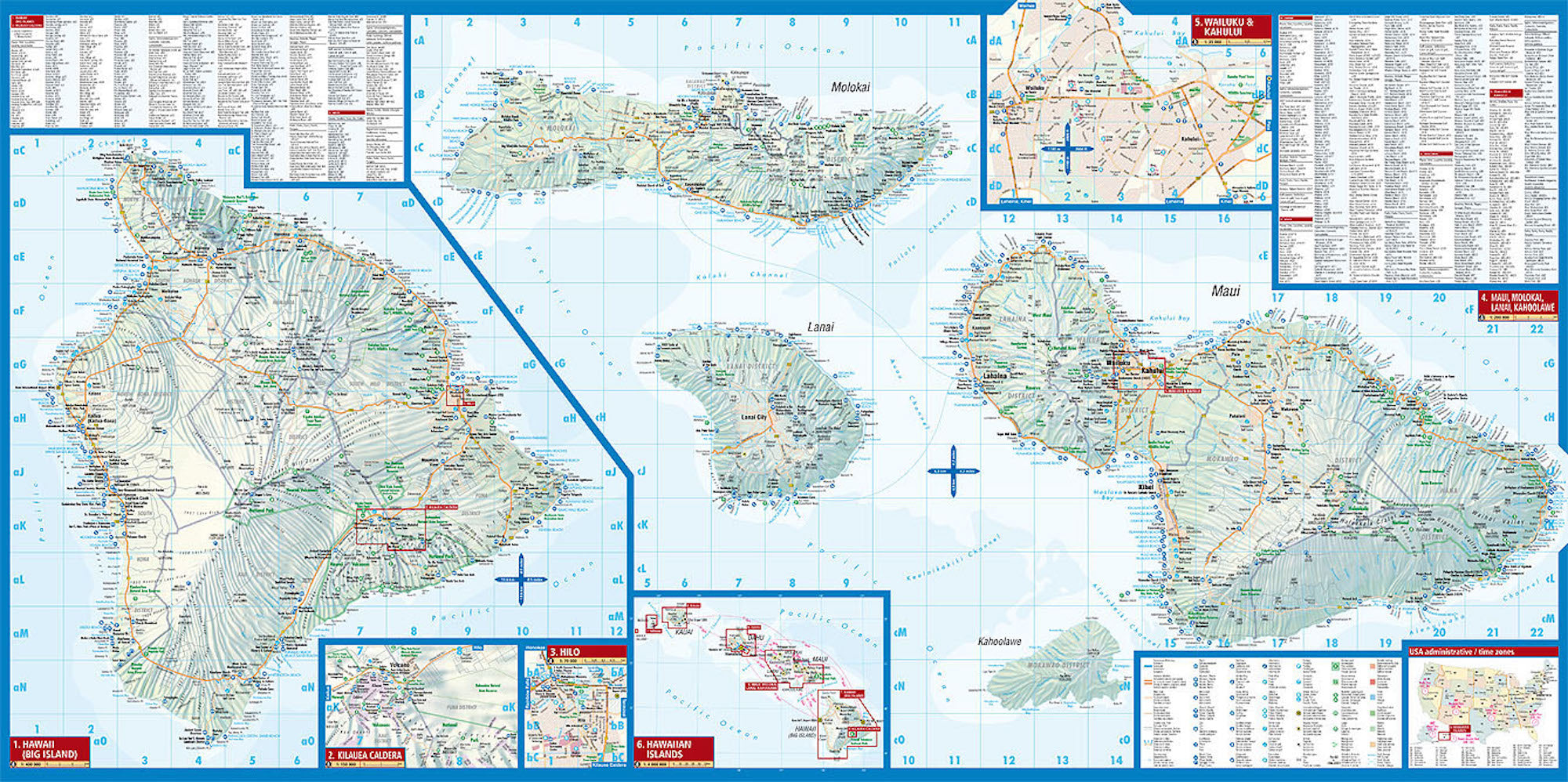
This 13th edition includes up-to-date mapping of all major Hawaiian islands, plus detailed city insets for key destinations:
-
Hawai‘i (Big Island) – 1:400,000
-
Kīlauea Caldera – 1:150,000
-
Hilo – 1:70,000
-
Maui, Moloka‘i, Lāna‘i, Kaho‘olawe – 1:200,000
-
Wailuku & Kahului – 1:35,000
-
Hawaiian Islands Overview – 1:4,000,000
-
Ni‘ihau – 1:400,000
-
Kaua‘i & O‘ahu – 1:200,000
-
Honolulu & Pearl Harbor – 1:26,000
-
Honolulu Downtown – 1:15,500
-
USA Administrative & Time Zones Map
🧭 Map Features
-
✅ Soft-Laminated Finish – water-repellent, tear-resistant, and wipe-clean for years of use.
-
✅ Easy-Fold Design – folds neatly without creases or damage, even after frequent handling.
-
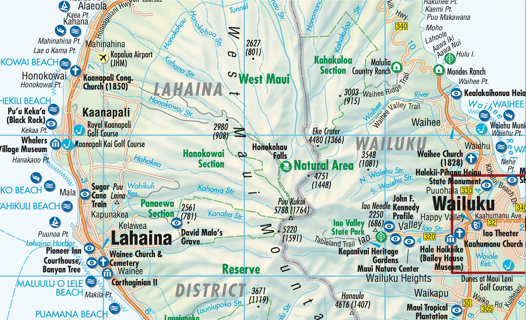
✅ Tourist & Cultural Highlights – hotels, museums, monuments, markets, top sights, and points of interest all clearly marked.
-
✅ Public Transport Information – bus stops, ferry terminals, airports, and other key transit hubs.
-
✅ Travel Planning Resources – climate charts showing temperatures, rainfall, sunshine hours, and humidity; conversion tables for temperature, weights, and measures.
-
✅ Statistics & Overview Maps – useful facts and at-a-glance reference for travel preparation.
📐 Specifications
| Specification | Detail |
|---|---|
| Title | Hawaiian Islands – Borch Folded Laminated Map |
| Scale | 1:200,000 / 1:400,000 (varies by inset) |
| ISBN | 978-3-86609-320-1 |
| Size (Unfolded) | 990 mm × 494 mm (39 in × 19.5 in) |
| Size (Folded) | 243 mm × 110 mm × 8 mm (9.6 in × 4.3 in × 0.3 in) |
| Weight | 82 g (2.9 oz) |
| Edition | 13th Edition, 2024 |
| Format | Folded, soft-laminated road & tourist map |
🌺 The Hawaiian Islands – More Than a Destination
Born of volcanic fire and surrounded by the vast Pacific Ocean, the Hawaiian Islands are as rich in history as they are in natural beauty. The eight principal islands together form the 50th state of the USA—the only one not connected to the North American continent.
Though the Hawaiian language is now spoken by relatively few, its influence is felt in every place name and greeting. Cultural traditions such as the hula, surfing, and the ceremonial gifting of leis remain central to island life. Visitors are greeted with an aloha spirit that is as genuine as it is legendary, welcoming travellers into a world of lush rainforests, volcanic craters, coral reefs, and golden beaches.
Mark Twain called Hawaii “the most charming fleet of islands that ever set sail”, and even today the description feels apt. Whether you come for adventure, relaxation, or cultural discovery, the islands promise experiences found nowhere else on earth.
🌍 Perfect For
-
✈️ Holidaymakers & Island Hoppers – plan routes between islands and find must-see sights at a glance.
-
🚗 Road Trippers – navigate the Big Island’s volcanic routes or Maui’s famed Hana Highway.
-
🛳️ Cruise Ship Passengers – explore ports of call with detailed city insets.
-
📚 Cultural Enthusiasts – use the map as a companion to Hawaiian history, traditions, and geography.
-
🎁 Map Collectors – a high-quality, durable addition to any world map collection.
✨ Why Choose a Borch Map?
Borch laminated maps are designed to last—perfect for repeated use in varying travel conditions. The soft-laminated finish offers durability without the bulk, while the precise cartography balances tourist information with accurate geographic detail. This makes it equally valuable for on-the-road navigation and as a keepsake after your journey.
Order your copy today and let the Hawaiian Islands Borch Folded Laminated Map guide you—whether your adventure takes you to the lava flows of Kīlauea, the surf breaks of O‘ahu’s North Shore, or the emerald cliffs of Kaua‘i’s Nā Pali Coast.
Frequently Asked Questions
Where can I buy the Hawaiian Islands Borch Folded Laminated Map?
The Hawaiian Islands Borch Folded Laminated Map is available to buy online from Mapworld, Australia's largest map and geographic product retailer, with fast shipping Australia-wide.
Is the Hawaiian Islands Borch Folded Laminated Map in stock at Mapworld?
Mapworld maintains extensive stock across its map range and aims for fast dispatch. Orders placed before 2pm AEST on business days are typically dispatched the same day, with standard and express Australia-wide delivery options available.
What is Mapworld's returns policy?
Mapworld accepts returns on undamaged items in original condition. Contact Mapworld within 90 days of purchase to arrange a return or exchange.
Does Mapworld ship the Hawaiian Islands Borch Folded Laminated Map across Australia?
Yes, Mapworld ships Australia-wide. Standard shipping is a flat $7 rate, with free standard shipping on orders over $75. Express options are available at checkout. Most orders placed before 2pm AEST on weekdays are dispatched same day.
Related Items


© 2026 Mapworld. Website designed by Genie Media
X