- Australia ▾
- Topographic
▾
- Australia AUSTopo 250k (2025)
- Australia 50k Geoscience maps
- Australia 100k Geoscience maps
- Australia 250k Geoscience maps
- Australia 1:1m Geoscience maps
- New Zealand 50k maps
- New Zealand 250k maps
- New South Wales 25k maps
- New South Wales 50k maps
- New South Wales 100k maps
- Queensland 10k maps
- Queensland 25k maps
- Queensland 50k maps
- Queensland 100k maps
- Western Australia 25k maps
- Western Australia 50k maps
- Western Australia 100k maps
- Compasses
- Software
- GPS Systems
- International ▾
- Wall Maps
▾
- World
- Australia & New Zealand
- Countries, Continents & Regions
- Historical
- Vintage National Geographic
- Australian Capital Territory
- New South Wales
- Northern Territory
- Queensland
- South Australia
- Tasmania
- Victoria
- Western Australia
- Celestial
- Children's
- Mining & Resources
- Wine Maps
- Healthcare
- Postcode Maps
- Electoral Maps
- Nautical ▾
- Flags
▾
- Australian Flag Sets & Banners
- Flag Bunting
- Handwavers
- Australian National Flags
- Aboriginal Flags
- Torres Strait Islander Flags
- International Flags
- Flagpoles & Accessories
- Australian Capital Territory Flags
- New South Wales Flags
- Northern Territory Flags
- Queensland Flags
- South Australia Flags
- Tasmania Flags
- Victoria Flags
- Western Australia Flags
- Gifts ▾
- Globes ▾
Dear valued customer. Please note that our checkout is not supported by old browsers. Please use a recent browser to access all checkout capabilities


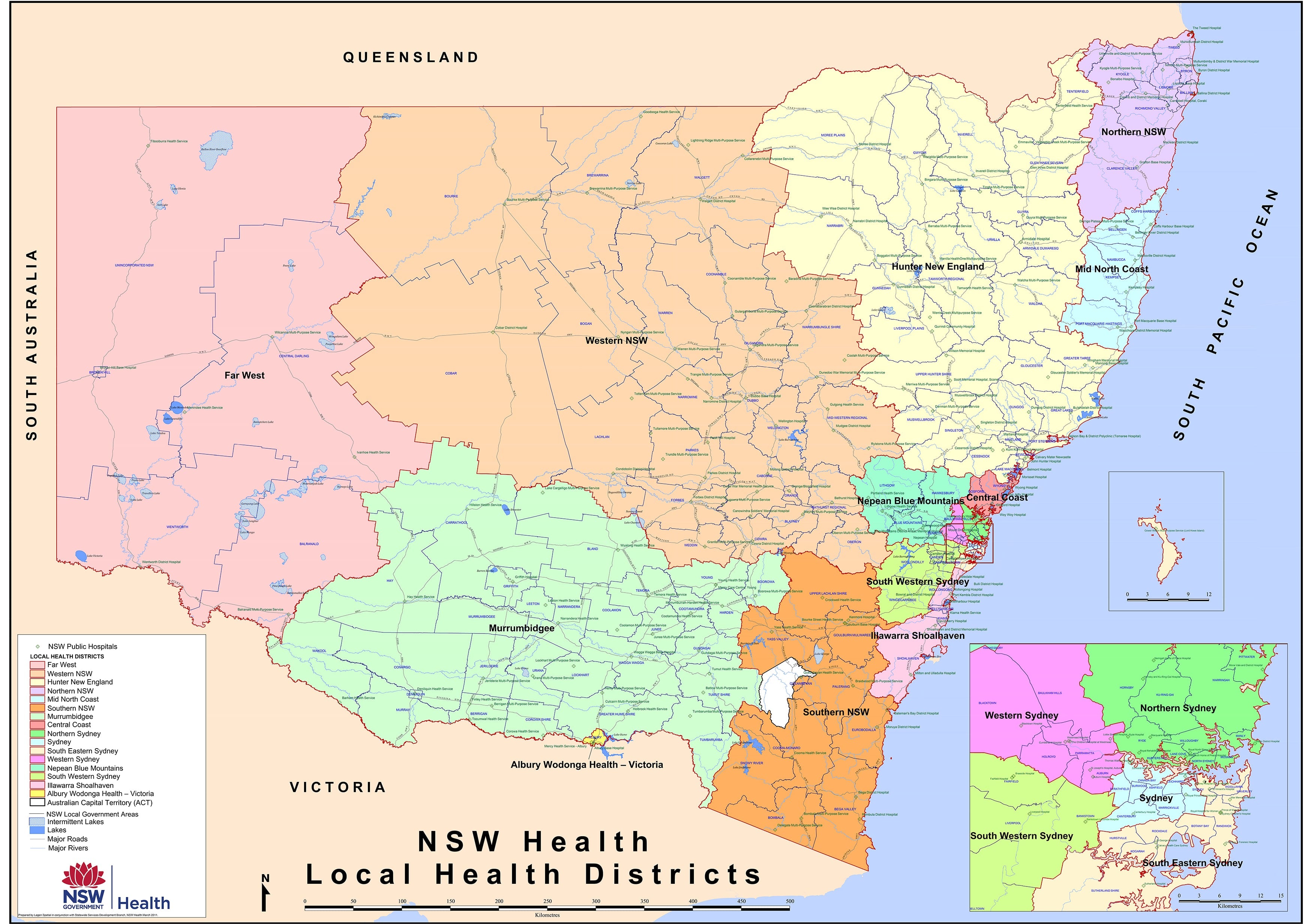
New South Wales Health & Hospitals Map 1190 x 870mm Wall Map
$69.95
or make 4 interest-free payments of
$17.49 AUD
fortnightly with
![]() More info
More info
Detailed Planning Map | 1190 x 870 mm | Laminated Finish Available
An essential reference for health professionals, administrators, government agencies, and emergency planners, the New South Wales Health & Hospitals Map provides a clear and comprehensive overview of the state’s public health infrastructure.
This large-format wall map presents critical administrative and geographical data, making it ideal for strategic planning, resource allocation, and operational logistics across NSW’s health network.
🔍 Key Features
| Category | Details |
|---|---|
| Map Focus | Health Districts, Public Hospitals, LGAs, Roads |
| Coverage | Entire state of New South Wales |
| Map Format | Wall Map (Flat) |
| Finish Options | Laminated or Paper |
| Size | 1190 mm (w) × 870 mm (h) |
🏨 What This Map Shows
-
NSW Local Health District Boundaries: Clearly delineated to help visualise catchment areas and jurisdictions.
-
Public Hospital Locations: Every NSW public hospital is accurately marked, enabling rapid identification of facilities.
-
Local Government Areas (LGAs): LGA boundaries provide important administrative context for healthcare governance.
-
Major Roads & Highways: An essential inclusion for logistics, travel-time assessments, and emergency access routes.
🖊️ Laminated for Utility
This map is available in a high-quality gloss laminate, allowing for practical use in dynamic settings:
-
Write and wipe with whiteboard markers
-
Apply map dots or pins for planning, training, or coordination
-
Easy to clean and resistant to tears, creases, and spills
Whether you're in a hospital boardroom, local health office, ambulance command centre, or state department, this map is built for daily use.
🧭 Ideal For:
-
Health Planners & Administrators
-
Emergency Services & Crisis Management Teams
-
Hospital Management & Regional Health Boards
-
Public Health Policy and Research
-
Educational Institutions in Health & Urban Planning
✅ Practical and Professional
Designed to meet the needs of busy professionals, this map combines clarity with accuracy. It’s perfect for wall mounting in offices, operations centres, or classrooms where having a clear view of NSW’s health geography is critical.
Plan smarter. Act faster. See the whole picture.
This is the definitive NSW health and hospital reference map.
Frequently Asked Questions
What are the dimensions of the New South Wales Health & Hospitals Map 1190 x 870mm Wall Map?
Mapworld wall maps range from standard 700×1000mm to large-format 1000×1430mm Supermaps. The exact dimensions for this map are shown in the product title. Where multiple sizes are available, select your preferred size when adding to cart.
Is this wall map available laminated?
Many Mapworld wall maps are available in paper, laminated, or framed finishes. Check the product options when adding to cart. Laminated maps are wipe-clean and more durable.
Is this the latest edition?
Mapworld stocks the most current editions available from all publishers. Edition year is shown in the product title where applicable. Mapworld updates its catalogue as new editions are released.
Can I write on or pin this wall map?
Laminated wall maps can be written on with whiteboard markers and wiped clean. Paper maps can be pinned on a corkboard. Choose a laminated option for a writeable surface.
Does Mapworld ship the New South Wales Health & Hospitals Map 1190 x 870mm Wall Map across Australia?
Yes, Mapworld ships Australia-wide. Standard shipping is a flat $7 rate, with free standard shipping on orders over $75. Express options are available at checkout. Most orders placed before 2pm AEST on weekdays are dispatched same day.
Related Items


© 2026 Mapworld. Website designed by Genie Media
X