- Australia ▾
- Topographic
▾
- Australia AUSTopo 250k (2025)
- Australia 50k Geoscience maps
- Australia 100k Geoscience maps
- Australia 250k Geoscience maps
- Australia 1:1m Geoscience maps
- New Zealand 50k maps
- New Zealand 250k maps
- New South Wales 25k maps
- New South Wales 50k maps
- New South Wales 100k maps
- Queensland 10k maps
- Queensland 25k maps
- Queensland 50k maps
- Queensland 100k maps
- Western Australia 25k maps
- Western Australia 50k maps
- Western Australia 100k maps
- Compasses
- Software
- GPS Systems
- International ▾
- Wall Maps
▾
- World
- Australia & New Zealand
- Countries, Continents & Regions
- Historical
- Vintage National Geographic
- Australian Capital Territory
- New South Wales
- Northern Territory
- Queensland
- South Australia
- Tasmania
- Victoria
- Western Australia
- Celestial
- Children's
- Mining & Resources
- Wine Maps
- Healthcare
- Postcode Maps
- Electoral Maps
- Nautical ▾
- Flags
▾
- Australian Flag Sets & Banners
- Flag Bunting
- Handwavers
- Australian National Flags
- Aboriginal Flags
- Torres Strait Islander Flags
- International Flags
- Flagpoles & Accessories
- Australian Capital Territory Flags
- New South Wales Flags
- Northern Territory Flags
- Queensland Flags
- South Australia Flags
- Tasmania Flags
- Victoria Flags
- Western Australia Flags
- Gifts ▾
- Globes ▾
Dear valued customer. Please note that our checkout is not supported by old browsers. Please use a recent browser to access all checkout capabilities


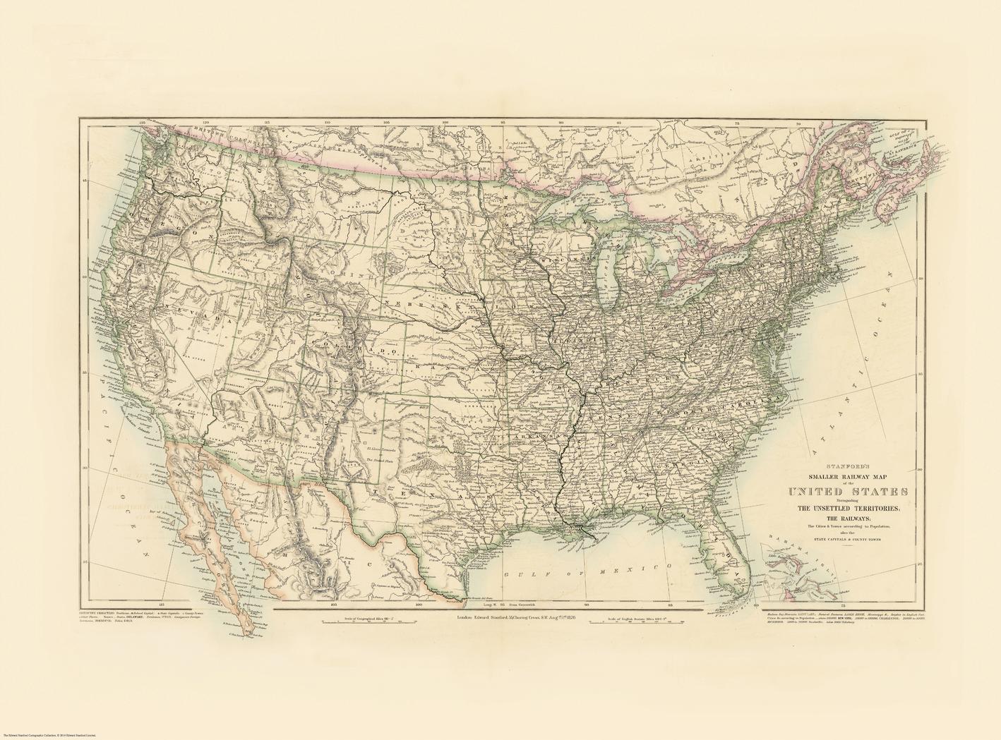
Stanford's Railway Map of the United States published 1876
$79.95
or make 4 interest-free payments of
$19.99 AUD
fortnightly with
![]() More info
More info
Rails, States & Cities — Stanford’s Railway Map of the United States (1876)
A snapshot of a nation in the age of steam, rendered with clarity and restraint. This United States sheet—published in 1876 as Stanford’s Folio Smaller Railway Map and reproduced from the Edward Stanford Cartographic Collection—brings the post–Civil War network into sharp focus. Main and subsidiary railway lines, junctions, state boundaries, towns and cities, and hydrography (rivers, lakes, coastline) are set out in clean, legible cartography that rewards both room-distance viewing and close study. It’s the fabric of rail-era America—connected, navigable, and unmistakably of its time—made to study, admire, and display.
More Than a Map – A Testament to History
This isn’t just wall art—it’s a reference frame for how the United States moved goods, people, and ideas in the Centennial year. Every route, crossing, and boundary captures commerce, migration, and regional growth at a pivotal moment. Ideal for educators, genealogists, historians, designers, and collectors, this sheet stands alone beautifully and pairs powerfully with modern transport maps for then-and-now comparisons.
Hang it in studios, libraries, classrooms, museums, offices, or at home to invite reflection, study, and conversation.
Premium Materials & Finishes
We treat history with the respect it deserves. That’s why we offer multiple formats, each produced using high-quality materials and modern archival printing.
🌟 Archival Paper Print
Printed on heavyweight 160gsm archival-grade paper.
Smooth matte finish reduces glare and preserves fine linework and small labels.
Ideal for framing under glass—clean, timeless, and built to last.
💎 Laminated Edition
Encapsulated in two sheets of 80-micron gloss laminate using true thermal bonding—not just surface lamination.
Moisture-resistant, wipe-clean surface—perfect for classrooms and high-traffic reference spaces.
Great for research: use whiteboard markers or apply map dots to mark locations without permanently altering the map.
ptional Natural Timber Hang Rails: lacquered rails with a fitted hanging cord provide a polished, ready-to-hang presentation—no frame required. (Please allow up to 10 working days for delivery with hang rails.)
🏆 Museum-Quality Canvas
Printed on heavyweight 395gsm HP Professional Matte Canvas for rich texture and exceptional strength.
Pigment-based, fade-resistant inks deliver deep tone and crisp typography that endure for generations.
Optional Natural Timber Hang Rails: lacquered to enhance the wood grain and protect against wear; top cord for effortless hanging—elegant in any setting. (Please allow up to 10 working days for delivery with hang rails.)
Specifications
| Feature | Details |
|---|---|
| Title | Stanford’s Railway Map of the United States |
| Series | Stanford’s Folio Smaller series (reproduction from the Edward Stanford Cartographic Collection) |
| Original Publication | 1876 |
| Scale | Not specified |
| Cartographic Content | Railways (main & subsidiary); stations/junctions; state boundaries; towns/cities; rivers; lakes; coastline |
| Map Size | 1000 mm (W) × 740 mm (H) |
| Available Formats | Paper, Laminated, Canvas |
| Paper Weight | 160gsm archival-quality |
| Laminate | 2 × 80-micron gloss laminate sheets (encapsulated) |
| Canvas Weight | 395gsm HP Professional Matte Canvas |
| Inks | Pigment-based, fade-resistant |
| Optional Hang Rails | Available on Laminated & Canvas (lead time up to 10 working days) |
| Origin | Made in Australia |
Why Choose This Map
✔ Era-True Snapshot: America’s railway geography as presented in 1876.
✔ Clarity at Scale: Elegant symbology reads beautifully across a room and up close.
✔ Genealogy & Research Friendly: Laminated option supports dry-erase notes and map dots.
✔ Decorative & Scholarly: Strong wall presence with genuine reference value.
✔ Archival Craft: Premium substrates and inks preserve contrast, labels, and linework for decades.
Our Commitment
We believe that preserving history is as important as telling it. Every map is printed locally in Australia using state-of-the-art technology, carefully checked by hand, and packed with care. From the moment it leaves our workshop to the day it hangs on your wall, we ensure quality you can trust and a legacy you’ll be proud to share.
Bring the age of steam into focus. Order the Stanford’s Railway Map of the United States (1876) today—a faithful, beautifully produced sheet that turns a room into a conversation.
Frequently Asked Questions
What are the dimensions of the Stanford's Railway Map of the United States published 1876?
Mapworld wall maps range from standard 700×1000mm to large-format 1000×1430mm Supermaps. The exact dimensions for this map are shown in the product title. Where multiple sizes are available, select your preferred size when adding to cart.
Is this wall map available laminated?
Many Mapworld wall maps are available in paper, laminated, or framed finishes. Check the product options when adding to cart. Laminated maps are wipe-clean and more durable.
Is this the latest edition?
Mapworld stocks the most current editions available from all publishers. Edition year is shown in the product title where applicable. Mapworld updates its catalogue as new editions are released.
Can I write on or pin this wall map?
Laminated wall maps can be written on with whiteboard markers and wiped clean. Paper maps can be pinned on a corkboard. Choose a laminated option for a writeable surface.
Does Mapworld ship the Stanford's Railway Map of the United States published 1876 across Australia?
Yes, Mapworld ships Australia-wide. Standard shipping is a flat $7 rate, with free standard shipping on orders over $75. Express options are available at checkout. Most orders placed before 2pm AEST on weekdays are dispatched same day.
Related Items


© 2026 Mapworld. Website designed by Genie Media
X