

A Striking Cartographic Tribute to the Earth's Last Frontier
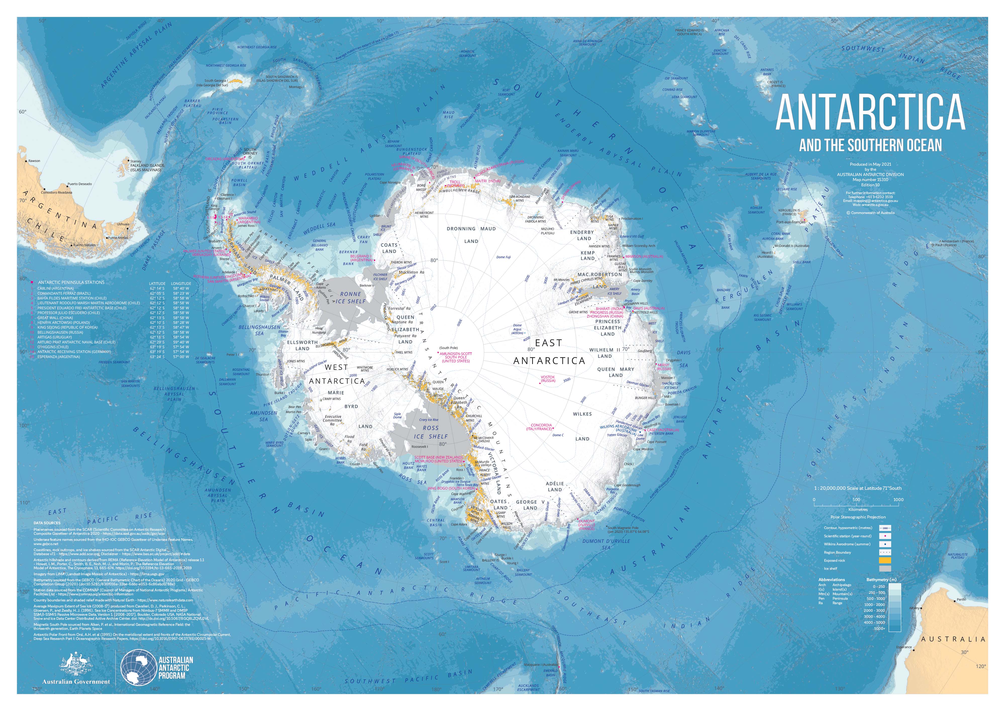
This beautifully rendered wall map of Antarctica and the Southern Ocean captures the stark majesty and critical detail of the southernmost continent with exceptional clarity. From the intricate ice shelves fringing the coastline to the deep, cold waters of the Southern Ocean, this map is as informative as it is visually stunning.
Designed with a balance of scientific precision and aesthetic appeal, this map is perfect for classrooms, research spaces, offices, or any room with an interest in geography, climate, or exploration.
Key Features
-
Detailed Antarctic Mapping
Shows the full Antarctic continent in exquisite detail, including:-
15 permanent research stations across the Antarctic Peninsula
-
Airfields, runways, and logistical infrastructure
-
Major ice shelves, glaciers, and exposed rock formations
-
-
Southern Ocean Bathymetry
Ocean depths are represented using a graduated colour scheme, shifting from icy white to rich teal and deep blue:-
Depths over 5,000 metres are clearly distinguished
-
Continental shelf boundaries and underwater features are mapped in detail
-
-
Geographic & Political Context
Includes longitude/latitude markings, international territorial claims, and zones of scientific interest as governed by the Antarctic Treaty System.
📐 Available Sizes
| Format | Dimensions (W x H) |
|---|---|
| Standard | 1000 mm x 700 mm |
| Large | 1400 mm x 1000 mm |
| Oversized Statement Map | 2000 mm x 1400 mm |
🖼️ Finishing Options
1. Premium Paper (160 gsm)
Perfect for framing under glass, this heavyweight coated paper finish delivers crisp colour definition and fine detail.
2. Encapsulated Lamination (80-micron gloss laminate)
Provides excellent durability for heavy use.
-
Use whiteboard markers or map dots
-
Wipeable, tear-resistant, and moisture-protected
-
Ideal for field stations, classrooms, and professional settings
- Optional wooden hang rails (lacquered timber) available for instant wall display
3. Museum-Grade Canvas (395 gsm HP Professional Matte)
Printed with archival pigment-based inks for fade resistance and deep contrast, this version is both tactile and visually luxurious.
-
A stunning feature piece in home offices or studios
-
Optional wooden hang rails (lacquered timber) available for instant wall display
-
Hanging cord pre-attached for ease of installation
Please allow 10 working days for delivery of maps with hang rails, as these are hand-finished by our in-house framer.
🎯 Ideal For
-
Academic institutions and libraries
-
Environmental and climate science offices
-
Expedition planning and polar research facilities
-
Travel enthusiasts and cartography collectors
-
Anyone fascinated by the remote, icy edge of the world
Antarctica may be a continent few will ever step foot on, but with this map on your wall, the spirit of polar exploration and scientific discovery is never far from view.


