- Australia ▾
- Topographic
▾
- Australia AUSTopo 250k (2025)
- Australia 50k Geoscience maps
- Australia 100k Geoscience maps
- Australia 250k Geoscience maps
- Australia 1:1m Geoscience maps
- New Zealand 50k maps
- New Zealand 250k maps
- New South Wales 25k maps
- New South Wales 50k maps
- New South Wales 100k maps
- Queensland 10k maps
- Queensland 25k maps
- Queensland 50k maps
- Queensland 100k maps
- Western Australia 25k maps
- Western Australia 50k maps
- Western Australia 100k maps
- Compasses
- Software
- GPS Systems
- International ▾
- Wall Maps
▾
- World
- Australia & New Zealand
- Countries, Continents & Regions
- Historical
- Vintage National Geographic
- Australian Capital Territory
- New South Wales
- Northern Territory
- Queensland
- South Australia
- Tasmania
- Victoria
- Western Australia
- Celestial
- Children's
- Mining & Resources
- Wine Maps
- Healthcare
- Postcode Maps
- Electoral Maps
- Nautical ▾
- Flags
▾
- Australian Flag Sets & Banners
- Flag Bunting
- Handwavers
- Australian National Flags
- Aboriginal Flags
- Torres Strait Islander Flags
- International Flags
- Flagpoles & Accessories
- Australian Capital Territory Flags
- New South Wales Flags
- Northern Territory Flags
- Queensland Flags
- South Australia Flags
- Tasmania Flags
- Victoria Flags
- Western Australia Flags
- Gifts ▾
- Globes ▾
Dear valued customer. Please note that our checkout is not supported by old browsers. Please use a recent browser to access all checkout capabilities


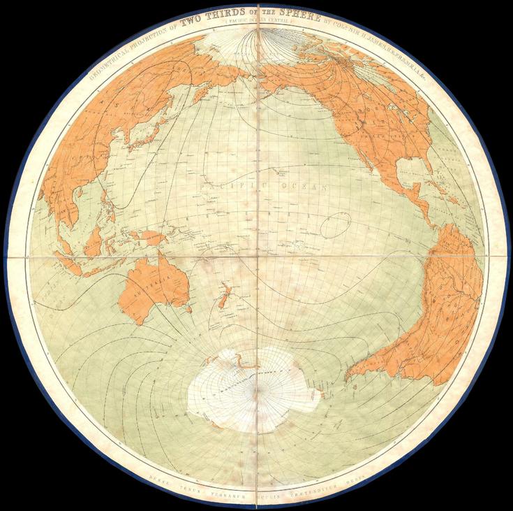
James Polar Projection of the Globe, Pacific Center (1860) Wall Map
$109.95
or make 4 interest-free payments of
$27.49 AUD
fortnightly with
![]() More info
More info
Polar Geometry & Sea-Lanes — James’s Pacific-Centred Globe (1860)
A snapshot of the world reimagined from the pole, rendered with clarity and restraint. This Pacific-centred polar projection—devised by Major General Sir Henry James, Director-General of the British Ordnance Survey, and published in 1860—presents two-thirds of the sphere in a single, elegant construct. Continental outlines, ocean basins, and a crisp graticule of meridians and parallels are set out in clean, legible cartography that rewards both room-distance viewing and close study. It’s the globe as geometry—precise, comparative, and unmistakably of its era—made to study, admire, and display.
More Than a Map – A Testament to History
This isn’t just wall art—it’s a nineteenth-century exercise in mathematical cartography and global perspective. By centring the Pacific, the projection rebalances familiar relationships among the Americas, Asia, and Oceania, revealing routes and regions often split by traditional Atlantic-centred views. Ideal for educators, navigational historians, designers, and collectors, this sheet stands alone beautifully and pairs powerfully with modern world projections for then-and-now comparison.
Hang it in studios, libraries, classrooms, museums, offices, or at home to invite reflection, study, and conversation.
Premium Materials & Finishes
We treat history with the respect it deserves. That’s why we offer multiple formats, each produced using high-quality materials and modern archival printing.
🌟 Archival Paper Print
Printed on heavyweight 160gsm archival-grade paper.
Smooth matte finish reduces glare and preserves fine linework and small labels.
Ideal for framing under glass—clean, timeless, and built to last.
💎 Laminated Edition
Encapsulated in two sheets of 80-micron gloss laminate using true thermal bonding—not just surface lamination.
Moisture-resistant, wipe-clean surface; the laminate also helps filter UV, reducing fade over time.
Optional Natural Timber Hang Rails: lacquered rails with a fitted hanging cord provide a polished, ready-to-hang presentation—no frame required. (Please allow up to 10 working days for delivery with hang rails.)
🏆 Museum-Quality Canvas
Printed on heavyweight 395gsm HP Professional Matte Canvas for rich texture and exceptional strength.
Pigment-based, fade-resistant inks deliver deep tone and crisp typography that endure for generations.
Optional Natural Timber Hang Rails: lacquered to enhance the wood grain and protect against wear; top cord for effortless hanging—elegant in any setting. (Please allow up to 10 working days for delivery with hang rails.)
Specifications
| Feature | Details |
|---|---|
| Title | James’s Pacific-Centred Polar Projection of the Globe |
| Full Original Title | Geometrical Projection of Two-Thirds of the Sphere by Col. Sir H. James, R.E., F.R.S., M.R.I.A., &c. |
| Original Publication | 1860 |
| Projection | Polar, Pacific-centred (geometrical projection showing two-thirds of the sphere) |
| Cartographic Content | Continental outlines; oceans; graticule (meridians & parallels); projection framework |
| Map Size | 1000 mm (W) × 994 mm (H) |
| Available Formats | Paper, Laminated, Canvas |
| Paper Weight | 160gsm archival-quality |
| Laminate | 2 × 80-micron gloss laminate sheets (encapsulated; UV-filtering) |
| Canvas Weight | 395gsm HP Professional Matte Canvas |
| Inks | Pigment-based, fade-resistant |
| Optional Hang Rails | Available on Laminated & Canvas (lead time up to 10 working days) |
| Origin | Made in Australia |
Why Choose This Map
✔ Perspective Shift: A Pacific-centred view that reunites oceanic regions often split on standard maps.
✔ Geometric Elegance: A classic polar projection illustrating two-thirds of the sphere with precision.
✔ Decorative & Scholarly: Striking wall presence with genuine reference value.
✔ Research-Friendly: Laminated option supports dry-erase notes and map dots without permanent marks.
✔ Archival Craft: Premium substrates and inks preserve contrast, labels, and linework for decades.
Our Commitment
We believe that preserving history is as important as telling it. Every map is printed locally in Australia using state-of-the-art technology, carefully checked by hand, and packed with care. From the moment it leaves our workshop to the day it hangs on your wall, we ensure quality you can trust and a legacy you’ll be proud to share.
Shift your world view. Order the James’s Pacific-Centred Polar Projection (1860) today—a faithful, beautifully produced sheet that turns a room into a conversation.
Frequently Asked Questions
What diameter is the James Polar Projection of the Globe, Pacific Center (1860) Wall Map?
Mapworld stocks globes from compact 15–20cm desktop models to large 40–50cm floor-standing globes. The diameter for this globe is shown in the product title. Desktop globes suit home and office use; floor-standing models are ideal for larger spaces.
Is this globe illuminated?
Mapworld stocks both illuminated (LED/light-up) and non-illuminated globes. Illuminated models are identified in the product title with terms such as 'illuminated', 'light-up', or 'LED'. If the product title does not include those terms, the globe is non-illuminated.
Is this globe suitable as a gift?
Yes, globes make excellent gifts for geography enthusiasts, travellers, students, and professionals. Mapworld ships globes with protective packaging.
Is this globe suitable for educational use?
Yes, most globes in Mapworld's range are suitable for home, classroom, and office use. Replogle globes are designed for all ages and display accurate political and physical geography. Smaller desk globes (20–26 cm diameter) are ideal for school use, while larger floor-standing models suit libraries and executive offices.
Does Mapworld ship the James Polar Projection of the Globe, Pacific Center (1860) Wall Map across Australia?
Yes, Mapworld ships Australia-wide. Standard shipping is a flat $7 rate, with free standard shipping on orders over $75. Express options are available at checkout. Most orders placed before 2pm AEST on weekdays are dispatched same day.
Related Items


© 2026 Mapworld. Website designed by Genie Media
X