- Australia ▾
- Topographic
▾
- Australia AUSTopo 250k (2025)
- Australia 50k Geoscience maps
- Australia 100k Geoscience maps
- Australia 250k Geoscience maps
- Australia 1:1m Geoscience maps
- New Zealand 50k maps
- New Zealand 250k maps
- New South Wales 25k maps
- New South Wales 50k maps
- New South Wales 100k maps
- Queensland 10k maps
- Queensland 25k maps
- Queensland 50k maps
- Queensland 100k maps
- Compasses
- Software
- GPS Systems
- Orienteering
- International ▾
- Wall Maps
▾
- World
- Australia & New Zealand
- Countries, Continents & Regions
- Historical
- Vintage National Geographic
- Australian Capital Territory
- New South Wales
- Northern Territory
- Queensland
- South Australia
- Tasmania
- Victoria
- Western Australia
- Celestial
- Children's
- Mining & Resources
- Wine Maps
- Healthcare
- Postcode Maps
- Electoral Maps
- Nautical ▾
- Flags
▾
- Australian Flag Sets & Banners
- Flag Bunting
- Handwavers
- Australian National Flags
- Aboriginal Flags
- Torres Strait Islander Flags
- International Flags
- Flagpoles & Accessories
- Australian Capital Territory Flags
- New South Wales Flags
- Northern Territory Flags
- Queensland Flags
- South Australia Flags
- Tasmania Flags
- Victoria Flags
- Western Australia Flags
- Gifts ▾
- Globes ▾
Dear valued customer. Please note that our checkout is not supported by old browsers. Please use a recent browser to access all checkout capabilities


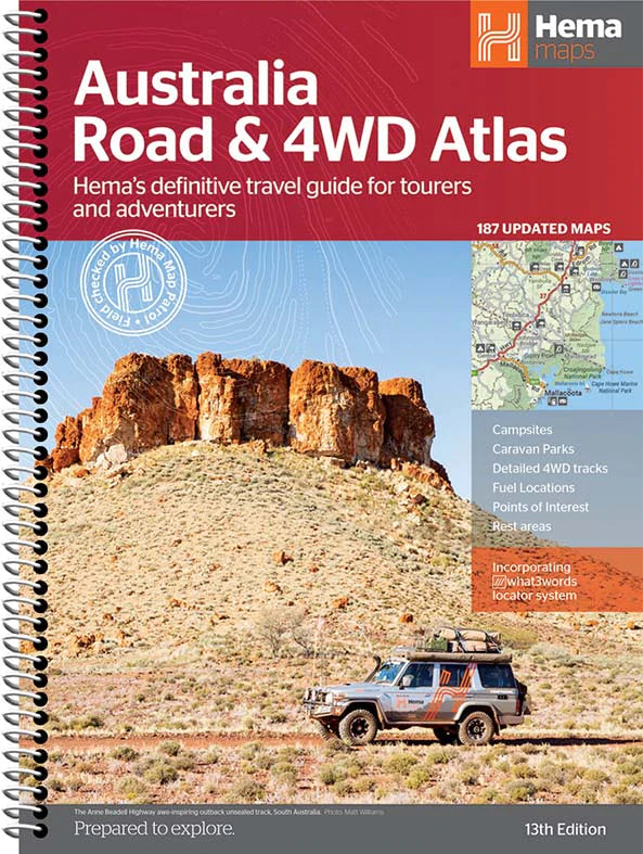
Australia Hema Road and 4WD Atlas New 13th Edition Spiral Bound
$49.95
Afterpay is only available for orders between $50.00 and $1000.00 More info
Navigate the Road Less Travelled with Confidence, Clarity and the Power of Hema Mapping
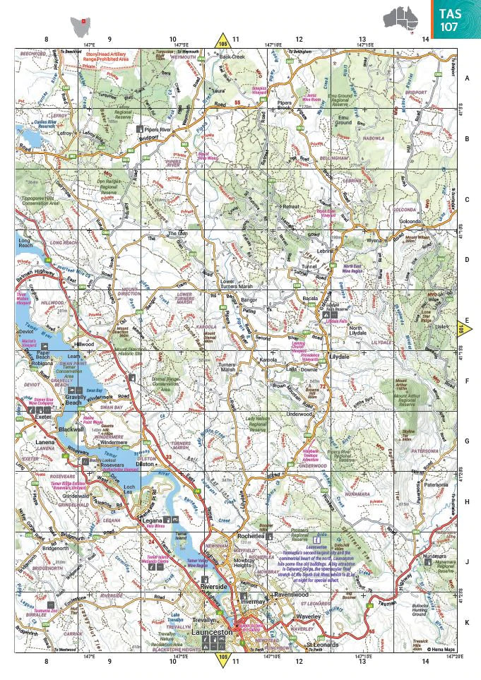
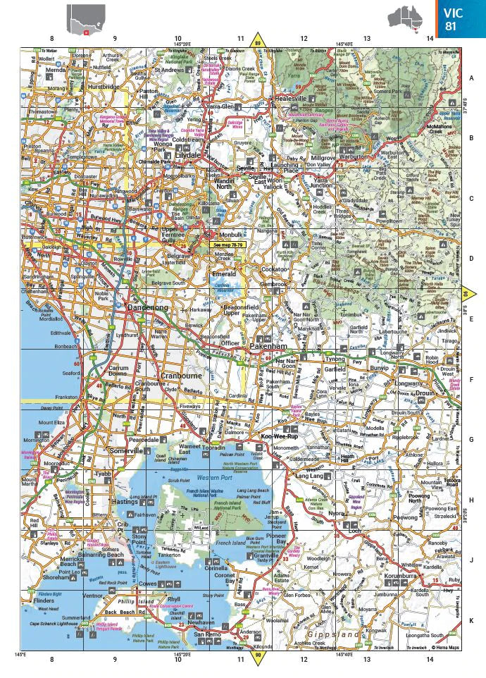
Whether you're crossing the Nullarbor, meandering through the Great Ocean Road, or taking the dusty red trails of the Top End, the Hema Road & 4WD Easy Read Atlas is the ultimate resource for Australian road trips and off-road adventures. Trusted by seasoned explorers, grey nomads, families, and weekend 4WDers alike, this atlas combines Hema’s famously accurate cartography with a layout that’s easy on the eyes and loaded with practical travel details.
With more maps, more 4WD tracks, and more campsites than ever before, the latest edition of this national favourite is a must-have for anyone who wants to see the real Australia—beyond the main highways and tourist towns.
What Makes This Atlas the Travellers’ Favourite?
✅ Expert Mapping by Hema
Hema Maps are field-checked and updated by professional cartographers and 4WD explorers. This isn’t just a printed database—it’s the result of on-the-ground research, satellite verification, and years of travel expertise.
✅ Bigger, Bolder, Easier-to-Read
The Easy Read edition lives up to its name. With larger fonts, cleaner icons, and a modern cartographic style, the maps are simple to read even while navigating behind the wheel or from the passenger seat of a moving vehicle.
✅ Covers All of Australia – Including 4WD Hotspots
This edition includes more mapping coverage than ever before, with detailed insets and route planning for some of Australia’s most iconic off-road and adventure destinations:
-
Cape York
-
Fraser Island (K’gari)
-
The Kimberley
-
The Pilbara
-
The Red Centre
-
The Top End
-
Victorian High Country
-
Flinders Ranges
From beach tracks and escarpment trails to high-country switchbacks, these are must-see locations for every serious road-tripper or 4WD enthusiast.
🚗 Built for Travellers, Not Just Drivers
What sets the Hema Road & 4WD Easy Read Atlas apart is the abundance of travel-specific information packed into every page. You’ll find everything you need for planning, navigating, and making the most of your journey.
🛣️ Key Features:
-
Comprehensive Road Mapping – Includes sealed roads, unsealed routes, and remote tracks
-
Detailed 4WD Track Markings – With difficulty ratings and access notes
-
Campsites & Rest Areas – Great for free campers and those avoiding commercial parks
-
Caravan Parks – Clearly shown for trip planning with larger rigs
-
National Parks & Nature Reserves – Find your next hike, waterfall, or secluded overnight stop
-
24-Hour Fuel Locations – Crucial for remote stretches
-
Points of Interest – Historical towns, lookout points, tourist attractions, scenic byways
-
Distance Grid & Road Distances – Plan your days with realistic travel times
-
Accredited Visitor Information Centres – Get face-to-face guidance from local experts
-
National Park Directory – Quick reference to all major protected areas
-
Complete Index – Find even the smallest towns, roads, or reserves quickly
📏 Product Specifications
-
Title: Hema Road & 4WD Easy Read Atlas
-
Format: Large-format paperback atlas
-
Pages: 224 pages of full-colour, high-resolution mapping and guides
-
Size: 345mm x 252mm
-
Binding: Durable spine for repeated use on the road
-
Publisher: Hema Maps – Australia’s most trusted travel cartographer
-
Weight: Approx. 1.3kg
-
Edition: Latest release with updated content and map design
🧭 Who Is This Atlas Designed For?
This atlas is ideal for:
-
4WD enthusiasts navigating Australia’s remote terrain
-
Caravanners towing big rigs and needing reliable route and stopover info
-
Families planning outback holidays or coastal getaways
-
Grey nomads doing the Big Lap or extended seasonal tours
-
Adventure travellers heading to off-grid bushland and remote parks
-
First-time road trippers looking for a dependable, no-battery-required navigation backup
-
Gift-givers looking for a practical and inspiring book for travellers
Whether you're chasing red dust sunsets or stopping at every bakery in every town, this atlas makes it easier to get there and enjoy the ride.
💬 Customer Reviews
“This atlas never leaves our dashboard. Hema’s maps are spot on, and the extra info for fuel, camping, and 4WD tracks has saved us time and money.”
— Rob & Lisa, QLD
“Easy to read, especially when navigating solo. It’s laid out really well and covers everywhere we’ve been and plan to go.”
— Dave, NSW
“We won’t travel without this atlas. Perfect for planning ahead, and the points of interest are great for spontaneous side trips.”
— Karen, WA
Ready to Travel Smarter, Safer, and With More Confidence?
Whether you're navigating sealed highways or off-grid tracks, the Hema Road & 4WD Easy Read Atlas is the ultimate guide to travelling Australia with freedom and peace of mind. Field-tested, expertly mapped, and beautifully designed, it’s more than a road atlas—it’s a travel essential.
Frequently Asked Questions
What does the Australia Hema Road and 4WD Atlas New 13th Edition Spiral Bound cover?
This atlas covers the geographic region indicated in the product title, including roads, towns, distances, and key travel information. Mapworld stocks atlases for Australian states and territories, 4WD regions, and international destinations.
Is this the latest edition?
Yes, this is the 13th Edition. Mapworld stocks the most current editions available from publishers.
Is this atlas or guide spiral bound?
Spiral binding is indicated in the product title where applicable. Spiral-bound atlases and guides lay flat when open, making them ideal for use in vehicles or on a table without needing to hold pages open.
Is the Australia Hema Road and 4WD Atlas New 13th Edition Spiral Bound in stock at Mapworld?
Mapworld maintains extensive stock across its map range and aims for fast dispatch. Orders placed before 2pm AEST on business days are typically dispatched the same day, with standard and express Australia-wide delivery options available.
Does Mapworld ship the Australia Hema Road and 4WD Atlas New 13th Edition Spiral Bound across Australia?
Yes, Mapworld ships Australia-wide. Standard shipping is a flat $7 rate, with free standard shipping on orders over $75. Express options are available at checkout. Most orders placed before 2pm AEST on weekdays are dispatched same day.
Related Items


© 2026 Mapworld. Website designed by Genie Media
X