- Australia ▾
- Topographic
▾
- Australia AUSTopo 250k (2025)
- Australia 50k Geoscience maps
- Australia 100k Geoscience maps
- Australia 250k Geoscience maps
- Australia 1:1m Geoscience maps
- New Zealand 50k maps
- New Zealand 250k maps
- New South Wales 25k maps
- New South Wales 50k maps
- New South Wales 100k maps
- Queensland 10k maps
- Queensland 25k maps
- Queensland 50k maps
- Queensland 100k maps
- Compasses
- Software
- GPS Systems
- Orienteering
- International ▾
- Wall Maps
▾
- World
- Australia & New Zealand
- Countries, Continents & Regions
- Historical
- Vintage National Geographic
- Australian Capital Territory
- New South Wales
- Northern Territory
- Queensland
- South Australia
- Tasmania
- Victoria
- Western Australia
- Celestial
- Children's
- Mining & Resources
- Wine Maps
- Healthcare
- Postcode Maps
- Electoral Maps
- Nautical ▾
- Flags
▾
- Australian Flag Sets & Banners
- Flag Bunting
- Handwavers
- Australian National Flags
- Aboriginal Flags
- Torres Strait Islander Flags
- International Flags
- Flagpoles & Accessories
- Australian Capital Territory Flags
- New South Wales Flags
- Northern Territory Flags
- Queensland Flags
- South Australia Flags
- Tasmania Flags
- Victoria Flags
- Western Australia Flags
- Gifts ▾
- Globes ▾
Dear valued customer. Please note that our checkout is not supported by old browsers. Please use a recent browser to access all checkout capabilities


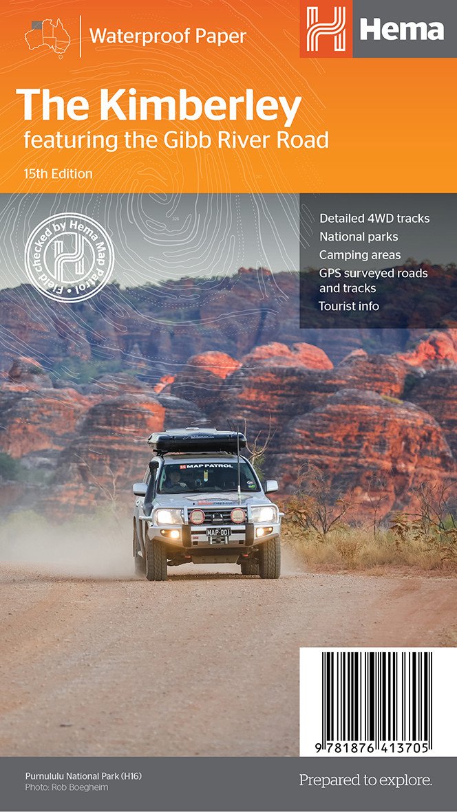
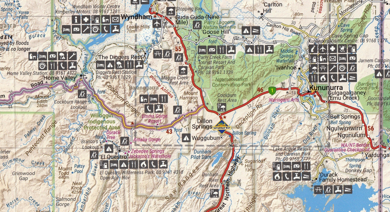
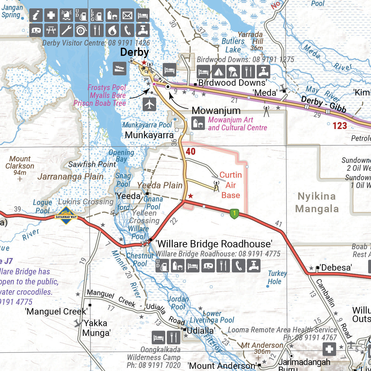
Kimberley Hema Map NEW 15th Edition
$14.95 $15.95
Afterpay is only available for orders between $50.00 and $1000.00 More info
A rugged, richly detailed guide to navigating one of Australia’s last great frontiers
The Kimberley region of Western Australia is a place of staggering beauty and scale—remote, untamed, and filled with natural wonders. From the gorges of Purnululu National Park to the ancient rock formations along the Gibb River Road, it’s a land that demands exploration—and preparation. The Hema Kimberley Map (15th Edition) is an essential travel tool for anyone setting out to discover this wild and captivating region.
Created by Hema’s Map Patrol team—who survey remote Australia in specially equipped 4WD vehicles—this map combines GPS-verified accuracy with up-to-date travel information, making it a trusted companion for caravanners, campers, tourers, and 4WD adventurers alike.
Map Specifications:
-
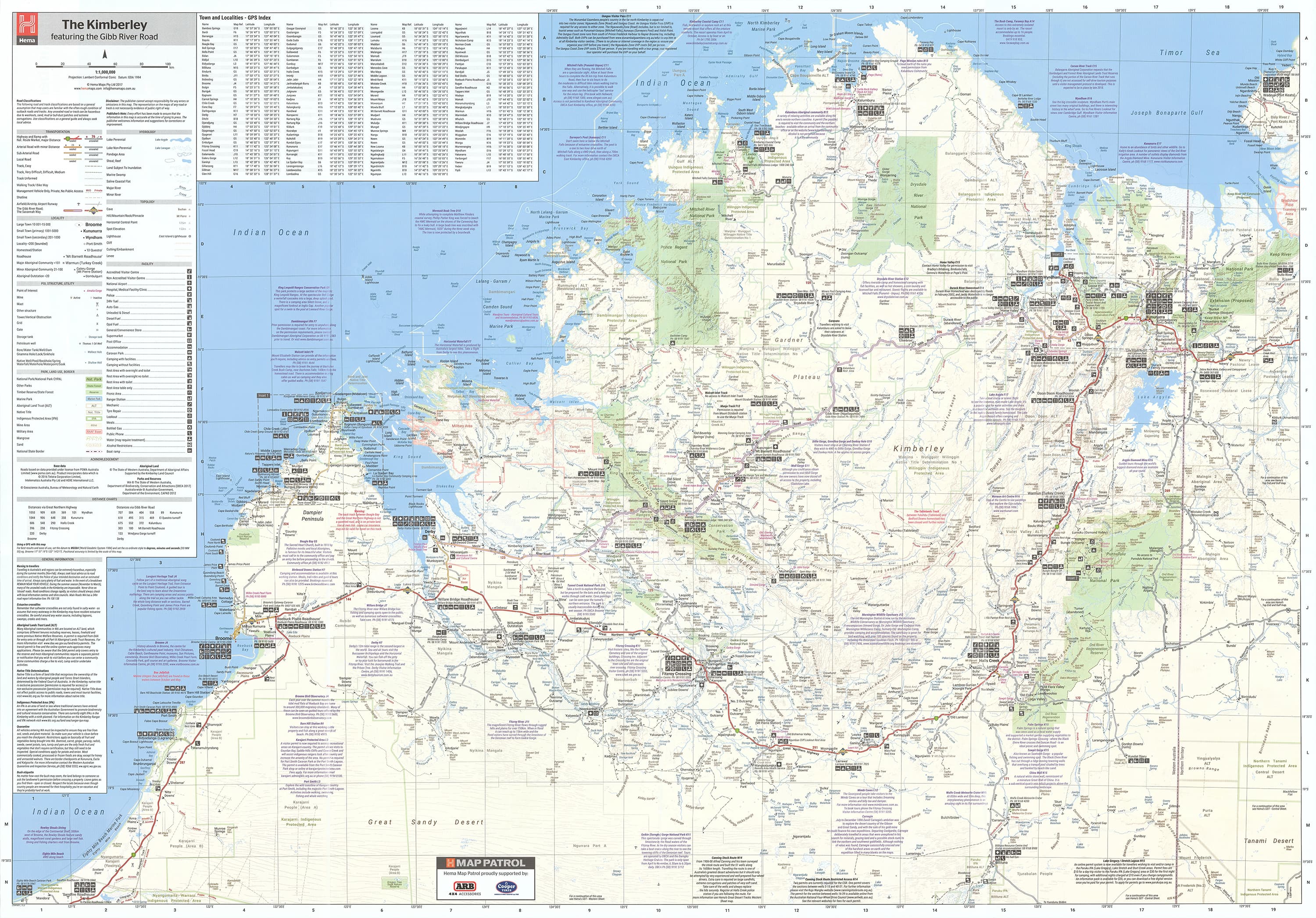
Scale: 1:1,100,000 (1 cm = 11 km)
Offers the right balance between overview and travel-ready detail -
Flat Size: 1000 mm (W) x 700 mm (H)
-
Folded Size: 250 mm x 140 mm
-
Weight: Approximately 90 grams
-
Edition: 15th Edition
-
Publication Date: 1 March 2017
-
Printed on: Waterproof and tear-resistant synthetic paper—built for outback use
Key Features:
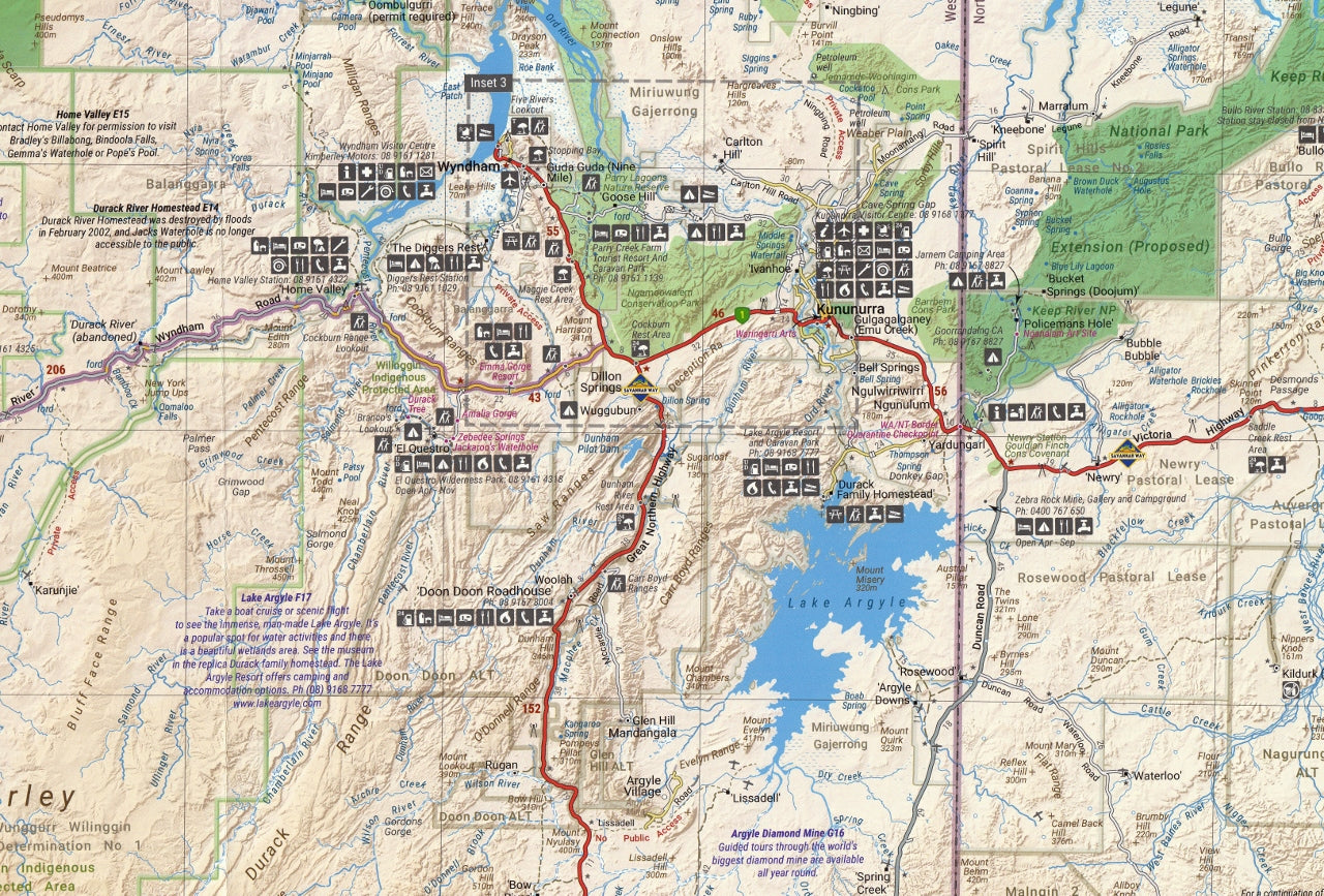
Extensive Road and Track Coverage:
-
GPS-surveyed roads, tracks, and remote access routes
-
Clearly marked sealed and unsealed roads
-
Driving distances and road conditions shown
-
Highlights iconic tracks like the Gibb River Road, Tanami Track, and Kalumburu Road
-
4WD tracks, access gates, river crossings, and seasonal closures noted
Touring & Travel Essentials:
-
Camping and overnight sites
-
24-hour fuel stops and roadhouses
-
Indigenous land permits and restricted access areas clearly marked
-
Information on remote accommodation options and supplies
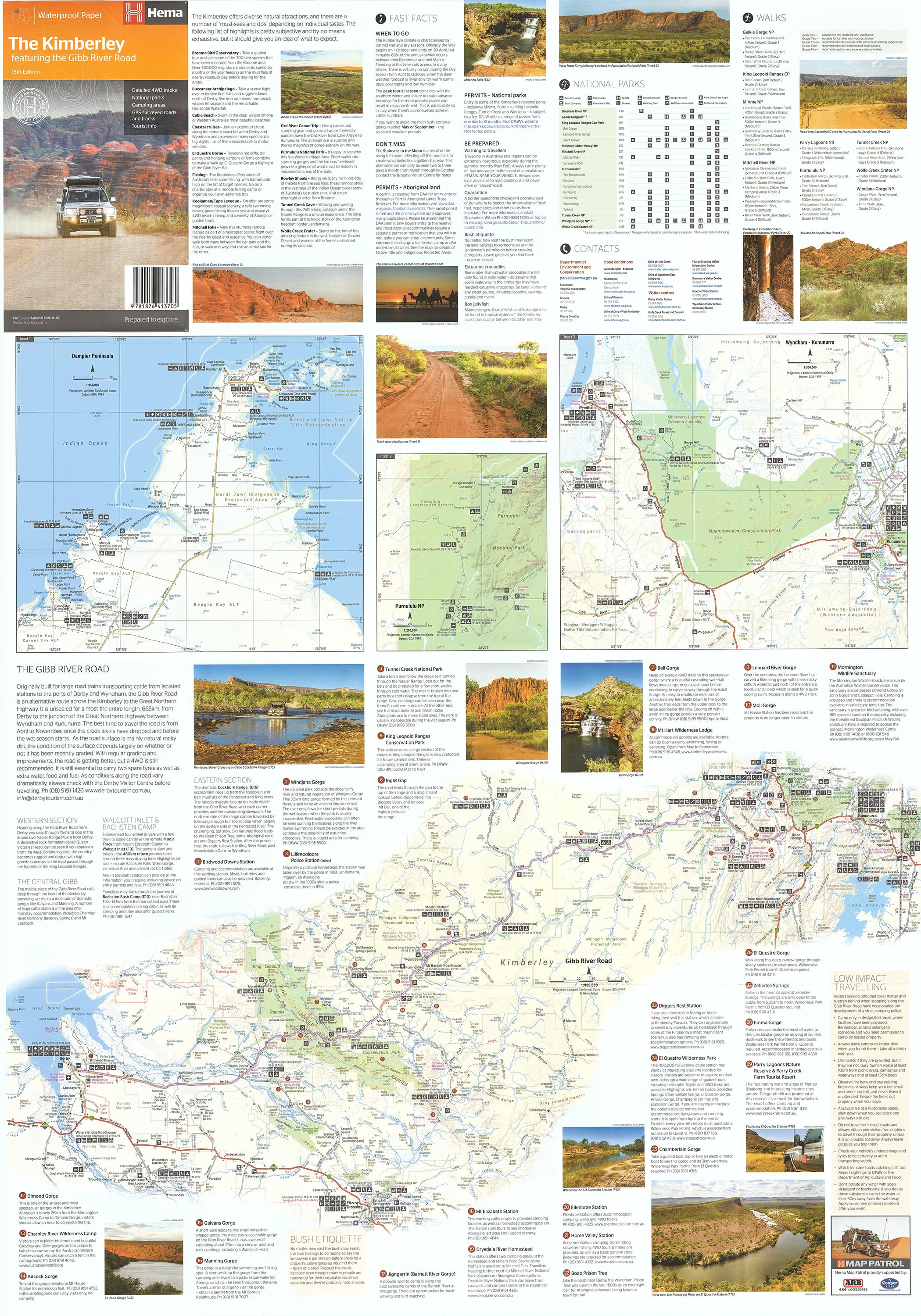
Inset Maps Include:
-
Purnululu National Park (Bungle Bungles) – detailed navigation within this World Heritage-listed park
-
Dampier Peninsula – showing Cape Leveque Road, beaches, and community areas
-
Parry Creek Area – a hotspot for birdwatchers and nature lovers
Natural Features:
-
National parks, reserves, and conservation zones
-
Rivers, gorges, waterfalls, and waterholes
-
Mountain ranges, escarpments, and geological formations
-
Coastal inlets and marine reserves
Tourist & Cultural Info:
-
Regional overviews and travel notes
-
Historical context of the Kimberley, including Indigenous culture
-
Practical travel advice for remote-area touring (weather, fuel range, supplies, communication)
-
Points of interest clearly marked: scenic lookouts, Aboriginal rock art, boat ramps, and more
Built for the Bush:
-
Printed on durable synthetic waterproof paper that won’t tear or fade
-
Foldable and lightweight—ideal for gloveboxes, backpacks, or 4WD dashboards
-
Perfect for use with erasable markers or Hema’s Mark-It-Dots for custom trip planning
Who Is This Map For?:
-
4WD explorers and overlanders tackling the Gibb or venturing to Mitchell Plateau
-
Grey nomads and caravaners on the journey of a lifetime
-
Adventure travellers seeking hikes, waterfalls, and remote campgrounds
-
Tour guides, educators, and researchers needing reliable regional data
-
Photographers and nature lovers in pursuit of the Kimberley’s hidden gems
The Kimberley is not a place to take lightly—it rewards the prepared and awes the adventurous. With its trusted detail, hardwearing build, and unmatched clarity, the Hema Kimberley Map is the ultimate guide to travelling safely, efficiently, and memorably in one of Australia's most majestic landscapes.
Unfold the journey. Discover the Kimberley. Travel with Hema.
Frequently Asked Questions
What does the Kimberley Hema Map NEW 15th Edition cover?
The Kimberley Hema Map NEW 15th Edition covers 4WD tracks, camping areas, and travel routes for the region described in the product title. Most 4WD and camping guides in Mapworld's range include GPS coordinates, distance information, difficulty ratings, and notes on fuel stops and emergency contact points.
Is the Kimberley Hema Map NEW 15th Edition up to date?
Yes, this is the current edition. Mapworld stocks current editions from publishers including Hema Maps, Westprint, and others.
Is this product suitable for remote area travel?
Yes, 4WD maps and guides are designed for remote area navigation and trip planning. They include track conditions, fuel availability, camping spots, and safety information.
Does Mapworld ship the Kimberley Hema Map NEW 15th Edition across Australia?
Yes, Mapworld ships Australia-wide. Standard shipping is a flat $7 rate, with free standard shipping on orders over $75. Express options are available at checkout. Most orders placed before 2pm AEST on weekdays are dispatched same day.
Related Items


© 2026 Mapworld. Website designed by Genie Media
X