- Australia ▾
- Topographic
▾
- Australia AUSTopo 250k (2025)
- Australia 50k Geoscience maps
- Australia 100k Geoscience maps
- Australia 250k Geoscience maps
- Australia 1:1m Geoscience maps
- New Zealand 50k maps
- New Zealand 250k maps
- New South Wales 25k maps
- New South Wales 50k maps
- New South Wales 100k maps
- Queensland 10k maps
- Queensland 25k maps
- Queensland 50k maps
- Queensland 100k maps
- Compasses
- Software
- GPS Systems
- Orienteering
- International ▾
- Wall Maps
▾
- World
- Australia & New Zealand
- Countries, Continents & Regions
- Historical
- Vintage National Geographic
- Australian Capital Territory
- New South Wales
- Northern Territory
- Queensland
- South Australia
- Tasmania
- Victoria
- Western Australia
- Celestial
- Children's
- Mining & Resources
- Wine Maps
- Healthcare
- Postcode Maps
- Electoral Maps
- Nautical ▾
- Flags
▾
- Australian Flag Sets & Banners
- Flag Bunting
- Handwavers
- Australian National Flags
- Aboriginal Flags
- Torres Strait Islander Flags
- International Flags
- Flagpoles & Accessories
- Australian Capital Territory Flags
- New South Wales Flags
- Northern Territory Flags
- Queensland Flags
- South Australia Flags
- Tasmania Flags
- Victoria Flags
- Western Australia Flags
- Gifts ▾
- Globes ▾
Dear valued customer. Please note that our checkout is not supported by old browsers. Please use a recent browser to access all checkout capabilities


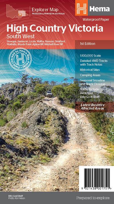
Victorian High Country SW 100K Hema Map
$15.95
Afterpay is only available for orders between $50.00 and $1000.00 More info
A meticulously detailed topographic and touring map designed for 4WD adventurers, hikers, and outdoor explorers tackling the iconic ranges of Victoria’s southern High Country.
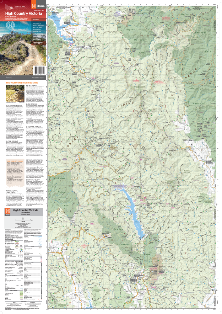
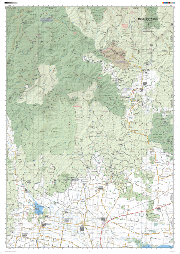
The Victorian High Country – South Western Map is part of Hema’s acclaimed High Country map series, created specifically for those exploring the challenging terrain, historic tracks, and remote wilderness of one of Australia’s most loved alpine regions. This map zeroes in on the southwest section of the Victorian Alps, offering large-scale topographic detail (1:100,000) and field-verified road and track information ideal for trip planning, safe travel, and immersive exploration.
🗺️ Map Specifications:
-
Scale: 1:100,000 — 1 cm = 1 km, offering fine-grain topographic clarity
-
Flat Size: 1000 mm (H) x 700 mm (W)
-
Folded Size: 250 mm x 140 mm x 3 mm
-
Weight: Approx. 90 grams
-
Edition: 1st
-
Published: 15 October 2020
-
Material: Printed on waterproof and tear-resistant synthetic paper — ideal for use in tough field conditions
-
Printed by: Hema Maps — Australia’s most trusted name in off-road navigation
🌄 Coverage Area:
Covers the southwestern portion of the Victorian High Country, including:
-
Baw Baw National Park
-
Dargo and surrounding Alpine regions
-
Swifts Creek, Lakes Entrance, Buchan, and Orbost
-
Wentworth State Forest, Tambo Crossing, Metung, and the Snowy River area
This region is known for its dense forests, rugged mountain tracks, alpine meadows, and historic gold-mining settlements, making it an adventurer’s playground and a photographer’s dream.
🧭 Key Features:
🚙 4WD and Touring Essentials:
-
Field-checked 4WD tracks and unsealed roads, many of which are seasonal or require high clearance
-
Route classifications based on difficulty
-
Distances between key waypoints and campsites
-
Highlighted iconic routes, remote access points, and crossings
🏕️ Camping & Outdoor Features:
-
Numerous free and paid campsites
-
Historic huts, ruins, and townsites — great for cultural and historical interest
-
Locations of picnic areas, fire pits, walking trails, and day-use areas
🗺️ Topographic Detail:
-
Contour lines at 50-metre intervals for elevation awareness
-
Clearly defined ridge lines, valleys, watercourses, peaks, and escarpments
-
Visual relief shading to enhance terrain comprehension
-
Marked gorges, rivers, waterfalls, alpine plateaus, and snow-affected areas
❄️ Seasonal Track Closures & Warnings:
-
Key alpine routes clearly marked as seasonally closed
-
Essential for avoiding inaccessible or unsafe conditions in winter and early spring
-
Includes emergency contact points and ranger information for track updates
⛽ Facilities and Logistics:
-
Locations of fuel stops, general stores, ranger stations, and emergency services
-
Contact details for visitor centres and land management authorities
-
Information on land tenure and access restrictions
🚩 Ideal For:
-
4WD enthusiasts planning multi-day adventures or challenging backcountry trips
-
Hikers and bushwalkers seeking quiet alpine trails and heritage sites
-
Campers, caravaners, and overlanders travelling through remote locations
-
Photographers and nature lovers chasing waterfalls, wildlife, and mountain views
-
Students, researchers, and educators needing physical geography resources
-
Tour guides and local operators crafting safe, scenic routes through Victoria’s remote south east
🔧 Why This Map Stands Out:
-
Part of Hema’s larger Victorian High Country Map Series, designed for complete coverage of the alpine region
-
Up-to-date field-verified information by the Hema Map Patrol
-
Tough, flexible material built to survive mud, rain, dust, and backpack wear
-
Compatible with GPS coordinates and digital route planners
-
Trusted by off-road adventurers, park rangers, and seasoned bush travellers across Australia
Whether you’re tracking along the Dargo High Plains, heading into the wilds of Errinundra, or tracing the banks of the Snowy River, the Hema Victorian High Country – South Western Map is your go-to tool for navigating terrain, uncovering hidden camps, and embracing the spirit of true Alpine adventure.
Push further. Stay safe. Discover more — with Hema by your side.
This map is also available as a laminated map encapsulated in high-quality plastic.
Frequently Asked Questions
What does the Victorian High Country SW 100K Hema Map cover?
The Victorian High Country SW 100K Hema Map covers 4WD tracks, camping areas, and travel routes for the region described in the product title. Most 4WD and camping guides in Mapworld's range include GPS coordinates, distance information, difficulty ratings, and notes on fuel stops and emergency contact points.
Is the Victorian High Country SW 100K Hema Map up to date?
Yes, this is the current edition. Mapworld stocks current editions from publishers including Hema Maps, Westprint, and others.
Is this product suitable for remote area travel?
Yes, 4WD maps and guides are designed for remote area navigation and trip planning. They include track conditions, fuel availability, camping spots, and safety information.
Does Mapworld ship the Victorian High Country SW 100K Hema Map across Australia?
Yes, Mapworld ships Australia-wide. Standard shipping is a flat $7 rate, with free standard shipping on orders over $75. Express options are available at checkout. Most orders placed before 2pm AEST on weekdays are dispatched same day.
Related Items


© 2026 Mapworld. Website designed by Genie Media
X