- Australia ▾
- Topographic
▾
- Australia AUSTopo 250k (2025)
- Australia 50k Geoscience maps
- Australia 100k Geoscience maps
- Australia 250k Geoscience maps
- Australia 1:1m Geoscience maps
- New Zealand 50k maps
- New Zealand 250k maps
- New South Wales 25k maps
- New South Wales 50k maps
- New South Wales 100k maps
- Queensland 10k maps
- Queensland 25k maps
- Queensland 50k maps
- Queensland 100k maps
- Western Australia 25k maps
- Western Australia 50k maps
- Western Australia 100k maps
- Compasses
- Software
- GPS Systems
- International ▾
- Wall Maps
▾
- World
- Australia & New Zealand
- Countries, Continents & Regions
- Historical
- Vintage National Geographic
- Australian Capital Territory
- New South Wales
- Northern Territory
- Queensland
- South Australia
- Tasmania
- Victoria
- Western Australia
- Celestial
- Children's
- Mining & Resources
- Wine Maps
- Healthcare
- Postcode Maps
- Electoral Maps
- Nautical ▾
- Flags
▾
- Australian Flag Sets & Banners
- Flag Bunting
- Handwavers
- Australian National Flags
- Aboriginal Flags
- Torres Strait Islander Flags
- International Flags
- Flagpoles & Accessories
- Australian Capital Territory Flags
- New South Wales Flags
- Northern Territory Flags
- Queensland Flags
- South Australia Flags
- Tasmania Flags
- Victoria Flags
- Western Australia Flags
- Gifts ▾
- Globes ▾
Dear valued customer. Please note that our checkout is not supported by old browsers. Please use a recent browser to access all checkout capabilities
Why Historical Maps Make Beautiful and Meaningful Wall Art

From Captain Cook’s voyages and the ANZAC campaign to pastoral station maps, Kokoda, Kosciusko, the Blue Mountains and vintage aviation, historical maps bring depth, memory and story to the wall.
Some wall art is chosen because it is beautiful.
Historical maps are chosen because they are beautiful and meaningful.
They do not simply fill a space.
They tell you something.
About a place.
About a journey.
About a coastline.
About a battlefield.
About a family region.
About a railway dream.
About a nation still being explored, surveyed, named and understood.
That is why historical maps remain some of the most compelling wall art you can own. They combine the elegance of cartography with the emotional pull of history. A historical map can be read from across the room as a striking decorative piece — then explored up close as a record of roads, rivers, boundaries, routes, settlements, stations, mountains, campaigns and voyages.
At Mapworld, the Historical Wall Maps collection brings together beautifully reproduced maps of Australia, the world, regions, campaigns, railways, exploration routes and culturally significant landscapes. The collection includes fine art paper, laminated and canvas options, making these maps suitable for homes, offices, classrooms, libraries, boardrooms and meaningful gifts.
The best-selling maps on the first page of the collection show exactly why historical maps have such broad appeal. They range from Norman Tindale’s 1940 Map of Aboriginal Tribal Boundaries and The Discovery and Exploration of Australia to H.E.C. Robinson pastoral station maps, ANZAC and Kokoda maps, Captain Cook’s Voyages, Kosciusko, Blue Mountains & Burragorang, Lake Macquarie, Hawkesbury River, vintage railway maps, aviation maps, and the wonderfully characterful Pictorial Wall Map of Melbourne by Dale.
Together, they show why historical maps are more than decoration.
They are history made visible.
Historical Maps Tell Stories Ordinary Art Cannot
A painting may capture a mood.
A photograph may capture a moment.
A historical map captures a way of understanding the world.
It shows how people once saw a country, a region, a route, a frontier, a campaign, a coastline or a landscape.
That is what makes historical maps so rewarding.
They reveal:
-
Old place names
-
Former boundaries
-
Pastoral holdings
-
Exploration routes
-
Military campaigns
-
Railway networks
-
Historic roads
-
Coastal and inland journeys
-
Cultural landscapes
-
Changing ideas of Australia
A historical map invites you to step closer.
At first, you see the whole design.
Then you notice a region.
Then a route.
Then a name.
Then a river, mountain, station, town, battlefield or coastline that connects the map to something personal.
That slow discovery is what makes historical map wall art so satisfying.
Norman Tindale’s 1940 Map of Aboriginal Tribal Boundaries
One of the most significant maps in Mapworld’s Historical Wall Maps collection is Norman Tindale’s 1940 Map of Aboriginal Tribal Boundaries.
This is not simply a decorative map.
It is a historically important representation of Aboriginal tribal and cultural regions across Australia, based on the research and classification systems of its time.

Displayed thoughtfully, it can support important conversations about:
-
Country
-
language
-
cultural geography
-
Indigenous history
-
colonisation
-
historical mapping
-
the limits of Western cartography
-
the diversity of Aboriginal Australia
It is especially suitable for:
-
schools
-
universities
-
libraries
-
cultural education spaces
-
reconciliation displays
-
research offices
-
historical collections
This map should be approached respectfully. No single historical map can fully capture the complexity, depth and continuity of Aboriginal connection to Country. Boundaries may be approximate, overlapping or contested, and local Traditional Owner knowledge should always be respected.
But as a historical map, Tindale’s 1940 work remains powerful.
It asks viewers to think deeply about land, culture, language, representation and history.
The Discovery and Exploration of Australia, 1519 to 1901
Few historical wall maps tell a broader national story than The Discovery and Exploration of Australia, 1519 to 1901 by Sea and Land.
This map is ideal for people who love exploration history.
It brings together the layered story of how Australia was gradually charted, crossed, surveyed and understood by European explorers.

It speaks to:
-
early maritime encounters
-
inland expeditions
-
coastal exploration
-
overland journeys
-
colonial expansion
-
the mapping of a continent
As wall art, it works beautifully because it has both scale and narrative.
You can trace movement across the page.
Voyages.
Journeys.
Routes.
Names.
Dates.
It is particularly suited to:
-
classrooms
-
libraries
-
studies
-
history departments
-
boardrooms
-
home offices
-
collectors of Australian exploration history
This is a map for anyone who wants Australian history on the wall in a way that feels both educational and visually rich.
Captain Cook’s Voyages World Wall Map Published 1801
Captain Cook’s Voyages World Wall Map Published 1801 is one of the most evocative pieces in the collection.
Cook’s voyages belong to the great age of Pacific exploration. This map places those routes into a global context, showing the movement of ships across oceans and the widening European knowledge of the Pacific world.
For Australian viewers, Cook’s 1770 charting of the east coast carries particular significance.
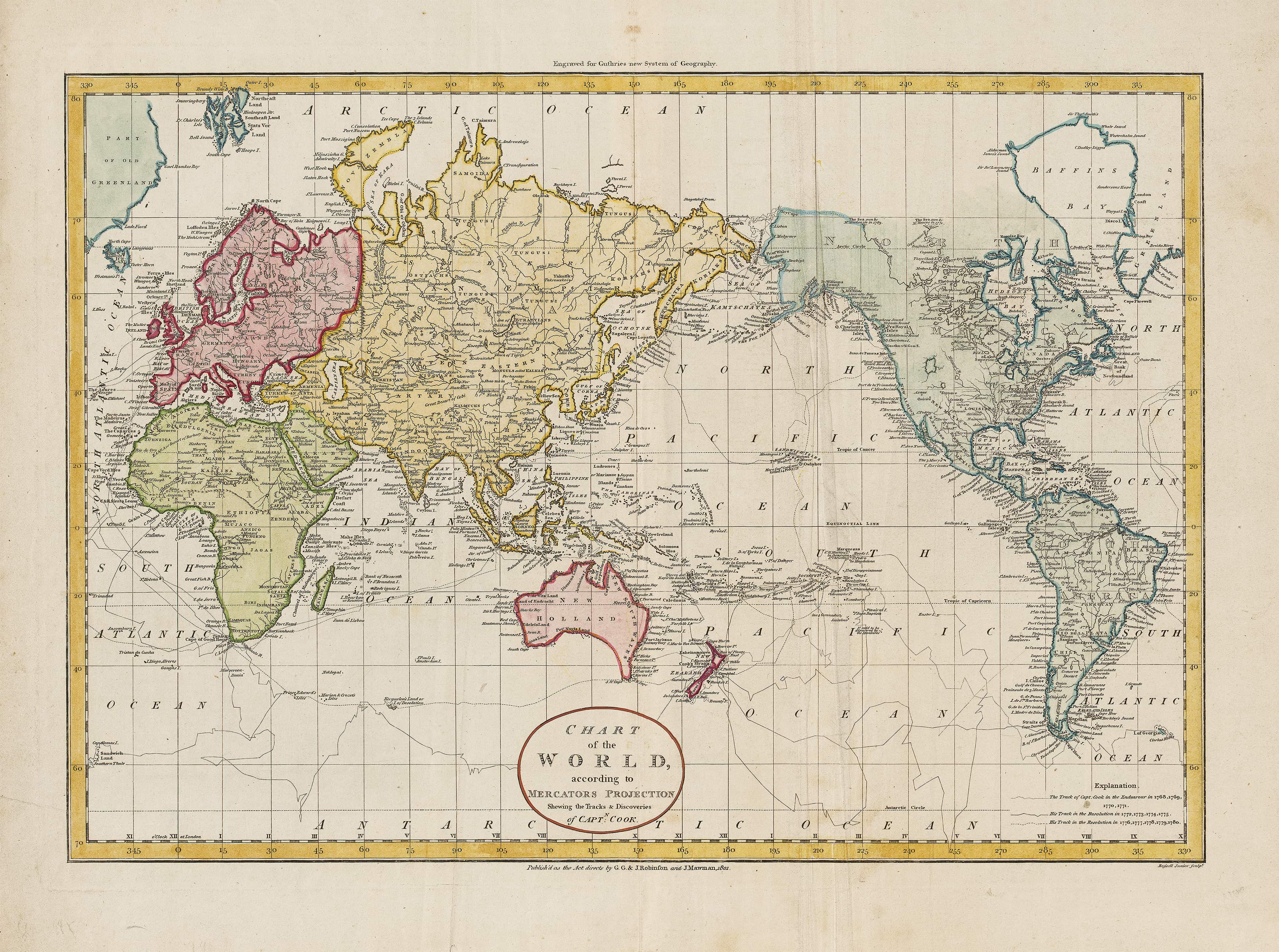
The map connects Australia to a much wider story of:
-
navigation
-
empire
-
scientific observation
-
Pacific exploration
-
maritime risk
-
cartographic change
It is an exceptional choice for:
-
maritime enthusiasts
-
naval historians
-
schools
-
libraries
-
coastal homes
-
studies
-
collectors
-
offices with a global or historical focus
A Cook voyage map has immediate visual drama. It is not static. It moves. The eye follows the routes across the oceans, through the Pacific, around Australia and beyond.
It is wall art with momentum.
H.E.C. Robinson Pastoral Station Maps
Among the most popular historical maps in the collection are the H.E.C. Robinson pastoral station maps, including:
These maps are powerful because they connect directly to rural Australia.
They show the geography of pastoral landholding — station names, regions, boundaries, towns and inland patterns of settlement and production.

For many families, these maps are deeply personal.
A station name might connect to a grandparent.
A district might recall childhood.
A region might represent work, land, memory or identity.
That makes pastoral station maps ideal for:
-
rural homes
-
farm offices
-
station homesteads
-
agricultural businesses
-
regional boardrooms
-
country pubs
-
heritage accommodation
-
family history displays
-
schools and agricultural colleges
They are beautiful in the way practical maps often are: precise, information-rich, purposeful and quietly authoritative.
A pastoral station map on the wall does not merely say “Australia”.
It says country, land, work, memory and belonging.
ANZAC Wall Map by Robinson, Published 1916
The ANZAC Wall Map by Robinson, published 1916, carries a very different emotional weight.
This is a map connected to one of the defining stories of Australian national memory.
ANZAC maps speak to:
-
wartime geography
-
military history
-
sacrifice
-
national identity
-
commemoration
-
education
As wall art, an ANZAC map is not chosen casually.

It belongs in places where history is honoured and discussed.
It is particularly suited to:
-
schools
-
RSL clubs
-
military history collections
-
libraries
-
studies
-
museums
-
heritage displays
-
family homes with military connections
A historical war map has a solemn quality. It is not just decorative. It asks us to remember where events happened and how geography shaped the campaign.
For classrooms and libraries, it offers a strong visual way to discuss Australia’s First World War history.
Kokoda Trail Wall Map
The Kokoda Trail Wall Map is another historically powerful piece.
Kokoda occupies a profound place in Australian memory. It represents endurance, terrain, difficulty, courage and the brutal reality of war in jungle country.
A Kokoda map gives shape to a story many Australians know emotionally but may not understand geographically.

It helps viewers see:
-
the route
-
the terrain
-
the relationship between places
-
the physical challenge
-
the strategic importance of geography
This map is ideal for:
-
schools
-
military history enthusiasts
-
RSL and veteran spaces
-
libraries
-
studies
-
adventure and trekking communities
-
commemorative displays
Kokoda is a reminder that maps are not just about where things are.
They are about what happened there.
Vintage Railway Wall Map of Australia, Published 1935
The Vintage Railway Wall Map of Australia published 1935 is one of those historical maps that immediately sparks curiosity.
Railway maps show Australia through connection.
Tracks.
Lines.
Termini.
Ports.
Inland towns.
Distances.
Ambitions.
By 1935, railways had become one of the great forces shaping Australian settlement, freight, industry and regional life.

A vintage railway map works beautifully as wall art because it combines technical detail with nostalgia.
It is perfect for:
-
railway enthusiasts
-
transport offices
-
logistics businesses
-
studies
-
libraries
-
regional homes
-
history classrooms
-
boardrooms
-
collectors of industrial heritage
Railway maps remind us that Australia was not only explored by ship, horse, camel and foot.
It was also stitched together by rail.
Vintage Aviation Wall Map of Australia 1948
The Vintage Aviation Wall Map of Australia 1948 captures another great era of Australian connection.
Where railway maps show the country joined by track, aviation maps show it joined by air.
By the late 1940s, aviation was transforming distance. Towns, cities and remote places were being connected in ways that would have seemed extraordinary only decades earlier.
This map is ideal for:
-
aviation enthusiasts
-
pilots
-
travel offices
-
executive offices
-
studies
-
libraries
-
classrooms
-
transport and logistics businesses
As wall art, it has a wonderful post-war energy.
It speaks of movement, progress, technology and the shrinking of distance across a vast continent.

Displayed beside a vintage railway map, it tells an even stronger story: Australia connected first by land routes, then by air.
Hawkesbury River Wall Map 1953
The Hawkesbury River Wall Map 1953 is a beautiful choice for people with a connection to one of New South Wales’ most distinctive waterways.
The Hawkesbury is not merely a river.
It is a landscape of sandstone, settlement, agriculture, boating, bridges, ferries, towns, fishing, holiday houses and deep local identity.
A historical Hawkesbury River map works particularly well in:
-
river homes
-
coastal and estuary interiors
-
Sydney and NSW studies
-
local history displays
-
holiday houses
-
schools
-
libraries
-
cafés and accommodation spaces
Maps of rivers have a special appeal.
They follow a natural line through the land.
They invite the viewer to travel along the waterway, bend by bend, place by place.
For anyone connected to the Hawkesbury, this map is both decorative and personal.
Lake Macquarie Wall Map 1935
The Lake Macquarie Wall Map 1935 has a similarly strong local appeal.
Lake Macquarie is one of Australia’s great coastal lake landscapes — a place of boating, fishing, suburbs, bushland, beaches and family holidays.
A 1935 wall map shows the lake in another era.
That is the pleasure of historical local maps.
They let people compare memory with map.
What was named?
What was developed?
What was still open land?
Which roads existed?
Which suburbs had begun to take shape?

The Lake Macquarie map is ideal for:
-
local homes
-
coastal interiors
-
holiday houses
-
real estate offices
-
council spaces
-
schools
-
libraries
-
local history lovers
A historical local map is often one of the most personal forms of wall art you can choose.
Kosciusko Historical Wall Map 1945
The Kosciusko Historical Wall Map 1945 is a superb piece for anyone drawn to the Australian Alps.
Kosciusko is a landscape of mountains, snow country, alpine huts, walking routes, rivers, high plains and national memory.
A 1945 historical map of the region carries a wonderful sense of place.

It suits:
-
mountain homes
-
ski lodges
-
bushwalking clubs
-
outdoor education centres
-
studies
-
schools
-
alpine accommodation
-
national park enthusiasts
This is the sort of map that appeals to people who know the region not just as a destination, but as a landscape.
For walkers, skiers, climbers and alpine travellers, a historical Kosciusko map can feel like a tribute to the country itself.
Blue Mountains & Burragorang Wall Map 1939
The Blue Mountains & Burragorang Wall Map 1939 is another standout local and regional piece.
The Blue Mountains are among Australia’s most loved landscapes: escarpments, valleys, sandstone cliffs, waterfalls, lookouts, walking tracks, villages and deep bushland.
Burragorang adds another layer of historical resonance, especially because the valley’s story is connected to water, settlement and change.

A 1939 map of this region is ideal for:
-
Blue Mountains homes
-
bushwalkers
-
historians
-
libraries
-
schools
-
guest houses
-
national park lovers
-
Sydney-region collectors
As wall art, it offers both beauty and nostalgia.
People who know the Blue Mountains will naturally search the map for familiar names and places.
That is one of the great joys of historical regional maps.
They turn memory into geography.
Pictorial Wall Map of Melbourne by Dale, Published 1934
The Pictorial Wall Map of Melbourne by Dale published 1934 brings a completely different energy to the collection.
Pictorial maps are lively, characterful and full of personality.
Rather than presenting geography in a strictly technical way, they often combine map form with illustration, humour, landmark detail and civic pride.

A pictorial Melbourne map is perfect for:
-
Melbourne homes
-
apartments
-
creative offices
-
cafés
-
design studios
-
libraries
-
schools
-
gifts for Melbourne lovers
-
gallery walls
It is historical, but also playful.
It captures Melbourne not just as streets and suburbs, but as a city with identity and charm.
For wall art, pictorial maps are especially effective because they reward both quick viewing and close inspection.
They are maps made to be enjoyed.
Gleason’s New Standard Flat Earth Map of the World
Among the more unusual best-selling pieces is Gleason’s New Standard Flat Earth Map of the World.
This map is historically fascinating because it reflects a very particular cartographic and cultural idea. It is not purchased as a modern geographic reference, but as a curiosity, conversation piece and example of historical map design.

Displayed correctly, it is ideal for:
-
collectors
-
classrooms discussing map projections
-
libraries
-
studies
-
conversation walls
-
people interested in unusual historical maps
It can be used to ask important questions:
-
How do map projections shape perception?
-
Why have people represented the world differently?
-
What makes a map persuasive?
-
How do design and belief intersect?
As wall art, it certainly starts conversations.
Why These Best Sellers Work So Well Together
The first-page best sellers in Mapworld’s Historical Wall Maps collection are powerful because they cover so many forms of history.
They include:
-
Aboriginal cultural mapping
-
European exploration
-
Captain Cook’s voyages
-
pastoral Australia
-
ANZAC history
-
Kokoda
-
railway development
-
aviation history
-
river and lake regions
-
alpine landscapes
-
Blue Mountains heritage
-
Melbourne civic identity
-
unusual world mapping
This breadth makes the collection ideal for different customers.
A rural family may choose a pastoral station map.
A teacher may choose the Discovery and Exploration map.
A military history enthusiast may choose ANZAC or Kokoda.
A pilot may choose the Vintage Aviation Wall Map.
A Sydney family may choose Hawkesbury River, Lake Macquarie or Blue Mountains & Burragorang.
A Melbourne customer may choose Dale’s pictorial map.
A collector may choose Captain Cook or Gleason’s Flat Earth map.
The collection works because historical maps are personal.
People choose the map that connects to their story.
Choosing Historical Maps by Interest
For Australian Exploration
Choose:
-
The Discovery and Exploration of Australia, 1519 to 1901
-
Captain Cook’s Voyages World Wall Map Published 1801
These maps tell the story of journeys, coastlines, routes and exploration.
For Rural and Station History
Choose:
-
New South Wales Pastoral Stations 1919
-
Queensland Pastoral Stations 1920
-
South Australia Pastoral Stations 1948
These are ideal for rural homes, agricultural businesses and family history.
For Military History
Choose:
-
ANZAC Wall Map by Robinson published 1916
-
Kokoda Trail Wall Map
These are strong educational and commemorative pieces.
For Transport History
Choose:
-
Vintage Railway Wall Map of Australia published 1935
-
Vintage Aviation Wall Map of Australia 1948
These celebrate the systems that connected a vast continent.
For Regional NSW
Choose:
-
Hawkesbury River Wall Map 1953
-
Lake Macquarie Wall Map 1935
-
Kosciusko Historical Wall Map 1945
-
Blue Mountains & Burragorang Wall Map 1939
These are perfect for place-based wall art.
For Melbourne
Choose:
-
Pictorial Wall Map of Melbourne by Dale published 1934
A characterful and highly decorative choice.
For Cultural and Educational Context
Choose:
-
Norman Tindale’s 1940 Map of Aboriginal Tribal Boundaries
-
Gleason’s New Standard Flat Earth Map of the World
These maps invite deeper discussion about representation, belief, identity and cartography.
Paper, Laminated or Canvas?
Mapworld’s Historical Wall Maps collection offers finishes to suit different spaces and uses.
Fine Art Paper
Best for:
-
framing
-
studies
-
libraries
-
formal rooms
-
collector-style display
-
traditional interiors
Fine art paper provides a refined finish ideal for professional framing under glass or acrylic.
Laminated
Best for:
-
classrooms
-
libraries
-
offices
-
educational use
-
hands-on reference
-
high-traffic areas
Laminated maps are durable and practical. They suit maps that will be used, handled or displayed in busy environments.
Canvas
Best for:
-
living rooms
-
boardrooms
-
feature walls
-
gifts
-
heritage interiors
-
premium display
Canvas gives historical maps warmth, texture and presence. It turns the map into a gallery-style artwork.
Timber Hang Rails
Selected maps are also well suited to hang-rail presentation, especially larger maps where traditional framing may be expensive or impractical.
Hang rails offer:
-
easy hanging
-
clean presentation
-
relaxed heritage style
-
strong visual impact
-
practical display for large maps
Historical Maps for Homes
In a home, a historical map does something few artworks can.
It gives the room a sense of story.
A pastoral station map in a country home.
A Hawkesbury River map in a riverside house.
A Blue Mountains map in a mountain cottage.
A Captain Cook map in a study.
A Melbourne pictorial map in an apartment.
A Kosciusko map in a ski lodge.
Each one says something about the person who chose it.
Historical maps are ideal for:
-
living rooms
-
hallways
-
studies
-
libraries
-
bedrooms
-
home offices
-
guest rooms
-
holiday houses
-
family history walls
They make a home feel considered.
Not decorated at random, but connected to place.
Historical Maps for Offices and Boardrooms
Historical maps also work beautifully in professional settings.
They bring authority, heritage and visual interest without feeling generic.
They are especially effective in:
-
law firms
-
architectural offices
-
planning firms
-
survey offices
-
agricultural businesses
-
regional councils
-
schools
-
universities
-
museums
-
tourism businesses
-
heritage consultants
-
boardrooms
A large historical map in an office suggests depth.
It says the organisation understands place, history and context.
For regional businesses, a local historical map can be particularly powerful.
It links the company to the community and landscape it serves.
Historical Maps as Gifts
Historical maps make memorable gifts because they can be chosen with precision.
A gift map might connect to:
-
a hometown
-
a family property
-
a favourite region
-
a military interest
-
a railway passion
-
aviation history
-
an exploration story
-
a holiday place
-
a family migration story
-
a collector’s interest
That makes them ideal for:
-
birthdays
-
retirements
-
Father’s Day
-
Christmas
-
housewarmings
-
corporate gifts
-
teacher gifts
-
family history gifts
-
milestone celebrations
A historical map feels thoughtful because it is rarely generic.
It says: I chose this because it means something.
Creating a Historical Map Gallery Wall
Historical maps work beautifully in groups.
You might build a gallery wall around a theme.
Australian Exploration Wall
Combine Captain Cook’s Voyages with The Discovery and Exploration of Australia.
Rural Heritage Wall
Group NSW, Queensland and South Australia pastoral station maps.
Wartime History Wall
Pair ANZAC with Kokoda.
Transport History Wall
Display the Vintage Railway Wall Map with the Vintage Aviation Wall Map.
Regional NSW Wall
Combine Hawkesbury River, Lake Macquarie, Kosciusko and Blue Mountains & Burragorang.
Melbourne Character Wall
Make Dale’s Pictorial Wall Map of Melbourne the centrepiece.
A strong gallery wall is not just a group of prints.
It is a story told across several maps.
Final Thoughts
Historical maps make beautiful wall art because they have line, form, colour, texture and vintage character.
They make meaningful wall art because they carry history.
They show where people travelled.
Where they fought.
Where they settled.
Where they built railways.
Where they flew.
Where they grazed stock.
Where they climbed mountains.
Where they mapped rivers, lakes, valleys and coastlines.
They show Australia not as a single fixed image, but as a place continually explored, connected, named, remembered and reinterpreted.
That is why Mapworld’s best-selling historical wall maps have such lasting appeal.
They are not simply old maps.
They are stories for the wall.
Stories of Country.
Stories of exploration.
Stories of war.
Stories of rural life.
Stories of movement.
Stories of home.
And in a world full of disposable decoration, that kind of meaning matters.
Frequently Asked Questions
Why do historical maps make good wall art?
Historical maps combine visual beauty with story, place and memory. They are decorative, but they also reveal how regions, routes, landscapes and nations were once understood.
What are some of Mapworld’s best-selling historical wall maps?
Popular first-page maps include Norman Tindale’s 1940 Map of Aboriginal Tribal Boundaries, The Discovery and Exploration of Australia, H.E.C. Robinson pastoral station maps, ANZAC Wall Map, Kokoda Trail Wall Map, Captain Cook’s Voyages, Vintage Railway Wall Map of Australia, Hawkesbury River, Lake Macquarie, Kosciusko, Blue Mountains & Burragorang, Pictorial Wall Map of Melbourne and Vintage Aviation Wall Map of Australia.
Which historical maps are best for rural homes?
The H.E.C. Robinson pastoral station maps are especially suited to rural homes, station properties, agricultural businesses and family history displays.
Which historical maps are best for schools?
The Discovery and Exploration of Australia, ANZAC Wall Map, Kokoda Trail Wall Map, Norman Tindale’s 1940 Map of Aboriginal Tribal Boundaries and Captain Cook’s Voyages are strong educational choices.
Which historical maps are best for NSW homes?
Hawkesbury River Wall Map 1953, Lake Macquarie Wall Map 1935, Kosciusko Historical Wall Map 1945, Blue Mountains & Burragorang Wall Map 1939 and New South Wales Pastoral Stations 1919 are excellent NSW-focused options.
Which historical map is best for Melbourne?
The Pictorial Wall Map of Melbourne by Dale published 1934 is one of the most characterful Melbourne historical wall maps in the collection.
Should I choose paper, laminated or canvas?
Choose fine art paper for framing, laminated for classrooms and high-use spaces, and canvas for a premium wall-art finish.
Are historical maps good gifts?
Yes. Historical maps make excellent gifts because they can be chosen to match a person’s home region, family history, profession, interest or favourite place.

Leave a comment
Comments will be approved before showing up.
Also in Map Guides, Travel Tips & Reviews

Best Maps for the Bibbulmun Track
The Bibbulmun Track is a journey through towering forests, quiet valleys, wildflower country and the rugged southern coast, unfolding across nearly 1,000 kilometres of Western Australia. No single map can reveal it all. A complete mapping kit may combine the official 1:50,000 map for the section underfoot, northern or southern map packs for longer walks, broader South West mapping for road access and resupply, and a wall map to understand how the entire journey from Kalamunda to Albany comes together.

Best Maps for Kosciuszko National Park
Kosciuszko National Park is a landscape of high ridges, alpine plains, deep valleys and long distances, where the right map can transform how the country is understood. No single map can reveal it all. A complete mapping kit may combine detailed 1:25,000 topographic sheets, a 1:50,000 alpine map, broader 1:100,000 coverage, and a touring or wall map to show how the Main Range, Jagungal, Kiandra, Jindabyne and the wider Snowy Mountains connect as one remarkable alpine landscape.

Best Maps for Vietnam
Vietnam is a country of extraordinary length and contrast, where mountain roads descend towards fertile river deltas, ancient cities give way to modern skylines, and the coastline stretches for thousands of kilometres along the South China Sea.
© 2026 Mapworld. Website designed by Genie Media
X
Christopher O'Keeffe
Author