- Australia ▾
- Topographic
▾
- Australia AUSTopo 250k (2025)
- Australia 50k Geoscience maps
- Australia 100k Geoscience maps
- Australia 250k Geoscience maps
- Australia 1:1m Geoscience maps
- New Zealand 50k maps
- New Zealand 250k maps
- New South Wales 25k maps
- New South Wales 50k maps
- New South Wales 100k maps
- Queensland 10k maps
- Queensland 25k maps
- Queensland 50k maps
- Queensland 100k maps
- Western Australia 25k maps
- Western Australia 50k maps
- Western Australia 100k maps
- Compasses
- Software
- GPS Systems
- International ▾
- Wall Maps
▾
- World
- Australia & New Zealand
- Countries, Continents & Regions
- Historical
- Vintage National Geographic
- Australian Capital Territory
- New South Wales
- Northern Territory
- Queensland
- South Australia
- Tasmania
- Victoria
- Western Australia
- Celestial
- Children's
- Mining & Resources
- Wine Maps
- Healthcare
- Postcode Maps
- Electoral Maps
- Nautical ▾
- Flags
▾
- Australian Flag Sets & Banners
- Flag Bunting
- Handwavers
- Australian National Flags
- Aboriginal Flags
- Torres Strait Islander Flags
- International Flags
- Flagpoles & Accessories
- Australian Capital Territory Flags
- New South Wales Flags
- Northern Territory Flags
- Queensland Flags
- South Australia Flags
- Tasmania Flags
- Victoria Flags
- Western Australia Flags
- Gifts ▾
- Globes ▾
Dear valued customer. Please note that our checkout is not supported by old browsers. Please use a recent browser to access all checkout capabilities
Health Network Maps Explained

How hospital, health-service and Primary Health Network wall maps help planners, clinicians, educators, government teams and service providers see Australia’s healthcare geography clearly.
Healthcare is deeply geographic.
Hospitals are not distributed randomly.
Primary Health Networks cover defined regions.
Rural health services must operate across distance.
Emergency facilities need to be understood in relation to roads, towns, catchments and population centres.
Public and private hospitals often cluster around major cities, while country health services must support vast areas with fewer facilities.
That is why health network maps matter.
They turn complex healthcare systems into something visible.
A spreadsheet may list hospitals.
A database may store addresses.
A website may describe service regions.
But a wall map lets everyone see the network at once.
At Mapworld, the Healthcare Maps collection brings together wall maps designed for healthcare organisations, government departments, emergency services, education providers, planners, public health teams, regional service organisations and professional offices. The collection includes hospital maps, Primary Health Network maps, metropolitan health maps, rural hospital maps, country health service maps and national health network wall maps.
These are not decorative maps in the ordinary sense.
They are practical tools for understanding healthcare infrastructure, access and service delivery across Australia.
What Is a Health Network Map?
A health network map is a wall map that shows the geography of healthcare services, facilities or administrative health regions.
Depending on the map, it may show:
-
Public hospitals
-
Private hospitals
-
Regional medical centres
-
Health precincts
-
Emergency facilities
-
Rural hospitals
-
Country health services
-
Primary Health Network boundaries
-
Metropolitan health regions
-
Statewide health-service coverage
-
National health network structure
Health network maps help users understand not just where healthcare facilities are, but how they relate to each other across space.
This is especially important in Australia, where distance, remoteness and regional variation strongly affect healthcare access.
Why Health Network Maps Matter
Healthcare planning is not only about services.
It is about location.
Where are the hospitals?
Where are the gaps?
Which communities are remote?
How far is the nearest regional centre?
Which Primary Health Network covers this area?
Where do public and private hospitals cluster?
Which facilities support rural communities?
How do health services relate to transport corridors, regional towns and metropolitan growth?
A good wall map helps answer these questions quickly.
Health network maps are valuable because they provide:
-
Clear spatial context
-
At-a-glance facility awareness
-
Better planning visibility
-
Shared reference during meetings
-
Support for service-delivery discussions
-
Education and training value
-
Regional and metropolitan comparison
-
Public health and emergency planning support
In a boardroom, office or classroom, a health map creates a shared picture of the system.
Everyone can point to the same places.
Everyone can see the same boundaries.
That shared understanding is the map’s real power.
Who Uses Health Network Maps?
Mapworld’s Healthcare Maps collection is useful across many sectors.
Government Departments
For policy, regional planning, infrastructure awareness, health-service coordination and public administration.
Hospitals and Health Services
For internal planning, catchment awareness, service-network display and staff orientation.
Primary Health Networks
For understanding PHN regions, stakeholder geography, outreach planning and community health coordination.
Emergency Services
For facility awareness, regional response planning, transport corridors and emergency-service coordination.
Universities and Training Providers
For teaching healthcare geography, public health, regional access, health policy and service distribution.
Aged Care and Community Health Providers
For planning outreach, referral pathways, regional coverage and service delivery.
Medical Suppliers and Business Teams
For sales territories, hospital networks, logistics and market planning.
Schools and Libraries
For educational display and health-infrastructure awareness.
Health network maps are particularly useful wherever healthcare, geography and decision-making overlap.
Australian Hospital Wall Maps: Seeing the National Health Landscape
Australian hospital wall maps provide a practical overview of the country’s healthcare infrastructure.
They can help users understand:
-
Where hospitals are concentrated
-
Which regions have major medical centres
-
How metropolitan and regional facilities compare
-
Where emergency facilities sit in relation to population centres
-
How public and private hospital networks differ
-
How state and territory systems fit into the national picture
A national health map is especially useful for organisations working across multiple states.
It suits:
-
national healthcare organisations
-
government departments
-
medical suppliers
-
pharmaceutical and health-sector businesses
-
education providers
-
logistics teams
-
aged care groups
-
public health planners
For national planning, a wall map offers something digital systems often hide: the scale of Australia and the distance between health services.
That perspective matters.
Australia Primary Health Care Network Wall Map
The Australia Primary Health Care Network Wall Map is one of the strongest national reference maps in Mapworld’s Healthcare collection.

Primary Health Networks, often known as PHNs, are central to Australia’s primary healthcare planning. They help coordinate primary health services, identify local health needs and support better integration between general practice, community health and wider healthcare systems.
A national PHN wall map is ideal for:
-
health departments
-
PHN offices
-
universities
-
public health teams
-
aged care organisations
-
mental health service providers
-
community health organisations
-
policy teams
-
healthcare consultants
-
boardrooms and training rooms
It helps show Australia’s primary healthcare geography at a glance.
Rather than reading a list of PHN names, users can see how regions sit across the country.
This is especially useful when discussing national programs, regional differences, service gaps, rural health, funding models or public health initiatives.
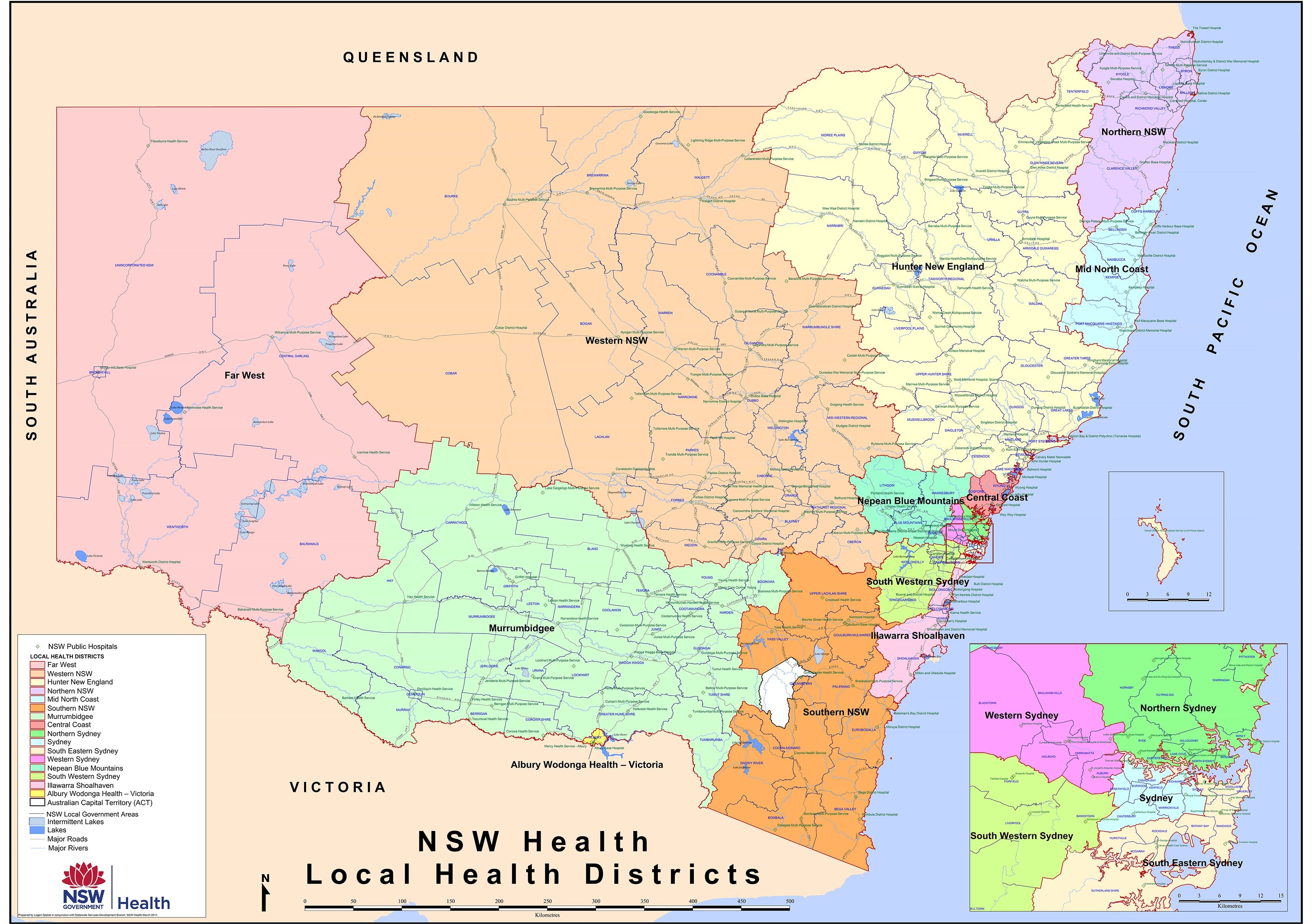
New South Wales Health & Hospitals Map
The New South Wales Health & Hospitals Map 1190 × 870 mm Wall Map is a strong choice for organisations focused on NSW healthcare infrastructure.
New South Wales has a complex healthcare landscape, with major metropolitan hospital networks in Sydney, regional hospitals across the state, and rural facilities serving large areas.
A NSW health and hospitals wall map is useful for:
-
hospitals
-
NSW government teams
-
public health planners
-
regional health services
-
universities
-
ambulance and emergency planning
-
health-sector businesses
-
aged care and community service organisations
It helps users understand how healthcare facilities relate to Sydney, regional centres, coastal corridors, inland towns and rural communities.
For NSW organisations, it provides practical state-level context that a national map cannot.
NSW Primary Health Network Maps
Mapworld’s Healthcare collection includes several NSW-focused Primary Health Network wall maps, including:
These maps are particularly valuable because NSW has both dense metropolitan healthcare regions and vast rural and regional service areas.
A metropolitan PHN map is ideal for understanding Sydney and surrounding urban health-service boundaries.
A statewide PHN map is better for broader policy, regional planning and service-delivery analysis.
NSW PHN maps are useful for:
-
PHN staff
-
GPs and primary care organisations
-
community health providers
-
mental health services
-
aged care providers
-
hospitals and referral networks
-
government agencies
-
public health educators
-
healthcare consultants
They help turn administrative boundaries into visible regions.
That is especially valuable when planning outreach, stakeholder engagement or service coverage.
Melbourne Public and Private Hospital Maps
Melbourne’s healthcare system is dense, diverse and highly specialised.
Mapworld’s Healthcare collection includes:
These maps are excellent for understanding the distribution of hospital facilities across metropolitan Melbourne.
Public and private hospitals often serve different but overlapping roles within the wider healthcare system.

A dedicated Melbourne public hospital map can help show major public health infrastructure and teaching hospital networks.
A dedicated Melbourne private hospital map can help businesses, clinicians and planners understand the private healthcare landscape.
These maps are ideal for:
-
medical suppliers
-
specialist clinics
-
healthcare administrators
-
hospital staff rooms
-
education providers
-
pharmaceutical teams
-
medical recruitment
-
referral planning
-
health-sector sales teams
-
boardroom display
For organisations working in Melbourne healthcare, a city-specific hospital map is far more useful than a broad state map alone.
Victoria Rural Hospitals Map
The Victoria Rural Hospitals 1000 × 680 mm Wall Map is valuable because it focuses attention beyond Melbourne.
Rural healthcare is one of Australia’s most important service-delivery challenges.
Distance, population distribution, workforce availability, transport routes and regional centres all matter.

A rural hospital map helps users understand:
-
Where country hospitals are located
-
Which regions have stronger facility coverage
-
How rural towns relate to health-service access
-
The difference between metropolitan and regional care
-
Where outreach, transport and referral pathways may be important
This map is especially useful for:
-
rural health teams
-
regional planners
-
universities
-
government departments
-
aged care providers
-
emergency services
-
rural hospitals
-
community health organisations
-
medical suppliers
It is a practical map for anyone working beyond metropolitan Melbourne.
Victoria Primary Health Network Maps
Mapworld’s Healthcare collection includes:
These maps help show the structure of Victoria’s PHNs across both metropolitan and statewide contexts.
They are ideal for:
-
PHN offices
-
public health teams
-
universities
-
health service planners
-
hospitals
-
community providers
-
mental health organisations
-
aged care providers
-
medical businesses
A metropolitan PHN map is especially useful where service planning is focused on Melbourne and surrounding urban regions.

A statewide PHN map provides better context for regional Victoria and broader health planning.

Together, they help users understand how primary care regions operate across one of Australia’s most densely populated states.
Queensland Hospitals & Health Centres Map
Queensland presents a different healthcare geography.
It is large, fast-growing and regionally diverse.
From Brisbane, the Gold Coast and Sunshine Coast to Far North Queensland, the Gulf, Central Queensland, the Darling Downs and the western interior, Queensland health planning must account for immense distances and varied communities.
The Queensland Hospitals & Health Centres Map is a strong reference for understanding healthcare infrastructure across the state.

It is useful for:
-
Queensland health organisations
-
government departments
-
emergency services
-
universities
-
regional planners
-
rural and remote health teams
-
aged care providers
-
health-sector businesses
-
community service organisations
A Queensland health map is particularly valuable because the state’s geography is so varied.
A large wall map helps reveal the relationship between coastal population centres and inland service regions.
Queensland Primary Health Network Maps
Mapworld’s Healthcare collection includes:
These maps help visualise PHN regions across Queensland.
A statewide PHN map is useful for broad planning, regional comparison and rural health awareness.

A metropolitan PHN map provides more focused detail for Brisbane and South East Queensland.

Queensland PHN maps are ideal for:
-
PHNs
-
public health teams
-
government offices
-
mental health providers
-
aged care organisations
-
Aboriginal and Torres Strait Islander health services
-
universities
-
community health groups
-
healthcare consultants
They help show how primary healthcare regions operate across a state where geography can strongly affect access.
Western Australia Country Health Service Map
Western Australia is one of the most challenging states for health-service geography.
Perth is a major metropolitan centre, but much of the state is remote, sparsely populated and separated by vast distances.
The Western Australia Country Health Service Map is therefore an especially important wall map.

It helps show the structure of country health services beyond Perth.
This map is ideal for:
-
WA health organisations
-
country health services
-
regional hospitals
-
government departments
-
emergency services
-
mining and resource-sector health teams
-
universities
-
rural and remote health planners
-
aged care and community providers
In Western Australia, distance is not a minor detail.
It is central to health-service planning.
A WA country health map helps make that distance visible.
Western Australia Primary Health Care Network Wall Map
The Western Australia Primary Health Care Network Wall Map provides another layer of health-service geography.
It is useful for understanding primary healthcare regions across the state.
WA’s PHN geography must account for Perth, regional centres, remote communities, mining regions, coastal towns and vast inland areas.

This map suits:
-
PHN teams
-
WA health planners
-
public health organisations
-
community health providers
-
aged care providers
-
mental health services
-
Aboriginal health organisations
-
regional offices
-
universities and training providers
For organisations working across Western Australia, a PHN map helps show the relationship between population centres and primary care regions.
Northern Territory Primary Health Care Network Wall Map
The Northern Territory Primary Health Care Network Wall Map is valuable because the Territory’s health geography is distinctive.

Health planning in the Northern Territory involves:
-
remote communities
-
vast travel distances
-
Darwin and regional centres
-
Aboriginal health services
-
rural and remote access
-
tropical and desert environments
-
cross-border service considerations
-
aviation and road transport factors
A Northern Territory PHN map is useful for:
-
health planners
-
government departments
-
Aboriginal community-controlled health organisations
-
universities
-
emergency services
-
public health teams
-
rural and remote health providers
-
training organisations
It helps make visible one of Australia’s most complex health-service landscapes.
How Health Maps Support Service Planning
Health service planning depends on spatial understanding.
A wall map can help teams discuss:
-
Where services are located
-
Which regions are underserved
-
How hospitals relate to population centres
-
Where outreach programs may be needed
-
Which regions share boundaries
-
How rural and remote areas are connected
-
Where metropolitan demand is concentrated
-
Which communities sit far from major hospitals
-
How PHN regions align with other service areas
Maps do not replace data.
But they make data easier to understand.
A health map gives planning teams the bigger picture.
Health Maps for Emergency and Disaster Planning
During emergencies, geography matters.
Floods, bushfires, cyclones, heatwaves, road closures, pandemics and mass-casualty events all require spatial planning.
Health network maps can support:
-
emergency facility awareness
-
regional response planning
-
evacuation and transport discussions
-
hospital network visibility
-
rural access planning
-
interagency coordination
-
training and scenario planning
A map in an emergency planning room allows teams to quickly visualise where facilities sit in relation to affected regions.
This is especially important in large states such as Queensland, Western Australia, New South Wales and the Northern Territory.
Health Maps for Education and Training
Healthcare maps are excellent teaching tools.
They help students understand that healthcare is not only clinical — it is geographic, administrative and social.
Health maps can support lessons in:
-
public health
-
health geography
-
nursing
-
medicine
-
paramedicine
-
health administration
-
social work
-
aged care
-
emergency management
-
regional planning
-
population health
-
health equity
A Primary Health Network map can help students understand how primary care is organised.
A hospitals map can show how services cluster around population.
A rural hospitals map can prompt discussion about access and distance.
A country health service map can show the challenges of remote healthcare delivery.
These are important lessons.
Health Maps for Business and Logistics
Healthcare is also a large and complex business sector.
Maps are useful for organisations providing:
-
medical equipment
-
pharmaceutical services
-
pathology logistics
-
aged care support
-
healthcare recruitment
-
allied health services
-
IT and communications
-
consulting
-
facility support
-
transport and delivery
-
training and education
A health network map helps business teams understand:
-
where hospitals are located
-
which regions they serve
-
how sales territories can be planned
-
where field teams should be based
-
which areas require regional travel
-
how public and private hospital networks differ
-
where PHN regions sit
For healthcare suppliers, a wall map can be an excellent sales and territory planning tool.
Why Wall Maps Still Matter in a Digital Health System
Modern healthcare uses digital systems, dashboards, GIS platforms and online directories.
These are essential.
But wall maps still offer something different.
They provide:
-
shared visibility
-
instant context
-
no login barrier
-
no zooming in and out
-
better group discussion
-
permanent office reference
-
clear regional overview
-
visual memory for teams
A digital map is excellent for searching.
A wall map is excellent for seeing.
The best health teams often use both.
Digital tools provide detail.
Wall maps provide perspective.
Choosing the Right Health Network Map
The best map depends on the work you do.
Choose a National PHN Map If:
You need a broad view of primary healthcare regions across Australia.
Best for:
-
national organisations
-
policy teams
-
universities
-
national health providers
-
public health planning
Choose a State Hospital Map If:
You need to understand hospital infrastructure within one state.
Best for:
-
hospitals
-
health planners
-
emergency services
-
medical suppliers
-
state government teams
Choose a Metropolitan Hospital Map If:
You work in a major city or with urban hospital networks.
Best for:
-
specialist clinics
-
medical sales teams
-
referral planning
-
metropolitan service delivery
-
private and public hospital comparison
Choose a Rural or Country Health Map If:
Your work involves regional and remote service delivery.
Best for:
-
rural health teams
-
regional planners
-
emergency services
-
remote health organisations
-
aged care and community providers
Choose a PHN Metropolitan Map If:
You need detail in a dense urban region.
Best for:
-
PHN staff
-
public health providers
-
mental health services
-
aged care organisations
-
metropolitan planning
Paper, Laminated, Canvas or Hang Rails?
Mapworld’s Healthcare maps are available in a variety of sizes and finishes.
Paper
Best for:
-
framing
-
lower-cost office display
-
static reference
-
educational use
Paper is ideal when the map will be framed or displayed in a low-handling environment.
Laminated
Best for:
-
offices
-
planning rooms
-
training spaces
-
frequent use
-
write-on/wipe-off marking
Laminated maps are often the most practical choice for health organisations because they are durable and easy to clean.
Teams can use suitable markers to identify service areas, outreach regions, project sites or planning notes.
Laminated + Timber Hang Rails
Best for:
-
boardrooms
-
training rooms
-
larger maps
-
professional display
-
ready-to-hang presentation
Hang rails provide a clean, practical way to display large maps without expensive framing.
Canvas
Best for:
-
executive offices
-
reception areas
-
permanent display
-
premium interiors
Canvas suits spaces where the map is primarily for presentation rather than active planning.
Canvas + Timber Hang Rails
Best for:
-
premium wall display
-
offices
-
boardrooms
-
large map presentation
This combines the warmth of canvas with ready-to-hang convenience.
Where to Display Health Network Maps
Boardrooms
Ideal for strategy, planning and stakeholder meetings.
Operations Rooms
Useful for service delivery, logistics and regional coordination.
Training Rooms
Excellent for health education, staff onboarding and scenario planning.
Reception Areas
A health map can communicate regional reach and organisational identity.
University Classrooms
Useful for public health, nursing, medicine, health geography and emergency management.
Government Offices
Helpful for policy, infrastructure planning and regional service discussions.
PHN Offices
A PHN map belongs where teams can refer to it daily.
Why Buy Healthcare Maps from Mapworld?
Mapworld’s Healthcare collection is designed for organisations that need clear, practical health geography on the wall.
The collection includes:
-
Australian hospital wall maps
-
public and private hospital maps
-
rural hospital maps
-
country health service maps
-
state health and hospitals maps
-
Primary Health Network wall maps
-
metropolitan PHN maps
-
national PHN maps
-
health centre maps
-
maps in multiple sizes and finishes
These maps are useful for planning, logistics, education, service delivery and public awareness.
Whether you are coordinating healthcare services, teaching public health, planning regional outreach, managing territories or simply seeking a clear visual reference of Australia’s healthcare infrastructure, Mapworld’s Healthcare maps provide essential information at a glance.
Final Thoughts
Health systems are complex.
But geography can make them clearer.
A health network map helps people see where services are located, how regions connect, where distances matter, and how healthcare infrastructure supports communities across Australia.
From the New South Wales Health & Hospitals Map to Melbourne Public and Private Hospital Maps, Victoria Rural Hospitals, Queensland Hospitals & Health Centres, Western Australia Country Health Service, and national and state-based Primary Health Care Network Wall Maps, Mapworld’s Healthcare collection provides practical tools for understanding the shape of healthcare service delivery.
Because healthcare does not happen in the abstract.
It happens in places.
Cities.
Towns.
Regions.
Communities.
Hospitals.
Clinics.
Networks.
And when those places are visible, planning becomes clearer.
Frequently Asked Questions
What is a health network map?
A health network map shows healthcare facilities, hospital networks, Primary Health Network regions or health-service coverage areas. It helps users understand healthcare geography visually.
Who uses health network maps?
Health maps are used by hospitals, PHNs, government departments, emergency services, universities, health planners, medical suppliers, aged care organisations and community health providers.
What are Primary Health Network maps used for?
Primary Health Network maps help show PHN boundaries and regions, making them useful for public health planning, community health coordination, aged care, mental health services and policy work.
Are hospital maps useful for business planning?
Yes. Hospital maps are valuable for medical suppliers, pharmaceutical teams, recruitment agencies, healthcare consultants and logistics businesses that need to understand hospital locations and service regions.
Are health maps useful for education?
Yes. They are excellent for teaching public health, health geography, nursing, medicine, emergency management, aged care, regional planning and health service delivery.
Which health map is best for national planning?
The Australia Primary Health Care Network Wall Map is ideal for national PHN and primary healthcare planning.
Which maps are best for Melbourne healthcare planning?
The Melbourne Public Hospitals Map, Melbourne Private Hospitals Map and Victoria Primary Health Care Network Metropolitan Area Wall Map are strong choices for Melbourne-focused healthcare planning.
Which maps are best for rural health planning?
Victoria Rural Hospitals, Western Australia Country Health Service, Queensland Hospitals & Health Centres and state-based PHN maps are especially useful for rural and regional health planning.
Should I choose laminated or paper health maps?
Choose paper if the map will be framed or displayed as a static reference. Choose laminated if it will be used regularly, marked up, cleaned or displayed in a planning environment.

Leave a comment
Comments will be approved before showing up.
Also in Map Guides, Travel Tips & Reviews

Best Maps for the Bibbulmun Track
The Bibbulmun Track is a journey through towering forests, quiet valleys, wildflower country and the rugged southern coast, unfolding across nearly 1,000 kilometres of Western Australia. No single map can reveal it all. A complete mapping kit may combine the official 1:50,000 map for the section underfoot, northern or southern map packs for longer walks, broader South West mapping for road access and resupply, and a wall map to understand how the entire journey from Kalamunda to Albany comes together.

Best Maps for Kosciuszko National Park
Kosciuszko National Park is a landscape of high ridges, alpine plains, deep valleys and long distances, where the right map can transform how the country is understood. No single map can reveal it all. A complete mapping kit may combine detailed 1:25,000 topographic sheets, a 1:50,000 alpine map, broader 1:100,000 coverage, and a touring or wall map to show how the Main Range, Jagungal, Kiandra, Jindabyne and the wider Snowy Mountains connect as one remarkable alpine landscape.

Best Maps for Vietnam
Vietnam is a country of extraordinary length and contrast, where mountain roads descend towards fertile river deltas, ancient cities give way to modern skylines, and the coastline stretches for thousands of kilometres along the South China Sea.
© 2026 Mapworld. Website designed by Genie Media
X
Christopher O'Keeffe
Author