- Australia ▾
- Topographic
▾
- Australia AUSTopo 250k (2025)
- Australia 50k Geoscience maps
- Australia 100k Geoscience maps
- Australia 250k Geoscience maps
- Australia 1:1m Geoscience maps
- New Zealand 50k maps
- New Zealand 250k maps
- New South Wales 25k maps
- New South Wales 50k maps
- New South Wales 100k maps
- Queensland 10k maps
- Queensland 25k maps
- Queensland 50k maps
- Queensland 100k maps
- Western Australia 25k maps
- Western Australia 50k maps
- Western Australia 100k maps
- Compasses
- Software
- GPS Systems
- International ▾
- Wall Maps
▾
- World
- Australian Wall Maps
- Countries, Continents & Regions
- Historical
- Vintage National Geographic
- Australian Capital Territory
- New South Wales
- Northern Territory
- Queensland
- South Australia
- Tasmania
- Victoria
- Western Australia
- Celestial
- Children's
- Mining & Resources
- Wine Maps
- Healthcare
- Postcode Maps
- Electoral Maps
- Nautical ▾
- Flags
▾
- Australian Flag Sets & Banners
- Flag Bunting
- Handwavers
- Australian National Flags
- Aboriginal Flags
- Torres Strait Islander Flags
- International Flags
- Flagpoles & Accessories
- Australian Capital Territory Flags
- New South Wales Flags
- Northern Territory Flags
- Queensland Flags
- South Australia Flags
- Tasmania Flags
- Victoria Flags
- Western Australia Flags
- Gifts ▾
- Globes ▾
Dear valued customer. Please note that our checkout is not supported by old browsers. Please use a recent browser to access all checkout capabilities

Best Maps for Spain

Spain is a country where mountain ranges divide regions, ancient roads cross broad plateaus, and coastlines open towards both the Atlantic and Mediterranean. No single map can reveal it all. Travellers may need a national road map, detailed regional coverage, city plans for Madrid or Barcelona, specialist mapping for the Camino de Santiago or the Pyrenees, and a large wall map to understand how Spain’s mountains, islands, historic regions and coastlines shape the journey before it begins.
Spain rewards travellers who plan at more than one scale.
The country stretches from the green Atlantic landscapes of Galicia, Asturias and the Basque Country to the Mediterranean coast, the central plains of Castilla, the Pyrenees, the cities and white villages of Andalusia, the Balearic Islands and the distant Canary Islands.
A journey through Spain may include:
-
Madrid, Toledo and central Spain;
-
Barcelona, Catalonia and the Costa Brava;
-
Seville, Córdoba and Granada;
-
Málaga and the Costa del Sol;
-
Valencia, Alicante and Murcia;
-
Bilbao, San Sebastián and Rioja;
-
Santiago de Compostela and Galicia;
-
Asturias, Cantabria and the Picos de Europa;
-
the Camino de Santiago;
-
the Spanish Pyrenees and Andorra;
-
Mallorca, Menorca, Ibiza and Formentera;
-
Portugal as part of a wider Iberian road trip;
-
Mediterranean or Atlantic cruising.
A single national map is excellent for understanding the journey as a whole. It cannot provide the same road detail as a Michelin regional sheet, the same city detail as a dedicated Madrid or Barcelona plan, or the trail context required for the Camino de Santiago.
A complete Spanish mapping kit may therefore combine:
-
a national map of Spain and Portugal;
-
a detailed road atlas for a long self-drive holiday;
-
one or more regional Michelin maps;
-
city plans for the principal urban destinations;
-
waterproof mapping for walking, cycling or mountain travel;
-
a specialist Camino or Pyrenees map;
-
offline digital navigation;
-
current road, rail, ferry and weather information;
-
a wall map for planning, education or display.
Explore Mapworld’s complete Spain and Portugal Maps and Atlases collection and the broader Wall Maps of Countries and Regions collection.
Mapworld’s Spain and Portugal collection brings together national road maps, detailed Michelin regional sheets, road atlases, waterproof National Geographic maps, Camino de Santiago products, city maps and wall maps from leading cartographic publishers.
The Best Maps for Spain: Quick Recommendations
For most first-time self-drive visitors, the strongest starting combination is:
-
the Michelin Spain & Portugal Road Atlas for greater detail;
-
one Michelin regional map for the area where most time will be spent;
-
offline digital navigation;
-
current road and local information.
Why Spain Requires More Than a Phone
Digital navigation is extremely useful in Spain.
It can provide:
-
live GPS positioning;
-
turn-by-turn directions;
-
traffic information;
-
hotel locations;
-
parking areas;
-
public-transport directions;
-
fuel stations;
-
ferry terminals;
-
downloaded offline maps;
-
walking directions inside cities.
But a phone remains dependent on:
-
battery power;
-
functioning hardware;
-
mobile reception;
-
correctly downloaded data;
-
accurate road classifications;
-
a screen large enough to understand the wider journey.
A phone may guide a traveller from Madrid to Granada without clearly communicating how the journey crosses the broad central plateau before entering the mountain systems of Andalusia.
It may provide directions from Barcelona to the Pyrenees without revealing:
-
alternative mountain crossings;
-
the relationship between Catalonia, Aragón and Andorra;
-
where the Mediterranean coast gives way to alpine terrain;
-
how France lies immediately beyond the main range.
It may direct a pilgrim towards the next village without showing how the Camino de Santiago crosses northern Spain from the Pyrenees to Galicia.
A paper map keeps the complete journey visible. It shows the relationship between cities, regions, mountain ranges, coastlines and national borders while providing an independent reference that does not require power or reception.
For a more detailed comparison, read Paper Maps vs Google Maps: Which Is Better for Trip Planning? and GPS Disruption and Why Paper Maps Are a Strategic Necessity.
The strongest system is not paper instead of digital.
It is paper and digital together.
1. Spain & Portugal Michelin Map 734
The Best Overall Road Map
The Spain & Portugal Michelin Map 734 is the strongest single folded road map for a journey across the Iberian Peninsula.

Produced at 1:1,000,000, it shows the complete road network of mainland Spain and Portugal, including motorways, principal roads, secondary routes, road numbers, borders and distances. Place names follow local usage, supported by a multilingual legend, and the map includes distance and driving-time information for broader itinerary planning.
Why It Is the Best Starting Map
Spain and Portugal are frequently combined within one journey.
A traveller may move between:
-
Madrid and Lisbon;
-
Galicia and northern Portugal;
-
Seville and the Algarve;
-
Salamanca and Porto;
-
Extremadura and central Portugal;
-
Barcelona, Madrid and Portugal.
A combined Iberian map removes the artificial interruption created by the international border and allows the complete journey to remain visible.

Best For
Choose Michelin 734 when:
-
driving through several Spanish regions;
-
combining Spain and Portugal;
-
travelling by car, motorcycle or motorhome;
-
comparing major and secondary roads;
-
estimating long-distance stages;
-
a conventional glovebox map is preferred.
The national scale is ideal for strategic planning. Add a Michelin regional map or the road atlas when more detailed local coverage is required.
2. Spain & Portugal National Geographic Folded Map
The Best Waterproof National Map
The Spain & Portugal National Geographic Folded Map is the strongest durable national option.

It is printed on waterproof, tear-resistant synthetic material, measures approximately 648 × 959 mm and is produced at 1:1,000,000. Coverage includes mainland Spain and Portugal together with the Canary Islands. The map identifies roads, ferries, border crossings, airports, protected areas, heritage sites, beaches, wine regions and other visitor destinations.

Why Choose National Geographic?
The National Geographic map places greater emphasis on the experience of the landscape.
It is particularly useful for travellers interested in:
-
national parks;
-
mountains;
-
heritage sites;
-
wine regions;
-
beaches;
-
island travel;
-
walking and cycling;
-
a durable map that can be handled outdoors.
Best For
Choose it when:
-
waterproof construction matters;
-
the journey combines road travel and outdoor activities;
-
the map will be carried in a daypack;
-
Spain and Portugal are being explored together;
-
the Canary Islands are included;
-
a reliable physical backup to digital navigation is required.
3. Spain Portugal Hallwag Map
The Best Single-Sided Touring Map
The Spain Portugal Hallwag Map presents the complete Iberian Peninsula on a single-sided sheet at 1:1,000,000.

Hallwag mapping is particularly effective for travellers who value an uncluttered overview, relief representation and a practical road hierarchy. The map includes major touring routes, mountain roads, border connections, ferries, tourist symbols and distance-planning information.
Michelin or Hallwag?
Choose Michelin when:
-
conventional road hierarchy is the priority;
-
driving distances and road numbers are central;
-
you already use Michelin maps elsewhere in Europe.
Choose Hallwag when:
-
a single-sided planning map is preferred;
-
terrain and touring context matter;
-
the map will be opened across a table before departure.
Both are broad national maps. Neither replaces the detail of the Michelin road atlas or regional series.
4. Spain & Portugal Road Atlas Michelin
The Best Detailed Map for a Long Road Trip
The Spain & Portugal Road Atlas Michelin is the strongest choice for a substantial self-drive journey.
The spiral-bound A4 atlas contains 243 pages of mapping at 1:400,000. It covers mainland Spain and Portugal, parts of Andorra and Gibraltar, and includes inset coverage of the Canary Islands and Madeira. The atlas also contains city and town mapping, scenic-road information and the greater detail made possible by dividing the countries across many pages.

Why an Atlas Can Be Better Than a Folded Map
A folded national map is excellent for seeing the complete itinerary.
An atlas is better for following the journey road by road.
Its 1:400,000 scale provides:
-
more minor roads;
-
clearer town relationships;
-
greater rural detail;
-
better regional route comparison;
-
easier daily navigation;
-
convenient page-by-page progression.
The spiral binding also allows the atlas to remain open inside a vehicle without repeatedly refolding a large sheet.
Best For
Choose the Michelin atlas when:
-
driving for several weeks;
-
exploring smaller towns and rural districts;
-
travelling by motorhome;
-
moving between Spain and Portugal;
-
seeking scenic alternatives to major motorways;
-
a detailed paper road reference is required.
For the most complete system, use the atlas with Michelin 734. The folded map provides the national overview; the atlas supplies the working detail.
5. Spain Borch Folded Laminated Map
The Best Compact Laminated Option
The Spain Borch Folded Laminated Map is a compact, soft-laminated map designed for repeated handling.
It covers eastern and western Spain at approximately 1:875,000 and includes the Canary Islands, railway and ferry information, major visitor destinations and additional travel detail.


The current Mapworld listing is an older edition, so it is best used as a compact touring and orientation map rather than as the sole source for recent road changes.
Best For
Choose it when:
-
luggage space is limited;
-
a wipe-clean folded map is preferred;
-
the journey involves trains and ferries as well as roads;
-
the map will be carried daily;
-
a compact backup is needed.
Use a current Michelin or National Geographic map as the principal national road reference.
Michelin Regional Maps of Spain
Spain’s regions are large enough to reward more detailed mapping.
Michelin’s regional sheets generally provide substantially more road detail than a national map, making them valuable for travellers who intend to spend several days within one part of the country rather than moving rapidly between major cities.
6. Galicia Michelin Map 571
The Best Map of Galicia
The Galicia Michelin Map 571 covers northwestern Spain at 1:400,000 on a large 1000 × 1100 mm sheet.

It includes motorways, national and regional roads, distances, indexed places and driving-time information. The map is particularly useful for Santiago de Compostela, Galicia’s Atlantic coast, inland valleys and approaches from Asturias, Castilla y León and Portugal.

Best For
Choose it when:
-
Galicia is the principal destination;
-
exploring beyond Santiago de Compostela;
-
driving the Atlantic coast;
-
combining Galicia with northern Portugal;
-
walking the Camino and wanting wider regional context;
-
visiting A Coruña, Lugo, Vigo or the Rías Baixas.
7. Asturias & Cantabria Michelin Map 572
The Best Map of Green Spain
The Asturias & Cantabria Michelin Map 572 is produced at the more detailed scale of 1:250,000.
It covers the Cantabrian coast, Oviedo, Gijón, Santander, the Picos de Europa and routes associated with the Camino del Norte. The large sheet includes minor roads, indexed places and distance-planning information.

Best For
Choose it when:
-
driving Spain’s Atlantic north coast;
-
walking or following the Camino del Norte;
-
exploring the Picos de Europa;
-
visiting fishing villages and rural valleys;
-
travelling between Galicia and the Basque Country.
The detail is particularly valuable in mountainous terrain, where short distances can involve slower and more complex roads.

8. Basque Country, Navarra & Rioja Michelin Map 573
The Best Map for Bilbao, San Sebastián and Rioja
The Basque Country, Navarra & Rioja Michelin Map 573 is produced at 1:250,000 and includes a Bilbao city inset.

Its coverage is ideal for journeys involving:
-
Bilbao;
-
San Sebastián;
-
Vitoria-Gasteiz;
-
Pamplona;
-
Navarra;
-
Rioja wine country;
-
the western Pyrenees;
-
routes towards France.

Best For
Choose it when:
-
food and wine are central to the journey;
-
travelling between Bilbao and San Sebastián;
-
visiting Pamplona;
-
crossing into southwestern France;
-
exploring the Camino’s approaches through Navarra and Rioja;
-
combining coastal and inland mountain travel.
9. Cataluña, Aragón & Andorra Michelin Map 574
The Best Map for Barcelona and Northeastern Spain
The Cataluña, Aragón & Andorra Michelin Map 574 covers northeastern Spain at 1:400,000.

It provides regional road detail across Catalonia, Aragón and Andorra, including Barcelona’s wider hinterland, the Costa Brava, inland Catalonia, Zaragoza and Pyrenean crossings.
Best For
Choose it when:
-
Barcelona is the gateway to a longer road trip;
-
visiting the Costa Brava;
-
crossing the Pyrenees;
-
travelling to Andorra;
-
continuing west towards Zaragoza;
-
combining Mediterranean and mountain destinations.
Add the Barcelona Borch Map for street-level city use and the Pyrenees & Andorra National Geographic Map for waterproof mountain coverage.
10. Castilla, León & Madrid Michelin Map 575
The Castilla, León & Madrid Michelin Map 575 covers north-central and northwestern Spain at 1:400,000.
It is useful for journeys involving:
-
Madrid;
-
Segovia;
-
Ávila;
-
Salamanca;
-
Valladolid;
-
Burgos;
-
León;
-
routes towards Bilbao and northern Spain;
-
sections of the Camino Francés.
This is the stronger choice when Madrid is the starting point for a journey north or northwest.
11. Extremadura, Castilla-La Mancha & Madrid Michelin Map 576
The Central Spain Michelin Map 576 is also produced at 1:400,000.
It covers Madrid, Castilla-La Mancha and Extremadura, including the main road connections towards Andalusia and Portugal. The map includes motorways, regional and secondary roads, indexed place names and driving-distance information.

Best For
Choose it when visiting:
-
Madrid;
-
Toledo;
-
Cuenca;
-
windmill country around La Mancha;
-
Cáceres;
-
Mérida;
-
western routes towards Portugal;
-
southern routes towards Córdoba and Seville.
12. Valencia & Murcia Michelin Map 577
The Best Map of Spain’s Eastern Mediterranean Coast
The Valencia & Murcia Michelin Map 577 provides 1:400,000 coverage of eastern Spain.
It includes Valencia, Alicante, Murcia, Cartagena, Mediterranean coastal routes, inland mountain roads and connections towards Catalonia and Andalusia.

Best For
Choose it when:
-
driving the Mediterranean coast;
-
visiting Valencia and Alicante;
-
exploring Murcia or Cartagena;
-
combining beaches with inland towns;
-
travelling south from Barcelona towards Andalusia.
13. Andalucia Michelin Map 578
The Best Road Map of Andalusia
The Andalucia Michelin Map 578 is the strongest dedicated road map of southern Spain.
Produced at 1:400,000, the large single-sided sheet covers Andalusia’s motorways, regional roads, secondary routes, cities, towns and driving distances.

It is particularly useful for journeys involving:
-
Seville;
-
Córdoba;
-
Granada;
-
Málaga;
-
Cádiz;
-
Jerez;
-
Ronda;
-
the Costa del Sol;
-
the Sierra Nevada;
-
the white villages;
-
routes towards Gibraltar and Portugal.

Why Andalusia Needs Its Own Map
Andalusia is not one compact city triangle.
Its major destinations are separated by mountain systems, plains, coastlines and extensive rural regions. A dedicated map makes it easier to compare:
-
Seville–Córdoba–Granada routes;
-
inland and coastal alternatives;
-
Málaga and Costa del Sol access;
-
Cádiz and Atlantic Andalusia;
-
mountain roads around Ronda;
-
routes towards the Algarve or central Spain.
14. Balearic Islands Michelin Map 579
The Best Map of Mallorca, Menorca, Ibiza and Formentera
The Balearic Islands Michelin Map 579 covers Mallorca, Menorca, Ibiza and Formentera at 1:140,000.
The detailed regional scale shows major and secondary roads, scenic routes, towns, beaches, mountains and island geography. It also includes an index and driving-time information.

Best For
Choose it when:
-
hiring a car on Mallorca;
-
exploring the Serra de Tramuntana;
-
travelling beyond Palma;
-
visiting Menorca’s smaller roads and beaches;
-
exploring Ibiza beyond its resort districts;
-
combining several Balearic islands.
A mainland Spain map can show where the islands lie. It cannot provide useful on-island road detail.
The Best Maps for the Camino de Santiago
The Camino de Santiago is not one trail.
It is a network of pilgrimage routes crossing Spain, Portugal and France before converging on Santiago de Compostela.
Travellers planning the Camino should begin with Mapworld’s detailed guide, Best Maps and Guides for the Camino de Santiago.
Mapworld’s current collection includes broad northern-Spain mapping, a complete Michelin map book of the Spanish Camino Francés and a four-part National Geographic Camino series.
15. Northern Spain and Camino de Santiago National Geographic Map
The Best Broad Camino and Northern Spain Map
The Northern Spain and Camino de Santiago National Geographic Map is produced at 1:375,000 and measures approximately 965 × 660 mm unfolded.
It is printed on waterproof, tear-resistant synthetic material and covers northern Spain from the French border and Pyrenees to Galicia and Santiago de Compostela. It shows the main Camino route through Pamplona, Burgos and León together with alternative northern routes, roads, towns, protected areas and historic destinations.


Best For
Choose it when:
-
walking or cycling a Camino route;
-
touring northern Spain by car;
-
wanting the whole pilgrimage corridor on one sheet;
-
travelling from the Pyrenees to Galicia;
-
combining the Camino with broader sightseeing.
16. Camino de Santiago Michelin Map Book 160
The Best Complete Spanish Camino Francés Map Book
The Camino de Santiago Michelin Map Book 160 covers the Spanish Camino Francés from Saint-Jean-Pied-de-Port to Santiago de Compostela.
The compact book provides 1:150,000 topographic mapping, altitude profiles, town maps, indexed places and stage-by-stage geographic context in a format measuring approximately 200 × 110 mm.

Best For
Choose it when:
-
walking the complete Camino Francés;
-
planning daily stages;
-
comparing elevation profiles;
-
locating towns and services;
-
carrying a compact map book in a daypack.
National Geographic Four-Book Camino Series
Travellers seeking greater stage-by-stage detail can also choose the four-volume National Geographic series:
-
Saint-Jean-Pied-de-Port to Santo Domingo de la Calzada — Book 1;
-
Santo Domingo de la Calzada to Terradillos de los Templarios — Book 2;
The collection page provides direct access to each volume.
Maps of the Pyrenees and Andorra
The Pyrenees forms a mountain barrier between Spain and France while also containing the principality of Andorra.
A national Spain map provides orientation. It cannot offer enough space for mountain roads, passes, valleys and border crossings.
17. Pyrenees & Andorra National Geographic Folded Map
The Best Waterproof Pyrenees Map
The Pyrenees & Andorra National Geographic Folded Map is produced at 1:275,000 and measures approximately 965 × 660 mm.
It is double sided and printed on waterproof, tear-resistant synthetic material, making it the strongest current Mapworld choice for broad mountain touring, road travel and outdoor use across the Spanish and French Pyrenees.


Best For
Choose it when:
-
crossing between Spain and France;
-
driving mountain roads;
-
travelling by motorcycle;
-
cycling;
-
combining Catalonia, Aragón and Andorra;
-
a durable regional map is required.
For the French side of the range and a wider onward journey, see Best Maps of France.
18. Andorra & The Pyrenees ITMB Map
The Best Detailed Map of Andorra
The Andorra & The Pyrenees ITMB Map combines:
-
Andorra at 1:40,000;
-
the broader Pyrenees at 1:450,000;
-
an Andorra la Vella inset;
-
road, terrain, hiking and skiing information.
It is available in paper or laminated format. The listed edition dates from 2017, so current local road, trail and resort information should be checked separately.


Best For
Choose it when:
-
Andorra is a principal destination;
-
skiing or mountain travel is included;
-
close Andorran road detail is required;
-
the trip combines Andorra with the wider Pyrenees;
-
a laminated planning map would be useful.
City Maps of Madrid and Barcelona
A regional map shows how a city connects with the rest of Spain.
A dedicated city map shows how to move through the city itself.
19. Madrid Borch Folded Laminated Map
The Madrid Borch Folded Laminated Map provides detailed central Madrid mapping at 1:10,000.
It measures approximately 660 × 494 mm unfolded and includes public transport, landmarks and practical visitor information in a compact, soft-laminated format. The current listing is the 2016 edition, so it is best used for street orientation and geographic context alongside current transport information.


Best For
Choose it for:
-
central Madrid;
-
walking between major attractions;
-
understanding neighbourhood relationships;
-
public-transport orientation;
-
carrying in a day bag;
-
a wipe-clean city reference.
20. Barcelona Borch Folded Laminated Map
The Barcelona Borch Folded Laminated Map provides central Barcelona coverage at 1:11,000, with additional detail of the old city, Parc Güell, surrounding districts, regional context and the public-transport network.
The current Mapworld listing is the 2020 edition. Its soft-laminated, water-resistant format makes it convenient for repeated daily use.


Best For
Choose it when:
-
spending several days in Barcelona;
-
exploring the old city and Eixample;
-
visiting Parc Güell or other dispersed attractions;
-
using public transport;
-
continuing into Catalonia after the city stay.
Building the Ideal Spain Map Kit
Madrid, Barcelona and Andalusia
Carry:
-
Madrid and Barcelona city maps.
The national map explains the complete journey.
The atlas and regional sheets provide the detail needed for daily driving.
Barcelona, the Costa Brava and the Pyrenees
Carry:
-
Andorra & The Pyrenees ITMB Map when spending significant time in Andorra.
Bilbao, San Sebastián and Rioja
Carry:
-
Spain & Portugal Michelin 734;
-
current city and public-transport information.
Galicia and Northern Spain
Carry:
-
the Camino map book where relevant.
Seville, Córdoba, Granada and Málaga
Carry:
-
Spain & Portugal Michelin 734;
-
offline city mapping.
The Andalusia sheet is the primary road map. The national map explains how southern Spain connects with Madrid, Portugal and the Mediterranean coast.
Valencia, Alicante and Murcia
Carry:
-
Spain & Portugal Michelin 734;
-
the Michelin road atlas for inland exploration;
-
current urban and transport mapping.
Mallorca, Menorca, Ibiza and Formentera
Carry:
-
a national Spain map for geographic context;
-
current ferry and airline information;
-
offline mapping for towns and walking routes.
Spain and Portugal Road Trip
Carry:
-
the relevant Spanish regional sheets;
-
detailed Portuguese regional maps from the Spain and Portugal collection;
-
offline navigation.
Camino de Santiago
Carry:
-
the appropriate National Geographic stage books;
-
current accommodation and trail information.
Read Best Maps and Guides for the Camino de Santiago before choosing the final combination.
Spain and Mediterranean Cruising
For a cruise involving Barcelona, Valencia, Málaga, the Balearic Islands or nearby European ports, carry:
-
Spain & Portugal Michelin 734;
-
the relevant regional Michelin map;
-
the Balearic Islands map where appropriate;
-
the cruise operator’s current itinerary.
Read Best Maps for Cruising for a broader guide to regional and port mapping.
Travel maps are geographic references for passengers. They are not official nautical charts for navigating a vessel.
Wall Maps of Spain
A folded map is designed to travel.
A wall map keeps the complete country visible.
Wall maps are valuable for:
-
route planning;
-
classrooms;
-
universities;
-
travel agencies;
-
international business;
-
language teaching;
-
family-history research;
-
marking previous journeys;
-
home and office display.
Browse Mapworld’s Wall Maps of Countries and Regions collection.
21. Spain Wall Map 914 × 610 mm
The Best Dedicated Wall Map of Spain
The Spain Wall Map 914 × 610 mm is the strongest option when Spain itself is the principal subject.
Produced at 1:1,900,000, it combines political and physical information, relief shading and colour-coded elevation. It includes Portugal, the Balearic Islands and surrounding waters, while retaining Spain as the clear visual focus.

Best For
Choose it when:
-
planning a Spain-only journey;
-
teaching Spanish geography;
-
marking cities and regions visited;
-
studying Spain’s mountain systems and central plateau;
-
a map approximately 900 mm wide suits the available wall.
22. Spain & Portugal National Geographic Wall Map
The Best Modern Map of the Iberian Peninsula
The Spain & Portugal National Geographic 838 × 559 mm Wall Map uses National Geographic’s bright Classic styling.
It combines political boundaries, relief, roads, railways, airports, ferry routes, national parks and coastal bathymetry. It includes the Balearic Islands and inset maps of the Canary Islands, Madeira and the Azores.

Best For
Choose it when:
-
Spain and Portugal need to be shown together;
-
physical and political geography are equally important;
-
island territories should be included;
-
the map is for a classroom, office or study;
-
classic National Geographic styling is preferred.
23. Spain & Portugal Executive National Geographic Wall Map
The Best Decorative Iberian Map
The Spain & Portugal Executive Antique Style National Geographic Wall Map presents modern geography in warm earth tones and an antique-inspired palette.
The 838 × 559 mm map includes regional boundaries, roads, national parks, airports, ferry links and the principal Iberian island territories.

Best For
Choose the Executive map for:
-
studies;
-
libraries;
-
boardrooms;
-
traditional interiors;
-
rooms with timber furniture;
-
a decorative travel display.
Choose the Classic map for:
-
classrooms;
-
brighter contemporary interiors;
-
stronger colour contrast;
-
practical itinerary marking.
Historical Maps of Spain
Historical maps should not be used for current road navigation.
They reveal how Spain and Portugal were represented at particular moments in the development of tourism, transport and European political geography.
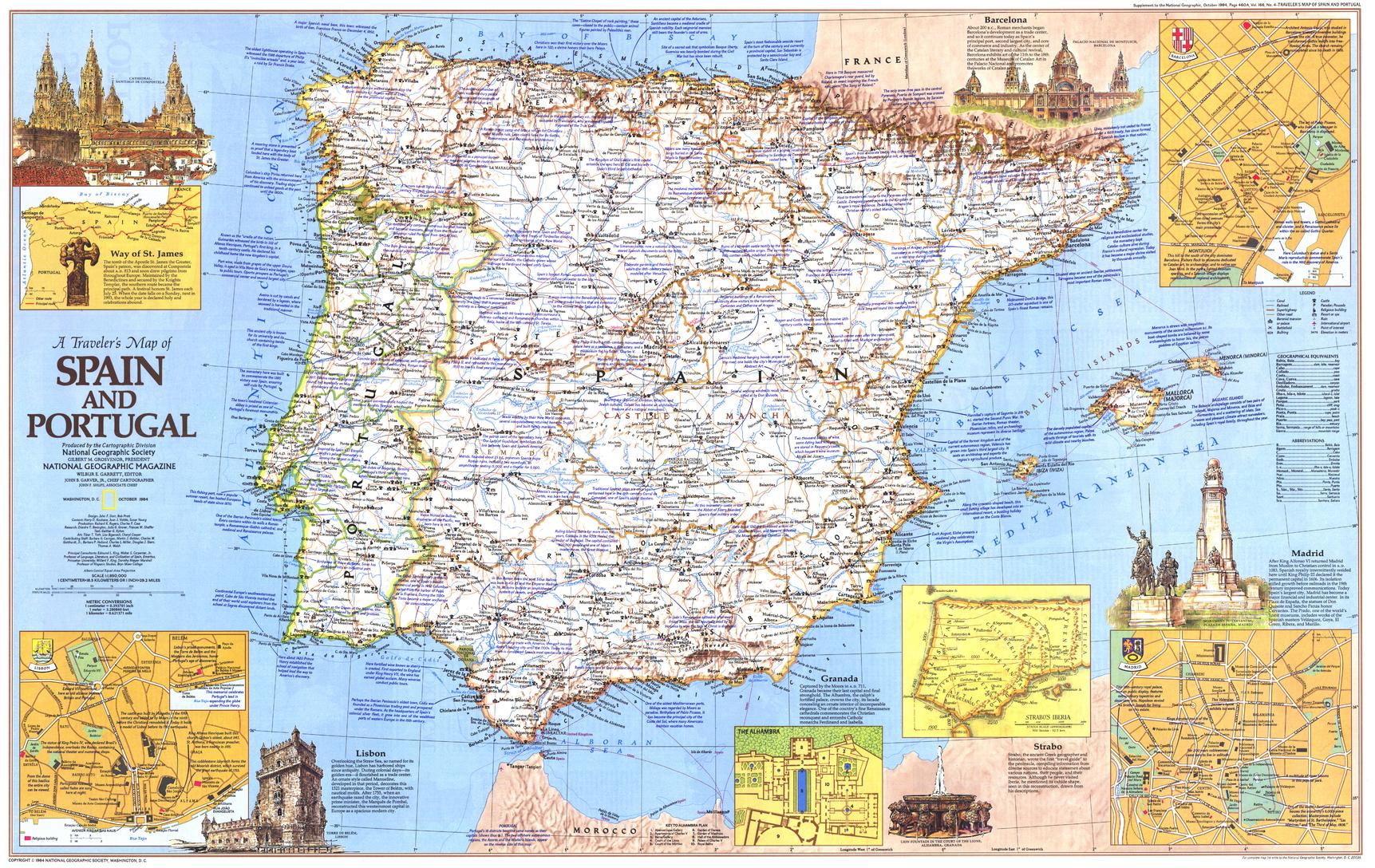
24. Traveler’s Map of Spain — National Geographic 1984
The Best Historical Travel Map
The Traveler’s Map of Spain published in 1984 by National Geographic covers Spain and Portugal at 1:1,850,000.
It includes historical and cultural annotations, the pilgrimage route to Santiago de Compostela and inset maps of Madrid, Barcelona and Lisbon as they appeared in the mid-1980s. The map measures approximately 912 × 576 mm.
Best For
Choose it when:
-
travel history is the main interest;
-
the Camino de Santiago has personal significance;
-
the recipient remembers travelling in Spain during the 1980s;
-
the map is for a study, library or travel-themed room;
-
National Geographic historical maps are being collected.
25. Spain and Portugal — National Geographic 1965
The Spain and Portugal National Geographic Map from 1965 presents the Iberian Peninsula during a period of rapid social, economic and tourism development.

Its shaded terrain, city insets and period transport networks make it valuable for:
-
historical comparison;
-
mid-century cartography;
-
libraries and studies;
-
family-history projects;
-
decorative display.
It should be understood as a historical snapshot rather than a modern travel map.
Europe Wall Maps
A complete Europe map is more useful when Spain forms part of a longer continental journey.
Relevant choices include:
These maps show how Spain connects with Portugal, France, the Mediterranean, North Africa and the rest of Europe.
For onward journeys, read:
Paper, Laminated, Waterproof or Atlas?
Folded Paper Maps
Paper maps are best for:
-
conventional road travel;
-
glovebox storage;
-
permanent notes;
-
carrying several regional maps;
-
economical map kits.
Michelin national and regional maps are the strongest traditional paper choices.
Waterproof Synthetic Maps
Waterproof maps are best for:
-
walking;
-
cycling;
-
motorcycle travel;
-
camping;
-
mountain weather;
-
repeated folding;
-
carrying outside a vehicle.
Relevant choices include:
-
Spain & Portugal National Geographic;
-
Northern Spain National Geographic;
-
Pyrenees & Andorra National Geographic.
Soft-Laminated Borch Maps
Borch maps are:
-
compact;
-
wipe clean;
-
water resistant;
-
suitable for frequent unfolding;
-
particularly useful inside cities.
The Madrid and Barcelona maps are good daily companions, although their listed edition dates should be considered and current transport information checked separately.
Road Atlases
The Michelin road atlas is best for:
-
long self-drive journeys;
-
minor roads;
-
detailed rural exploration;
-
motorhome travel;
-
page-by-page route following.
Professionally Laminated Wall and ITMB Maps
Lamination provides:
-
a wipe-clean surface;
-
protection from moisture;
-
compatibility with suitable whiteboard markers;
-
compatibility with removable map dots;
-
increased durability.
A folded map flattened for professional lamination may retain faint original crease lines.
Wall-Map Finishes
Selected Spain, Spain and Portugal, Europe and historical maps are available in several Mapworld finishes.
Paper
Printed on 160 gsm premium matte paper, suitable for framing under glass or mounting on a board.
Laminated
True encapsulation using two sheets of 80-micron gloss laminate, creating a durable and wipe-clean surface.
Laminated with Timber Hang Rails
A laminated map professionally mounted between natural timber rails with hanging cord.
Canvas
Printed on 395 gsm HP Professional Matte Canvas using pigment-based inks for a premium, low-glare finish.
Canvas with Timber Hang Rails
Canvas combined with natural timber rails for a ready-to-hang presentation.
Please allow up to 10 working days for hang-railed maps because each is professionally mounted. Mapworld’s wall-map listings describe these finish options across the Classic, Executive and historical Spain ranges.
Read:
Current Information Still Matters
A printed map provides the established geography and road network.
It cannot tell you:
-
whether a mountain road is closed today;
-
whether wildfire has affected access;
-
whether roadworks have created a major delay;
-
whether a ferry timetable has changed;
-
whether a railway service is disrupted;
-
whether a walking route is temporarily diverted;
-
whether a national park has introduced restrictions;
-
whether parking or low-emission access rules have changed.
Before each major stage, check:
-
current road conditions;
-
local traffic authorities;
-
rail and bus operators;
-
ferry companies;
-
national parks;
-
accommodation providers;
-
official weather information;
-
current government travel advice.
Use the printed map to understand the geography.
Use current information to decide how the next stage should be travelled.
Why Paper Maps Still Matter in Spain
Spain’s great journeys are defined by geography.
The Pyrenees separate the Iberian Peninsula from the rest of Europe. The central plateau influences the roads radiating from Madrid. Mountain ranges divide Andalusia’s great cities from its coastlines. Northern Spain’s Atlantic valleys are entirely different from the dry landscapes of Castilla-La Mancha or Murcia.
A paper map allows travellers to see:
-
how Madrid sits at the centre of the national road system;
-
why Barcelona belongs to both Mediterranean Spain and the Pyrenean world;
-
how the Camino crosses northern Spain;
-
where Galicia meets Portugal;
-
how Andalusia connects the Atlantic and Mediterranean;
-
why the Balearic and Canary islands require separate mapping;
-
how road, rail and ferry routes fit together.
Digital navigation answers:
Where is my next turn?
A good paper map answers:
Where does this journey belong within Spain?
That wider understanding transforms a sequence of reservations into a coherent journey.
Why Buy Spain Maps from Mapworld?
The Mapworld Spain and Portugal collection extends far beyond one general map of Spain.
It includes:
-
national Michelin, National Geographic and Hallwag maps;
-
a detailed Michelin road atlas;
-
maps of Galicia;
-
Asturias and Cantabria;
-
the Basque Country, Navarra and Rioja;
-
Catalonia, Aragón and Andorra;
-
Castilla, León and Madrid;
-
Extremadura and Castilla-La Mancha;
-
Valencia and Murcia;
-
Andalusia;
-
the Balearic Islands;
-
Camino de Santiago maps and map books;
-
Madrid and Barcelona city maps;
-
Pyrenees maps;
-
Spain and Iberian wall maps;
-
historical National Geographic maps.
The Wall Maps of Countries and Regions collection adds country, regional, continental and historical maps in paper, laminated, canvas and timber hang-railed formats.
A general retailer may offer one small map of Spain.
Mapworld provides the national, regional, city, pilgrimage, mountain, atlas and wall-map layers needed to understand the country properly.
Read Why Specialist Map Shops Remain Important and Mapworld and the Travel Industry for more on the value of specialist range and itinerary planning.
Complete Mapworld Spain Map Directory
National Maps and Atlases
Northern Spain and Camino Maps
Northeastern Spain and the Pyrenees
-
Pyrenees Reise Know-How Map — check availability
Central Spain
Eastern and Southern Spain
Modern Wall Maps
Historical Maps
Relevant Collections
Related Mapworld Articles
Continue planning with:
-
Best Maps and Guides for the Camino de Santiago — detailed guidance on Camino map books, route maps and supporting regional coverage.
-
Best Maps of France — useful when crossing the Pyrenees or combining Spain with southwestern France.
-
Best Maps for Italy — relevant for a wider Mediterranean or southern European journey.
-
Best Maps for the Balkans — useful when Spain forms part of a longer European road trip.
-
Best Maps for Cruising — relevant for Barcelona, Valencia, Málaga and Balearic cruise itineraries.
-
Best Maps for the United Kingdom — useful for longer European journeys beginning or ending in Britain.
-
Paper Maps vs Google Maps: Which Is Better for Trip Planning?.
-
GPS Disruption and Why Paper Maps Are a Strategic Necessity.
Final Verdict
The best map for Spain depends on the journey.
Best Overall Road Map
The Spain & Portugal Michelin Map 734 is the strongest single folded road map for national and cross-border touring.
Best Waterproof Map
The Spain & Portugal National Geographic Folded Map is the strongest durable national option, with roads, physical geography, protected areas and island coverage on waterproof synthetic material.
Best Detailed Road Reference
The Michelin Spain & Portugal Road Atlas is the best choice for a long self-drive journey, providing 1:400,000 mapping across 243 spiral-bound pages.
Best Single-Sided Planning Map
The Spain Portugal Hallwag Map provides a clear one-sided view of the Iberian Peninsula.
Best Regional Maps
Michelin’s numbered Spain series provides the strongest detailed road coverage:
-
571 for Galicia;
-
572 for Asturias and Cantabria;
-
573 for the Basque Country, Navarra and Rioja;
-
574 for Catalonia, Aragón and Andorra;
-
575 for Castilla, León and Madrid;
-
576 for Extremadura, Castilla-La Mancha and Madrid;
-
577 for Valencia and Murcia;
-
578 for Andalusia;
-
579 for the Balearic Islands.
Best Camino Map
The Michelin Camino de Santiago Map Book 160 is the strongest compact map book for the complete Spanish Camino Francés.
The National Geographic Northern Spain Map is the best broad waterproof overview.
Best Pyrenees Map
The Pyrenees & Andorra National Geographic Map provides the strongest waterproof regional coverage.
The Andorra & The Pyrenees ITMB Map supplies greater detail within Andorra.
Best City Maps
The Madrid and Barcelona Borch maps are compact, laminated and useful for daily urban orientation, although their edition dates mean they should be supplemented with current public-transport information.
Best Wall Map
The Spain Wall Map 914 × 610 mm is the strongest dedicated Spain reference.
The Spain & Portugal National Geographic Wall Map is better for complete Iberian context.
The Executive edition is the strongest decorative option.
Best Historical Map
The Traveler’s Map of Spain from 1984 provides the most evocative combination of travel, culture, city insets and Camino heritage.
Best Complete Spain Map Kit
For a substantial journey, carry:
-
one national Spain and Portugal map;
-
the Michelin road atlas;
-
a detailed map for the principal region;
-
city maps for longer urban stays;
-
waterproof mapping for the Camino or Pyrenees;
-
offline digital navigation;
-
current road, rail, ferry and weather information.
Spain rewards travellers who step back far enough to see the entire country.
The right maps will not shorten the road from Madrid to Andalusia, remove traffic from Barcelona or guarantee clear weather in the Pyrenees.
They will, however, help travellers understand:
-
how Spain’s regions fit together;
-
where mountains and plateaus shape the road network;
-
why northern and southern Spain require different mapping;
-
how the Camino crosses the country;
-
where Spain connects with Portugal, France and the Mediterranean;
-
when a national, regional, city, pilgrimage, mountain or wall map is required.
Across a country of such geographic and cultural variety, that wider understanding is invaluable.
Frequently Asked Questions
What is the best overall road map of Spain?
The Spain & Portugal Michelin Map 734 is the strongest overall folded road map.
What is the best waterproof map of Spain?
The Spain & Portugal National Geographic Folded Map is waterproof and tear resistant.
What is the best road atlas of Spain?
The Spain & Portugal Road Atlas Michelin provides detailed 1:400,000 mapping across 243 spiral-bound pages.
Do I need both a national map and a road atlas?
For a substantial self-drive journey, yes. The national map shows the complete route, while the atlas provides greater daily road detail.
What is the best map for northern Spain?
The Northern Spain National Geographic Map is the best broad waterproof option. Add the relevant Michelin regional map for greater road detail.
What is the best map for the Camino de Santiago?
The Camino de Santiago Michelin Map Book 160 is the strongest compact map book for the Spanish Camino Francés.
What is the best map for Galicia?
The Galicia Michelin Map 571 provides detailed 1:400,000 coverage.
What is the best map for the Basque Country and Rioja?
The Basque Country, Navarra & Rioja Michelin Map 573 is produced at 1:250,000 and includes a Bilbao inset.
What is the best map for Barcelona and Catalonia?
Use the Cataluña, Aragón & Andorra Michelin Map 574 with the Barcelona Borch Map.
What is the best map for Madrid and central Spain?
Use Michelin Map 575 for routes north and northwest of Madrid, or Michelin Map 576 for Castilla-La Mancha, Extremadura and routes towards Andalusia and Portugal.
What is the best map for Andalusia?
The Andalucia Michelin Map 578 is the strongest dedicated road map.
What is the best map for Valencia and Murcia?
The Valencia & Murcia Michelin Map 577 provides detailed regional coverage.
What is the best map of the Balearic Islands?
The Balearic Islands Michelin Map 579 covers Mallorca, Menorca, Ibiza and Formentera at 1:140,000.
What is the best map for the Pyrenees?
The Pyrenees & Andorra National Geographic Map is the strongest waterproof regional option.
What is the best map of Andorra?
The Andorra & The Pyrenees ITMB Map maps Andorra at 1:40,000.
What is the best wall map of Spain?
The Spain Wall Map 914 × 610 mm is the strongest dedicated Spain map.
Are Spain wall maps available laminated?
Yes. Selected wall maps are available in paper, laminated, laminated with timber hang rails, canvas and canvas with timber hang rails.
Can laminated maps be written on?
Yes. Suitable whiteboard markers can be used and wiped clean.
Can removable map dots be used?
Yes. Map dots are useful for marking routes, cities, accommodation, family connections and places visited.
Are Spain wall maps available on canvas?
Yes. Selected maps are printed on 395 gsm HP Professional Matte Canvas using pigment-based inks.
How long do hang-railed maps take?
Please allow up to 10 working days because each hang-railed map is professionally mounted.
Does Mapworld sell historical maps of Spain?
Yes. The range includes National Geographic’s Traveler’s Map of Spain from 1984 and its Spain and Portugal map from 1965.
Where can I buy Spain maps in Australia?
Mapworld stocks national, regional, city, Camino, Pyrenees, road-atlas, wall and historical maps of Spain with Australia-wide delivery.
Written by Christopher O’Keeffe
Managing Director of Mapworld and specialist in maps, navigation and cartographic products.


Leave a comment
Comments will be approved before showing up.
Also in Map Guides, Travel Tips & Reviews

How to Read a Topographic Map in Australia
Learn to see the landscape in a topographic map. This practical Australian guide explains scale, contours, landforms, grid references and north references, with worked examples and advice on choosing the right sheet.

How to Treat a Flag: A Guide for the Properly Patriotic
A flag carries more than colour. Christopher O’Keeffe explores the meaning behind respectful flag care, from the first raising at dawn to the dignified retirement of a flag that has served its time.

Best Maps of Australia: How to Choose the Right Australian Map
The best Australian map depends on what you need it to do. Christopher O’Keeffe explains how to choose wall maps, road atlases, topographic sheets, 4WD maps and business maps, with practical advice on scale, coverage, editions, finishes and custom printing, drawn from 25 years in map retailing and printing.
© 2026 Mapworld. Website designed by Genie Media


X
Christopher O'Keeffe
Author