- Australia ▾
- Topographic
▾
- Australia AUSTopo 250k (2025)
- Australia 50k Geoscience maps
- Australia 100k Geoscience maps
- Australia 250k Geoscience maps
- Australia 1:1m Geoscience maps
- New Zealand 50k maps
- New Zealand 250k maps
- New South Wales 25k maps
- New South Wales 50k maps
- New South Wales 100k maps
- Queensland 10k maps
- Queensland 25k maps
- Queensland 50k maps
- Queensland 100k maps
- Western Australia 25k maps
- Western Australia 50k maps
- Western Australia 100k maps
- Compasses
- Software
- GPS Systems
- International ▾
- Wall Maps
▾
- World
- Australia & New Zealand
- Countries, Continents & Regions
- Historical
- Vintage National Geographic
- Australian Capital Territory
- New South Wales
- Northern Territory
- Queensland
- South Australia
- Tasmania
- Victoria
- Western Australia
- Celestial
- Children's
- Mining & Resources
- Wine Maps
- Healthcare
- Postcode Maps
- Electoral Maps
- Nautical ▾
- Flags
▾
- Australian Flag Sets & Banners
- Flag Bunting
- Handwavers
- Australian National Flags
- Aboriginal Flags
- Torres Strait Islander Flags
- International Flags
- Flagpoles & Accessories
- Australian Capital Territory Flags
- New South Wales Flags
- Northern Territory Flags
- Queensland Flags
- South Australia Flags
- Tasmania Flags
- Victoria Flags
- Western Australia Flags
- Gifts ▾
- Globes ▾
Dear valued customer. Please note that our checkout is not supported by old browsers. Please use a recent browser to access all checkout capabilities
Captain Cook and the Mapping of Australia

Captain Cook and the Mapping of Australia
How one voyage, one coastline, and a series of extraordinary charts helped change the way the world understood Australia.
Few names in maritime history are as closely associated with mapping, exploration, and the Pacific world as Captain James Cook.
Cook was not simply an explorer in the romantic sense.
He was a navigator.
A surveyor.
A cartographer.
A disciplined observer whose charts helped turn vast unknown coastlines into measurable geography.
For Australia, Cook’s importance lies especially in his 1770 voyage aboard HMS Endeavour, when he charted the east coast of the continent and named it New South Wales. His work did not “discover” Australia in any simple sense — Aboriginal and Torres Strait Islander peoples had lived on and cared for this continent for tens of thousands of years, and European navigators had encountered other Australian coasts before him. But Cook’s east-coast survey became one of the most consequential mapping events in Australian history.
It brought the eastern shoreline of New Holland into British cartographic knowledge.
It produced charts that circulated through Europe.
It helped shape later British settlement.
And it became part of the larger story of how Australia moved from scattered coastal fragments on maps to a continent increasingly measured, surveyed, named, and claimed.
At Mapworld, our Historical Wall Maps and Historical Charts collections include powerful reproductions that allow customers to explore this cartographic turning point — especially through Captain Cook’s voyages, the mapping of Australia’s east coast, and the later Admiralty and Terra Australis charts that built upon the age of exploration.
Why Captain Cook Matters to Australian Cartography
Cook’s reputation as a mapmaker was not accidental.
Before reaching the Pacific, he had already developed skill in coastal survey and navigation. By the time he sailed aboard Endeavour, Cook had the practical experience needed to observe coastlines with remarkable precision.
His charts mattered because they were useful.
They were not decorative fantasies.
They were working documents.
They were created from bearings, soundings, observations, coastal profiles, astronomical measurements, and hard-won experience at sea.
In 1770, as Endeavour travelled along Australia’s east coast, Cook and his officers recorded headlands, bays, islands, reefs, river mouths, shoals, anchorages, and coastal features. This was dangerous work. The Great Barrier Reef nearly ended the expedition when Endeavour struck the reef and required repairs at what became known as the Endeavour River.
The resulting mapping helped place the east coast of Australia into a more complete European geographic framework.
It was not the end of Australian charting.
It was a beginning.
The Endeavour Voyage: 1768–1771
Cook’s first Pacific voyage began in 1768 and returned in 1771.
The official purpose included scientific observation, particularly the transit of Venus, but the voyage became one of the great mapping expeditions of the eighteenth century.
The journey included:
-
Tahiti
-
New Zealand
-
Australia’s east coast
-
the Great Barrier Reef region
-
Batavia
-
the return to England
For Australian history, the critical moment came in 1770, when Cook charted the eastern coast from Point Hicks northward.
The voyage produced one of the foundational European cartographic records of the Australian east coast.
This is why Captain Cook maps and charts remain so significant today.
They show geography becoming history.
Cook’s East Coast: From Point Hicks to Cape York
Cook’s east-coast charting traced a coastline that would later become central to the British settlement story.
Names associated with the voyage still echo through Australian geography:
-
Botany Bay
-
Point Hicks
-
Cape Howe
-
Port Jackson
-
Moreton Bay
-
Cape Tribulation
-
Endeavour River
-
Cape York
Some names were recorded, some were bestowed, and others were later adjusted by surveyors and cartographers.
This is one of the most fascinating things about historical maps.
They do not simply show geography.
They show moments of naming, interpretation, encounter, and power.
A coastline already rich with Aboriginal names, knowledge, stories, and meaning was being translated into European nautical language.
That makes Cook-era maps historically important, but also complex.
They are records of navigation and exploration.
They are also documents of colonisation.
Map of the Voyages of Captain Cook
One of the most important Captain Cook pieces in Mapworld’s Historical Wall Maps collection is the Map of the Voyages of Captain Cook.
This detailed historical reproduction charts the full sweep of Cook’s three major voyages and other eighteenth-century naval expeditions.

It captures:
-
The voyage of the Endeavour from 1768 to 1771
-
Cook’s charting of Australia’s east coast and New Zealand
-
The voyage of Resolution and Adventure from 1772 to 1775
-
Cook’s second expedition into the Southern Ocean
-
The voyage of Resolution and Discovery from 1776 to 1780
-
Cook’s final journey and death in Hawaii
-
Other historic naval routes, including the Arctic voyage of HMS Racehorse and HMS Carcass
This map is powerful because it places Australia within Cook’s broader Pacific world.
The east coast of Australia is not isolated.
It sits within a vast network of oceanic routes, scientific ambition, imperial strategy, and Enlightenment-era exploration.
For classrooms, studies, libraries, museums, maritime collectors, and history lovers, this map gives the full context of Cook’s career.
Why the Voyages Map Works So Well as Wall Art
The Map of the Voyages of Captain Cook has immediate visual drama.
It is not a single coastline.
It is an oceanic story.
The viewer can trace the route lines across the Pacific, Southern Ocean, New Zealand, Australia, the Arctic and beyond.
You can see movement.
Risk.
Return.
Correction.
Ambition.
This makes it ideal for:
-
history classrooms
-
libraries
-
studies
-
maritime offices
-
naval collections
-
home offices
-
museums and interpretive displays
-
collectors of exploration history
It is both educational and decorative.
A map like this rewards repeated viewing. Every time you look, another route, date, annotation, coastline or historical connection emerges.
Captain Cook’s Voyages World Wall Map Published 1801
Another standout Mapworld piece is Captain Cook’s Voyages World Wall Map Published 1801.
This map has a slightly different character.
Where the 1790-style Voyages map captures Cook’s expeditions as a grand historical chart, the 1801 world map presents Cook’s routes within a broader world view.
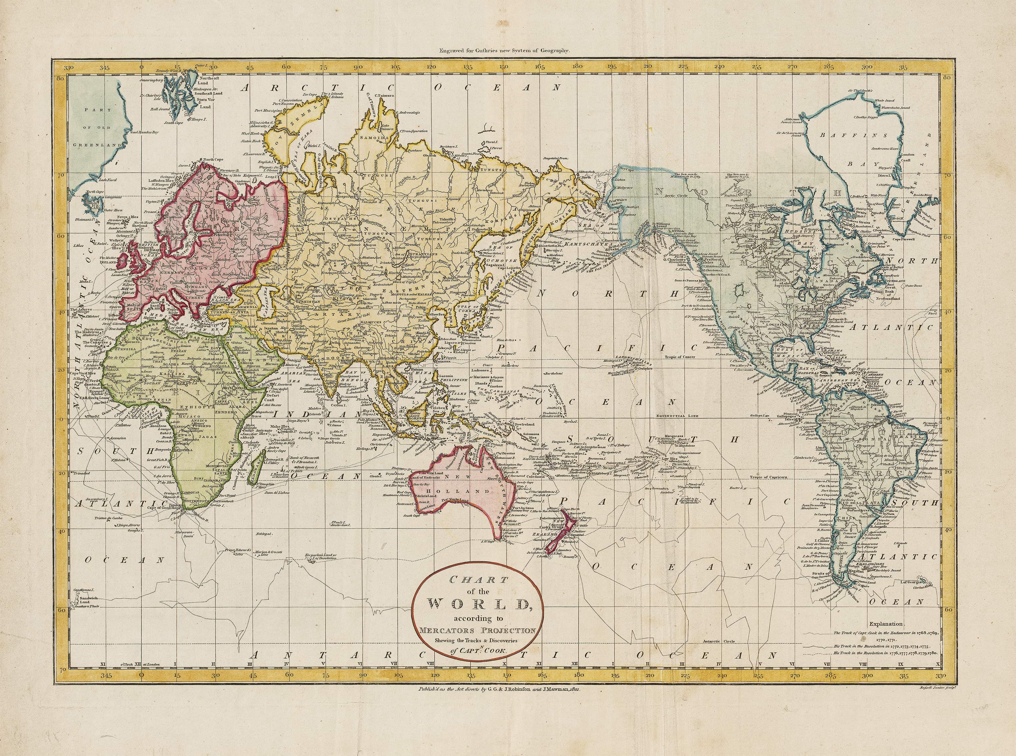
It gathers the tracks of Endeavour, Resolution, and Discovery into a single global portrait of exploration. It also includes routes associated with later navigators such as Vancouver and La Pérouse, helping show how Cook’s work sat within a wider period of Pacific and global charting.
This is one of the most elegant features of the map.
It does not treat Cook as an isolated figure.
It shows him among the great navigators whose routes collectively sharpened the outline of the world.
Australia, New Zealand, the Pacific, the North American northwest coast and parts of Asia all appear within a larger cartographic story.
This makes the 1801 Captain Cook wall map especially appealing for customers who want a world map with historical depth rather than a purely modern political reference map.
Sizes and Finishes for Captain Cook Maps
Mapworld’s Captain Cook maps are available in multiple sizes and finishes, making them suitable for both educational use and premium wall display.
Map of the Voyages of Captain Cook
Available in:
-
Large paper
-
Large laminated
-
Large laminated with hang rails
-
Large canvas
-
Large canvas with hang rails
-
Supermap paper
-
Supermap laminated
-
Supermap laminated with hang rails
-
Supermap canvas
-
Supermap canvas with hang rails
Size options include:
-
Large — 920 mm wide × 630 mm high
-
Supermap — 1500 mm wide × 870 mm high
The Supermap version is particularly impressive for teaching spaces, offices, and feature walls because the route lines and annotations become easier to follow.
Captain Cook’s Voyages World Wall Map Published 1801
Available in:
-
800 × 600 mm paper
-
800 × 600 mm laminated
-
800 × 600 mm laminated with hang rails
-
800 × 600 mm canvas
-
800 × 600 mm canvas with hang rails
-
1350 × 1000 mm paper
-
1350 × 1000 mm laminated
-
1350 × 1000 mm laminated with hang rails
-
1350 × 1000 mm canvas
-
1350 × 1000 mm canvas with hang rails
-
1900 × 1400 mm canvas
-
1900 × 1400 mm canvas with hang rails
These choices allow the map to work as an intimate framed study piece or as a commanding boardroom-scale historical display.
Paper, Laminated or Canvas?
The best finish depends on how the map will be used.
Paper
Choose paper if the map will be professionally framed under glass or acrylic.
Paper is ideal for:
-
studies
-
libraries
-
traditional interiors
-
framed historical displays
-
collectors
It gives the map a classic archival feel.
Laminated
Choose laminated if the map will be used in an educational or shared environment.
Lamination provides:
-
wipe-clean durability
-
protection from handling
-
write-on/wipe-off use
-
greater resistance to moisture and wear
This is excellent for schools, museums, libraries, maritime clubs and teaching spaces.
Laminated + Timber Hang Rails
This is a practical display option for larger maps.
It gives a polished ready-to-hang appearance without the cost and weight of traditional framing.
Ideal for:
-
classrooms
-
offices
-
libraries
-
training spaces
-
heritage displays
Canvas
Canvas turns the map into wall art.
It is ideal for:
-
premium interiors
-
executive offices
-
boardrooms
-
home libraries
-
maritime-themed rooms
-
collector displays
Mapworld’s canvas maps are printed on 395 gsm HP Professional Matte Canvas using pigment-based, fade-resistant inks.
Canvas + Timber Hang Rails
This combines the warmth of canvas with a clean ready-to-hang presentation.
It works particularly well for large historical maps where traditional framing may be impractical.
Cook Maps as Educational Tools
Captain Cook maps are especially valuable in schools and universities because they support multiple areas of learning.
They can be used in:
-
Australian history
-
geography
-
maritime studies
-
colonial history
-
cartography
-
Pacific studies
-
Indigenous history discussions
-
navigation and exploration units
A Cook map allows teachers and students to ask deeper questions:
-
How were coastlines mapped before satellite imagery?
-
Why did European powers care so much about the Pacific?
-
How did scientific exploration connect with imperial ambition?
-
What did Cook’s charts make visible to Europe?
-
What did those maps leave out?
-
How did mapping contribute to colonisation?
-
How do Indigenous understandings of Country differ from European nautical charts?
These maps are powerful precisely because they are not simple.
They allow students to see both the achievement of navigation and the consequences of claiming and naming land.
Cook, Botany Bay and Endeavour River
Two places are especially important in Cook’s Australian mapping story: Botany Bay and Endeavour River.
Botany Bay became one of the most famous locations associated with the Endeavour voyage.
Endeavour River became critical because it was where the damaged ship was repaired after striking the Great Barrier Reef.
Maps of these places show the voyage at a more intimate scale.
They remind us that the mapping of Australia was not only a grand continental process.
It was also made up of close coastal observations, anchorages, river mouths, dangers, repairs and survival.
In historical chart terms, these smaller places matter because they show how exploration moved from the global to the local.
From the Pacific.
To Australia.
To a bay.
To a river.
To the practical problem of keeping a ship afloat.
From Cook to Flinders: The Mapping Story Continues
Cook’s 1770 charting of the east coast was foundational, but it did not complete the mapping of Australia.
Later navigators and surveyors refined, corrected, extended and connected what Cook and others had recorded.
This is where Mapworld’s Historical Charts collection becomes especially important.
Charts such as the Chart of Terra Australis — Sheet I, East Coast (1798–1831) and Chart of Terra Australis — Sheet III, East Coast (1802–1841) show the next great phase of Australian charting.
Matthew Flinders and later hydrographers helped place Australia into a more complete continental form.
The Terra Australis charts show the evolution from Cook’s east-coast survey toward a broader, more unified understanding of the Australian coastline.
This is one of the most fascinating ways to display historical charts.
A Cook voyage map shows the expeditionary moment.
A Terra Australis chart shows the systematic refinement that followed.
Together, they tell the story of Australia becoming fully charted in European maritime terms.
Historical Charts That Complement Captain Cook Maps
Mapworld’s Historical Charts collection includes several pieces that pair beautifully with Captain Cook maps.
Chart of Terra Australis — Sheet I, East Coast
This chart is one of the strongest companions to a Cook-focused display because it continues the story of Australia’s eastern coastline.
It shows the east coast not just as a route of discovery, but as a refined hydrographic document shaped by later survey and Admiralty charting.
Chart of Terra Australis — Sheet III, East Coast
This sheet adds further depth to the eastern coastline story, showing how the mapping of Australia evolved through successive surveys and corrections.
Chart of the Great Barrier Reef Area (1893)
Cook’s near-disaster on the reef gives the Great Barrier Reef a special place in the story of Australian navigation.
A later Great Barrier Reef chart helps show how one of the world’s most complex marine environments continued to demand careful mapping.
Port Jackson Historic British Admiralty Chart
Although Cook noted the coast north of Botany Bay, Port Jackson later became central to British settlement.
A Port Jackson chart provides a powerful follow-on piece for anyone interested in the connection between Cook’s voyage, British knowledge of the east coast, and the development of Sydney Harbour.
Australia — East Coast Port Curtis (1848)
This chart reflects the continuing nineteenth-century survey of Australia’s east coast, long after Cook’s original voyage.
It shows how coastal mapping remained an active, practical and strategic task.
Together, these historical charts form a layered story: Cook’s first charting, Flinders’ continental surveys, Admiralty refinement, and the detailed mapping of harbours, reefs and ports.
Historical Wall Maps That Complement Captain Cook Maps
Mapworld’s Historical Wall Maps collection also offers strong companion pieces.
A Cook map sits beautifully alongside:
-
historical world maps
-
Pacific exploration maps
-
antique-style Australia maps
-
Terra Australis maps
-
colonial-era maps
-
early Australian wall maps
-
maps showing global exploration routes
These maps provide context.
They show the world as Cook’s contemporaries imagined it.
They reveal how quickly geographic knowledge was changing in the late eighteenth and early nineteenth centuries.
A Captain Cook map is powerful on its own.
But when paired with historical wall maps of Australia or the Pacific, it becomes part of a broader cartographic gallery.
How to Display Captain Cook Maps and Charts
For a Study or Library
Choose:
-
paper
-
framed presentation
-
800 × 600 mm or 1350 × 1000 mm sizes
-
warm timber or dark frame
-
soft lighting
This creates a scholarly, heritage-rich feel.
For a Classroom
Choose:
-
laminated
-
Supermap size
-
hang rails
-
write-on/wipe-off capability
This allows students to trace routes and interact with the map.
For a Boardroom
Choose:
-
canvas
-
large format
-
hang rails or professional framing
-
paired historical charts
This creates a serious, authoritative display.
For a Maritime or Coastal Home
Choose:
-
canvas
-
historical chart pairing
-
nautical styling
-
natural timber hang rails
Cook maps pair beautifully with Admiralty charts, Great Barrier Reef charts and Terra Australis sheets.
Why Captain Cook Maps Make Strong Gifts
Captain Cook maps are highly suitable gifts for people who love:
-
Australian history
-
maritime history
-
exploration
-
sailing
-
navigation
-
cartography
-
libraries and studies
-
historical interiors
-
teaching and education
They are particularly meaningful for:
-
retired sailors
-
teachers
-
historians
-
collectors
-
coastal homeowners
-
naval enthusiasts
-
museum supporters
-
graduates in history or geography
A Cook map has both visual and intellectual presence.
It is a gift that invites conversation.
A Note on Historical Complexity
Any article about Captain Cook and Australia must acknowledge complexity.
Cook’s charts are extraordinary navigational documents.
They represent skill, discipline and scientific observation.
But they are also tied to the beginning of British colonisation on Australia’s east coast and to histories of dispossession for Aboriginal peoples.
To display a Cook map thoughtfully is not to ignore this complexity.
It is to engage with it.
Historical maps are valuable because they show how people understood, named, claimed and represented the world at particular moments in time.
They allow us to ask:
-
Who made this map?
-
What did it show?
-
What did it omit?
-
Whose knowledge was recorded?
-
Whose knowledge was ignored?
-
What consequences followed?
That is why Cook maps remain important.
They are beautiful historical objects.
They are also documents that shaped real history.
Why Buy Historical Maps and Charts from Mapworld?
Mapworld’s Historical Wall Maps and Historical Charts collections bring together premium reproductions for people who value history, geography, navigation and design.
The collections include:
-
Captain Cook voyage maps
-
Captain Cook’s Voyages World Wall Map Published 1801
-
Terra Australis charts
-
British Admiralty charts
-
Port Jackson charts
-
Great Barrier Reef charts
-
historical Australian wall maps
-
colonial-era maps
-
early world and Pacific maps
Many are available in:
-
paper
-
laminated
-
laminated with timber hang rails
-
canvas
-
canvas with timber hang rails
This makes them suitable for homes, schools, libraries, museums, offices, maritime clubs and collector spaces.
Whether you want a single Cook map or a complete historical chart display, Mapworld’s range allows you to build a wall that tells a story.
Final Thoughts
Captain Cook’s maps and charts occupy a central place in the mapping of Australia.
They show the east coast entering European cartographic knowledge.
They record the routes of one of the most significant navigators of the eighteenth century.
They reveal the ambition, science, danger and consequence of maritime exploration.
But they are also part of a larger story.
A story that includes earlier European navigators.
Indigenous knowledge of Country.
Matthew Flinders.
British Admiralty hydrographers.
Great Barrier Reef surveyors.
Harbour chartmakers.
And the long process by which Australia was mapped, named, understood and contested.
Displayed on the wall, a Captain Cook map is more than decoration.
It is a conversation about exploration, empire, science, coastline, memory and place.
It reminds us that maps do not simply show history.
They help make it.
Frequently Asked Questions
What Captain Cook maps are available from Mapworld?
Mapworld offers Captain Cook historical reproductions including the Map of the Voyages of Captain Cook and Captain Cook’s Voyages World Wall Map Published 1801.
What does the Map of the Voyages of Captain Cook show?
It shows Cook’s three major voyages, including the Endeavour voyage of 1768–1771, the charting of Australia’s east coast and New Zealand, and later voyages into the Southern Ocean and North Pacific.
What is special about Captain Cook’s Voyages World Wall Map Published 1801?
It presents Cook’s three voyages within a global historical world map, alongside routes associated with other navigators such as Vancouver and La Pérouse. It is both a world map and a record of exploration.
Are Captain Cook maps suitable for classrooms?
Yes. Laminated versions are especially suitable for classrooms because they are durable, wipe-clean and useful for teaching exploration, cartography, Australian history and Pacific geography.
Are Captain Cook maps suitable for wall art?
Yes. Paper and canvas versions are excellent for studies, libraries, boardrooms, coastal homes, maritime offices and historical interiors.
Which historical charts pair well with Captain Cook maps?
Excellent companion pieces include Chart of Terra Australis — Sheet I, East Coast; Chart of Terra Australis — Sheet III, East Coast; Chart of the Great Barrier Reef Area; Port Jackson Historic British Admiralty Chart; and Australia — East Coast Port Curtis.
Should I choose paper, laminated or canvas?
Choose paper for framing, laminated for classrooms and shared spaces, canvas for premium wall display, and hang rails for easy ready-to-hang presentation.
Are these maps suitable for modern navigation?
No. Captain Cook maps and historical charts are decorative, educational and historical reproductions. They should not be used for modern navigation.

Leave a comment
Comments will be approved before showing up.
Also in Map Guides, Travel Tips & Reviews

Best Maps for the Munda Biddi Trail
The Munda Biddi Trail is a journey through towering forests, rolling farmland, quiet country towns and the wild landscapes of Western Australia’s south, stretching all the way from Mundaring to Albany. No single map can reveal it all. A complete mapping kit may combine the official seven-map trail series for the route under your wheels, broader South West mapping for road access and resupply, topographic maps for understanding the country beyond the trail, and a wall map to see how the entire journey comes together.

Best Maps for the Bibbulmun Track
The Bibbulmun Track is a journey through towering forests, quiet valleys, wildflower country and the rugged southern coast, unfolding across nearly 1,000 kilometres of Western Australia. No single map can reveal it all. A complete mapping kit may combine the official 1:50,000 map for the section underfoot, northern or southern map packs for longer walks, broader South West mapping for road access and resupply, and a wall map to understand how the entire journey from Kalamunda to Albany comes together.

Best Maps for Kosciuszko National Park
Kosciuszko National Park is a landscape of high ridges, alpine plains, deep valleys and long distances, where the right map can transform how the country is understood. No single map can reveal it all. A complete mapping kit may combine detailed 1:25,000 topographic sheets, a 1:50,000 alpine map, broader 1:100,000 coverage, and a touring or wall map to show how the Main Range, Jagungal, Kiandra, Jindabyne and the wider Snowy Mountains connect as one remarkable alpine landscape.
© 2026 Mapworld. Website designed by Genie Media
X
Christopher O'Keeffe
Author