- Australia ▾
- Topographic
▾
- Australia AUSTopo 250k (2025)
- Australia 50k Geoscience maps
- Australia 100k Geoscience maps
- Australia 250k Geoscience maps
- Australia 1:1m Geoscience maps
- New Zealand 50k maps
- New Zealand 250k maps
- New South Wales 25k maps
- New South Wales 50k maps
- New South Wales 100k maps
- Queensland 10k maps
- Queensland 25k maps
- Queensland 50k maps
- Queensland 100k maps
- Compasses
- Software
- GPS Systems
- Orienteering
- International ▾
- Wall Maps
▾
- World
- Australia & New Zealand
- Countries, Continents & Regions
- Historical
- Vintage National Geographic
- Australian Capital Territory
- New South Wales
- Northern Territory
- Queensland
- South Australia
- Tasmania
- Victoria
- Western Australia
- Celestial
- Children's
- Mining & Resources
- Wine Maps
- Healthcare
- Postcode Maps
- Electoral Maps
- Nautical ▾
- Flags
▾
- Australian Flag Sets & Banners
- Flag Bunting
- Handwavers
- Australian National Flags
- Aboriginal Flags
- Torres Strait Islander Flags
- International Flags
- Flagpoles & Accessories
- Australian Capital Territory Flags
- New South Wales Flags
- Northern Territory Flags
- Queensland Flags
- South Australia Flags
- Tasmania Flags
- Victoria Flags
- Western Australia Flags
- Gifts ▾
- Globes ▾
Dear valued customer. Please note that our checkout is not supported by old browsers. Please use a recent browser to access all checkout capabilities
Best Wall Maps for New South Wales

From statewide planning and logistics to education, travel, regional operations and office display, a large New South Wales wall map is one of the most useful reference tools you can put on the wall.
New South Wales is one of Australia’s most diverse and important states.
It includes the country’s largest city, major regional centres, coastal highways, inland transport corridors, mountain ranges, agricultural districts, national parks, ports, mining regions, tourism areas and remote communities.
From Sydney to Broken Hill.
From the North Coast to the South Coast.
From the Blue Mountains to the Riverina.
From Newcastle to Wollongong.
From the Central West to the Far North Coast.
New South Wales is a state that rewards geographic understanding.
A digital map is excellent for finding one address.
A wall map is better for seeing the whole state at once.
At Mapworld, the New South Wales Wall Maps collection brings together a strong range of maps for homes, schools, government offices, businesses, logistics teams, tourism operators, emergency services, transport companies and anyone who needs a clear, reliable view of New South Wales.
The key choices include:
Each map has a different strength.
The best choice depends on whether you need statewide detail, road and touring context, regional coast coverage, South East Australian perspective, or a long east-coast corridor view.
Why a New South Wales Wall Map Still Matters
New South Wales is not a small state.
It has large distances, busy road corridors, dense urban areas, major regional centres and a coastline that drives much of the state’s economy and lifestyle.
A wall map helps you see:
-
major roads and highways
-
regional towns and cities
-
coastal corridors
-
inland routes
-
state boundaries
-
mountain ranges
-
rivers and waterways
-
national parks
-
service regions
-
logistics networks
-
travel routes
-
business territories
-
education and planning context
A wall map gives the whole room the same reference.
It is useful in:
-
schools
-
government offices
-
business boardrooms
-
logistics centres
-
tourism offices
-
caravan and travel planning spaces
-
emergency-service rooms
-
real estate offices
-
regional planning teams
-
warehouses
-
homes and studies
A good New South Wales wall map turns a complex state into something visible, practical and easy to discuss.
The Two Main Statewide Choices: UBD or Hema
For most customers, the decision begins with two major statewide wall maps.
New South Wales 270 UBD Map
Best for clear, structured state reference.
The UBD style is practical, familiar and excellent for offices, classrooms, government departments and anyone who wants a clean, reliable statewide map.
New South Wales Hema Wall Map
Best for road, touring, travel and regional planning.
Hema maps are trusted by travellers, road users and professionals who need strong road and regional context.
Both maps cover New South Wales.
But they feel different.
The UBD map is especially strong as a general reference and business wall map.
The Hema map is especially strong for road travel, route planning and statewide movement.
Many serious users choose both.
New South Wales 270 UBD Map: The Classic State Reference
The New South Wales 270 UBD Map is one of the most practical wall maps in the Mapworld NSW range.

It is the map to choose when you need a clean, clear, statewide reference for work, education, planning or display.
It is ideal for:
-
government offices
-
schools
-
logistics teams
-
sales territory planning
-
regional businesses
-
transport companies
-
education and training rooms
-
real estate and property offices
-
family travel planning
-
community organisations
-
office display
The UBD 270 gives a strong view of the state, helping users understand the relationship between Sydney, regional centres, road networks, coastal areas, inland towns and neighbouring states.
New South Wales 270 UBD: Three Sizes
Mapworld offers the New South Wales 270 UBD Map in three key wall-map sizes:
Each size suits a different wall and purpose.
1000 × 690 mm New South Wales 270 UBD
Best for:
-
small offices
-
home studies
-
classrooms
-
compact meeting rooms
-
reception areas
-
personal reference
-
framed or laminated display
This is the most compact of the three UBD sizes.
It gives you a strong statewide reference without requiring a large wall.
For homes, smaller offices and classrooms with limited wall space, it is an excellent choice.
1480 × 1020 mm New South Wales 270 UBD
Best for:
-
business offices
-
meeting rooms
-
schools
-
training spaces
-
planning rooms
-
logistics desks
-
regional offices
This is the strong middle size.
It is large enough for group discussion and planning, while still fitting comfortably in most rooms.
For many businesses and schools, the 1480 × 1020 mm size is the ideal balance of readability and practicality.
2000 × 1380 mm New South Wales 270 UBD
Best for:
-
boardrooms
-
large classrooms
-
operations rooms
-
logistics centres
-
government offices
-
planning walls
-
warehouses
-
major business display
This is the serious wall-scale version.
At 2000 × 1380 mm, the map becomes a major feature of the room.
It can be read from a distance, used in meetings and treated as a shared reference for planning and discussion.
For serious business, government or education use, this is often the strongest choice.
New South Wales 270 UBD Formats
The New South Wales 270 UBD range includes laminated and hang-railed options, with canvas also available in selected sizes.
Laminated
Best for:
-
business planning
-
classrooms
-
logistics
-
map dots
-
suitable whiteboard markers
-
repeated use
-
high-traffic rooms
A laminated map becomes a working tool.
You can mark delivery zones, sales regions, branch locations, travel routes or project areas, then wipe the map clean.
Laminated with Hang Rails
Best for:
-
ready-to-hang wall display
-
offices
-
boardrooms
-
training rooms
-
schools
-
large-format maps
Hang rails give the map a professional finished look without full framing.
They are especially useful for the larger 1480 × 1020 mm and 2000 × 1380 mm maps.
Canvas
Best for:
-
home offices
-
boardrooms
-
reception areas
-
feature walls
-
premium display
Canvas gives the map a warmer and more decorative presence, while still retaining the value of a serious state reference map.
New South Wales Hema Wall Map: Best for Road, Touring and Regional Context
The New South Wales Hema Wall Map is the natural choice when road travel, regional movement and touring context matter.

Hema maps are trusted across Australia for practical road and touring cartography.
The NSW Hema map is useful for:
-
road trips
-
caravanning
-
regional travel
-
logistics
-
tourism
-
route planning
-
education
-
field services
-
transport businesses
-
government and regional planning
-
sales representatives covering large areas
This map helps users understand how New South Wales works as a connected state.
It shows towns, cities, highways, secondary roads and key regional connections clearly.
For anyone who needs to understand movement across NSW, the Hema map is an excellent choice.
New South Wales Hema: Three Sizes
Mapworld offers the New South Wales Hema map in three major sizes:
These sizes allow customers to choose between compact display, serious office use and major wall-scale planning.
1000 × 700 mm New South Wales Hema
Best for:
-
homes
-
small offices
-
travel planning
-
classrooms
-
reception areas
-
compact wall spaces
This is the practical standard size.
It is easy to display and useful for general NSW road and regional reference.
It is available in:
-
paper
-
laminated
-
laminated with hang rails
-
canvas
1430 × 1000 mm New South Wales Hema Supermap
Best for:
-
meeting rooms
-
schools
-
travel agencies
-
logistics teams
-
regional offices
-
planning rooms
-
businesses covering NSW
The Supermap size gives the Hema map far more wall presence.
At 1430 × 1000 mm, it becomes easier to read in a room and more useful for group planning.
It is available in:
-
paper
-
laminated with free map dots
-
laminated with hang rails
-
canvas
For many offices and schools, the Supermap is the best everyday large-format choice.
2000 × 1400 mm New South Wales Hema Megamap
Best for:
-
boardrooms
-
operations rooms
-
logistics centres
-
large classrooms
-
government offices
-
transport companies
-
planning walls
-
regional service teams
The Hema Megamap is the premium large-format version.
At 2000 × 1400 mm, it is designed for serious statewide reference.
It is especially valuable when the map needs to be read from across a room or used by a group during planning.
It is available in:
-
paper
-
laminated
-
laminated with hang rails
-
canvas
For serious planning, logistics, education or statewide reference, the Megamap is the strongest Hema option.
Why Choose the New South Wales Hema Megamap?
The New South Wales Hema 2000 × 1400 mm Megamap is one of the most impressive NSW wall maps in the range.
It covers the entire state in a large, readable format and is designed for planning, logistics, education and strategic use.
It is especially useful for:
-
statewide operations
-
transport and delivery planning
-
schools and universities
-
government departments
-
caravan and touring planning
-
business territory mapping
-
regional service networks
-
large wall display
In laminated form, the Megamap becomes a durable write-on/wipe-off planning surface.
It can be used to mark:
-
routes
-
towns
-
customer locations
-
delivery corridors
-
service areas
-
regional offices
-
sales territories
-
school excursions
-
tourism loops
For organisations that need the whole state visible at scale, the Hema Megamap is hard to beat.
South East Australia Meridian Wall Map: Best for Cross-Border Context
The South East Australia Meridian Wall Map is a strong choice when New South Wales needs to be understood in relation to surrounding regions.

This map covers:
-
Victoria
-
south-eastern South Australia
-
the ACT
-
southern New South Wales
It is particularly useful for people and organisations whose work does not stop at the NSW border.
This includes:
-
logistics companies
-
transport planners
-
regional businesses
-
government offices
-
tourism operators
-
education providers
-
caravan and touring travellers
-
freight and distribution teams
-
sales teams covering multiple states
The South East Australia Meridian map is useful because it shows cross-border relationships clearly.
For many businesses, the important question is not just “Where is this in NSW?”
It is:
-
How does NSW connect to Victoria?
-
What are the major road corridors into South Australia?
-
Where does Canberra sit in relation to southern NSW?
-
How do transport routes connect Sydney, Melbourne, Canberra and regional centres?
-
How do regional towns and corridors sit across the south-east of the continent?
The Meridian map answers these questions beautifully.
At 1005 × 815 mm, it is a practical large-format reference map with a strong balance of detail and readability.
North Coast NSW Wall Map: Best for Coastal Planning and Regional Operations
The North Coast NSW 1000 × 1050 mm Laminated Wall Map is ideal for anyone focused on the northern half of the state’s coast and surrounding inland regions.
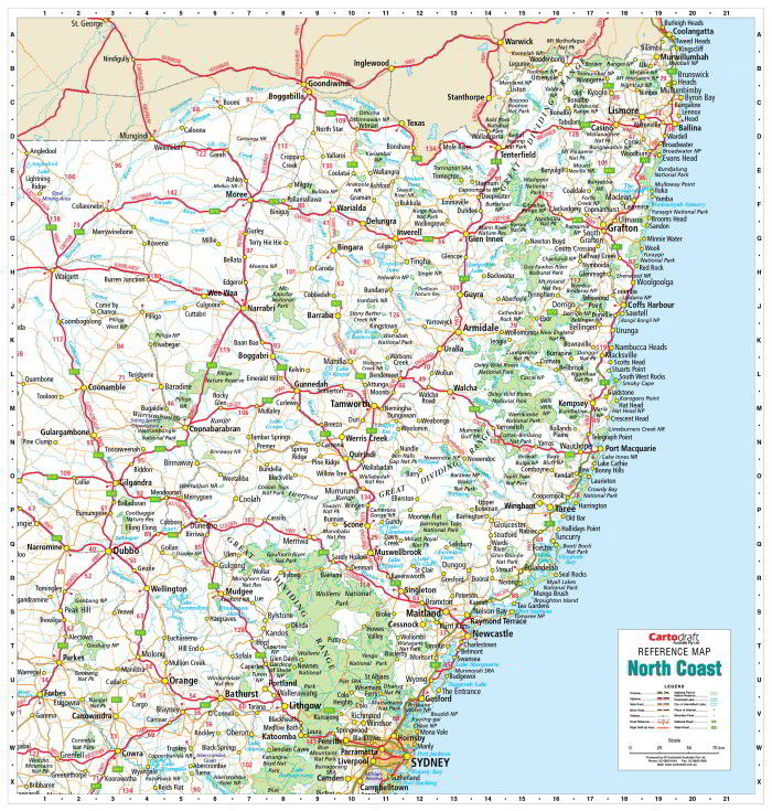
It covers from Coolangatta in the north-east down to Campbelltown in the south-east, and west to Quambone.
That makes it much more than a narrow coastal strip.
It provides a strong view of the North Coast and its inland connections.
It is ideal for:
-
tourism operators
-
accommodation providers
-
regional businesses
-
transport companies
-
logistics teams
-
schools
-
government offices
-
community organisations
-
travellers
-
property and service businesses
The map shows:
-
cities and towns
-
major and minor roads
-
railways
-
waterways
-
national parks
-
regional connections
Because it is laminated, it is durable, writeable and wipe-clean.
That makes it excellent for tourism planning, business operations, education and office use.
For businesses working along the North Coast, this map gives a focused regional view that a statewide map cannot match.
South Coast NSW Wall Map: Best for Illawarra, Shoalhaven and Far South Coast
The South Coast NSW 900 × 1165 mm Laminated Wall Map is designed for the state’s iconic southern coastal corridor.

It covers the region from Sydney’s southern fringes down through:
-
Wollongong
-
Kiama
-
Batemans Bay
-
Narooma
-
Eden
-
the surrounding South Coast region
This map is ideal for:
-
tourism operators
-
accommodation providers
-
coastal businesses
-
local councils
-
schools
-
transport and delivery teams
-
road trip planning
-
caravan travellers
-
regional offices
-
property and real estate professionals
The South Coast is one of Australia’s most distinctive regional corridors.
It combines coastal towns, national parks, state forests, rivers, roads, railways and tourism destinations.
A dedicated South Coast wall map gives the region room to breathe.
For anyone who lives, works or travels along the South Coast, this map is a practical and attractive wall reference.
East Coast Australia Wall Map: Best for the Brisbane–Sydney–Melbourne Corridor
The East Coast Australia 640 × 1400 mm Laminated Wall Map is a different kind of map.

Rather than focusing only on NSW, it follows the long eastern corridor from south-east Queensland through New South Wales and down into eastern Victoria.
It covers:
-
Brisbane
-
Sydney
-
Melbourne
-
Newcastle
-
Coffs Harbour
-
Canberra
-
Wollongong
-
Albury-Wodonga
-
Geelong
-
major highways
-
minor roads
-
rail lines
-
rivers and lakes
-
selected terrain
-
national parks and conservation areas
Its slim vertical format makes it particularly useful for narrow wall spaces, office corridors, classrooms, travel agencies, logistics offices, depots and retail counters.
This map is ideal for:
-
interstate logistics
-
east-coast travel planning
-
education
-
tourism businesses
-
sales teams
-
transport companies
-
caravan and touring customers
-
distribution planning
-
corridor-based business operations
For many Australian businesses, the east coast is the operating spine of the country.
This map makes that corridor visible.
Which New South Wales Wall Map Should You Choose?
Choose New South Wales 270 UBD If:
You need a clean, structured statewide reference map.
Best for:
-
offices
-
schools
-
government
-
business planning
-
general state reference
-
regional awareness
-
display
Recommended sizes:
-
1000 × 690 mm for compact reference
-
1480 × 1020 mm for meeting rooms and classrooms
-
2000 × 1380 mm for boardrooms and serious planning
Choose New South Wales Hema If:
You need road, touring and regional movement context.
Best for:
-
travel planning
-
logistics
-
caravan touring
-
transport
-
regional businesses
-
education
-
route planning
Recommended sizes:
-
1000 × 700 mm for compact reference
-
1430 × 1000 mm Supermap for offices and classrooms
-
2000 × 1400 mm Megamap for planning rooms and boardrooms
Choose South East Australia Meridian If:
You need NSW in relation to Victoria, the ACT and south-eastern South Australia.
Best for:
-
cross-border logistics
-
regional travel
-
transport planning
-
education
-
touring
-
multi-state business operations
Choose North Coast NSW If:
You need focused coverage of northern NSW and its inland connections.
Best for:
-
North Coast businesses
-
tourism
-
education
-
regional logistics
-
accommodation providers
-
local offices
Choose South Coast NSW If:
You need focused coverage from the Illawarra down to Eden.
Best for:
-
South Coast tourism
-
coastal businesses
-
road trip planning
-
schools
-
local councils
-
regional offices
Choose East Coast Australia If:
You need the whole eastern corridor from Brisbane to Melbourne.
Best for:
-
logistics
-
transport
-
tourism
-
education
-
interstate business
-
corridor planning
Best NSW Wall Maps by Use
Best for Government Offices
New South Wales 270 UBD 2000 × 1380 mm or New South Wales Hema Megamap 2000 × 1400 mm
These larger maps provide statewide visibility for planning, regional context and discussion.
Best for Schools
New South Wales Hema Supermap or New South Wales 270 UBD 1480 × 1020 mm
Both are large enough for classroom use and clear enough for teaching.
Best for Logistics and Transport
New South Wales Hema Megamap, East Coast Australia Wall Map, and South East Australia Meridian Wall Map
These maps show movement, corridors and regional relationships well.
Best for Tourism Operators
New South Wales Hema, North Coast NSW, South Coast NSW, and East Coast Australia
These maps are particularly useful for travel planning and customer-facing display.
Best for Homes and Studies
New South Wales 270 UBD 1000 × 690 mm or New South Wales Hema 1000 × 700 mm
Both provide useful NSW reference without needing a large wall.
Best for Boardrooms
New South Wales Hema Megamap 2000 × 1400 mm or New South Wales 270 UBD 2000 × 1380 mm
The largest formats make the strongest impression and are most useful for group discussion.
Paper, Laminated, Hang Rails and Canvas: Which Finish Is Best?
The best finish depends on how the map will be used.
Paper
Best for:
-
framing
-
home offices
-
studies
-
protected display
-
lower-handling environments
Paper is ideal when the map will be displayed rather than marked.
Laminated
Best for:
-
business planning
-
schools
-
logistics
-
classrooms
-
offices
-
training rooms
-
map dots
-
suitable whiteboard markers
-
repeated use
Laminated maps are durable, wipe-clean and practical.
For business, education and government use, laminated is often the best finish.
Laminated with Hang Rails
Best for:
-
ready-to-hang office display
-
classrooms
-
boardrooms
-
operations rooms
-
large wall maps
-
professional presentation
Hang rails give the map a clean, finished look without full framing.
Please allow up to 10 working days for delivery of hang-railed maps, as each one is professionally mounted by our framer.
Canvas
Best for:
-
homes
-
reception areas
-
executive offices
-
boardrooms
-
feature walls
-
premium display
Canvas gives the map a more decorative wall-art feel while retaining its geographic usefulness.
Why Laminated NSW Maps Are So Practical
For many customers, laminated maps are the most useful option.
A laminated NSW wall map can be used with suitable whiteboard markers and map dots to mark:
-
regional offices
-
delivery routes
-
service areas
-
sales territories
-
travel plans
-
school excursions
-
transport corridors
-
branch locations
-
customer clusters
-
project regions
-
emergency planning areas
Then it can be wiped clean and used again.
That makes laminated maps ideal for:
-
schools
-
businesses
-
government
-
logistics
-
tourism
-
transport
-
operations rooms
-
community groups
A laminated wall map is not just a display.
It is a working surface.
Recommended New South Wales Wall Map Set
For customers who need a complete NSW reference setup, the ideal Mapworld wall-map combination is:
1. New South Wales 270 UBD
For structured statewide reference and general planning.
2. New South Wales Hema Supermap or Megamap
For road, touring and regional movement context.
3. A Regional Specialist Map
Choose one depending on your focus:
-
North Coast NSW for northern coastal and inland regional operations
-
South Coast NSW for the Illawarra, Shoalhaven and Far South Coast
-
South East Australia Meridian for NSW–VIC–ACT–SA regional context
-
East Coast Australia for Brisbane–Sydney–Melbourne corridor planning
Together, these maps provide:
-
statewide overview
-
road and touring context
-
regional focus
-
practical wall-scale reference
That combination is especially useful for organisations operating across NSW and beyond.
Why Buy New South Wales Wall Maps from Mapworld?
Mapworld specialises in large-format wall maps for homes, schools, government, business, travel and planning.
The New South Wales Wall Maps collection includes:
-
New South Wales 270 UBD maps
-
New South Wales Hema maps
-
Hema Supermaps
-
Hema Megamaps
-
Sydney maps
-
Sydney business maps
-
regional NSW maps
-
North Coast NSW maps
-
South Coast NSW maps
-
East Coast Australia maps
-
South East Australia Meridian maps
-
laminated wall maps
-
paper wall maps
-
canvas maps
-
hang-railed options
Whether you need a compact home reference, a classroom teaching map, a statewide planning map, a business logistics map or a large boardroom display, Mapworld offers NSW wall maps in practical sizes and finishes.
Final Thoughts
New South Wales is too important to understand only through a small screen.
It is a state of cities, towns, coastlines, mountains, highways, rivers, farms, ports, parks, tourism regions and regional communities.
A good wall map brings that complexity into view.
Choose the New South Wales 270 UBD if you want a clear, structured state reference.
Choose the New South Wales Hema if you want strong road, touring and regional context.
Choose the South East Australia Meridian if you need NSW in relation to Victoria, the ACT and south-eastern South Australia.
Choose the North Coast NSW or South Coast NSW if your focus is regional.
Choose the East Coast Australia Wall Map if you need the broader Brisbane–Sydney–Melbourne corridor.
For serious use, choose laminated.
For professional display, choose laminated with hang rails.
For premium presentation, choose canvas.
Because New South Wales is a big state.
And the best way to understand it is still to put a great map on the wall.
Frequently Asked Questions
What is the best wall map of New South Wales?
For general statewide reference, the New South Wales 270 UBD is an excellent choice. For road travel and regional planning, the New South Wales Hema map is often the stronger option.
What sizes are available for the New South Wales 270 UBD map?
The New South Wales 270 UBD map is available in three key sizes: 1000 × 690 mm, 1480 × 1020 mm and 2000 × 1380 mm.
What sizes are available for the New South Wales Hema map?
The New South Wales Hema wall map is available in 1000 × 700 mm, 1430 × 1000 mm Supermap and 2000 × 1400 mm Megamap formats.
Which NSW wall map is best for a boardroom?
The New South Wales Hema 2000 × 1400 mm Megamap or the New South Wales 270 UBD 2000 × 1380 mm are the strongest boardroom choices.
Which NSW wall map is best for schools?
The New South Wales Hema Supermap or the New South Wales 270 UBD mid-size format are strong classroom options because they are large, readable and useful for teaching geography.
What is the North Coast NSW wall map best for?
The North Coast NSW wall map is best for tourism operators, regional businesses, schools, transport providers and anyone focused on northern NSW.
What is the South Coast NSW wall map best for?
The South Coast NSW wall map is ideal for the Illawarra, Shoalhaven, Eurobodalla and Far South Coast regions, including tourism, education, local business and travel planning.
What is the East Coast Australia wall map best for?
The East Coast Australia wall map is ideal for showing the Brisbane–Sydney–Melbourne corridor, making it useful for logistics, transport, tourism, education and interstate planning.
Are laminated maps worth it?
Yes. Laminated maps are durable, wipe-clean, compatible with map dots and suitable for suitable whiteboard markers, making them ideal for schools, businesses and planning rooms.
What are hang rails?
Hang rails are timber rails fitted to the top and bottom of the map, creating a clean ready-to-hang display without full framing.

Leave a comment
Comments will be approved before showing up.
Also in Map Guides, Travel Tips & Reviews

Best Wall Maps of Western Australia
From Perth and the South West to the Pilbara, Kimberley, Goldfields, Nullarbor and the remote northern coast, a large Western Australia wall map is one of the clearest ways to understand Australia’s largest and most remote state.

Best Wall Maps for Queensland
From Brisbane and the Gold Coast to Cape York, the Gulf, the outback, the Great Barrier Reef and the tropical north, a large Queensland wall map is one of the best ways to understand Australia’s most diverse mainland state.

Best Wall Maps for Victoria
From Melbourne and Geelong to the High Country, Gippsland, the Great Ocean Road and the Murray, a large Victoria wall map is one of the most useful ways to understand Australia’s most compact but intensely varied mainland state.
© 2026 Mapworld. Website designed by Genie Media
X
Christopher O'Keeffe
Author