- Australia ▾
- Topographic
▾
- Australia 50k Geoscience maps
- Australia 100k Geoscience maps
- Australia 250k Geoscience maps
- Australia 1.1m Geoscience maps
- New Zealand 50k maps
- New Zealand 250k maps
- New South Wales 25k maps
- New South Wales 50k maps
- New South Wales 100k maps
- Queensland 10k maps
- Queensland 25k maps
- Queensland 50k maps
- Queensland 100k maps
- Compasses
- Software
- GPS Systems
- Orienteering
- International ▾
- Wall Maps
▾
- World
- Australia & New Zealand
- Countries, Continents & Regions
- Historical
- Vintage National Geographic
- Australian Capital Territory
- New South Wales
- Northern Territory
- Queensland
- South Australia
- Tasmania
- Victoria
- Western Australia
- Celestial
- Children's
- Mining & Resources
- Wine Maps
- Healthcare
- Postcode Maps
- Electoral Maps
- Nautical ▾
- Flags
▾
- Australian Flag Sets & Banners
- Flag Bunting
- Handwavers
- Australian National Flags
- Aboriginal Flags
- Torres Strait Islander Flags
- International Flags
- Flagpoles & Accessories
- Australian Capital Territory Flags
- New South Wales Flags
- Northern Territory Flags
- Queensland Flags
- South Australia Flags
- Tasmania Flags
- Victoria Flags
- Western Australia Flags
- Gifts ▾
- Globes ▾
Dear valued customer. Please note that our checkout is not supported by old browsers. Please use a recent browser to access all checkout capabilities
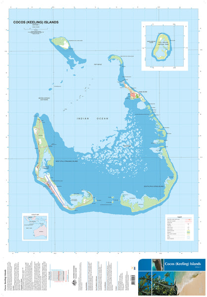
Cocos (Keeling) Islands Geoscience
$19.95
Afterpay is only available for orders between $50.00 and $1000.00 More info
The Cocos (Keeling) Islands Territory at 96°50'E and 12°10'S is Australia's most westerly tropical possession. The Territory is a series of 27 coral islands formed into two large coral atolls situated in the Indian Ocean about 2770 kilometres northwest of Perth. The islands have a total land area of 14 square kilometres and support a population of 572, mainly on Home Island and West Island.
The territory is one of the remaining pristine tropical island groups in the Indian Ocean region with abundant wildlife, particularly sea birds, and supports an internationally significant seabird rookery. The Islands also have land crabs, turtles, a range of flora and a marine environment with a wide variety of corals, fish, molluscs, crustaceans and other species. The northern atoll consists of North Keeling Island, and the marine area extending 1.5 kilometres around the Island forms Australia's most remote Commonwealth National Park, the Pulu Keeling National Park.
The islands were discovered by Captain William Keeling in 1609 but were not inhabited until 1826, when Alexander Hare settled on the main atoll. In 1827, a former employee of Hare, John Clunies-Ross, settled on Home Island and brought Malays to harvest coconut crops. Britain annexed the islands in 1857, and 29 years later, they were given to the Clunies-Ross family.
In 1978 the islands were bought from the family by the Australian Government, and in 1984 the islanders voted to retain their link with Australia.
If you want to use this map in the field, we can supply it on waterproof/tearproof DuPont™ Tyvek®. Tyvek® is made of pure polyethylene fibres (plastic) but has the properties of paper, which means it is foldable.
We can also laminate this map, allowing you to draw on it in whiteboard marker or apply our map dots to locations of interest without permanently marking the map. The lamination also makes the map very durable and protects against tears and stains.
Scale 1:25,000
Size 700 x 1000mm


