- Australia ▾
- Topographic
▾
- Australia 50k Geoscience maps
- Australia 100k Geoscience maps
- Australia 250k Geoscience maps
- Australia 1.1m Geoscience maps
- New Zealand 50k maps
- New Zealand 250k maps
- New South Wales 25k maps
- New South Wales 50k maps
- New South Wales 100k maps
- Queensland 10k maps
- Queensland 25k maps
- Queensland 50k maps
- Queensland 100k maps
- Compasses
- Software
- GPS Systems
- Orienteering
- International ▾
- Wall Maps
▾
- World
- Australia & New Zealand
- Countries, Continents & Regions
- Historical
- Vintage National Geographic
- Australian Capital Territory
- New South Wales
- Northern Territory
- Queensland
- South Australia
- Tasmania
- Victoria
- Western Australia
- Celestial
- Children's
- Mining & Resources
- Wine Maps
- Healthcare
- Postcode Maps
- Electoral Maps
- Nautical ▾
- Flags
▾
- Australian Flag Sets & Banners
- Flag Bunting
- Handwavers
- Australian National Flags
- Aboriginal Flags
- Torres Strait Islander Flags
- International Flags
- Flagpoles & Accessories
- Australian Capital Territory Flags
- New South Wales Flags
- Northern Territory Flags
- Queensland Flags
- South Australia Flags
- Tasmania Flags
- Victoria Flags
- Western Australia Flags
- Gifts ▾
- Globes ▾
Dear valued customer. Please note that our checkout is not supported by old browsers. Please use a recent browser to access all checkout capabilities
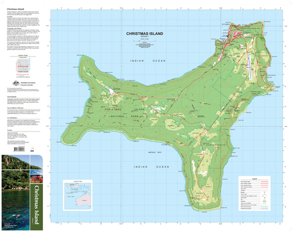
Christmas Island Geoscience Map
$19.95
Afterpay is only available for orders between $50.00 and $1000.00 More info
Located 2300 kilometres northwest of Perth, Western Australia, Christmas Island is at latitude 10°25'S and longitude 105°43'E. Christmas Island covers 135 square kilometres, of which approximately 60 per cent has been declared National Parks.
The Island is the summit of a submarine mountain, which rises steeply from sea level to a central plateau. The plateau reaches up to 361 metres and consists mainly of limestone and layers of volcanic rock. Surrounding the Island is a narrow tropical reef that plunges steeply to the ocean floor. Within 20 metres of the shoreline, you can find some of the steepest drop-offs in the world, reaching a depth of about 500 metres within about 200 metres beyond the edge of the reef. Combined with the diverse array of aquatic wildlife making its home in the reef, these undersea formations make diving around Christmas Island very popular.
Christmas Island is also famous for red crabs and their migration across the Island, which often causes havoc for the residents by blocking roads. This abundance of land crabs is not matched by any other island and has been described as one of the wonders of the natural world. More than 20 species of terrestrial and intertidal crabs have been described, including the huge robber crabs, or coconut crabs, which are capable of opening coconuts with their strong claws and eating the contents.
Phosphate mining has been carried out on Christmas Island since the late 1800s and remains a large contributor to the Island's economy. However, the focus is moving more towards tourism and related industries. The phosphate is derived from bird droppings.
If you would like to use this map in the field, we can supply it on waterproof/tearproof DuPont™ Tyvek®. Tyvek® is made of pure polyethylene fibres (plastic) but has the properties of paper, which means it is foldable.
We can also laminate this map, allowing you to draw on it in whiteboard marker or apply our map dots to locations of interest without permanently marking the map. The lamination also makes the map very durable and protects against tears and stains.
Scale 1:30,000
Size 700 x 1000mm


