- Australia ▾
- Topographic
▾
- Australia 50k Geoscience maps
- Australia 100k Geoscience maps
- Australia 250k Geoscience maps
- Australia 1.1m Geoscience maps
- New Zealand 50k maps
- New Zealand 250k maps
- New South Wales 25k maps
- New South Wales 50k maps
- New South Wales 100k maps
- Queensland 10k maps
- Queensland 25k maps
- Queensland 50k maps
- Queensland 100k maps
- Compasses
- Software
- GPS Systems
- Orienteering
- International ▾
- Wall Maps
▾
- World
- Australia & New Zealand
- Countries, Continents & Regions
- Historical
- Vintage National Geographic
- Australian Capital Territory
- New South Wales
- Northern Territory
- Queensland
- South Australia
- Tasmania
- Victoria
- Western Australia
- Celestial
- Children's
- Mining & Resources
- Wine Maps
- Healthcare
- Postcode Maps
- Electoral Maps
- Nautical ▾
- Flags
▾
- Australian Flag Sets & Banners
- Flag Bunting
- Handwavers
- Australian National Flags
- Aboriginal Flags
- Torres Strait Islander Flags
- International Flags
- Flagpoles & Accessories
- Australian Capital Territory Flags
- New South Wales Flags
- Northern Territory Flags
- Queensland Flags
- South Australia Flags
- Tasmania Flags
- Victoria Flags
- Western Australia Flags
- Gifts ▾
- Globes ▾
Dear valued customer. Please note that our checkout is not supported by old browsers. Please use a recent browser to access all checkout capabilities


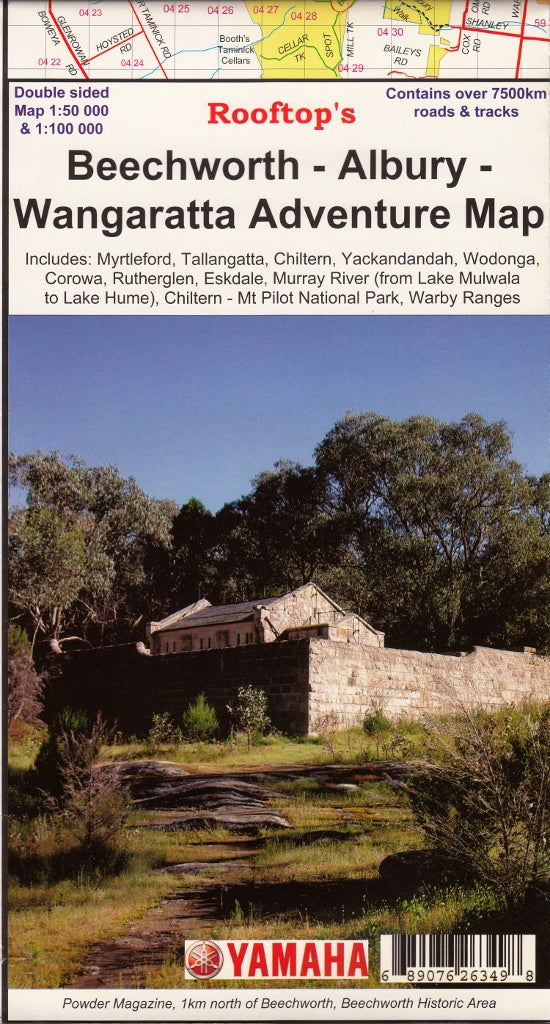
Beechworth - Albury - Wangaratta Adventure Map Rooftop
$10.95
Afterpay is only available for orders between $50.00 and $1000.00 More info
The Beechworth - Albury - Wangaratta Adventure map by Rooftop's is a brilliant topographic map of the area at a scale of 1:100,000 & 1:50,000 that includes a wealth of useful information from fire warnings, updates on track condition, suggested lookouts, opening times of amenities and much more.
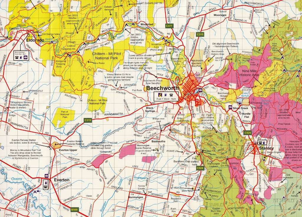
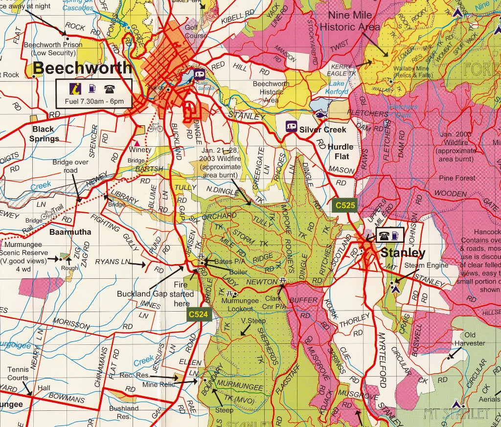
Beechworth Albury Wangaratta Rooftop Map coverage is from Rutherglen to Hume Weir and Tallangatta in the north and from Wangaratta to Myrtleford and Eskdale in the south. Beechworth is positioned approximately in the centre. Scale of the main Adventure Map is 1:100,000. The reverse side has a 1:50,000 enlargement titled 'Beechworth Forest Activities Map' giving good detail of Chiltern, Mount Pilot, Beechworth, Yackandandah and the State Forests around Stanley.
All parks, reserves and state forests are shown and more than 7500 km of roads and tracks have been plotted using GPS mapping technology.
This is the perfect map for walkers and 4 wheel drivers looking to really explore the region.
We can also laminate this map, allowing you to draw on it in whiteboard marker or apply our map dots to locations of interest without permanently marking the map. The lamination also makes the map very durable and protects against tears and stains.
Scale: 1:100,000 / 50,000
Opened Size: 700 mm (w) x 1000 mm (h)
Customer Reviews
Based on 1 review
Write a review
Related Items


© 2024 Mapworld. Website designed by Genie Media
X