- Australia ▾
- Topographic
▾
- Australia AUSTopo 250k (2025)
- Australia 50k Geoscience maps
- Australia 100k Geoscience maps
- Australia 250k Geoscience maps
- Australia 1:1m Geoscience maps
- New Zealand 50k maps
- New Zealand 250k maps
- New South Wales 25k maps
- New South Wales 50k maps
- New South Wales 100k maps
- Queensland 10k maps
- Queensland 25k maps
- Queensland 50k maps
- Queensland 100k maps
- Compasses
- Software
- GPS Systems
- Orienteering
- International ▾
- Wall Maps
▾
- World
- Australia & New Zealand
- Countries, Continents & Regions
- Historical
- Vintage National Geographic
- Australian Capital Territory
- New South Wales
- Northern Territory
- Queensland
- South Australia
- Tasmania
- Victoria
- Western Australia
- Celestial
- Children's
- Mining & Resources
- Wine Maps
- Healthcare
- Postcode Maps
- Electoral Maps
- Nautical ▾
- Flags
▾
- Australian Flag Sets & Banners
- Flag Bunting
- Handwavers
- Australian National Flags
- Aboriginal Flags
- Torres Strait Islander Flags
- International Flags
- Flagpoles & Accessories
- Australian Capital Territory Flags
- New South Wales Flags
- Northern Territory Flags
- Queensland Flags
- South Australia Flags
- Tasmania Flags
- Victoria Flags
- Western Australia Flags
- Gifts ▾
- Globes ▾
Dear valued customer. Please note that our checkout is not supported by old browsers. Please use a recent browser to access all checkout capabilities


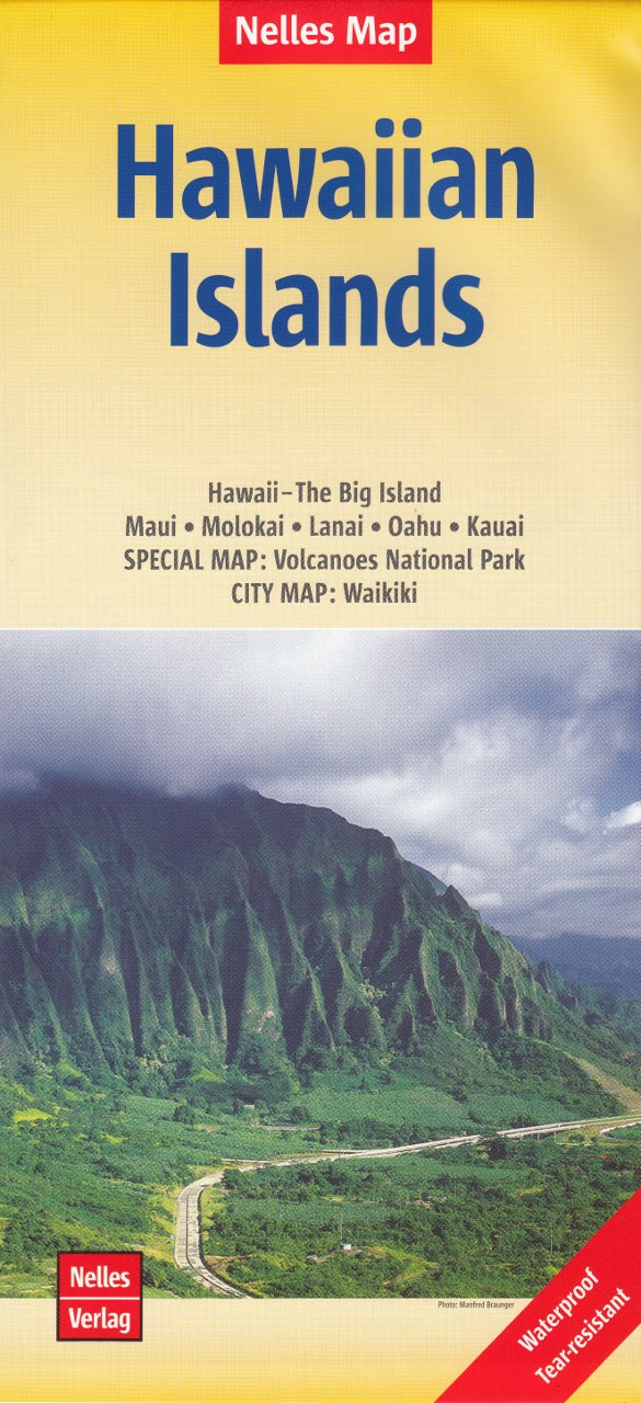
Hawaiian Islands Map by Nelles Verlag
Sold Out
Afterpay is only available for orders between $50.00 and $1000.00 More info
Includes Oʻahu • Maui • Kauaʻi • Hawaiʻi (Big Island) • Molokaʻi • Lānaʻi
With Insets of Waikīkī & Hawai‘i Volcanoes National Park
Explore the breathtaking diversity of the Hawaiian Islands with this beautifully rendered Nelles Map, designed for travellers who want both island-wide context and local detail. Covering the major islands in a convenient single-sheet format, this map is your essential companion for navigating the natural wonders and cultural treasures of the Aloha State.
🌺 Islands Covered:
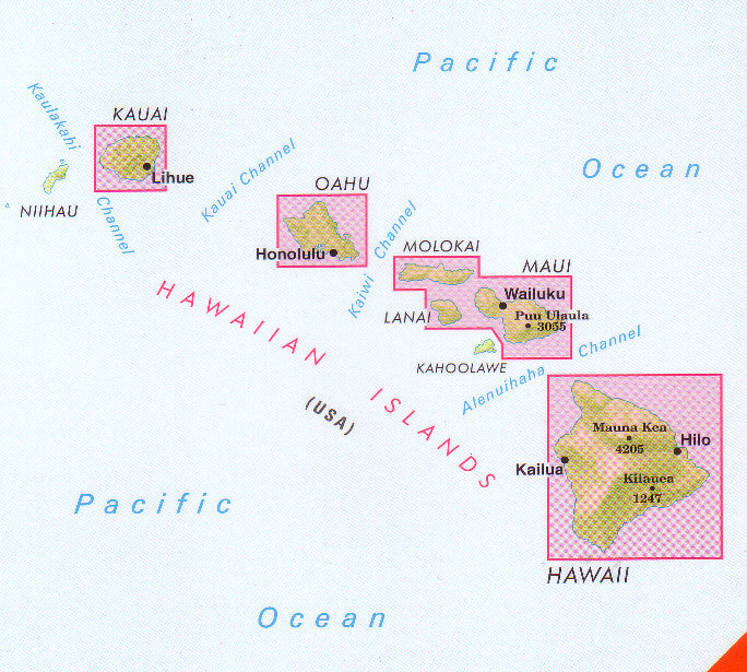
This map provides clear and comprehensive coverage of all six major inhabited Hawaiian Islands:
-
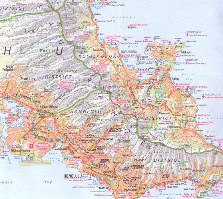
Oʻahu – including Honolulu and Waikīkī Beach
-
Maui – from the Road to Hana to the heights of Haleakalā
-
Kauaʻi – the "Garden Isle" with Waimea Canyon and the Nā Pali Coast
-
Hawaiʻi (The Big Island) – with Mauna Kea, Kona, Hilo, and Volcanoes National Park
-
Molokaʻi – secluded valleys and traditional rural life
-
Lānaʻi – rugged coastlines and off-the-grid charm
🗺️ Special Insets:
| Location | Scale | Features Highlighted |
|---|---|---|
| Waikīkī Beach, Honolulu | 1:14,000 | Hotels, shopping, beaches, attractions |
| Hawai‘i Volcanoes NP | 1:125,000 | Trails, craters, visitor centres, roads |
These focused insets give you the detail needed to explore two of the most iconic destinations in Hawaiʻi with confidence.
🧭 Map Features:
| Feature | Details |
|---|---|
| Map Type | Folded map, double-sided |
| Main Map Scale | 1:150,000 to 1:330,000 (varies by island) |
| Inset Map Scales | As noted above |
| Printed On | Durable travel paper |
| Cartography by | Nelles Verlag, known for travel accuracy |
✅ Why This Map Stands Out
-
🌴 All major islands on one sheet — easy reference while travelling
-
🗺️ Tourist-focused detail — includes major roads, towns, beaches, resorts, golf courses, scenic highlights, and national parks
-
🔍 Highly legible — even small towns and attractions are clearly marked
-
🧳 Ideal for self-drive holidays, cruise excursions, and flight island-hopping
Perfect For:
-
🌺 First-time visitors and repeat travellers to Hawaiʻi
-
🥾 Hikers and explorers visiting Volcanoes NP or Haleakalā
-
🚗 Road trippers planning drives along the coastlines and scenic routes
-
🧭 Anyone wanting a broad yet detailed overview of the Hawaiian archipelago
From the vibrant streets of Waikīkī to the volcanic craters of the Big Island and the lush cliffs of Kauaʻi, the Hawaiian Islands Nelles Map gives you the tools to plan and enjoy an unforgettable Hawaiian journey.
Frequently Asked Questions
Where can I buy the Hawaiian Islands Map by Nelles Verlag?
The Hawaiian Islands Map by Nelles Verlag is available to buy online from Mapworld, Australia's largest map and geographic product retailer, with fast shipping Australia-wide.
Is the Hawaiian Islands Map by Nelles Verlag in stock at Mapworld?
Mapworld maintains extensive stock across its map range and aims for fast dispatch. Orders placed before 2pm AEST on business days are typically dispatched the same day, with standard and express Australia-wide delivery options available.
What is Mapworld's returns policy?
Mapworld accepts returns on undamaged items in original condition. Contact Mapworld within 90 days of purchase to arrange a return or exchange.
Does Mapworld ship the Hawaiian Islands Map by Nelles Verlag across Australia?
Yes, Mapworld ships Australia-wide. Standard shipping is a flat $7 rate, with free standard shipping on orders over $75. Express options are available at checkout. Most orders placed before 2pm AEST on weekdays are dispatched same day.
Related Items


© 2026 Mapworld. Website designed by Genie Media
X